Green Line Extension to Medford & Union Sq

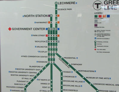
Updated MBTA map at ruggles, with glx D to union, E to Medford, new chelsea CR transfer stop, new gl bu stop spacing.

View attachment 18555

"The specific branch assignments are a reversal from earlier plans, which called for extending the D branch to Medford and the E branch to Union Square. Asked about the switch, Pesaturo said Friday that the D branch — which is by far the longest arm of the four Green Line branches — was assigned to the shorter extension to Union Square to make it a more reasonable length for trains."

“A shorter trip than the D branch, E branch trains have been assigned to the longer leg of the extension (Medford),” Pesaturo said in an email."

https://www.boston.com/news/local-news/2021/04/09/mbta-green-line-extension-union-square-october/

Presumably, the new BU green line stations should have the handicap symbols as well?

Also, the map makes it hard to tell if the SL has a stop at Downtown Crossing or not, at least to me
 
Ball square & magoun square stations
2E3ED5F6-942F-48BB-BF98-8DBD1502A9F0.jpeg
8840021E-DAD2-4E9B-9AAC-9137727797A6.jpeg
D7FEAC06-4CFC-46C2-BF55-05CE431F1ABD.jpeg
999A925D-A4A3-40A2-8007-784ECE3185A8.jpeg
A2ADD1A2-32E6-41D4-9E18-E5FE54A07913.jpeg
B86FD164-EDFD-4C37-A4B1-DFADBD1B5CC8.jpeg
927C194F-53FE-4C42-83D1-CD7A7E20F4F4.jpeg
62408EE4-F021-4ADB-8D70-8566BF1F3F04.jpeg
CE3E7CC6-DC5C-4363-BB2F-09AA32BE12C6.jpeg
 
Will the dirt slope in the last photo end up becoming a ramp to Lowell Street for the Community Path?

Also all the track closest to the community path has been laid in the last week or so. It used to end roughly where the comm path currently ends past lowell street, but now goes at least through the Magoun station.
 
There is already a ramp to Lowell visible on the right edge of the photo.
I'm familiar with the ramp that is there. The semi-temporary look of the metal ramp along with dirt slope being cleaned up a bit made me hope that there was going to be a nice grand entrance to the path from the bridge here.
 
With the B trains terminating at Govt Ctr, will both tracks at Park St still be used? I just got off a B train and it terminated at Park...
 
With the B trains terminating at Govt Ctr, will both tracks at Park St still be used? I just got off a B train and it terminated at Park...

Short answer, yes.

Longer answer, also yes but with more context. The Park Street loop is no longer in regular use as the B Line terminus, but it will continue to be used to turn trains as needed from the B, or any other branch. The Park Street loop returns to the status quo from before March 2014 when the B Line was cut back to Park Street with the start of the Government Center renovation shutdown.
 
For those who don't know, this is the plan for a new crossover from the inner loop to the through track just outside of Park Street Station. Please note that I posted this on another site in 2003! So don't hold your breath.

P.S. The inner loop will still get activity since the B trains will constantly be late arriving at Park Street. Haven't been there in a while but asking does anyone know it they have posted B Line loading signs at the outbound wall track? You know there will be lots of inattentive students with their ear plugs in that will not hear the announcements that the B trains will be on the inner track and will miss their train.

Corrected - not sure what I was thinking there.


Park Street Crossover.jpg
 
Last edited:
P.S. The inner loop will still get activity since the B trains will constantly be late arriving at Park Street. Haven't been there in a while but asking does anyone know it they have posted B Line loading signs at the outbound wall track? You know there will be lots of inattentive students with their ear plugs in that will not hear the announcements that the B trains will be on the inner track and will miss their train.

Did they swap the B berth over to the wall track? It's been on the fence track westbound for as long as I can remember.
 
No, I misspoke there. That would not be necessary. I retract that question :)

It's been a bit since I've been through Park Street, so I wasn't sure if they'd moved the berths or not. They swapped the D and E circa 2014 when Government Center shut down, so it's not like they don't change them at all. I hadn't heard anything so I was curious if that was a change or not.
 
We've seen the updated spider map at some of the stations, but has the MBTA posted any updated versions of green line map?
map-green.jpg
 
Looks like all or most of the poles for the catinary overhead wire have been installed! :)
 
Yes! At the new Green Line stops, Amory Street and Babcock Street, that opened today on the B Line.

awesome, thank you! the new green line stop tweets reminded me of this and i guess i just didn't look hard enough at the post!
 
Yes! At the new Green Line stops, Amory Street and Babcock Street, that opened today on the B Line.

View attachment 18865

The only thing I don't like about this map is that the Union Square and East Somerville stop look to be in the same location. For legibility, I think they should have made the Union Square terminal stop with a short segment at 45 degrees.
 
The only thing I don't like about this map is that the Union Square and East Somerville stop look to be in the same location. For legibility, I think they should have made the Union Square terminal stop with a short segment at 45 degrees.

Agreed. It doesn't match the shared station style, but they did that so subtly that it would be easy enough to confuse it. You'd have to look closely at the different style to tell the difference between Government Center (shared through/terminal station) and Union/East Somerville (separate stations), and that's never a good thing.
 

Back
Top