Harvard - Allston Campus

Until 1979, the Red Line used to turn southwest under Brattle Square to a storage yard where the JFK School of Government and JFK Park are now. The occasionally-used 'Stadium station' was in this yard, still on the Cambridge side of the river. This short section of tunnel still exists, but is no longer connected to the Red Line tracks. There's some talk that Harvard and/or the MBTA could reuse it for other transit purposes (a busway? a Green Line stub-end?)

Ron, as the tunnel still exists, why not extend it into Allston as part of the Urban Ring? If they propose spending $1.5 billion for an Urban Ring tunnel between Ruggles and Landmark, might not that money be better spent tunneling under the Charles and coming up to a surface transitway near or north of Western Ave.

I would hope if there is a modicum of feasibility for such an idea, that Harvard ought make allowance for the possibility of such in its forthcoming IMP, by creating and preserving a right-of-way.
 
I'm not sure how much of that Red Line tunnel extension still exists. I have a little pamplet/book about the construction of the Kennedy School and it shows the old train yard (where the school currently is) more or less being completely dug up. On a related note, there's a rumour around the school that there's an abandoned Red Line car burried under the building.
 
The yard is gone, but I've read that Harvard requested that the tunnel remain intact for possible future use.
 
From the Harvard Varsity Club website: Dillon Field House Remains the Center of it All. This building sounds important to students and alumni for historical and sentimental reasons, so I'm surprised Harvard is willing to dispose of it so casually.
Ron, wonderful story. Maybe they will save it!

Below are several sketches and site plans for the new residential houses. These are from the draft Harvard IMP, 2007 edition.

An aerial looking east. The new dirt pile is in the area down the left field line of the baseball field. The new field turf field is to the left of the tennis courts, and west of the kelly green astro turf field.

SNAG-01883.jpg


A site plan for the new residential houses. Orange means new, gray means keep. Blodgett pool is the orange building closest to N. Harvard, but is colored orange because it will be modified from a pool to some sort of campus center.

SNAG-01880.jpg


A rough elevation of the new buildings. This plan is not cast in stone, as I think the new field turf field(s) in the horseshoe bend is oriented east west, rather than the north south configuration depicted.

SNAG-01882.jpg


A sketch of the new buildings. The mini-tower is sited approximately where Dillon is currently. The two large buildings north and west of the stadium are the indoor track and field building (also with indoor tennis courts), and Murr Center (indoor tennis, squash, weight room).

SNAG-01884.jpg


Harvard's current use of Dillon:
[FONT=arial,helvetica,sans-serif]Dillon Fieldhouse is home to the Harvard Varsity Equipment Room, Sports Medicine Facility, as well as locker rooms for baseball, football, men's lacrosse, and men's soccer.
[/FONT]
[FONT=arial,helvetica,sans-serif]The Dillon Fieldhouse also houses several varsity coaches' offices including Baseball, Men's and Women's Cross Country, Football, Men's Hockey, Men's Lacrosse, and Men's and Women's Track and Field. [/FONT]

[FONT=arial,helvetica,sans-serif]On the second floor of the facility is the Dillon Lounge, which overlooks the Athletic Quad, and is fully equiped with a kitchen and bathroom. A popular space to rent, the Dillon Fieldhouse Lounge holds numerous functions including the Football Writer's Luncheon and team gatherings after games.[/FONT]
[FONT=arial,helvetica,sans-serif]I also erred in characterizing Palmer Dixon as an indoor tennis facility. In 2007, it was converted into Harvard's strength and conditioning facility. As it too is supposed to be demolished, one wonders what Harvard was thinking.
[/FONT]
 
7/25

img5809dy5.jpg


img5810gk8.jpg


img5811on3.jpg


this is just north of the big dirt area, and just south of the tennis courts

img5812qu9.jpg


and this is of the northern "horseshoe" area

img5817qd9.jpg


img5816mb4.jpg
 
Last edited:
kz, I think you mean 7/25 as the date for the pictures.

It looks like they will be putting down the field turf carpet pretty soon, and then we'll be able to see how many new fields there are.
 
Last edited:
Does anyone know if they will be doing repairs to the football stadium. I've been by a bunch of times and noticed a bunch of cracks
 
I've been having good luck when visiting this site. This time around one of the workers told me to just walk up to the edge of the excavation pit to take my pictures:

img6707yq6.jpg


img6708fu8.jpg


img6709rt3.jpg


img6710yo2.jpg


img6711du8.jpg
 
If I squint hard at the site plan above, it looks like Harvard plans on removing the ramps that connect JFK/Harvard Street and Storrow. Is this correct? That's a really big change.
 
^^ I think the ramps may be obscured by the new (foot?)-bridge over the Charles.
 
GW2500, I was taking a picture of the new field turf and, perchance, in the corner frame of the picture is a veritable large crack in the cement.

SNAG-01907-1.jpg


chumbolly, here is a sketch of a future street grid, showing where Harvard (presumably) would bury parts of Soldier's Field Road (Storrow Drive? I'm not sure where Storrow Drive begins exactly) and bring ramps up to grade at the Larz Anderson Bridge. At least, that's how I interpret the sketch. (White is where the road is a tunnel; the red brown is where there is surface roadway or boat sections. Purple is a new street.

SNAG-01907.jpg
 
I think the problem is that it's not clear what happens with the path along the river around the area where they are to depress the roadway and the interaction with the bridge.
 
Charlesview Keeps the Faith

By Andreae Downs
Globe Correspondent / August 10, 2008

They are preachers and teachers, but in the brouhaha over the future of the Charlesview Apartments, they've mostly been listeners.

"We have been listening and trying to be as sensitive as possible to the concerns raised," said the Rev. Samuel Johnson, pastor of the Community United Methodist Church and chairman of the Charlesview board of trustees.

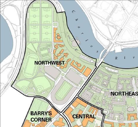
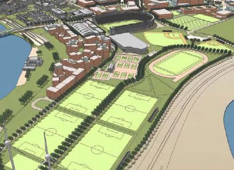
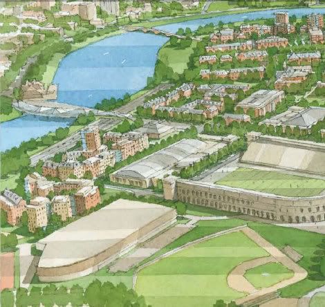
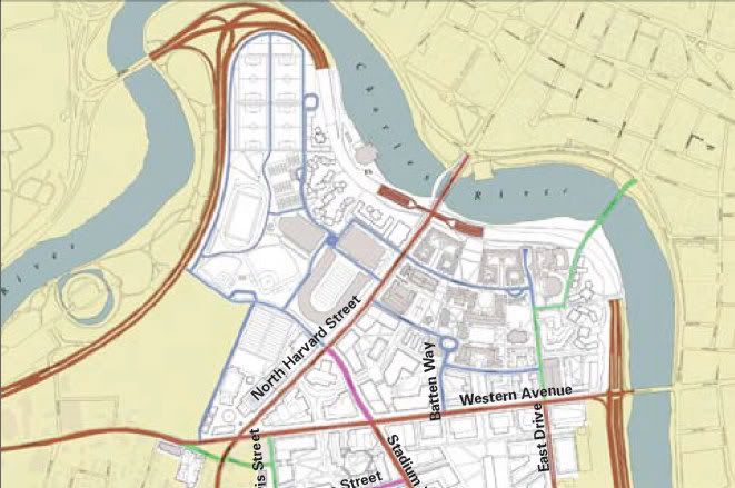
At issue are plans to raze the 213 Charlesview units at Barry's Corner and replace them with 400 apartments in the Brighton Mills area, where the land was obtained in a swap with Harvard University. The proposal has come under fire from neighborhood activist groups, which want shorter buildings, more open space, and better retail options.

But the trustees on the Charlesview board, created four decades ago from five mainline congregations to manage the apartments, say they represent a large, and less vocal, part of the community - the members of their congregations, as well as current and former residents of the Charlesview. And they're working with the developer, Community Builders Inc., to make sure their principles are being upheld.

According to Lawrence Fiorentino, a Barry's Corner neighbor and chairman of the board's development committee, "a lot of residents of Allston are former tenants of Charlesview." He added: "Everyone I've talked to on the board and in the community is excited about what is going to happen with Charlesview. Most feel it will be a jewel in the North Allston community."

For these constituents, density isn't a bad word.

Community Builders representative Felicia Jacques points to the new project's community center, increased retail offerings, and energy efficiency - which could include an energy cogeneration plant that requires density - as reasons why the structures will be an asset to the community. The board also wants to increase affordable housing options.

More to the point, Charlesview residents say, the current buildings are crumbling, and they need a decent place to live - fast.

"The walls are melting," said Raisa Shapiro, a tenant at Charlesview since 1990. The structure now is leaky, Shapiro said, and "large mice" are standard - more so since Harvard broke ground on its science center across the street.

"All my relatives are engineers," Shapiro said, "and they say, 'Run away! That's not safe!' "

Jacques said, "The physical plant at the existing Charlesview isn't safe in the longer term," which she put at three years.

Before construction can begin, however, many details remain to be worked out.

The proposal before the Boston Redevelopment Authority would be on 6.9 acres and include a 10-story building near the Charles River. At least one neighborhood group has suggested that the complex be spread out over an additional 13 Harvard-owned acres to reduce density.

In April, the BRA issued a "scoping" document that lists things the developer needs to address. It included recommendations to reduce density and make buildings shorter - more like surrounding properties.

"We are quite pleased with the BRA scoping," Johnson said. "We feel they support us and what we're doing." But, he noted, the trustees still want 400 units and, despite the calls for lower density, can't make plans to build on property they don't control.

Community Builders hopes to have an answer to the BRA suggestions by next month, allowing construction to start next year, Jacques said.

Activists say that to do that, the developer would have to ignore a big part of the scoping, which asks that the project take into account the BRA-sponsored communitywide planning process.

In general, the more vocal neighborhood activists say, the trustees leave too much of the planning to the developer. "We've reached out to all the congregations, and they've said their hands are tied, that Community Builders runs the show," said Tim McHale of Litchfield Street.

Controversy is nothing new to the Charlesview. In the early 1960s, the BRA had condemned the 9.3 acres of Barry's Corner - 4.5 acres of which house the current complex - as "blighted." The agency, fresh from flattening the West End, proposed razing the neighborhood of mostly single-, two-, and three-family homes and building a 10-story, 372-unit luxury apartment complex.

The resulting skirmish was recorded in William Marchione's book, "Allston-Brighton in Transition: From Cattle Town to Streetcar Suburb."

Paul Berkeley of the Allston Civic Association was in his 20s.

"I saw people dragged from their homes in handcuffs by the police, hundreds of people screaming and shouting; then a moving truck backed up to the house, emptied it, and then a bulldozer would come and knock it down," he said recently. That was when he decided to get involved in neighborhood affairs.

At about the same time, Fiorentino's mother, Josephine, was thinking Barry's Corner could use sprucing up. But the idea hatched at her Allston kitchen table - and shared by neighborhood activist Joseph Smith (now memorialized in the name of a local health center) - was for an affordable housing complex.

Fiorentino and Smith brought the idea to the monsignor of St. Anthony's, their parish, according to Lawrence Fiorentino. "At the time, houses of worship were the centers of community," he said.

The parish priest reached out to neighboring congregations for support, and after Methodist and Modern Orthodox congregations signed on, the group netted a $5,000 planning grant. Eventually, they persuaded the city to buy into the idea. In 1971, the Charlesview garnered a $5 million federally backed mortgage.

"Charlesview emerged as a kind of compromise," Marchione said in a recent interview.

Fiorentino knows of at least two original tenants who still live at the Charlesview. By the management company's estimates, about 40 percent of the tenants have been in place more than a decade.

Through consolidations over the years, the five original congregations have merged into three: St. Anthony's, Community United, and Congregation Kadimah-Toras Moshe. They serve about 1,300 people, or roughly 85 percent of the neighborhood.

But some things haven't changed over the years.

"What's amazing is how the five different congregations are still in lockstep," Fiorentino said. "The causes we champion are the same; the ways we go about that are the same."

Link
 
I erred. The design in the draft Harvard IMP (Institutional Master Plan) did not provide an intersection at N. Harvard and Soldiers Field Rd.

An alternatives analysis describing both the proposed decking configuration and alternatives that may provide a more equal balance of benefits to Harvard and the public at large. For example, the current proposal does not include the intersection of North Harvard Street and Soldier?s Field Road, yet that location offers a clear public benefit since it is at the nexus of a major north-south pedestrian, bicycle, and transit connection and the Charles River parks and pedestrian/bicycle path. While the proposal would inevitably be more complex given the need to accommodate automobile access between Soldier?s Field Road and North Harvard Street,

From the July 31, 52 page scoping document for the final Harvard IMP.
The pdf file can be found here:

http://www.cityofboston.gov/bra/pdf...ask Force IMP Scoping Determination Final.pdf
 
Hey guys,

If you bear with the following audio and pdf presentation about Harvard's plans for their Alston development you can get an idea of the planning they are putting into the development. This presentation was given at a construction symposium out at UMass Amherst.The audio file goes along with the pdf and explains what the slides are.

http://www.umass.edu/fp/BIM/Audio/Audio/Harvardpresentation.mp3
http://www.umass.edu/fp/BIM/Presentations/BIMHarvard.pdf

While Building Information Modeling seems cool in all the real important stuff is on page 11 of the presentation. Towards the end of the audio you can hear that they are designing all the plans with a transit tunnel under North Harvard Street. It good to see that Harvard is leaving all the transit options open.

I hope this isn't too unrelated to development for you guys.

Crash, thanks for the links. I listened to the audio and looked at the slides. The audio references a future MBTA Urban Ring tunnel. The slide shows that tunnel as going under a new street, called Stadium Way, which would run from Cambridge St. north to the east side of the Science I complex, cross Western Ave., and then through what is now the Charlesview housing complex, finally linking up to N. Harvard St. south of the stadium. The impression I got is that they are designing the utility infrastructure and, in doing so, making alloweance for such a tunnel if its ever built.

Perhaps Harvard will address this in the final version of its IMP; there was mention on this board a few weeks back that Harvard and the MBTA had retained an old tunnel that ran from Harvard Sq to the train yards where the JFK park now is at the corner of Memorial Drive.

How far-fetched would it be for Harvard to construct a concrete box under a portion of Stadium Way that could then be built out at a future date. It would be cheaper and far less disaruptive to build such a box while Allston is being built out then it would be to construct a tunnel after this part of the campus is nearly done in 20 years.
 
Dillon looks like something you'd want to keep and reuse for a different purpose. Is it definitely on the chopping block?
Ron, maybe Dillon will be spared after all. Harvard's current construction mitigation page stated that the new field turf fields are done, so I went to the Harvard athletics website to see if there were any pictures of the new fields posted. None yet, but lo and behold, a press release on a major upgrading of the football team locker room inside Dillon. Now, would Harvard be so carefree with its money to install a major upgrade and then tear the building down several years from now? Maybe yes, but perhaps not. This doesn't look like the type of upgrade they could rip out and reinstall in another new building.

http://www.gocrimson.com/ViewArticle.dbml?DB_OEM_ID=9000&ATCLID=1568212

HJJQITDPBXYRSSX.20080825170023.JPG


As part of its final IMP, Harvard is to include a schedule for the buildings it intends constructing in Allston over the next few years. The construction of the new field turf fields and a new soccer field supposedly makes land available for the new sports venues that will replace those facilities to be demolished to allow for new undergraduate houses along Soldiers Field Road near N. Harvard St. And the draft IMP sketches had Dillon demolished along with three other athletic facilities.
 
From other info I've seen, the eventual route of the light-rail urban ring line tunnel through the Harvard Allston campus is as marked by the red dashed line. It would tie into the abandoned Red Line subway tunnel near the Charles Hotel in Brattle Square.


harvard.jpg
 

Back
Top