I-90 Interchange Improvement Project & West Station | Allston

Re: I-90 Interchange Improvement Project (Allston)

Matthew, best for the public is not doubling or tripling the taxpayer's cost of an already expensive project to secure a relatively limited additional stretch of parkland along the Charles. Harvard wanted to cut and cover Soldiers Field Road in the area of N. Harvard St, so there would be sloping greenscape from the B school to the river, and from the Harvard athletic venues on the west side of N. Harvard St. (actually the venues were to be demolished and replaced by a new undergraduate house), and I assume Harvard was willing to pay for this. That idea died a very quick death.

It would be significantly cheaper to leave the existing Soldiers Field Rd configuration as is, deck it for extensive sections to create green space, than constructing an elaborate trench (and cover?) system that bisects a major highway with its major interchange. Complexity adds to the cost.

Except for that solves nothing to do with the traffpocalypse on Harvard Ave, Cambridge Street and the frontage road between Cambridge St and Western Ave. Increasing parkland along the Charles 500% is just a nice bonus to using SFR as a gigantic collector/distributor road to stop everyone in a mile radius of this exit from having to cram onto Cambridge St in a 200 foot span. You can't do that if it stays along the river, there's just no room.


Besides, as I noted on my diagram, the only place you're actually building a new right of way is the short stretch between Genzyme and Western Ave. The massive amount of exit 18 ramps to Cambridge St already exist where the SFR mainline would be moved to.

Edit: It's also hardly trivial, by removing SFR it allows the "west bank" of the Charles river to be nearly as wide as the esplanade! As I noted, it also eliminates expensive retrofitting of the bridges for cycling underpasses.
 
Last edited:
Re: I-90 Interchange Improvement Project (Allston)

Matthew, best for the public is not doubling or tripling the taxpayer's cost of an already expensive project to secure a relatively limited additional stretch of parkland along the Charles.

I wasn't talking about that. I don't know what will happen there anyway.

I was talking about all the worries people expressed for "Harvard's opinion of land use and street grid."

Fact is, we're paying $260+ million to open up Harvard's land for development. That's a windfall for them. We damn well better get something worthwhile for all that money beyond "a straighter pike."
 
Re: I-90 Interchange Improvement Project (Allston)

Harvard's opinion of land use and street grid will be very important. I agree that this project should result in a lot more than "a straighter pike", but I doubt that this project will result in much that Harvard opposes.

There is a big difference between trying to agree on desired land uses and proposing a transportation infrastructure that can support the desired land uses. At this stage, I'd say we try to resolve the minimal set of major decisions that need to be decided now.

Should Parcel X be housing, biotech, or a park? Does Windom Street extend to the south of Cambridge Street? In many cases I'm not sure it makes sense to debate that now and if we do it might lead to disagreement and conflict that makes it harder for us to build a strong consensus for the big things.
 
Re: I-90 Interchange Improvement Project (Allston)

Some additional comments, and caveated that I am not a highway engineer, but I've done more than a bit of civil infrastructure planning in my time.

1.) If I am driving a semi heading eastbound, and want to get off the Pike and drive into Cambridge, this is what I presumably would do.

Take Exit 19A, which is a left lane exit into a steep-grade, with a curving boat section to cross over the westbound pike then at its apex, the roadway immediately drops to below grade followed by a left lane merge with westbound Soldiers Field Road traffic. After merging, I proceed below grade a short distance, then cross lanes for a a right lane exit to exit #2, which leads to the new Pleasant St. At Pleasant St, there are two intersections with traffic lights before I cross one of two bridges into Cambridge (assuming both bridges are two way.) I doubt such a routing will fly, if only from a traffic safety standpoint.

2. ) How does one get off the Turnpike at Exit 19B?

3.) Taking Soldiers Field eastbound, there is another left lane merge with the eastbound Turnpike. One proceeds a short distance in the left lane of the Turnpike, before taking a left lane exit onto Storrow Drive. Probably also a non-starter.

4.) At where Storrow Drive and the Turnpike diverge, there is a proposed 12 lane cut to cover both. Interstate standards for the turnpike would require minimum 120 feet, 96 feet for eight travel lanes, 20 feet for shoulders, four feet for median. To this add four tracks for the railroad. Assuming the four track railroad right of way is 50 feet wide, that's a total of 170 feet for the Pike and the railroad. Still have to fit in Storrow Drive. Unfortunately, the total available ROW in that area looks to be 200 feet, which explains why the Pike is a viaduct over the railroad.
 
Re: I-90 Interchange Improvement Project (Allston)

1.) If I am driving a semi heading eastbound, and want to get off the Pike and drive into Cambridge, this is what I presumably would do.

Take Exit 19A, which is a left lane exit into a steep-grade, with a curving boat section to cross over the westbound pike then at its apex, the roadway immediately drops to below grade followed by a left lane merge with westbound Soldiers Field Road traffic. After merging, I proceed below grade a short distance, then cross lanes for a a right lane exit to exit #2, which leads to the new Pleasant St. At Pleasant St, there are two intersections with traffic lights before I cross one of two bridges into Cambridge (assuming both bridges are two way.) I doubt such a routing will fly, if only from a traffic safety standpoint.
Think about what you presently have to do, it's not much better. There is a left hand exit, followed by a toll booth, followed by a bridge across the toll plazas and a downgrade to Cambridge St, where there are two traffic lights to get through, and they back up A LOT. The grades are also not as steep as you may think, however I have reversed some things, what is now shown as a viaduct is at grade the entire time, while the WB mainline is what becomes a viaduct, since it has a much more gradual curve and longer running room.

2.) How does one get off the Turnpike at Exit 19B?
I'm not really sure what you mean. Exit 19 splits from the eastbound mainline just after Cambridge Street. From there it is its own two lane distributor road until halfway between Malvern and Babcock. At that point one lane branches off to the left to become Soldiers Field northbound and the other intersects with Babcock Street (a one way southbound) at a T intersection.

3.) Taking Soldiers Field eastbound, there is another left lane merge with the eastbound Turnpike. One proceeds a short distance in the left lane of the Turnpike, before taking a left lane exit onto Storrow Drive. Probably also a non-starter.
As was already pointed out, it is not so much an entrance and an exit as an interchange, which does allow left exits. The great majority of traffic will also be staying on their side, aka the pike traffic will be contuining on the pike, while SFR/storrow traffic will continue on their side. Having Storrow exit on the right instead would create dangerous weaving conditions. The only other way to do it would be to have both SFR and Storrow go underneeth the pike twice so it could come up on the right side. But this would require two more bridges, and may not even be possible with the railroad right there. As it is its running on a viaduct over the Pike from Pleasant to Comm Ave.

4.) At where Storrow Drive and the Turnpike diverge, there is a proposed 12 lane cut to cover both. Interstate standards for the turnpike would require minimum 120 feet, 96 feet for eight travel lanes, 20 feet for shoulders, four feet for median. To this add four tracks for the railroad. Assuming the four track railroad right of way is 50 feet wide, that's a total of 170 feet for the Pike and the railroad. Still have to fit in Storrow Drive. Unfortunately, the total available ROW in that area looks to be 200 feet, which explains why the Pike is a viaduct over the railroad.
Are you looking at this on your phone? Click the high resolution version if not. The proposed 12 lane OPEN cut I show is 181' wide. Due to the combined infrastructure, it takes up roughly 20' less than the current configuration with the railroad and storrow next to each other, with the Pike running on a viaduct on top.

Putting the railroad on a viaduct instead of the roadway makes sense from every way you look at it, and it is going to have to be rehabilitated eventually even if reused now. First, it will cost less to build due to a much smaller footprint, as well as being able to be open girders instead of requiring a deck with lighting, guard rails, etc. From a lifecycle standpoint, a railroad viaduct will last exponentially longer than a roadway all other things the same, as a railroad viaduct does not require salt in the winter, which eats away at the steel. As mentioned above, since it requires less materials to build, it will also be cheaper to maintain.

Then of course, with the mainline in an open cut, there is the potential to deck over the westbound mainline with a park.
 
Re: I-90 Interchange Improvement Project (Allston)

davem,

Thanks for your answers.

I now understand what you were doing with 19B and Babcock St. Though I am very skeptical that BU will embrace turning Babcock St into a major connector street. I would think BU views that area around Babcock and Ashford as its last contiguous chunk of developable land. (All Boston schools (except for Harvard and Allston) are land-poor.).

With 19A, its not enough to say 'its not worse than what's there presently', because it is worse. You have re-routed west-bound Storrow / Soldiers Field Rd away from the river, and it appears the only reason for doing so is to create park space. Its unnecessary from a traffic flow standpoint, and it greatly complicates the 19A flow regime because of 19A's cross-lane flow (crossing Soldier's Field westbound traffic) from a left entrance to a right exit.

From an analysis standpoint, your scheme would benefit greatly from elevation profiles, at least for the major alignments. My belief is that the reconstruction of the Allston interchange will need to comply with current Federal standards for interstate highways, standards which may be quite different from when the Pike was designed more than half a century ago.

The entire eastern end of your proposed configuration seems to be driven by the Grand Junction railroad, and facilitating x number of train movements a day over the Grand Junction. So to create a wye for the Grand Junction, the Mass Pike needs to be put 20? feet below its existing grade between Mountfort and Commonwealth, which crudely looks to be about a new 10 percent grade.

And because of the now depressed elevation of the Pike under and just west of Commonwealth Ave, eastbound Storrow would need to begin climbing in grade from about your Babcock St extended to where it diverges away from the Pike. Exit 20 is eliminated, because the Pike has to be so depressed immediately west of the BU bridge to allow for the wye, and for eastbound Storrow to cross above it.

Why do you need four railroad tracks from what is essentially Buick St. west?

Do you intend the Cambridge St and Western Ave bridges over the Charles to be two-way?
 
Re: I-90 Interchange Improvement Project (Allston)

You have re-routed west-bound Storrow / Soldiers Field Rd away from the river, and it appears the only reason for doing so is to create park space.

Shouldn't that be the primary goal of any change to this area?
 
Re: I-90 Interchange Improvement Project (Allston)

davem said:
as well as being able to be open girders instead of requiring a deck with lighting, guard rails, etc
Modern railroad viaducts must incorporate emergency egress.
 
Re: I-90 Interchange Improvement Project (Allston)

Modern railroad viaducts must incorporate emergency egress.

This is the sort of detail that's great if the idea is to make a realistic DOT-style plan sourced from AB (and I hope Dave does that because his plan is great). On the other hand, for Thursday's meeting we have to remember that this is one concept alongside MassDOT's concepts. Neither is more final than the others, and none of them represent what could/can/will be built.

The important part at this point is to make it clear to people that MassDOTs options should not be the only options. If it costs more than $275 million to loop in DCR and their massively inadequate facilities, then I'd be perfectly willing as a taxpayer to pay more money to fix more problems at once. The community should have a right to demand a solution that actually works, rather than a band-aid which will constrain the neighborhood's development and enforce dysfunctional traffic patterns.
 
Re: I-90 Interchange Improvement Project (Allston)

Of course. I was just correcting a small detail in his idea.

Thursday will be mostly about making sure that MassDOT knows that they have to come back to the people time and time again, and that the surrounding neighborhoods need to be improved by the project. Not 'just' a straighter Pike, and not just freed up land for Harvard. We need some real fixes for the problems that were created 50 years ago when the Mass Pike extension was blasted through here, as much as possible, and some better ideas for enhancing connectivity of all modes.
 
Re: I-90 Interchange Improvement Project (Allston)

So who is going, and would anyone be interested in meeting up a bit beforehand? I'm going to feel rather silly if I'm all alone with a 3' wide presentation board, even if you don't agree with all my ideas 100%.
 
Re: I-90 Interchange Improvement Project (Allston)

So who is going, and would anyone be interested in meeting up a bit beforehand? I'm going to feel rather silly if I'm all alone with a 3' wide presentation board, even if you don't agree with all my ideas 100%.

I'll be there. 6:30 is a little tight for me if I'm going to eat, but I suppose I could try to meet beforehand.

BTW, I'm uncertain if MassDOT will actually be present at this meeting. It might just be a community forum. It certainly is being well advertised though - they're handing out (he's handing out) flyers for it on the T.
 
Re: I-90 Interchange Improvement Project (Allston)

Thursday is the first official MassDOT public meeting.
 
Re: I-90 Interchange Improvement Project (Allston)

Allright, at Harrys suggestion I've removed all connections to the existing street grid. While I personally believe the streets should be extended, that's a battle for another day, and would be better served after some discussion/education. Babcock still needs to be extended through to Western Ave for traffic flow.

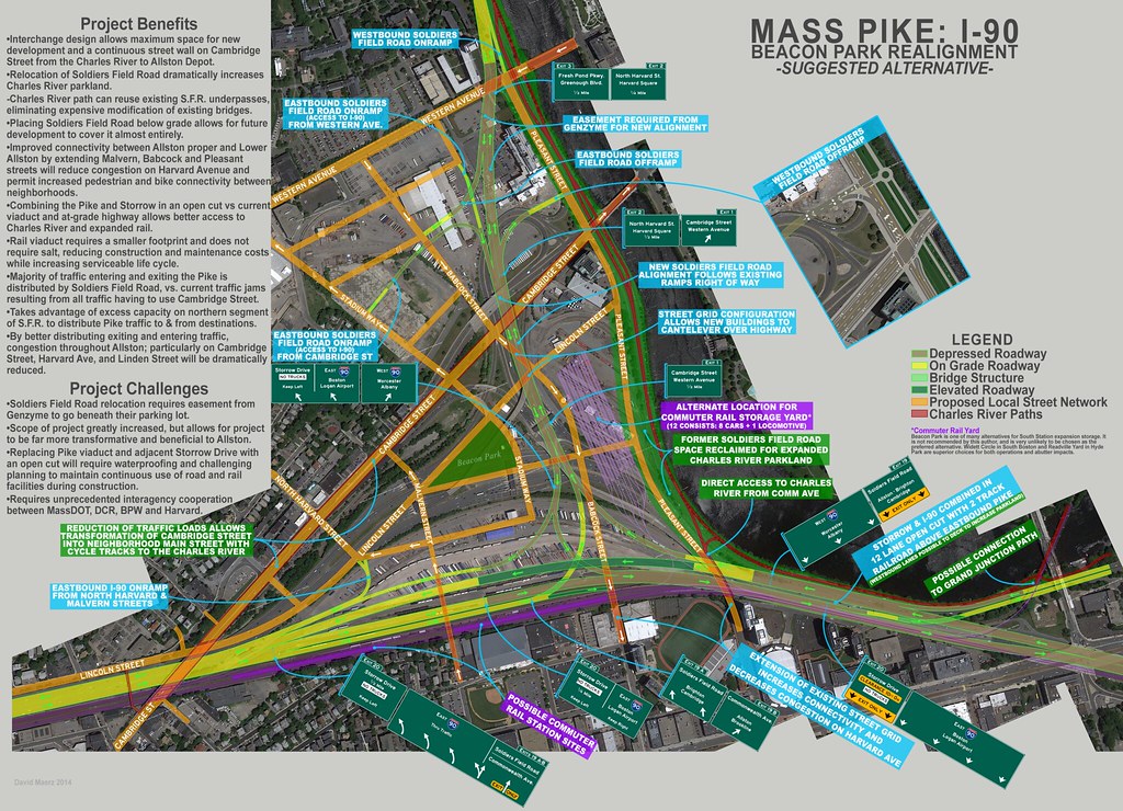
I've added some more bike and park connection benefits to try to get the parks/bike people liking this idea. Strong allies for a difficult proposal. Most notably are cycle tracks on Cambridge St, but I also added the Grand Junction path idea as well as a stronger visualization of the connection at Pleasant Street.

I also (hopefully) made the graphics more clear and concise. At others suggestions I reconfigured the interchange so there are less grade changes on the steep curves, I also think it will be easier to build. The CR over the Pike has been reduced from four tracks to two, and I made the CR yard a very apparent not likely option, with labeling as such. Also, while driving on Lincoln Street the other day, I realized if it was to be extended it would make infinitely more sense to do so as an underpass beneath Cambridge Street than somehow rising up to meet it at grade. This would require the bridge reconstruction project to be merged into this one, but that should have been happening from day one anyway.

Click for full resolution.

13702307023_c496b953c1_b.jpg


I now understand what you were doing with 19B and Babcock St. Though I am very skeptical that BU will embrace turning Babcock St into a major connector street. I would think BU views that area around Babcock and Ashford as its last contiguous chunk of developable land. (All Boston schools (except for Harvard and Allston) are land-poor.).
Babcock as I have it proposed is one way southbound, and only the traffic bound for Allston or Brookline would get off there (I didn't highlight it, but I would suggest a left turn restriction at Comm Ave to keep people from using this exit for Fenway access).

With 19A, its not enough to say 'its not worse than what's there presently', because it is worse. You have re-routed west-bound Storrow / Soldiers Field Rd away from the river, and it appears the only reason for doing so is to create park space.
I've addressed this before, but just to clarify, opening up land for an expanded park along the river is just a really great benefit. It takes a lot of room on this diagram because I am trying to get the bike/parks/NIMBYS on my side for this, and more parkland is a great way to show a real tangible benefit.
The reason for rerouting SFR away from the river is to reduce the massive clusterfuck that has been created by having everyone going to or from Arlington, Cambridge, Allston, Brighton, Brookline, East Watertown, and god knows where via the Pike have to use a tiny section of Cambridge Street. It causes the intersection by the double tree to be a disaster 20 hours a day. It causes retarded amounts of cars to cram through Allston's Union Square, Linden St, Harvard Ave, etc.
The only way to alleviate this is to distribute all the traffic instead of concentrating it at one point. So your two options are to build a gigantic spidering system of ramps, exits, and interchanges (inner belt, part 2), or use existing infrastructure. Soldiers Field Road west of Cambridge Street is humorously under capacity, and is perfectly poised to do this. But with it crammed right against the river there is no way to build an interchange with the Pike while still allowing through traffic from SFR to Storrow.
So, by using the existing alignment of the exit 18 ramps, plus a small easement through Genzymes parking lots, you fix all these issues, PLUS get 500% more parkland along the Charles River, a massive upgrade to the bike path, and less traffic in, around and through Allston.

That is worth the money.

Its unnecessary from a traffic flow standpoint, and it greatly complicates the 19A flow regime because of 19A's cross-lane flow (crossing Soldier's Field westbound traffic) from a left entrance to a right exit.
But not all cars will be doing this, as per my previous point. Only cars bound for Allston proper and Central Square will be taking Exit 1 off of SFR. The rest will stay on SFR further north/west. You are confusing the current configuration of ALL traffic (Allston, Brighton, Arlington, Cambridge, Storrow, SFR, East Watertown, etc) dumping off here, with only a fraction of that volume.

I freely admit this is not a 100% perfect configuration from a traffic engineering standpoint. But that's the whole point. Only being concerned with throughput is the reason this project is happening in the first place, it created a disaster for everyone not on the interstate. My proposal is a balance between the needs of highway users with those of the local road network, development potential, and parkland reclamation.

From an analysis standpoint, your scheme would benefit greatly from elevation profiles, at least for the major alignments. My belief is that the reconstruction of the Allston interchange will need to comply with current Federal standards for interstate highways, standards which may be quite different from when the Pike was designed more than half a century ago.
Getting paid for this would greatly benefit me having the time and resources to create them. Unfortunately, my computer has heat issues and I am neglecting my personal and professional work to get this done. I've been consulting the standards and attempting to apply them wherever possible. The lane widths are all correct, and the grades are vastly improved this iteration thanks to our previous discussion. The curvature of the ramps is restrictive, but less so than the brand new interchange they built by North Station.

The entire eastern end of your proposed configuration seems to be driven by the Grand Junction railroad, and facilitating x number of train movements a day over the Grand Junction. So to create a wye for the Grand Junction, the Mass Pike needs to be put 20? feet below its existing grade between Mountfort and Commonwealth, which crudely looks to be about a new 10 percent grade.

And because of the now depressed elevation of the Pike under and just west of Commonwealth Ave, eastbound Storrow would need to begin climbing in grade from about your Babcock St extended to where it diverges away from the Pike. Exit 20 is eliminated, because the Pike has to be so depressed immediately west of the BU bridge to allow for the wye, and for eastbound Storrow to cross above it.

Why do you need four railroad tracks from what is essentially Buick St. west?
It was a typo, there were actually only 3 tracks, and now there are two.The wye was an experiment I forgot to take out, I don't think it would have worked anyway. Although, the Pike is already below grade at Comm Ave, it rises after that. I'm just keeping it down.

Do you intend the Cambridge St and Western Ave bridges over the Charles to be two-way?
They aren't now, and changing that would royally screw up the entire traffic flow pattern from the river to Central Square, as well as the street rebuilding project they are just finishing up. This is why the one way pair ofBabbock Street and Stadium Way running from Western to Cambridge is so imperative, they supplement Pleasant St for cross-traffic. Currently the frontage road in front of Genzyme is a disaster because it is the only practical way to go from one one-way bridge to the other after N. Harvard St.
 
Last edited:
Re: I-90 Interchange Improvement Project (Allston)

REMINDER: this is tomorrow night!
 
Re: I-90 Interchange Improvement Project (Allston)

I wonder if they are going to get rid of the toll booths and put straight-through EZpass
lanes where vehicles don't have to slow down going through. :cool:
 
Re: I-90 Interchange Improvement Project (Allston)

I'm loving how much hype this is getting. I just really hope it doesn't devolve into the usual pissing contest and that everyone keeps working together.

I doubt it. But let's see how the meeting tonight goes.
 

Back
Top