I-90 Interchange Improvement Project & West Station | Allston

Re: I-90 Interchange Improvement Project (Allston)

Very nice renderings. I don't think Agganis is a viable bridge candidate - you need to keep the loop to Buick Street and I'm not sure you could do that while adding a bridge.
 
Re: I-90 Interchange Improvement Project (Allston)

Yes, it was a good read. I see that you took pictures during the graduation. Normally that area is fairly desolate.

Ashford Street descends a fair amount between Malvern and Babcock Streets. I don't know if BU will be to keen on rebuilding the stub of Babcock Street to raise the grade. Admittedly, I suspect BU is not at all thrilled with the idea of making Babcock Street be a thru-street. Politics may be the largest challenge of all.

Any overpass should probably be combined with access to the planned four-track/two-platform station that MassDOT is thinking about creating in the Beacon Park space.

BTW, the next Interchange Task Force meets Wednesday, May 21st, at 6:00PM, Honan Library 300 N Harvard St.

Heh yeah, the cops were all giving me strange looks. Regarding the two buildings that would have to be modified along with the stub of Babcock, I can't imagine those two buildings are all that important to BU. I doubt they are too keen on turning these dead ends into full-on streets either, but unfortunately for them they are public streets. Frankly, with all the weight BU has pushed around to get their way, I think they can give a bit of a concession that would benefit the entire area immensely.

Very nice renderings. I don't think Agganis is a viable bridge candidate - you need to keep the loop to Buick Street and I'm not sure you could do that while adding a bridge.

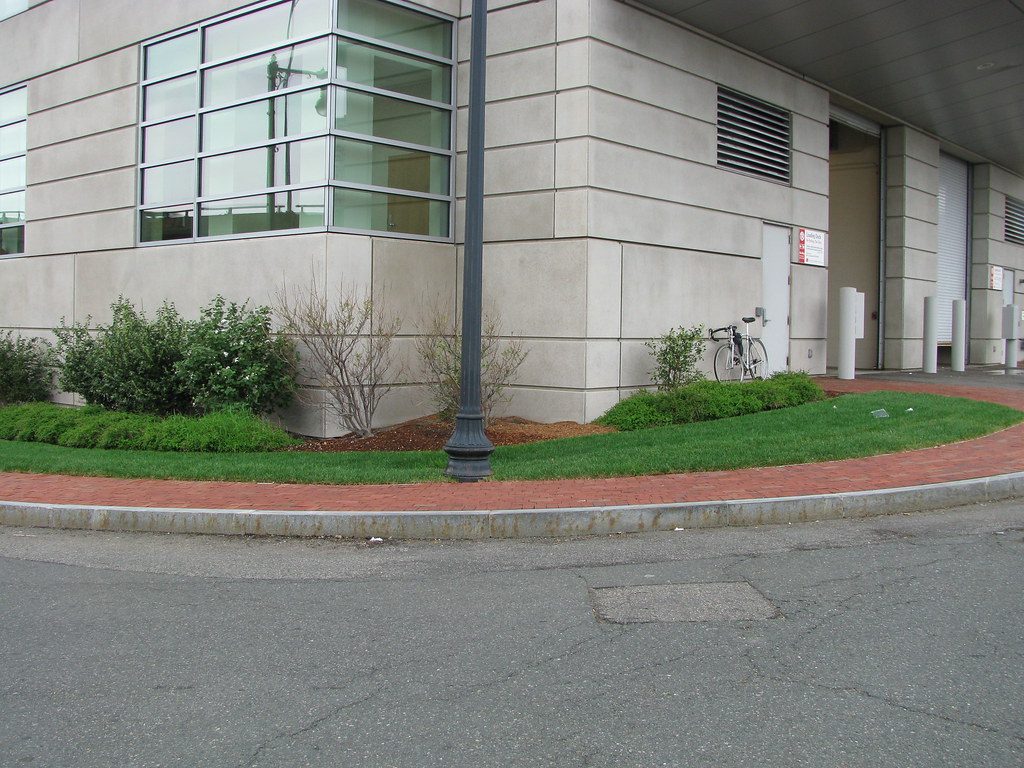
The bridges incline would begin roughly where my bike is. You could keep the loop as long as you raised the grade on buick street a few feet. It wouldn't effect the dorm at all.
14220876791_61cce8bd2d_b.jpg


You can see below they could regrade the whole thing with little negative effects.
14037642739_76340ea8a8_b.jpg
 
Re: I-90 Interchange Improvement Project (Allston)

Hey Matthew, whats your source for the two platform four track west station?
 
Re: I-90 Interchange Improvement Project (Allston)

A fellow named Matthew Ciborowski, a MassDOT Project Manager, that I spoke to at the most recent task force meeting.

You should come to the next meeting on Wednesday ;)
 
Re: I-90 Interchange Improvement Project (Allston)

Great ideas. I think Malvern is the only worthwhile overpass for connecting the neighborhoods. The Agganis connection to Soldier's Field Road doesn't accomplish much of anything for pedestrians, and the Babcock connection requires a much longer overpass and wouldn't serve as much of either neighborhood as Malvern.

Malvern is great. It could potentially hook right into North Harvard St, and serve a direct pedestrian and bike connection from the heart of North Allston right into Packard's Corner and the Green Line. It's really the only option that changes the calculus of the game away from the Linden St crossing.
 
Re: I-90 Interchange Improvement Project (Allston)

I agree that Malvern is well-situated. Thinking out loud... Two problems: the connection of Malvern and Packard's Corner is awkward; you have to head over to Babcock Street if you want to travel eastbound on Comm Ave. Second problem: the corner of Malvern and Ashford is currently a quiet area without much traffic. A little traffic engineering was done years ago on the corner, actually, to prevent cut-through traffic to the Pike. Presumably that wouldn't be an issue anyway. The house closest to the intersection is not owner-occupied, it's a rental property owned by some doctor in Newton.

Now, there will be a new apartment building owned by Hamilton on that corner, I don't think they will raise an issue with the overpass. The DOT would have to take a piece of land from BU or whoever owns that industrial property that used to be a sterilization facility. The right-of-way for the overpass will pass close to several owner-occupied homes on Sawyer Terrace. That might be an issue but can probably be mitigated. Might be the stickiest point, actually.

So yeah, unless Packard's corner is radically reengineered (I'm open to the idea) there will still be significant traffic flows induced down Babcock Street. So you're back to fighting BU either way.
 
Re: I-90 Interchange Improvement Project (Allston)

Why would it be such a big deal to allow cars to turn onto Eastbound Comm? Just simply move the Brighton Ave stop line in back of the median cut and add a new signal phase to allow southbound Malvern Street to enter the intersection and go any which way.
 
Re: I-90 Interchange Improvement Project (Allston)

I think that would make the intersection significantly worse (than it already is) for pedestrians and the Green Line. Nibbling around the edges won't do for this purpose.
 
Re: I-90 Interchange Improvement Project (Allston)

That's why you can't just do Malvern. Its terrible for cars, babcock is much better for that purpose. But for pedestrians in the current developed area, Malvern is the best.

Agganis Way only makes sense if SFR is moved. But its the best way for cars to access the Pike from Comm Ave, and for bikes/pedestrians to get to the charles river path. But thanks to the embankment its also the easiest.
 
Re: I-90 Interchange Improvement Project (Allston)

That's why you can't just do Malvern. Its terrible for cars, babcock is much better for that purpose. But for pedestrians in the current developed area, Malvern is the best.

In that case, why not head off the biggest NIMBY issue and make the Malvern overpass bike/ped only? That street is pretty clearly not intended for though traffic.

That would make Babcock the primary vehicular route from BU to North Allston and Harvard. It's important to note, Dave, that travel times won't improve much for cars here - you're justifying the overpass by taking the cars off of Linden, Harvard and Cambridge. That's great, but it will require that Babcock be built to a standard beyond that of Harvard or Linden. Getting BU to agree to an overpass is one thing, getting them to agree to expand Babcock to arterial dimensions through their service access area will be harder.
 
Re: I-90 Interchange Improvement Project (Allston)

Can I just take this moment to make the obligatory induced demand announcement: an additional connection between Comm Ave and Cambridge Street will not alleviate Harvard Ave/Linden Street congestion because there is more than enough latent demand for Harvard Ave that it will fill right back up.

But, regardless, a Babcock Street (or similar) overpass would make life a lot easier for everyone living in Packard's corner, and motorists coming from the east. Even if it is no wider than Babcock Street currently is (and I think should remain that way).
 
Re: I-90 Interchange Improvement Project (Allston)

From yesterdays Task Force meeting. They presented a LOT of options, which was really great. This is the last, 3F, which IMO is the best iteration of the designs. Sorry about the annotations, I was jotting down my thoughts before the meeting started.

14059196827_ffd6344339_b.jpg


On all the versions they have included a road to/from SFR inbound. This is a great step forward IMO, as they are looking at getting traffic off Cambridge St that doesn't need to be there. That street will also be the new entrance to the Doubletree, removing an extra light cycle from the Cambridge St/SFR intersection.

Another good element is the multiple points of egress from C-bridge St to the Pike frontage roads. A N.Harvard St resident and another Windom St resident brought up that they don't want the existing neighborhood streets to be used as a cut-through. They are pressing the DOT to include the blue streets as part of the project, to funnel some of the Western Ave to C-bridge St traffic away from the neighborhood. However, a DOT guy asked if the residents also wanted to see the streets extended for their own use, which they agreed with. That's a really good sign, IMO. The community wants permeability, but also wants to make sure no new traffic is induced.

Some really good back-and-forth between the task force and the DOT guys. One made the mistake of saying they were accommodating projections for future traffic increases, and a longgg conversation went on about trends showing overall volumes may decease. This is going to be an uphill battle.

There was also a pretty productive conversation on what the land will be used for after the project is complete. Lots of conversation on maximizing developable land, ensuring the design doesn't disallow future improvements, etc. The rail yard is being designed with air rights in mind, space for columns is being put into the design from the get-go.

Regarding the rail yard, it will be for 20 consists, in addition to leaving space aside for a two-platform West station. They dropped the bomb that the station is NOT part of this project, and isn't budgeted for.

Another big point of contention was North-South access, as I wrote about on my blog. I actually asked the guy to put his laser pointer on Packards Corner, and then demonstrate how one would get to the other side of the tracks. After a bit more discussion the light bulb seemed to go off that some form of access, whether vehicular or just a mixed use path, is critical to get from Comm Ave to C-bridge St.

They didn't appear to investigate crossings too in-depth yet, as they quoted the 20-something foot grade change to get over the tracks. After the meeting I brought up that Ashford Street is considerably higher than the land right next to the tracks, and that I did some rough calculations and found a crossing to be feasible. They also pointed out that the land is privately owned, however after come questions from the task force did say that some eminent domain and/or acquisitions would be within the scope of a project this large if it was deemed truly vital (which everyone semed to agree it is).

That's it for my flow-of-consciousness report. They should be dumping a bunch of project information (traffic numbers, designs, etc) "soon", so that will be interesting when it goes up.
 
Re: I-90 Interchange Improvement Project (Allston)

I thought the T didn't want a rail yard there. Is that just conceptual?
 
Re: I-90 Interchange Improvement Project (Allston)

I thought the T didn't want a rail yard there. Is that just conceptual?

F-line argued that they didn't. I'm getting my info from the T (his name escapes me, but he made a point of coming up to me at the first community meeting to tell me they are doing beacon park. Apparently my alternate design made its rounds more than I realized.) Basically they want two yards. The one at beacon park would be for Worcester and some NEC trains, and the other (readville or widett) is for old colony, south coast, fairmount and other NEC trains.

The reason they want two layover yards is so they don't have to foul the entire south station ladder taking trains in/out of service. If you have a worcester line train on track 1 and send it to widett, it has to cross nearly every track to get there. If it derails, you have the potential to block the entire NEC main and then some.
 
Re: I-90 Interchange Improvement Project (Allston)

Cool. Great info, and probably the right move. Just too bad that it means they can't straighten the Pike even more.
 
Re: I-90 Interchange Improvement Project (Allston)

From yesterdays Task Force meeting. They presented a LOT of options, which was really great. This is the last, 3F, which IMO is the best iteration of the designs. Sorry about the annotations, I was jotting down my thoughts before the meeting started.

I like the direct link to SFR EB, and I appreciate the work that went into designing those roads to minimize left turns (like the jughandle viaduct), but I'm not sold on this. [REDACTED]...

The other issue with that is that if they actually do a vehicular overpass on the railyard (and they need to) it will add even more intersections where it hits the jughandle. The way that the rail station is shoehorned in there, access from Allston and Cambridge will require going all the way around behind BU if cars and buses (not to mention sidewalks) aren't going to be gumming up the ramps. Given that the MBTA has shown a preference for a bus hub at this site, that's probably not an option.

Instead, I reworked Alternative 1A to include a little more urbanity:

14wszza.jpg


Some highlights:

The neighborhood streets go through where MassDOT included a median cut, but they don't have Pike access. That allows the neighborhood to use them to access whatever's built on that side of Cambridge St (or the Babcock St. overpass) but precludes them from being easy cut-throughs. The intersection of Lincoln St. and the on-ramp could have no turning allowed (probably a good idea for several reasons) and force all Pike-bound traffic to the access road.

Given that geometry likely won't allow for direct ramps from SFR to the Pike, I liked the idea from Alternative 1D (1A with a ramp relocated) of a direct slip ramp from SFR parallel to Cambridge St. The problem in that plan was that it intersected one of the new Harvard roads at right angles, creating a left turn scenario. Here, I rerouted the Harvard road (which would just be called Babcock St.) so that the intersection of its access road and the SFR access road would be a simple merge. This also moves some traffic away from Windom St, though it does add a signal with Cambridge St.

That leaves SFR EB to Pike EB with four 2-phase signals to traverse. Some of those could be further avoided if MassDOT were to invest in taking them off-grade. The intersection of the access road and Cambridge St. would be a good candidate for that.

Continuing Babcock on this ROW allows for any development there to front a through street, and one running right next to the station. I don't know what air rights MassDOT thinks they'll sell over the yard, but you could access the development via an above-grade intersection with Babcock without interfering with Pike traffic (another shortcoming of 3F).

This is definitely moving in the right direction! Each round of alternatives is better than the last, and that's important.
 
Last edited:
Re: I-90 Interchange Improvement Project (Allston)

I like the direct link to SFR EB, and I appreciate the work that went into designing those roads to minimize left turns (like the jughandle viaduct), but I'm not sold on this. That's FIVE signalized intersections from SFR EB to I-90 EB, and that's assuming they build the stub road through - it's six if they don't. That's just not workable, even without left turns.

Unless I'm missing something, but in 3F its only three intersections. One gets off EB SFR at the stub road, bangs a left on the furthest east street, then another left onto the EB Pike.

I like the rest of your idea, but I'm too tired right now to comment. New job, blech.
 
Re: I-90 Interchange Improvement Project (Allston)

Unless I'm missing something, but in 3F its only three intersections. One gets off EB SFR at the stub road, bangs a left on the furthest east street, then another left onto the EB Pike.

I like the rest of your idea, but I'm too tired right now to comment. New job, blech.

Zooming in to 300%, one of those tiny arrows does indeed face the other way. Fair point.
 
Re: I-90 Interchange Improvement Project (Allston)

I feel like the task force is being steered towards one of the option 3 variants.
 

Back
Top