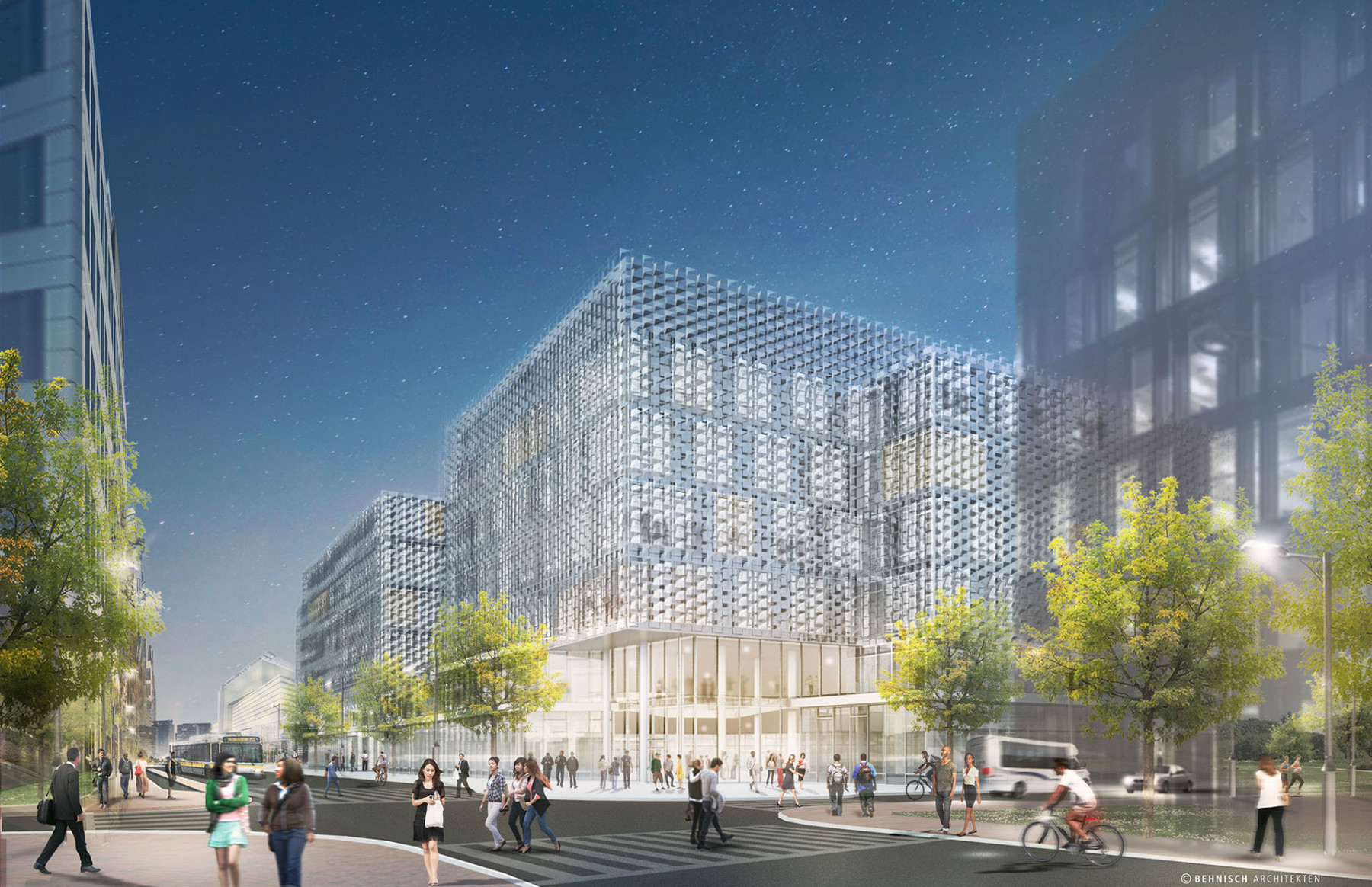
I'm having a hard time finding a news article on this, but I'm pretty sure that BU bought Babcock Street from the city of Boston a few years ago specifically so that they could block a flyover street into lower Allston. The idea is to mitigate traffic in BU West. The above rendering has a development on top of the existing rail-yard linking BU to LA. I wonder if BU would try to fight that?
You are using an out of date browser. It may not display this or other websites correctly.
You should upgrade or use an alternative browser.
You should upgrade or use an alternative browser.
I-90 Interchange Improvement Project & West Station | Allston
- Thread starter Matthew
- Start date
If the city and state don’t squeeze the living fuck out of BU and force not one but two REAL and two way street connections, I have lost all hope for this idiotic, fiefdom-ruled state. This could change all the connectivity problems - both infrastructure and cultural - forever... or freeze them in time.
I'm having a hard time finding a news article on this, but I'm pretty sure that BU bought Babcock Street from the city of Boston a few years ago specifically so that they could block a flyover street into lower Allston. The idea is to mitigate traffic in BU West. The above rendering has a development on top of the existing rail-yard linking BU to LA. I wonder if BU would try to fight that?
I believe they are ok with ped and bike crossings and bus connections to train (but not crossings). They just don't want it to turn into a busy turnpike access route, which would actually happen if it was connected.
I am very confused by that image. It seems to show a whole host of streets "T"ing into Soldiers Field Road, when I thought the only new connection was for Cambridge Street?
That image doesn't come from any work by MASSDOT or the actual project.
It comes from a two day workshop held by the Boston Society of Architects
Harry Mattison
Active Member
- Joined
- Dec 14, 2007
- Messages
- 162
- Reaction score
- 102
Lots of great comments! Here are a few ways to get involved
Join the community email list for this project: http://eepurl.com/RGQZr
https://twitter.com/peoplespike
https://www.facebook.com/groups/PeoplesPike/
November 30: MassDOT Task Force meeting (open to public) - 6pm, 123 Antwerp Street Brighton
December (date TBA): MassDOT MEPA public information meeting
December 6 - January 5: Comment period for written feedback to be sent to:
Patricia Leavenworth, PE MassDOT, Chief Engineer
10 Park Plaza
Boston, MA 02116
Attn: Bridge Project Management - Project File No: 606475
dot.feedback.highway@state.ma.us
tangent
Senior Member
- Joined
- May 11, 2012
- Messages
- 1,790
- Reaction score
- 68
All of them show partial filling in of the Charles. Its highlighted in red in the proposals. Its not much, but its there.
I see it in both places. Just can't fit it all in there at ground level without widening the land area at the narrowest point just a bit.
As much as the waterways and wetlands stuff would really really suck to have to go through it would probably save our kids and grand-kids a boatload of money on maintenance and wouldn't have much negative impact on either the riverbank or the navigability of the Charles.
In terms of the visual impact of a wider stretch of transportation versus the elevated viaduct... I'd have to say the elevated viaduct is more disruptive.
Gameguy326
Active Member
- Joined
- Aug 18, 2015
- Messages
- 390
- Reaction score
- 98
I agree with people saying that putting this below grade makes a ton of sense. It's a shame that The Big Dig has scarred everyone to these (immensely valuable) projects.
tangent
Senior Member
- Joined
- May 11, 2012
- Messages
- 1,790
- Reaction score
- 68
I see it in both places. Just can't fit it all in there at ground level without widening the land area at the narrowest point just a bit.
As much as the waterways and wetlands stuff would really really suck to have to go through it would probably save our kids and grand-kids a boatload of money on maintenance and wouldn't have much negative impact on either the riverbank or the navigability of the Charles.
In terms of the visual impact of a wider stretch of transportation versus the elevated viaduct... I'd have to say the elevated viaduct is more disruptive.
Just thinking this through a bit... i wonder if you could avoid some or all of the wetland/waterway fill by moving the tracks onto BU property more. Take the surface road behind Agganis Arena and some of the property behind the BU buildings there. Could elevate the surface road above the relocated tracks possibly or just relocate the access road a bit.
Just thinking this through a bit... i wonder if you could avoid some or all of the wetland/waterway fill by moving the tracks onto BU property more. Take the surface road behind Agganis Arena and some of the property behind the BU buildings there. Could elevate the surface road above the relocated tracks possibly or just relocate the access road a bit.
Cannot elevate the road or move it. Building deliveries and trash pickup for the original StuV buildings are right on the access road, and its located at the roads lowest and narrowest point.
stick n move
Superstar
- Joined
- Oct 14, 2009
- Messages
- 13,482
- Reaction score
- 24,540
"Designs for the project are 15% complete and should be finished in 2019. After that design process, the agencies would begin the process of finding a contractor with the goal of starting work in 2020."
1.2 billion estimated cost

http://www.wcvb.com/article/cost-of-mass-pike-allston-interchange-project-could-be-dollar12-billion/13598691
1.2 billion estimated cost
http://www.wcvb.com/article/cost-of-mass-pike-allston-interchange-project-could-be-dollar12-billion/13598691
Charlie_mta
Senior Member
- Joined
- Jul 15, 2006
- Messages
- 5,150
- Reaction score
- 7,778
1.2 billion estimated cost
Makes sense. Any transportation project of this type goes for at least a billion. It's worth it.
I especially like the addition of the new underpass on Soldiers Field Road, for Storrow/Pike traffic to bypass the Cambridge Street bottle neck.
stick n move
Superstar
- Joined
- Oct 14, 2009
- Messages
- 13,482
- Reaction score
- 24,540
What are the chances that $1.2 Billion price tag balloons between now and 2020?
Also, does anyone have a high res photo of the plans?

One thing i don't get is why they don't connect to Babcock street, and even maybe Malvern st. Two roads head directly towards them and then just end at west station.
stick n move
Superstar
- Joined
- Oct 14, 2009
- Messages
- 13,482
- Reaction score
- 24,540
This is older and not exactly the same but its pretty close and gives a good idea of another perspective.


stick n move
Superstar
- Joined
- Oct 14, 2009
- Messages
- 13,482
- Reaction score
- 24,540
Somewhat of an idea of the difference in view from ground level vs the viaduct you come out of now.

I think it will make the city feel more connected further out with this area developed along with New Balance and not having the Allston interchanges which kind of mark the entrance to the city. Once this is built it will be more seamless and it wont feel like your finally in the city once you get through the tangled mess here. Should pull the city out to New Balance without this barrier you have to get to before your in "the city". After build out the pike will just flow through this area like anywhere else so it wont be so much of a barrier cutting off everything further west off from the city. It seems like it will make the city "feel" like it goes further out west vs now once you hit this interchange it feels like you are now either entering or exiting the city.
I guess what Im getting at is this is going to basically go straight into the city vs now where you have to go into the Allston interchanges which feel like the barrier between here and the city. Once its completed you'll essentially flow straight through and it will feel more connected. You'll also have essentially a new seaport style district to the left of you as you pass through which pulls more of the development westward down the pike.
stick n move
Superstar
- Joined
- Oct 14, 2009
- Messages
- 13,482
- Reaction score
- 24,540
A couple proposals for the general area.
What are the chances that $1.2 Billion price tag balloons between now and 2020?
The $1.2 billion price tag includes $500MM of cost overruns, so... it might go up, but there's quite a buffer there
What is the revenue that they are getting from the new land?
I believe Harvard will own all/most of the land, so I'm not sure why the state would be getting revenue. The state got money when the MTA sold land to Harvard ~15 years ago. (There were multiple transactions at the time, and there have been transactions since then for removing certain encumberances on the land, involving payments to CSX, Houghton Chemical, and probably others.)
Proposition Joe
Active Member
- Joined
- Oct 24, 2012
- Messages
- 307
- Reaction score
- 3
I like how the street grid MassDOT penciled in is still, after all these years, composed of Commonwealth Ave sized streets. Can literally anyone at MassDOT read up on current trends in their field so as not to totally balls up this new neighborhood?
Why is all of this garbage road infrastructure elevated on viaducts? Why build a Soldiers Field Road underpass? Just calm the road so that you can have a normal intersection.
MassDOT is clearly incapable of designing this area for the future.
Why is all of this garbage road infrastructure elevated on viaducts? Why build a Soldiers Field Road underpass? Just calm the road so that you can have a normal intersection.
MassDOT is clearly incapable of designing this area for the future.
- Joined
- May 25, 2006
- Messages
- 7,064
- Reaction score
- 1,990
One thing i don't get is why they don't connect to Babcock street, and even maybe Malvern st. Two roads head directly towards them and then just end at west station.
Because it would require taking BU land and BU said no. But it really is a lost opportunity.