You are using an out of date browser. It may not display this or other websites correctly.
You should upgrade or use an alternative browser.
You should upgrade or use an alternative browser.
I-90 Interchange Improvement Project & West Station | Allston
- Thread starter Matthew
- Start date
F-Line to Dudley
Senior Member
- Joined
- Nov 2, 2010
- Messages
- 9,970
- Reaction score
- 12,304
With the state now trying to eminent domain Widett Circle for >20 trainsets worth of storage capacity, we may see this scheme tweaked one further to zero-out the 8 trains of storage space between West Station and the Pike. Straighter alignment still, and a means of troubleshooting West Station's relative spatial alienation from its surroundings.
Equilibria
Senior Member
- Joined
- May 6, 2007
- Messages
- 7,229
- Reaction score
- 8,759
With the state now trying to eminent domain Widett Circle for >20 trainsets worth of storage capacity, we may see this scheme tweaked one further to zero-out the 8 trains of storage space between West Station and the Pike. Straighter alignment still, and a means of troubleshooting West Station's relative spatial alienation from its surroundings.
They've been targeting Widett since before this scheme was drawn, and I recall Pollack saying they wanted to do both (and Readville as well). Would be nice to see this layover die, but I'm skeptical.
Charlie_mta
Senior Member
- Joined
- Jul 15, 2006
- Messages
- 5,150
- Reaction score
- 7,778
If the storage tracks at West Station are eliminated, I'd like some of that space used to provide an EB roadway duck under for traffic leaving the EB Pike headed to EB SFR. As it stands now, the preferred alternative plan shown above has the EB traffic from the Pike to SFR all headed in front of the West Sta entrance. It would be good to divert that traffic to a duck under alongside the Pike, like the EB traffic is proposed to have (as shown in the plan).With the state now trying to eminent domain Widett Circle for >20 trainsets worth of storage capacity, we may see this scheme tweaked one further to zero-out the 8 trains of storage space between West Station and the Pike. Straighter alignment still, and a means of troubleshooting West Station's relative spatial alienation from its surroundings.
F-Line to Dudley
Senior Member
- Joined
- Nov 2, 2010
- Messages
- 9,970
- Reaction score
- 12,304
Honestly, the station and street grid haven't gotten a lot of conceptual development because so much of the focus has been stolen by the fight over the 'throat'. There are lots of problems readily apparent there. The station is inverted from any surrounding civilization, and the big induced curve on the Worcester Line is a giant middle finger to Amtrak trains maintaining track speed on the jaunt out of Back Bay. The street grid is ultra-chunky, generally terrifying-looking for any pedestrians or bikers with all that lane excess, and wholly inadequate for traffic connectivity to the BU side.If the storage tracks at West Station are eliminated, I'd like some of that space used to provide an EB roadway duck under for traffic leaving the EB Pike headed to EB SFR. As it stands now, the preferred alternative plan shown above has the EB traffic from the Pike to SFR all headed in front of the West Sta entrance. It would be good to divert that traffic to a duck under alongside the Pike, like the EB traffic is proposed to have (as shown in the plan).
I suspect we're going to see many more revisions and a lot more spirited debate about those details once the 'throat' is a done deal and the Pike's general trajectory through here are settled.
You read my mind.Honestly, the station and street grid haven't gotten a lot of conceptual development because so much of the focus has been stolen by the fight over the 'throat'. There are lots of problems readily apparent there. The station is inverted from any surrounding civilization, and the big induced curve on the Worcester Line is a giant middle finger to Amtrak trains maintaining track speed on the jaunt out of Back Bay. The street grid is ultra-chunky, generally terrifying-looking for any pedestrians or bikers with all that lane excess, and wholly inadequate for traffic connectivity to the BU side.
I suspect we're going to see many more revisions and a lot more spirited debate about those details once the 'throat' is a done deal and the Pike's general trajectory through here are settled.
F-Line to Dudley
Senior Member
- Joined
- Nov 2, 2010
- Messages
- 9,970
- Reaction score
- 12,304
Immediate hottake on de-gunking ^this hot mess^. . .
- Babcock St. is made into a spanning street to East Drive. If the BU DPW garage has to be nuked to elevate the road over the tracks, make it so.
- Cattle Drive Connector doesn't cross the Pike, and is mercilessly road-dieted down to 2 lanes.
- Station and layover trade places to eliminate the slow zone from the banking curve and de-isolate the station from civilization. If the layover is gone (probably), leave what remains of that land as slack space for a future Urban Ring graft-on.
- Station platforms span the Malvern-Babcock block, and there are station entrances on both sides. Do this even if Babcock isn't made into a spanning street so access from BU isn't such an afterthought.
- Figure out what the platform layout is going to be. 3 platforms on 4 tracks is barking insane since adjacent Back Bay, Landsdowne, and Boston Landing only do 2 Worcester Line platform tracks and the Grand Junction shuttle dinky is not happening at whatever grandiose traffic scale this design seems to assume it is. Either make it twin islands (still awfully excessive) so the platform assignments are somewhat coherent, or mirror Boston Landing's single island and flank it with outside passers (preferred).
- Massively compact and/or eliminate the station busways. The 64 and T66 are the only routes that *might* be hitting this station, and the road layout as currently rendered carries enormous time penalties for making the station loop. Honestly, I'm not even sure it's a worth-it capture for the T66 given what a drag all that around-the-blockage is going to be. This is not a big-deal bus hub; why are we designing it like one?
- Consolidate the capacity duplication of Lincoln St. Connector and Cambridge St. South. Just a bonkers number of total E-W lanes 1 block apart.
- Get rid of the excess multi-lane turn lanes. No single road direction should be in excess of 3 lanes at any point. Cambridge St. between Lincoln and N. Harvard in particular is an abomination. Lengthen a turn lane for longer queues if that's required, but don't make any pedestrian cross 4-5 lanes of traffic just to reach a concrete island.
Last edited:
Can we get a place-maker in on this concept? Utile or one of the dozens of other major urban-planning teams that are based locally? Or an international urban-design competition? Bearing witness to another bloated and car-centric traffic-engineer's idea of Boston is so disappointing. As if the Seaport 'streets' as executed didn't prove that already.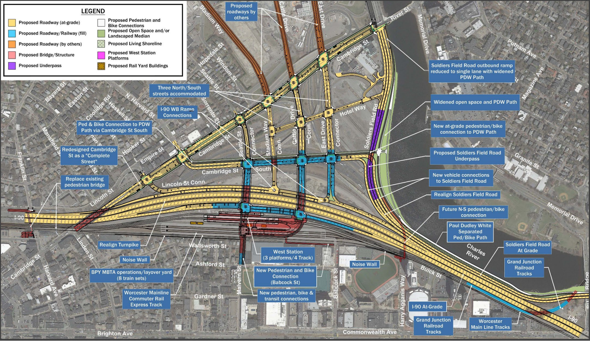
Immediate hottake on de-gunking ^this hot mess^. . .
That's just for starters. The chunky grid still doesn't thrill me, but that's at least a *tolerable* step in the right direction within more or less the current framework.
- Babcock St. is made into a spanning street to East Drive. If the BU DPW garage has to be nuked to elevate the road over the tracks, make it so.
- Cattle Drive Connector doesn't cross the Pike, and is mercilessly road-dieted down to 2 lanes.
- Station and layover trade places to eliminate the slow zone from the banking curve and de-isolate the station from civilization. If the layover is gone (probably), leave what remains of that land as slack space for a future Urban Ring graft-on.
- Station platforms span the Malvern-Babcock block, and there are station entrances on both sides. Do this even if Babcock isn't made into a spanning street so access from BU isn't such an afterthought.
- Figure out what the platform layout is going to be. 3 platforms on 4 tracks is barking insane since adjacent Back Bay, Landsdowne, and Boston Landing only do 2 Worcester Line platform tracks and the Grand Junction shuttle dinky is not happening at whatever grandiose traffic scale this design seems to assume it is. Either make it twin islands (still awfully excessive) so the platform assignments are somewhat coherent, or mirror Boston Landing's single island and flank it with outside passers (preferred).
- Massively compact and/or eliminate the station busways. The 64 and T66 are the only routes that *might* be hitting this station, and the road layout as currently rendered carries enormous time penalties for making the station loop. Honestly, I'm not even sure it's a worth-it capture for the T66 given what a drag all that around-the-blockage is going to be. This is not a big-deal bus hub; why are we designing it like one?
- Consolidate the capacity duplication of Lincoln St. Connector and Cambridge St. South. Just a bonkers number of total E-W lanes 1 block apart.
- Get rid of the excess multi-lane turn lanes. No single road direction should be in excess of 3 lanes at any point. Cambridge St. between Lincoln and N. Harvard in particular is an abomination.
I don't dispute any of the myriad concerns regarding the street grid, but wouldn't the Worcester Mainline CR express track as shown at the southern limit resolve that particular concern? (Certainly it's needlessly taking up space and could probably go away if West Station were better aligned, but for the sake of argument?)... and the big induced curve on the Worcester Line is a giant middle finger to Amtrak trains maintaining track speed on the jaunt out of Back Bay....
Charlie_mta
Senior Member
- Joined
- Jul 15, 2006
- Messages
- 5,150
- Reaction score
- 7,778
I revised the preferred alternative to incorporate some of your ideas, plus make the Pike ramps closer to SFR to minimize traffic over streets and near West Station. The first EB off-ramp from the Pike (to West Station) is bus only. Here's the quick and dirty rendition. I think it's doable with the storage tracks eliminated. I didn't show the necessary narrowing of the overly wide streets, but they need to be, plus break up some more of the larger blocks with additional narrow streets.Immediate hottake on de-gunking ^this hot mess^. . .
That's just for starters. The chunky grid still doesn't thrill me, but that's at least a *tolerable* step in the right direction within more or less the current framework.
- Babcock St. is made into a spanning street to East Drive. If the BU DPW garage has to be nuked to elevate the road over the tracks, make it so.
- Cattle Drive Connector doesn't cross the Pike, and is mercilessly road-dieted down to 2 lanes.
- Station and layover trade places to eliminate the slow zone from the banking curve and de-isolate the station from civilization. If the layover is gone (probably), leave what remains of that land as slack space for a future Urban Ring graft-on.
- Station platforms span the Malvern-Babcock block, and there are station entrances on both sides. Do this even if Babcock isn't made into a spanning street so access from BU isn't such an afterthought.
- Figure out what the platform layout is going to be. 3 platforms on 4 tracks is barking insane since adjacent Back Bay, Landsdowne, and Boston Landing only do 2 Worcester Line platform tracks and the Grand Junction shuttle dinky is not happening at whatever grandiose traffic scale this design seems to assume it is. Either make it twin islands (still awfully excessive) so the platform assignments are somewhat coherent, or mirror Boston Landing's single island and flank it with outside passers (preferred).
- Massively compact and/or eliminate the station busways. The 64 and T66 are the only routes that *might* be hitting this station, and the road layout as currently rendered carries enormous time penalties for making the station loop. Honestly, I'm not even sure it's a worth-it capture for the T66 given what a drag all that around-the-blockage is going to be. This is not a big-deal bus hub; why are we designing it like one?
- Consolidate the capacity duplication of Lincoln St. Connector and Cambridge St. South. Just a bonkers number of total E-W lanes 1 block apart.
- Get rid of the excess multi-lane turn lanes. No single road direction should be in excess of 3 lanes at any point. Cambridge St. between Lincoln and N. Harvard in particular is an abomination. Lengthen a turn lane for longer queues if that's required, but don't make any pedestrian cross 4-5 lanes of traffic just to reach a concrete island.

Last edited:
real_EthanHunt
Active Member
- Joined
- Jul 18, 2019
- Messages
- 265
- Reaction score
- 428
BU would not allow Babcock to be connected. just getting Malvern to connect (for buses only) was a fight.Immediate hottake on de-gunking ^this hot mess^. . .
- Babcock St. is made into a spanning street to East Drive. If the BU DPW garage has to be nuked to elevate the road over the tracks, make it so.
- Massively compact and/or eliminate the station busways. The 64 and T66 are the only routes that *might* be hitting this station, and the road layout as currently rendered carries enormous time penalties for making the station loop. Honestly, I'm not even sure it's a worth-it capture for the T66 given what a drag all that around-the-blockage is going to be. This is not a big-deal bus hub; why are we designing it like one?
the intent would not be to only have those 2 bus lines connecting to the station. the busway and the connectivity it brings is big reason why west station is still part of all of this.
BeyondRevenue
Active Member
- Joined
- Mar 13, 2020
- Messages
- 553
- Reaction score
- 1,157
This already needs a road diet. This ain't Las Vegas. We don't need 40-mule-team turnarounds. As someone said above -- this is a CITY! And as F-Line said above Babcock needs to go all the way through. MASS Dot should build as though that could eventually happen whether BU wills it or not. If we miss an opportunity to stitch this area back together because of a goddamn bus mall or the turf-protecting BU, our grandchildren will be cursing our names on the way to get their oxygen refills and their solar suits.Can we get a place-maker in on this concept? Utile or one of the dozens of other major urban-planning teams that are based locally? Or an international urban-design competition? Bearing witness to another bloated and car-centric traffic-engineer's idea of Boston is so disappointing. As if the Seaport 'streets' as executed didn't prove that already.
Charlie_mta
Senior Member
- Joined
- Jul 15, 2006
- Messages
- 5,150
- Reaction score
- 7,778
I improved my version of the preferred alternative. I narrowed up the street, added some narrow streets to break up the overly large blocks, and added a bus-only/ped/bike Babcock Street bridge over the tracks to connect to West Station and Cambridge Street. Quick and dirty on MS Paint:

Last edited:
Had read a bit ago that Harvard was already considering air rights developer over the new pike here. I would have to think if they do that it would change up the current proposal a bit, hopefully for the better.
F-Line to Dudley
Senior Member
- Joined
- Nov 2, 2010
- Messages
- 9,970
- Reaction score
- 12,304
What buses? There's nothing Yellow Line in the area except for the 64 and an ill-advisedly off-course 66/T66 loop. Coach buses sure as hell aren't going to pit-stop this closely in when South Station is plenty well transit-accessible from BU, Harvard, and Allston. If BU is fighting tooth and nail to keep the street grid disconnected from here it's sure as heck not going to bother to run a university shuttle to that stop. So who are those gigantic busways even for?BU would not allow Babcock to be connected. just getting Malvern to connect (for buses only) was a fight.
the intent would not be to only have those 2 bus lines connecting to the station. the busway and the connectivity it brings is big reason why west station is still part of all of this.
Charlie_mta
Senior Member
- Joined
- Jul 15, 2006
- Messages
- 5,150
- Reaction score
- 7,778
Maybe in anticipation of the Grand Junction RR becoming an LRV line? The way the official preferred alternative railways and station are laid out, a Grand Junction conversion to LRV would fit right into West Station.What buses? There's nothing Yellow Line in the area except for the 64 and an ill-advisedly off-course 66/T66 loop. Coach buses sure as hell aren't going to pit-stop this closely in when South Station is plenty well transit-accessible from BU, Harvard, and Allston. If BU is fighting tooth and nail to keep the street grid disconnected from here it's sure as heck not going to bother to run a university shuttle to that stop. So who are those gigantic busways even for?
But still, even with GL GJ, we should be planning for rail, not busesMaybe in anticipation of the Grand Junction RR becoming an LRV line? The way the official preferred alternative railways and station are laid out, a Grand Junction conversion to LRV would fit right into West Station.
F-Line to Dudley
Senior Member
- Joined
- Nov 2, 2010
- Messages
- 9,970
- Reaction score
- 12,304

West Station is an Overbuilt Mess
Boston has been on a commuter rail infill binge lately; it has opened four stations on the Fairmount Line this decade, with general success, and is now eying the Worcester Line, where the MBTA has …
 pedestrianobservations.com
FWIW...Alon Levy wrote about the hot-mess West Station plan a couple years ago, coming to much the same conclusions about the buses (or lackthereof), storage yard, track/platform layout, Grand Junction RR service problems, and spatial isolation of the site.
I improved my version of the preferred alternative. I narrowed up the street, added some narrow streets to break up the overly large blocks, and added a bus-only/ped/bike Babcock Street bridge over the tracks to connect to West Station and Cambridge Street. Quick and dirty on MS Paint:
I wonder if it's feasible to turn this entire development into a private-vehicle-free one (kind of like the pedestrianized downtown-crossing plaza), and close the roads to only buses, delivery trucks, and bikes. Or maybe only allow cars on one of the east-west streets. Otherwise this area is going to look like Assembly Square on the day that it is built.