There should be as many through streets as possible to distribute flow, and none of them should be large or multi lanes. Alleviate pressure points and have as many cross-territory bus routes with fully dedicated lanes wide enough for light rail conversion, if it ever comes to it, as possibleHere's generally what I have in mind. Downsize the streets, eliminate through streets (except for South Cambridge St), and connect the non-through streets with pedestrian/bike paths (shown as purple lines).
View attachment 46495
(edited to correct mistakes in the layout).
You are using an out of date browser. It may not display this or other websites correctly.
You should upgrade or use an alternative browser.
You should upgrade or use an alternative browser.
I-90 Interchange Improvement Project & West Station | Allston
- Thread starter Matthew
- Start date
Charlie_mta
Senior Member
- Joined
- Jul 15, 2006
- Messages
- 5,150
- Reaction score
- 7,778
I would rather confine the through vehicular traffic to a couple of major streets, and have the side streets for local access only. The problem here is the heavy traffic from/to the Mass Pike connecting to Soldiers Field Road and Cambridge Street. If you have through streets, they will be flooded with this trafficThere should be as many through streets as possible to distribute flow, and none of them should be large or multi lanes. Alleviate pressure points and have as many cross-territory bus routes with fully dedicated lanes wide enough for light rail conversion, if it ever comes to it, as possible
The city does seem to be doing some planning for the area:Cambridge has the largest subway line in the city running up it's spine with multiple stops and is a huge bus hub/has an extensive bus network. This area....does not.
You've drawn a comparison with the Seaport being congested without giving much attention to the reasons people use cars beyond road travel lanes existing.
Unless someone's going to come up with a much more drastic transit proposal than anything remotely proposed to date, if built up/densely like seems to be expected, it's going to be Seaport 2.0 in terms of access challenges and is going to have a lot of people getting there by car by necessity. However, I doubt that transit proposal will cost less in initial capital than asphalt does, so I'm not sure I expect the "construction cost" angle to be compelling.
----------
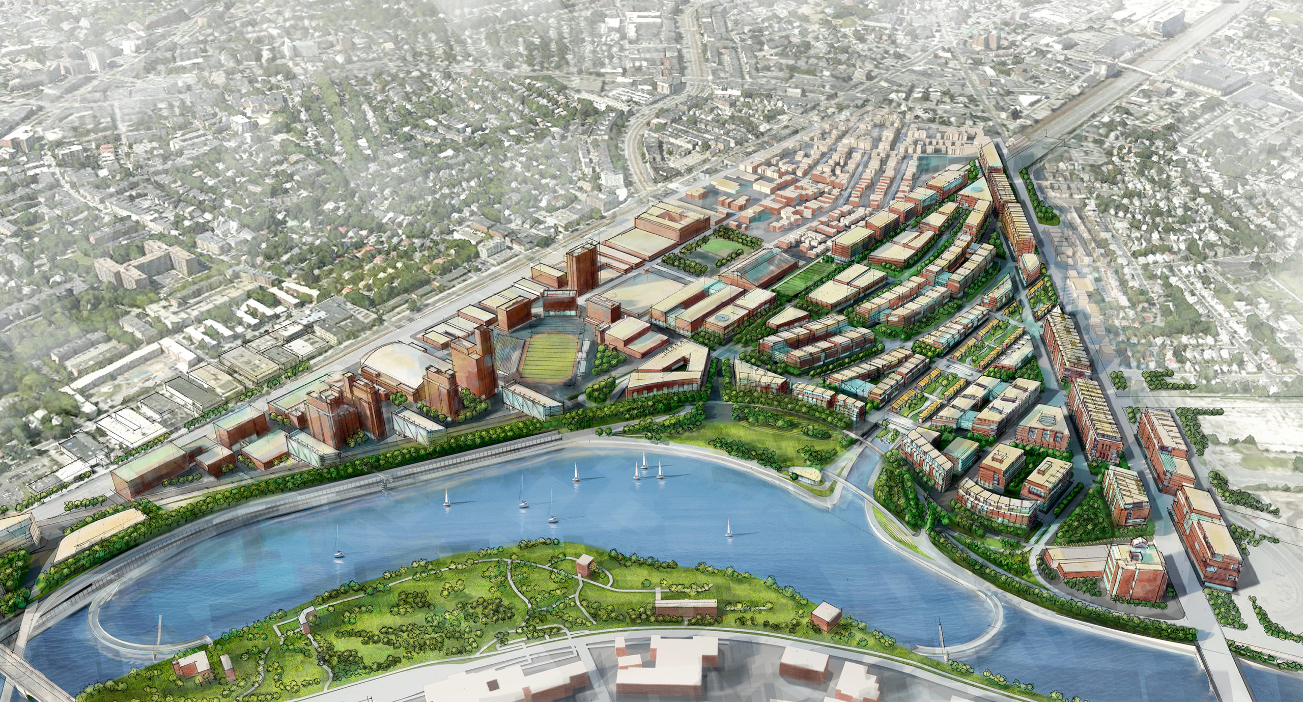
Although I'd also suggest that part of the design problem here is that we're sketching a neighborhood with basically zero idea of what's going to go in it. We know it's valuable land and that's seemingly it.
AFAIK - Harvard has given zero indication of what they'd like to do with the land south of Cambridge St. The zoning looks like it hasn't been touched in 20-30 years and is wildly off-base from what anyone seems to expect would actually go in there when it's developed.
Seemingly no one has even wanted to conceptualize that yet in any way.
This could be a sea of tall buildings with limited transit like the Seaport. No reason you couldn't be putting 30 story buildings in here. You'd certainly need every ounce of road capacity if you're not going to build anything more than a few buses and a few Worcester Line trains for transit. This could be a bunch of college research buildings with little demand for vehicle access.
--------
I'll suggest that a more optimal strategy at this point may be to simply push off the decision about much of it - possibly in a similar fashion as I think @Charlie_mta is getting at. Skip actually building basically everything between Cambridge St South + Cambridge St for now until we've got some actual zoning + development concepts in there.
Beacon Park Yard Regional Framework Plan (BPY Plan) | Bostonplans.org
Active planning initiatives being coordinated by the Planning Department. Find more information inside each initiative, including details, associated files, and contact information.
Allston-Brighton Needs Assessment | Bostonplans.org
Active planning initiatives being coordinated by the Planning Department. Find more information inside each initiative, including details, associated files, and contact information.
I don't know a lot about either of these but they exist?
Teban54
Senior Member
- Joined
- Nov 13, 2021
- Messages
- 1,142
- Reaction score
- 2,856
Interesting bits from the Allston-Brighton needs assessment:The city does seem to be doing some planning for the area:
Beacon Park Yard Regional Framework Plan (BPY Plan) | Bostonplans.org
Active planning initiatives being coordinated by the Planning Department. Find more information inside each initiative, including details, associated files, and contact information.www.bostonplans.org
Allston-Brighton Needs Assessment | Bostonplans.org
Active planning initiatives being coordinated by the Planning Department. Find more information inside each initiative, including details, associated files, and contact information.
I don't know a lot about either of these but they exist?
Future: Western Avenue Transitway Plan
Otherwise, this needs assessment has little to do with transit and/or West Station planning, and more about the needs of existing residents, service providers, housing, etc. Some of the mobility recommendations also talk about non-transit trips like after-school transportation and pedestrian crossings.Getting around inside Allston-Brighton presents issues, a greater proportion of residents reported using a personal car to get to a workplace in
Allston-Brighton than they did so if their workplace was in an adjacent town or in Boston.
The Beacon Park Yard regional framework study does address the West Station area more specifically, but it's still in the beginning stages. The slides did mention a few proposed bus shuttles and the "Grand Junction Line" (which appears to be commuter rail), but didn't mention north-south rail connections:
BACsop
Senior Member
- Joined
- Jun 1, 2019
- Messages
- 1,872
- Reaction score
- 7,861
Interesting bits from the Allston-Brighton needs assessment:
Otherwise, this needs assessment has little to do with transit and/or West Station planning, and more about the needs of existing residents, service providers, housing, etc. Some of the mobility recommendations also talk about non-transit trips like after-school transportation and pedestrian crossings.
The Beacon Park Yard regional framework study does address the West Station area more specifically, but it's still in the beginning stages. The slides did mention a few proposed bus shuttles and the "Grand Junction Line" (which appears to be commuter rail), but didn't mention north-south rail connections:
View attachment 46675
Did they misspell Jackson Square...?
Justbuildit
Senior Member
- Joined
- Nov 27, 2022
- Messages
- 1,088
- Reaction score
- 3,804
Did they misspell Jackson Square...?
And "Backbay" is apparently one word now?
Longfellow
Active Member
- Joined
- Dec 12, 2023
- Messages
- 431
- Reaction score
- 1,031
I feel a little sad that the neighborhood is most certainly going to be called something like "Allston Yard" as if it were a baseball field or something.
Charlie_mta
Senior Member
- Joined
- Jul 15, 2006
- Messages
- 5,150
- Reaction score
- 7,778
I nominate "Allstonville".I feel a little sad that the neighborhood is most certainly going to be called something like "Allston Yard" as if it were a baseball field or something.

I kinda like it when places get weird names like that. There's the connection to history and it confuses new people.I feel a little sad that the neighborhood is most certainly going to be called something like "Allston Yard" as if it were a baseball field or something.
When I first moved to Boston I was excited to see what magical things might be at "Wonderland"
HenryAlan
Senior Member
- Joined
- Dec 15, 2009
- Messages
- 4,473
- Reaction score
- 5,256
It should be named Beacon Yard, but then again, that makes far too much sense.I feel a little sad that the neighborhood is most certainly going to be called something like "Allston Yard" as if it were a baseball field or something.
millerm277
Active Member
- Joined
- Jun 25, 2013
- Messages
- 578
- Reaction score
- 798
While there is the historical connection to the former land use, I'll suggest that:It should be named Beacon Yard, but then again, that makes far too much sense.
- That name has never been widely known to the public so maintaining it doesn't have some sort of useful continuity.
- More usage of names already in use elsewhere in the city invites confusion. Beacon Street is a widely known major artery in a nearby neighborhood....that doesn't go to here.
HenryAlan
Senior Member
- Joined
- Dec 15, 2009
- Messages
- 4,473
- Reaction score
- 5,256
It's subjective, but in terms of place meaning, North Beacon goes quite close to this neighborhood, and I don't think that confuses people. And I'd argue that naming it Beacon Yards would actually increase awareness of the 100 year preceding purpose for the location.While there is the historical connection to the former land use, I'll suggest that:
- That name has never been widely known to the public so maintaining it doesn't have some sort of useful continuity.
- More usage of names already in use elsewhere in the city invites confusion. Beacon Street is a widely known major artery in a nearby neighborhood....that doesn't go to here.
Longfellow
Active Member
- Joined
- Dec 12, 2023
- Messages
- 431
- Reaction score
- 1,031
This is my philosophy as well... but I want something more inspired. Beacon Yard and Allston Yard are in the category of naming every T stop "X Street" or "X Square" to me. Derivative, boring. "Lechmere", "Wonderland", "Back of the Hill". Those names are pure ecstasy. They tell you almost nothing. We need to find something totally arbitrary yet interesting, and then convince the relevant developers to push that name.I kinda like it when places get weird names like that. There's the connection to history and it confuses new people.
When I first moved to Boston I was excited to see what magical things might be at "Wonderland"
My pitch -- we have Allston, and then Lower Allston, what's below Lower Allston? Deep Allston. Imagine the A(rchBoston) branch of the Green Line pull into
the station... Deep Allston. Doors will open on your right. The destination of this train is: Watertown Yard. No smoking please.
I like it!This is my philosophy as well... but I want something more inspired. Beacon Yard and Allston Yard are in the category of naming every T stop "X Street" or "X Square" to me. Derivative, boring. "Lechmere", "Wonderland", "Back of the Hill". Those names are pure ecstasy. They tell you almost nothing. We need to find something totally arbitrary yet interesting, and then convince the relevant developers to push that name.
My pitch -- we have Allston, and then Lower Allston, what's below Lower Allston? Deep Allston. Imagine the A(rchBoston) branch of the Green Line pull into
the station... Deep Allston. Doors will open on your right. The destination of this train is: Watertown Yard. No smoking please.
I do also like something with "Beacon" in it, even just "Beacon Yard." The name actually predates the rail yard, because it was originally "Beacon Trotting Park" or just "Beacon Park," a horse racing track in the 1800s. The railroad bought it up in about 1890, and so its full name became "Beacon Park Yard." Now it'll be a neighborhood, former rail yard, former totting park, so maybe "Beacon Park Yard Village"? Or "Beaconparkyardville"? Only locals will know it's pronounced "Bake'll."
Teban54
Senior Member
- Joined
- Nov 13, 2021
- Messages
- 1,142
- Reaction score
- 2,856
Or how about keeping it simple: Beacon Park?I like it!
I do also like something with "Beacon" in it, even just "Beacon Yard." The name actually predates the rail yard, because it was originally "Beacon Trotting Park" or just "Beacon Park," a horse racing track in the 1800s. The railroad bought it up in about 1890, and so its full name became "Beacon Park Yard." Now it'll be a neighborhood, former rail yard, former totting park, so maybe "Beacon Park Yard Village"? Or "Beaconparkyardville"? Only locals will know it's pronounced "Bake'll."
View attachment 46732
JeffDowntown
Senior Member
- Joined
- May 28, 2007
- Messages
- 5,048
- Reaction score
- 4,226
What do you want to bet that somewhere in the land transfer agreement with Harvard, to develop the area, there is a naming rights clause for the station (as yet unannounced).Or how about keeping it simple: Beacon Park?
Anyone remember the big deal with the Rose Kennedy Greenway, how the City was all hot to assign a name for its opening, and bang, sorry, Ted Kennedy had slipped the name designation into the funding legislation years before.
Longfellow
Active Member
- Joined
- Dec 12, 2023
- Messages
- 431
- Reaction score
- 1,031
Isn't the commuter rail stop almost certainly going to be West Station?
Does kind of beg the question of if we will get an East Station someday. Maybe the proposed underground NSRL station.
Does kind of beg the question of if we will get an East Station someday. Maybe the proposed underground NSRL station.
JeffDowntown
Senior Member
- Joined
- May 28, 2007
- Messages
- 5,048
- Reaction score
- 4,226
I have always assumed West Station is a planning placeholder until a real name is established.Isn't the commuter rail stop almost certainly going to be West Station?
Does kind of beg the question of if we will get an East Station someday. Maybe the proposed underground NSRL station.
I have always assumed that Harvard is going to want to do some "place making" for that massive real estate development, so a new name will emerge related to that. See Boston Landing as an example.
Java King
Active Member
- Joined
- Apr 6, 2007
- Messages
- 986
- Reaction score
- 2,053
I kind of like the name "West Station" since we already have a South and North Station. As for a name for the area: Allston Landing as seen here:I have always assumed West Station is a planning placeholder until a real name is established.
I have always assumed that Harvard is going to want to do some "place making" for that massive real estate development, so a new name will emerge related to that. See Boston Landing as an example.
Allston Landing Reimagined - Paul Lukez Architecture
The I-90 turnpike cuts through Boston’s Allston-Brighton neighborhood, usurping a large swath of land abutting the Charles River, Boston University and Harvard University in a way that separates communities and landscapes. This proposed condensation of the highway would yield large parcels of...
 www.lukez.com
I like Beacon Park, but unless you were a railroad fan, I don't think most people would know the reference.
Something super generic like "Allston Riverbend" LOL
Teban54
Senior Member
- Joined
- Nov 13, 2021
- Messages
- 1,142
- Reaction score
- 2,856
The problem is that, at least in the foreseeable future, West Station will be of very different character from North and South Stations.I kind of like the name "West Station" since we already have a South and North Station.
While the latter two are major railroad hubs connecting multiple regional rail lines and with good rapid transit connections, West Station is a stop on a single regional rail line, whose rapid transit connections may suffer at least in the short term (Grand Junction, potential north-south connection to Harvard, possible BLX much much further out in time). Other than the station site being eyed for substantial development, it really doesn't seem any different from the likes of Porter, Chelsea and Malden Center. (Or arguably even Boston Landing.)
Calling it West Station is honestly quite misleading.