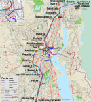
Surface Lines: "Light Rail" and "Streetcar" and "Rapid Bus"
Some pieces of this part of the proposal are largely unchanged from the Transit Forward RI proposal, in particular the
"Light Rail" service, which is basically their proposed north-south LRT line from
Central Falls through Cranston, but truncated to a southern terminal at Sockanosset Cross Road with a transfer to the Light Commuter Rail. This route, a
"Green Line" on my map, mainly travels along wider roads, so my design expects dedicated lanes for much of the length. Even curtailed, this is still a long route at 11 miles, so it will need to be as speedy as possible.
As proposed by Transit Forward RI, I assume "Green Line" stop spacing and frequencies similar to today's R Line.
I distinguish a third category of LRT services as
"Streetcars". These routes are short and concentrated in the core, in part because dedicated lanes will be less available.
A north-south
"Red Line" connects the
Hospital District through Downcity up to Providence Station (following the route of today's DTC), before extending northwest along Smith and Chalkstone to serve the
VA and Roger Williams Medical Centers (major employment destinations), before a short stint of pure street-running to reach a terminus on the edge of the
Providence College campus.
An east-west
"Gold Line" runs from
Olneyville up Broadway to La Salle Square, from which it follows the route of today's 92, increasing frequencies on the lower half of the core segment through Downcity and the Jewelry District, before ending at the
Hospital District transfer terminal.
The "Red Line" and "Gold Line" are meant to be
short, taut corridors, connecting key network nodes and employment locations to distribute riders to key destinations. Because they use the same rolling stock as the much longer "Green Line", they are able to leverage economies of scale in a way that the "Providence Streetcar" proposal of yore could not. This allows them to focus on their primary role:
high volume Last Mile transport.
Finally, the Transit Forward RI proposed
"Rapid Bus" network radiates out across the region, with minor reroutes as needed to offer direct transfers to Regional Rail and "Blue Line" services for faster journeys.
Full Network
~~~
So, this is "If I were God" territory, for sure. But I actually don't think it's
too far out of the realm of possibility. A lot of these pieces are already on the table:
- A lengthy (and therefore rolling stock-heavy) LRT line
- High-freq layered regional rail
- Short streetcar routes in the core (albeit different routes than described here)
In terms of capital costs, the "Blue Line" obviously eats up the lion's share of the pie. An actual elevated over 95 would likely be prohibitively expensive. But I'm not sure an elevated would actually be necessary. The urban canyon gouged out by the highway between La Salle Square and the 195 interchange is actually quite wide: 8+ highway lanes (!), ~3 lanes per service road on each side, plus anywhere from 30 to 100 feet (horizontally) of embankment. And the open cut that the highway sits within is (I believe) consistently at least 200 feet wide, which is more than enough room to fit 2 LRT tracks, a center platform, an 8 lane highway with shoulders and room to spare:
(Alternatively, the "Blue Line" could sit at street level, but I would really prefer to avoid that -- the whole point is to create a high-freq service that zips along, and dealing with the at-grade crossings I think creates too much of a barrier to that.)
With some reallocation of space within the "I-95 Valley", it should be possible to fit an at-grade LRT ROW. That reduces our "crazy engineering" scope to two segments: 1) Portal to Exit 37 Interchange, and 2) the 195 Interchange. (There's also the question of what to do between the Hospital District and the junction with the NEC, but space is less constrained along there, so I'm less concerned.)
For that northern segment along Memorial Boulevard, it's about .75 miles that needs to be traversed, which is long but isn't
that long. Particularly if you can build off of the existing tunnel, then the question is potentially reduced to getting through the spaghetti at the Exit 37 Interchange, which certainly won't be
easy, but could be worse. At the 195 Interchange, there's enough open space on the western side of the highway that I think you could weave something through there with some modest landtakings and/or road-takings (e.g. Crary St).
So... is this a "If I Were God" pitch? Absolutely. But, I do believe this proposal offers a path toward a reimagined Providence where it is truly possible to live car-free. With this
one massive investment of a rail connection between the East Side Train Tunnel and the Hospital District, the entire transit network could be transformed -- and with it, potentially the city itself.
tl;dr: Providence should build a

into Route 95 so that the

can go as fast as


to connect to the

and the

and the

and to

. It should use this route to connect the abandoned

to the

near the


to create a new

across the region to fill in gaps in the current infrastructure network.


