If You Were God/Goddess | Transit & Infrastructure Sandbox

I wasn't meaning my comment as a put-down, at all, so I'm sorry if it came out that way. I was trying to say that, in some places on Earth, this kind of transit expansion idea would be seen as exactly that: a growth tool. So, in other political contexts, an idea like this would be a lot closer to a "reasonable" pitch.
 
I keep seeing extending T service out to the burbs. How about densifying Dorchester, Roslindale and Mattapan? If the red line can be extended to Alwife, this could be reasonable. But I put it here instead of reasonable pitches because building tunnels$ just doesn't seem feasible these days. Also, I think its a shame that Franklin Park and Arborway is not on a subway so...
Extending the Red line from Ashmont to Forest Hills under Gallivan Blvd and Morton St and ending at a new storage yard at the old Forest Hill station. Extending the orange line thru Roslindale to Mattapan under Cummings and taking over of the red line extension yard with a small yard and loop. The red line extension can be extended over River St and take over the Auto Sales lot for a new station.
View attachment 34755

View attachment 34756
View attachment 34757
Oh huh, this is an interesting idea I hadn't seen before. I've crayoned extending an HRT-converted Mattapan Line up to Roslindale Village, but I hadn't considered an alignment from Ashmont via Gallivan and Morton. In general, I'm pretty skeptical of dogleg extensions like this; they combine radial and circumferential service in ways I think are often less efficient, and they create long roundabout rides. But the idea of a pair of doglegs creating multiple cross-Dorchester corridors is thought-provoking.

That being said, you're suggesting (I think) about 5.7 miles of new tunnels here; that same distance of tunnel is just about what it would take to build a new subway that runs from the Pleasant Street Portal all the way through Nubian, Warren St, and Blue Hill Ave all the way to Mattapan, potentially allowing you to extend the Green Line all the way through Dorchester without killing its reliability.

Of course, that's not so much "Imagine that Boston were Madrid," as "Imagine that Boston were LA"!
 
Suppose the order came down on high that rail lines were going to be built along highway ROWs, so just make it work. Obviously, highway and rail ROWs are… mediocre fits for each other, so it would take some effort to make work.

What, in general, would be the best way to get it done? Elevate the rail line above the highway so the slopes and curves can be smoothed? Tunnel under the highway? Big dig the highway and let the rail have the surface?
Elevated rail alongside an expressway is usually far less expensive than tunneling either the railway or the roadway. Seattle has built, and is building, some elevated light rail lines alongside I-5 and other freeways. Of course in the Boston area, there would be opposition from NIMBYs to the elevated rail lines near their homes. Seattle doesn't seem to have that NIMBY problem, at least on the scale that the Boston area experiences.
 
Yeah, I would run elevated rail over the highway. (Over, alongside, in the median, whichever is appropriate.) When possible it would be preferable to locate stations outside of the highway ROW -- rail stations should be near where people live, work, or otherwise want to go, and in general highways drive people away, so you'd be kneecapping potential walkshed ridership if the station is isolated within a highway ROW. (There are plenty of examples of stations like this, so it definitely is done, I'm just saying that I think it's a bad idea.) So, run the tracks mainly along the highway, but try to locate paths that can briefly divert the rail ROW outside of the highway.
 
Yeah, I would run elevated rail over the highway. (Over, alongside, in the median, whichever is appropriate.) When possible it would be preferable to locate stations outside of the highway ROW -- rail stations should be near where people live, work, or otherwise want to go, and in general highways drive people away, so you'd be kneecapping potential walkshed ridership if the station is isolated within a highway ROW. (There are plenty of examples of stations like this, so it definitely is done, I'm just saying that I think it's a bad idea.) So, run the tracks mainly along the highway, but try to locate paths that can briefly divert the rail ROW outside of the highway.

Definitely. Chicago has (or had, at least) a fondness for the HRT-in-median approach, which added notably-longer walks through lower-density areas than their older elevated lines (which were usually more convenient...at least when they weren't as bogged-down in track work as the T...)
 
With modern concrete viaducts elevated transitways are actually pretty nice imo (vancouver skytrain comes to mind) and it gives riders an amazing elevated view over the city that is a million times more enjoyable than riding in a dark subway tunnel. I know Boston has an aversion to elevated lines due to the past experience with 20th century creaky, rusty, shadowy, elevated lines screeching through neighborhoods, but hopefully now that new examples like seattle or even glx through east cambridge are built peoples minds will start to change.

That being said where do you see a highway in the Boston area that would even need an elevated transit line? The pike and 93s already have lines running next to them which would be better served by electric multiple units for regional rail. Rt1 passes under the harbor so that would be more trouble than its worth. Rt2 starts right at the end of alewife station, but the minuteman right of way already exists next to it with a better catchment area. That really only leaves 93 north past assembly and the i95 beltway. I guess you could also throw in 203 + the arborway and jamaicaway as an inner belt line light rail.

-93 north past assembly would follow pretty close to glx with one half of its catchment area taken up by the mystic river, before turning into downtown medford, and then pretty quickly hitting the fells reservation. Not the greatest use of limited resources though hitting downtown medford would definitely be a huge improvement, so overall not the greatest but not completely bad either.

-i95 beltway would be a massive upgrade to the system, but would only be viable as an electric multiple unit line after regional rail/electrification is implemented. This would make the most sense imo being electric multiple units acting as a node of regional rail due to the long distance and spaced out stations.

-203, arborway, jamaicaway light rail could be an inner belt line that could use elevated viaducts along 203 up to about blue hill ave and then median running through the arborway. This isnt a real “highway” though so it would receive enormous pushback and would have almost no chance of happening.

Is there anything else that sticks out that would make sense for building an elevated transit line next to a highway? It seems that there really arent any obvious options that could be taken advantage of, that dont already have some sort of existing line or a duplicate line close by. I would love to see a radial regional rail line built along i95 at some point way into the future, but thats really outside of the scope of what the premise was of an elevated rapid transit line along a highway.
 
-i95 beltway would be a massive upgrade to the system, but would only be viable as an electric multiple unit line after regional rail/electrification is implemented. This would make the most sense imo being electric multiple units acting as a node of regional rail due to the long distance and spaced out stations.

I'm not sure you need to even go the whole hog. Places like Burlington, with no rapid transit connection, could have their development trajectories changed massively with a partial-circumference line that links it to downtown Reading (Orange Line extension, God willing), Mishuwam or Anderson (regional rail + commuter trains to New Hampshire, and long-distance trains to Maine). Here's the Census On the Map analysis of where workers in that corridor commute from to private primary jobs:

1681823285947.png


That looks like an opportunity to leverage an electrified Lowell Line with stops added in Woburn (Montvale Ave?) to anchor a new suburban bus network. Maybe you'd need to continue the circumferential line I describe up Middlesex Turnpike to anchor the other end of those bus lines since the somewhat-squirrely roads up there would make for very long routes, mileage-wise.
 
I would love to see a radial regional rail line built along i95 at some point way into the future, but thats really outside of the scope of what the premise was of an elevated rapid transit line along a highway.

My apologies for not being clearer - I should have specified I wasn’t just referring to rapid transit in the city. Your idea is exactly what my premise was. Regional rail along the highways, particularly along routes that are not served/underserved by the Commuter Rail and/or Amtrak.

95/128, 495/44, heck, route the Acela along 95 in those troublesome CT areas.

Another option that could possibly create some opportunities are electrical transmission line right of ways. I found this map that shows the different right of ways. I havent had time to really look around and compare the transmission ROWs to rail ROWs, but there could possibly be something in there.

https://www.arcgis.com/apps/instant...x.html?appid=895faaf79d744f2ab3b72f8bd5778e68
 
As it happens, I have a couple of crayon maps that I've been tinkering with that use some of the ideas discussed here. I'll have to try to spruce those up this weekend and post...
 
I could see an elevated along Bus route 1
There are several wide streets and boulevards in the Boston inner metro area that would make sense for elevated light rail. One that i came up with is an Urban Ring LRV line elevated along Revere Beach Parkway in Everett. The line would connect to the Grand Junction RR ROW in Cambridge via Sullivan. Green is surface route and yellow is elevated. Circles are stations:
50740579923_a9cfef335f_b.jpg


Another route for elevated LRV is Blue Hill Ave north from Mattapan Square, then up Seaver Street and Columbus Ave to the Jackson Sq OL station.
 
So. The problem in Providence is that it has multiple pieces of rail infrastructure that almost form the bones of a strong network, but which just slightly miss the mark.

Consider:

1682791650457.png


Purple is the active Northeast Corridor. Red is the abandoned East Side Train Tunnel, plus the freight lines in East Providence. Blue are the freight tracks running into the Port of Providence (connected, I believe, to a not-quite-abandoned street-running track along Allens Ave). The circles are employment centers, which I've simplified and labeled below:

1682791851734.png


Aside from Brown University and the cluster of centers around the train station, the rail infrastructure practically goes out of its way to avoid the major employment centers, in particular the Hospital District just south of 195:

1682791945805.png


(In fact, the circular path of the NEC orbits a centerpoint roughly located at RI Hospital -- staying pretty consistently 1.5 miles away. Like I said, it's as if the ROW is actively avoiding serving the hospital.)

Layering multiple services on the NEC -- e.g. 2 tph MBTA Regional Rail to Boston, 2 tph RIPTA Rhode Island Commuter Rail, 2 tph RIPTA short-turns -- to create a high-frequency spine from Pawtucket through Providence to, say, TF Green Airport has become a pretty standard idea among circles like ours. Peter Brassard's 2012 proposal is a good example.

The East Side Train Tunnel itself is a tempting target for transit planning; it goes right under Brown University (one of the state's largest employers), and the tunnel itself is pretty much totally intact. In fact, one iteration of the Transit Forward RI 2040 study included repurposing the East Side Train Tunnel for an east-west light rail line connecting to Olneyville via Broadway. This complements a lengthy north-south LRT line running from Central Falls to CCRI in Warwick.

[insert map here, the forum software is fighting me on this one]

Now, I love me some LRT. But. First of all, that proposed north-south route is long -- more than 14 miles, and as far as I can tell, operating either in mixed traffic or at best dedicated lanes. There are very few LRT lines (at least in North America) that I know of that are that long -- mostly in Los Angeles -- and those at least have significant stretches of dedicated ROW. The stretch from CCRI to Downtown currently takes the 21, running along a similar route, a total of 45 minutes. By contrast, driving takes about 20 minutes, and will offer a one-seat ride to your destination (and saving the additional time of transferring at Kennedy Plaza).

Now, don't get me wrong -- I'd wager that route will have stunningly high ridership, as it strings together parts of the R Line, the 20, 21, and 22, the first two of which are among RIPTA's highest ridership routes.

But, Rhode Island's (and even Providence's) transit usage remains relatively low: 3% and 8% respectively. By comparison, Boston's transit usage sits at about 34%. And to me, that seems unlikely to change as long as driving is consistently so much faster for almost all journeys.

(Part of the problem is the 20 minute frequencies that are common even on the highest-frequency routes: if you miss the bus -- not uncommon due to reliability issues -- and you need to wait another 20 minutes, and then ride for another 5-15 minutes, at that point you are often in territory where it would be equally fast to walk. And now imagine that you have a car as an alternative: take a 30 minute walk, or spend 30 min waiting for and on the bus, or drive there in 10 minutes; it's an easy choice.)

A 14-mile LRT line from Central Falls to CCRI is ambitious and bold, and well worthwhile. But it seems less likely to enact mode shift. Over distances like that, transit should be limited stop and higher speed -- fundamentally incompatible with street-running.

By that same token, I think that the proposal for an East-West LRT Line underutilizes the East Side Train Tunnel. This is a piece of infrastructure that can be higher speed with limited stops; pairing it with what would basically be a streetcar running down Broadway (itself a lovely idea, but a very different character of transit) seems ineffective. Moreover, if you're going to serve the East Side with streetcars, why not use the existing Bus Tunnel at much lower cost? (And provide better service to Wayland Square to boot.)

So, what am I getting at here?
  • I want to effect mode shift in Providence and Rhode Island, by making transit genuinely competitive with SOV journeys and making it possible if not desirable to live car-free in the region
  • I want longer distance services to run at higher speeds with fewer stops in order to remain competitive with driving
  • I want to reserve surface lines for shorter distances
  • I want to bring transit to Providence's major employment centers, in particular the Hospital District
Where do "elevateds over highways" come into the picture?

Stay tuned...
 

Attachments

  • 1682792356847.png
    1682792356847.png
    2 MB · Views: 63
Let's return to that simplified diagram of existing infrastructure and employment centers:

1682805544616.png


Assuming, for the sake of crayoning, that both the East Side Train Tunnel and the freight tracks to ProvPort can be utilized for new rail transit, what we need is some way to connect the two, while serving the Hospital District along the way.

And it just so happens that the canyon created by the construction of I-95 does almost exactly that:

1682805701288.png


Now, you still need to get from the East Side Train Tunnel's portal at Thomas St to 95, but there seem to be potential options there (including for example an El over Memorial Boulevard, or a tunnel alongside the existing mainline ROW between the train station and the highway).

So. Here is Riverside's Moonshot Transit Plan for Rhode Island:

Regional Rail
  • MBTA Regional Rail service TF Green - Boston (2-4 tph)
  • RIPTA metro services Woonsocket - Wickford Junction (1-2 tph)
  • RIPTA commuter rail services Worcester - Providence and Westerly - Providence (1 tph each)
  • Amtrak peak direction express commuter service between South County and Boston (1 or 2 round trips per day)
Targeting a combined frequency of 4-8 tph between Pawtucket/Central Falls and TF Green Airport. All trains make all stops except Amtrak, which runs express north of TF Green stopping only at Providence
From south to north:
  • Westerly
  • Kingston
  • Wickford Junction
  • Davisville for Quonset Point
  • East Greenwich
  • Apponaug
  • Cranston/Park Ave
  • Olneyville
  • Providence
  • Silver Spring/Smithfield Ave for Miriam Hospital
  • Pawtucket/Central Falls
  • Berkeley (Cumberland)
  • Manville
  • Woonsocket
  • potential intermediate stops in MA
  • Worcester

"Light commuter rail"

This is the "Big Idea". Linking the East Side Train Tunnel and the Port of Providence tracks using an elevated over 95, this creates a second spine of service that directly serves both Downcity and the Hospital District, and which provides a trunk line for longer distance light rail feeder services from the more distant suburbs -- hence the term "light commuter rail", to acknowledge both the LRT rolling stock and the greater distances. For convenience's sake, I'll call this route the "Blue Line", but there are lots of branding options.

1682815416713.png


The use of a fully dedicated ROW ensures high speeds and creates a competitive alternative to driving (especially when integrated into the surface network, see below). At an average of 25 mph (the average speed of the LA Metro's A Line over a similar distance and number of stops), this route could clear the 2.25 miles between Thayer St and RI Hospital in 5.5 minutes; the 1.6 miles from the Providence Station to RIH could be cleared in just under 4 minutes.

But where this Elevated would really save time is on journeys to the Hospital District from Providence's southern and western neighborhoods (and beyond), as well as journeys from East Providence and the East Bay: transfer points along 95 mean that riders on radial bus routes don't need to traverse all the way into Downcity and transfer to a DTC route for their last leg -- they instead can transfer at 95 and head directly to the Hospital District. Riders from East Providence (which currently has no direct routes to the Hospital District) likewise are able to skip the transfer to the DTC.

For example, a journey from Olneyville to RI Hospital today takes 28 minutes at rush hour; the drive takes 10 minutes, maybe 15 if there is traffic. With the Elevated, the transit journey becomes competitive: ~6 min to the Elevated, let's say 5 minutes for the transfer and wait, then 3 min on the Elevated to RIH, for a total of 14 min. That wait time obviously is a critical variable, but the core segment between Gano St and the Hospital District is short enough that a high frequency short-turn shuttle service pinging back and forth between them could be run with a small number of trainsets.

Proposed "Blue Line" station locations include the following (with optional stations in italics):
  • Gano St for Wayland Sq
  • Thayer St for Brown University
  • Exchange St for Downcity and Providence Station (see below)
  • LaSalle Sq at Atwells/Broadway for Convention Center
  • Cathedral Sq at Westminster/Broad
  • Hospital District
  • somewhere in South Providence, possibly near the intersection of Broad & Prairie
Note: building a good transfer to Providence Station is hard. You can get a closer transfer using a horseshoe-shaped alignment that cuts over the canal to Park Row West and then hooks around to the station and then back down Exchange St; or instead of Exchange St you could cut across Station Park or Gaspee St to reach the highway that way. You also possibly could widen the current tunnel to add 2 tracks.

On this crayon map, I've opted for a straighter alignment that puts a station at Exchange St's bridge over the river; I would then build a semi-protected walking connection to the train station itself. In addition to being a straighter and speedier alignment, this location also provides better access to Downcity; from there, you can utilize the wider open space above Memorial Boulevard for the short connection needed to reach the I-95 ROW.

In terms of branches, there's a lot of flexibility and possibility here, particularly at the northeastern end. What I currently envision is three mid-low frequency branches (15 min headways) that fan out across East Providence, to Rumford, Wampanoag Plaza, and Seekonk Square via the 195 alignment.

1682818811219.png


I've indicated the proposed "Rapid Bus" routes above to show how they would interact with the "Blue Line" branches, providing transfer points for speedy journeys into Downcity and the Hospital District. East Providence sits in a sorta weird level of density with an odd mix of walkability but low-ish population, and so I think idea of branching out for more diffuse lower frequency service makes sense. On the other hand, this could also be built as a single line to Wampanoag Plaza to maximize frequencies for easy transfers at the terminal and at Broadway. (The ROW between Broadway and the Plaza isn't perfectly intact, but it's not terrible.)

At the southwestern end, my big objective is to reach CCRI to relieve that surface line of the need to travel quite so far. Nearby are the Warwick Mall and Rhode Island Mall, as well as Kent Hospital -- destinations we know are popular with riders, and which are easily accessible from the highways, providing PnR options with one-seat rides to the Hospital District, Downcity, and Brown University, more conveniently than the mainline NEC services can.

95 and then a combination of 95 and the freight tracks provide a path from the Hospital District back to the NEC, where transfers can be available at the Park Ave station in Cranston (again, affording South County commuters a more direct connection to employment destinations). Beyond that, we are lucky to discover a nearly unencumbered ROW that runs almost entirely without interruption all the way to the Warwick Mall -- the once and former Pawtuxet Valley Railroad.

This branchline has not seen passenger services in about 100 years, and most of its route is on the edge of residential neighborhoods, and passing along office parks and the Rhode Island Department of Corrections complex. There are few places where a station would be warranted, and I argue that's a good thing in this case: this is meant to be a longer distance, higher speed service, bringing riders quickly to and from the hubs at the malls and CCRI.

Once the ROW arrives at Warwick Mall, it would need to snake over the mall's lot and over 295 before reaching the access road to CCRI; I would suggest widening that ROW enough to give dedicated space to the tracks. After stopping at CCRI, the "Blue Line" snakes through the woods to emerge at the back of Kent Hospital, where it terminates.

1682882891857.png


1682882921436.png


The high frequencies needed in the core would likely be unnecessary this far out, so probably some branches would short-turn closer to Providence, possibly at Cranston (to maximize frequencies at the transfer point).

(continued below)
 
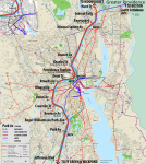
Surface Lines: "Light Rail" and "Streetcar" and "Rapid Bus"

Some pieces of this part of the proposal are largely unchanged from the Transit Forward RI proposal, in particular the "Light Rail" service, which is basically their proposed north-south LRT line from Central Falls through Cranston, but truncated to a southern terminal at Sockanosset Cross Road with a transfer to the Light Commuter Rail. This route, a "Green Line" on my map, mainly travels along wider roads, so my design expects dedicated lanes for much of the length. Even curtailed, this is still a long route at 11 miles, so it will need to be as speedy as possible.

As proposed by Transit Forward RI, I assume "Green Line" stop spacing and frequencies similar to today's R Line.

I distinguish a third category of LRT services as "Streetcars". These routes are short and concentrated in the core, in part because dedicated lanes will be less available.

A north-south "Red Line" connects the Hospital District through Downcity up to Providence Station (following the route of today's DTC), before extending northwest along Smith and Chalkstone to serve the VA and Roger Williams Medical Centers (major employment destinations), before a short stint of pure street-running to reach a terminus on the edge of the Providence College campus.

An east-west "Gold Line" runs from Olneyville up Broadway to La Salle Square, from which it follows the route of today's 92, increasing frequencies on the lower half of the core segment through Downcity and the Jewelry District, before ending at the Hospital District transfer terminal.

The "Red Line" and "Gold Line" are meant to be short, taut corridors, connecting key network nodes and employment locations to distribute riders to key destinations. Because they use the same rolling stock as the much longer "Green Line", they are able to leverage economies of scale in a way that the "Providence Streetcar" proposal of yore could not. This allows them to focus on their primary role: high volume Last Mile transport.

Finally, the Transit Forward RI proposed "Rapid Bus" network radiates out across the region, with minor reroutes as needed to offer direct transfers to Regional Rail and "Blue Line" services for faster journeys.

1682886534489.png


Full Network

1682886998973.png


~~~

So, this is "If I were God" territory, for sure. But I actually don't think it's too far out of the realm of possibility. A lot of these pieces are already on the table:
  • A lengthy (and therefore rolling stock-heavy) LRT line
  • High-freq layered regional rail
  • Short streetcar routes in the core (albeit different routes than described here)
In terms of capital costs, the "Blue Line" obviously eats up the lion's share of the pie. An actual elevated over 95 would likely be prohibitively expensive. But I'm not sure an elevated would actually be necessary. The urban canyon gouged out by the highway between La Salle Square and the 195 interchange is actually quite wide: 8+ highway lanes (!), ~3 lanes per service road on each side, plus anywhere from 30 to 100 feet (horizontally) of embankment. And the open cut that the highway sits within is (I believe) consistently at least 200 feet wide, which is more than enough room to fit 2 LRT tracks, a center platform, an 8 lane highway with shoulders and room to spare:

1682888414393.png


(Alternatively, the "Blue Line" could sit at street level, but I would really prefer to avoid that -- the whole point is to create a high-freq service that zips along, and dealing with the at-grade crossings I think creates too much of a barrier to that.)

With some reallocation of space within the "I-95 Valley", it should be possible to fit an at-grade LRT ROW. That reduces our "crazy engineering" scope to two segments: 1) Portal to Exit 37 Interchange, and 2) the 195 Interchange. (There's also the question of what to do between the Hospital District and the junction with the NEC, but space is less constrained along there, so I'm less concerned.)

For that northern segment along Memorial Boulevard, it's about .75 miles that needs to be traversed, which is long but isn't that long. Particularly if you can build off of the existing tunnel, then the question is potentially reduced to getting through the spaghetti at the Exit 37 Interchange, which certainly won't be easy, but could be worse. At the 195 Interchange, there's enough open space on the western side of the highway that I think you could weave something through there with some modest landtakings and/or road-takings (e.g. Crary St).

So... is this a "If I Were God" pitch? Absolutely. But, I do believe this proposal offers a path toward a reimagined Providence where it is truly possible to live car-free. With this one massive investment of a rail connection between the East Side Train Tunnel and the Hospital District, the entire transit network could be transformed -- and with it, potentially the city itself.

tl;dr: Providence should build a 🚊 into Route 95 so that the 🚊 can go as fast as 🚗🚙🚗 to connect to the 🏥 and the 🎓 and the 🚉 and to 🏙️. It should use this route to connect the abandoned 🚇 to the 🛤️ near the 🚢🚢🚢 to create a new 🚈 across the region to fill in gaps in the current infrastructure network.
 
Stations in highway medians are generally terrible for transit. They are LOUD and unpleasant to stand when waiting, and it is very hard to create a pleasant and safe walking route to and from them. I would highly recommend against them. It is much better for stations to be in areas where pedestrians are already present, around businesses and housing.
 
Stations in highway medians are generally terrible for transit. They are LOUD and unpleasant to stand when waiting, and it is very hard to create a pleasant and safe walking route to and from them. I would highly recommend against them. It is much better for stations to be in areas where pedestrians are already present, around businesses and housing.
In general, I agree with you on this point (which I hope goes without saying). I see a few reasons why this situation is potentially an exception. (And, to be clear, at most we are talking about Cathedral Sq and La Salle Sq being in medians; the Hospital District station would likely be in the parking lot opposite RIH.)

First, the "ideal" crayon build would have these stations elevated above street level, at least two stories above the highway, which would mitigate some of the rider hostility you describe.

Second, we don't literally have to put the stations in the highway median. My diagram was just meant to illustrate that the overall width of the highway's open cut is more than enough room to fit the various lanes, tracks, and platforms, in some configurations TBD. Insofar as I had looked into the particulars, I was imagining a station on the western side of the highway rather than in the middle of it; you could even look at a brief cut-and-cover under the parallel service roads to place the station in a subway.

The point about walksheds is well-made and is I agree a downside of the proposal. But the primary objective of this new rail line is to provide a speedy transfer service operating between major employment hubs, in order to effect mode shift across the region. I'm willing to sacrifice some walkability for that.

But, to my final point: where would the alternative be? If there's another alignment that could be built, I'm all ears! But in general Providence's streets are relatively narrow, and to make matters worse, the street grid in Downcity is basically aligned on the worst possible offset for building a link to Rhode Island Hospital (unless you want to deep tunnel underneath lots of buildings to cut diagonally across blocks). The only possibility I see is Dyer St, but that relocates the transfer point away from the western surface lines, which seems less favorable to me.

I agree that it's a significant downside to use the highway alignment, but I think there's still merit when looked at holistically.
 

Back
Top