
If You Were God/Goddess | Transit & Infrastructure Sandbox

With the discussion of new landfill, I finally remembered to get from the library Gaining Ground by Nancy Seashoals. I'm just browsing through, but I highly recommend it to anyone interested in landfill in Boston. It is an extremely detailed history of Boston's expansion, practically parcel by parcel.

I think a part of it is interesting because filling land is way more expensive than just using existing land, so it was mostly only done when there was some really compelling need. Probably the bulk of it was done for maritime reasons like building out successively larger wharfs, or giant Navy expansions for wartime shipbuilding. A lot of tidal flats got filled in because the town polluted them and they became stinking and dangerous. Transportation right-of-ways, especially railroads had no way to get in to the city except embankments built over tidal flats. The airport was put where it was put, then had to gradually accommodate bigger and bigger planes. There were a bunch of tidal mill damns that didn't work well, and their reservoirs got filled in.

Back Bay and South End are pretty notable exceptions for creating new land just for residential space. But that was at a time when there was no other option but to walk to downtown, and so it was likely much more important that Boston build more land next to downtown. Purely recreational areas exist, like the Esplanade, but are relatively rare. It was just too expensive.

With those categories in mind, and all the ways the city has changed, it's hard to image there is a ton of new land to build. Other than a climate-change-related dyke.

(I know the original question assumed infinite money, but some of the constraints are pretty interesting, too)
 
With the discussion of new landfill, I finally remembered to get from the library Gaining Ground by Nancy Seashoals. I'm just browsing through, but I highly recommend it to anyone interested in landfill in Boston. It is an extremely detailed history of Boston's expansion, practically parcel by parcel.

I think a part of it is interesting because filling land is way more expensive than just using existing land, so it was mostly only done when there was some really compelling need. Probably the bulk of it was done for maritime reasons like building out successively larger wharfs, or giant Navy expansions for wartime shipbuilding. A lot of tidal flats got filled in because the town polluted them and they became stinking and dangerous. Transportation right-of-ways, especially railroads had no way to get in to the city except embankments built over tidal flats. The airport was put where it was put, then had to gradually accommodate bigger and bigger planes. There were a bunch of tidal mill damns that didn't work well, and their reservoirs got filled in.

Back Bay and South End are pretty notable exceptions for creating new land just for residential space. But that was at a time when there was no other option but to walk to downtown, and so it was likely much more important that Boston build more land next to downtown. Purely recreational areas exist, like the Esplanade, but are relatively rare. It was just too expensive.

With those categories in mind, and all the ways the city has changed, it's hard to image there is a ton of new land to build. Other than a climate-change-related dyke.

(I know the original question assumed infinite money, but some of the constraints are pretty interesting, too)
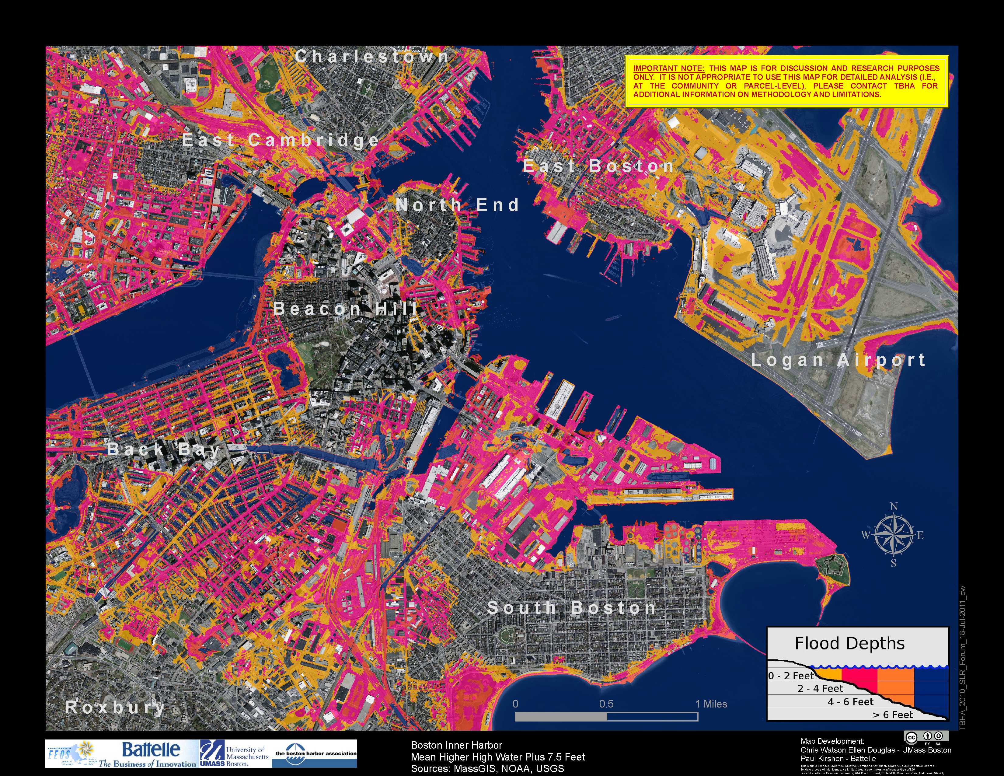
It's also important to note that Boston's landfilled land correlates highly with areas of maximum flood risk, with the original land mass correlating with areas of lowest risk. I much doubt we're going to be in a mood to take on more of that risk until we've come up with a reliable solution for protecting all of our existing land from inundation.

MHHW075_InnerHarbor_TheBostonHarborAssociation_2010_SLR_Forum_CreativeCommons_BY_SA_20110728.jpg


1785442737810.png
 
NEW ENGLAND INTERCITY RAIL NETWORK

What if we expanded on the concept of shorter, state-sponsored Amtrak routes and had the MBTA run a series of intercity routes throughout New England? These routes would be served by vehicles closer to Amtrak trains than commuter trains, to provide comfort for the rides which would be longer than commuter rail / regional rail routes. Assume these would run diesel trains, and would operate in addition to the commuter rail network. It wouldn't make sense to do this until the commuter rail is upgraded into a fully-electrified, regional rail network with EMUs running under the wire. North-South Rail Link would help, of course, but isn't needed for this to work. This would expand and formalize a type of passenger rail between commuter rail and long-distance, cross-country trains.

Note: The Northeast Corridor is a unique rail service in the American context, and would not be considered a part of this new intercity system. It is included purely for reference, highlighted in green.

Routes:

1. Boston, MA to Kittery, ME:
This would restore train service to Portsmouth, NH, as well as the nearby shopping hub of Kittery, across the border in Maine. This service would run on an extended Newburyport line, serving as an express version of that commuter service, stopping in Lynn, Salem, and Ipswich along the way.
Rail Transfers(Rapid Transit): Orange and Green Lines at North Station.
Rail Transfers(Regional): Newburyport/Rockport Line at North Station, Lynn, Salem, Ipswich, and Newburyport. Haverhill, Lowell, and Fitchburg Lines at North Station.
Rail Transfers(Intercity): Brunswick and Greenfield Line at North Station.
Rail Transfers(Long-distance): none

2. Boston, MA to Brunswick, ME: This, of course, is the popular Downeaster service. Not much more to say about it!
Rail Transfers(Rapid Transit): Orange and Green Lines at North Station.
Rail Transfers(Regional): Haverhill Line at North Station, Anderson/Woburn, and Haverhill. Newburyport/Rockport, Lowell, and Fitchburg Lines at North Station.
Rail Transfers(Intercity): Kittery and Greenfield Lines at North Station.
Rail Transfers(Long-distance): none

3. Boston, MA to Greenfield, MA: This is a modified Northern Tier concept, terminating in Greenfield rather than North Adams since the cost of upgrading the Hoosac Tunnel isn't compelling, even in God Mode!
Rail Transfers(Rapid Transit): Orange and Green Lines at North Station.
Rail Transfers(Regional): Fitchburg Line at North Station, Porter, Waltham, Lincoln, Concord, South Acton, Littleton/495, North Leominster, and Fitchburg. Newburyport/Rockport, Lowell, and Haverhill Lines at North Station.
Rail Transfers(Intercity): Kittery and Brunswick Lines at North Station.
Rail Transfers(Long-distance): none

4. Boston, MA to Hyannis, MA: This would be a permanent, year-round version of the Cape Flyer.
Rail Transfers(Rapid Transit): Red Line at South Station and Braintree.
Rail Transfers(Regional): Greenbush, Kingston, New Bedford/Fall River, Providence/Stoughton, Worcester, Franklin, Needham, and Fairmount Lines at South Station. Greenbush, Kingston, and New Bedford/Fall River Lines at Braintree. New Bedford/Fall River Line at Brockton.
Rail Transfers(Intercity): Albany Line at South Station.
Rail Transfers(Long-distance): Lake Shore Limited, Northeast Regional, and Acela at South Station.

5. Boston, MA to Albany, NY: This would be the planned East-West Rail service.
Rail Transfers(Rapid Transit): Red Line at South Station. Orange Line at Back Bay.
Rail Transfers(Regional): Greenbush, Kingston, New Bedford/Fall River, Providence/Stoughton, Worcester, Franklin, Needham, and Fairmount Lines at South Station. Worcester Line at Back Bay, Framingham, and Worcester.
Rail Transfers(Intercity): Hyannis Line at South Station.
Rail Transfers(Long-distance): Lake Shore Limited, Northeast Regional, and Acela at South Station.

6. Providence, RI to Fitchburg, MA: This would finally allow for flexible, comfortable, car-free travel around New England without needing to go through Boston. It connects New England's #2 and #3 largest cities, along with the small city of Woonsocket and the smaller, regional hub of Clinton.
Rail Transfers(Rapid Transit): none
Rail Transfers(Regional): Providence/Stoughon Line at Providence. Worcester Line at Worcester. Fitchburg Line at Fitchburg.
Rail Transfers(Intercity): Albany Line at Worcester. Greenfield Line at Fitchburg.
Rail Transfers(Long-distance): Northeast Regional and Acela at Providence. Lake Shore Limited at Worcester.

7. New Haven, CT to Keene, NH: This would upgrade the frequency of the Valley Flyer and extend to the next Amtrak stop in Brattleboro, as well as creating a ~20mile corridor extension to the college town of Keene in New Hampshire.
Rail Transfers(Rapid Transit): none
Rail Transfers(Regional): CT Rail's Shore Line East and Metro North's New Haven Line at New Haven. CT Rail's Hartford Line at Wallingford, Meriden, Berlin, Hartford, Windsor, Windsor Locks, and Springfield.
Rail Transfers(Intercity): Albany Line at Springfield. Greenfield Line at Greenfield.
Rail Transfers(Long-distance): Northeast Regional, Acela, and Vermonter at New Haven. Lake Shore Limited at Springfield. Vermonter at Brattleboro.
 

Attachments

  • Pasted image.png
    Pasted image.png
    435.7 KB · Views: 4

Back
Top