MBTA Buses & Infrastructure

Somerville needs some "last 1500 feet" lanes on the AM inbounds to Davis Sq and Lechmere. Who do I contact?

I noticed, for example that innermost College Ave @ Davis ban parking 12mid to 6am. Why not 'til 10am and call it Bus-and-Bike only. Helps the 94 and 96. On Holland you'd speed the 87 88 and a relocated 79 350. All on parking that isn't really needed until 10,am

Into Lechmere traffic is worst from Twin Cities inward
This too should get a bus lane, but I haven't studied the parking

This would be the likely link for Somerville traffic planning.

For Lechmere, that's in Cambridge and I think McGrath is run by MassDOT and doesn't have street parking. I imagine GLX will make this a moot point before MassDOT will take a lane of traffic for busses
 
Davis signal retiming to eliminate the dedicated pedestrian phase that 75% of pedestrians have been smart enough to not wait for may end up changing typical queue lengths.

https://twitter.com/somervillebike/status/1005134546017406976

It's a step in the right direction, but they are keeping the permissive left onto Dover St that cuts off Holland St traffic in phase 2. That creates a TON of confusion. It's not really a left, but a through movement due to the alignment and should be prohibited during phase 2.
 
Re: Davis Sq reconfiguration in Somerville

Page 21 of https://2xbcbm3dmbsg12akbzq9ef2k-wp...ighborhood-Plan_PublicReviewDraft_Reduced.pdf proposes to fix that by removing automobile traffic from the part of Dover closest to the center of Davis Sq.

But then they're also proposing to make Elm two way; I think we'd be better off eliminating automobile traffic on Elm between Day St / College Ave and Cutter Ave, and reversing Day St, and if all of these things are done plus left turns from Highland Ave to Day St are prohibited, then I think it becomes possible to simplify the traffic signal at the center of Davis to three phases with no right turn vs pedestrian crossing conflicts, at which point a 60 second cycle with 20 seconds per phase ought to be possible.
 
Bus service to Newton commuter rail stops

Trying to mix Indigo quality service at the Newton commuter rail stops with potential future Amtrak service from Boston to New York City via Springfield with just two tracks is not likely to work out well.

Washington St, which nearly parallels the tracks between West Newton and Newtonville (and continuing to Newton Corner where there is bus service but no commuter rail platform), is plenty wide, and could probably accommodate Green Line trains and/or bus lanes.

However, for connections to Cambridge, Washington St may not be the best way to bring transit service to that area.

If 59 and 71 started running on batteries, through running would be possible. Walnut @ Washington (next to Newtonville) to Watertown Sq is scheduled as 7:32 to 7:40, and then Watertown Sq to Harvard is 7:44 to 8:12.

A 71 variant extended along Route 16 to West Newton Station on the Framingham Line and Woodland Station on the D branch (with the MetroWest bus connection) might also work.

It would probably also be possible to extend the 57A trips out to Newton Corner and then along Washington St to Newtonville and West Newton and somehow continue from there toward Auburndale.
 
Re: Bus service to Newton commuter rail stops

Trying to mix Indigo quality service at the Newton commuter rail stops with potential future Amtrak service from Boston to New York City via Springfield with just two tracks is not likely to work out well.

Which is why Indigo should be the priority, and commuter rail second. If you removed the Newton stops and BL off of the commuter rail and onto Indigo you might be able to get away with reducing service to basically no express, if that is needed to allow for proper Indigo service levels. And then build a ton of housing on and near the Pike.
 
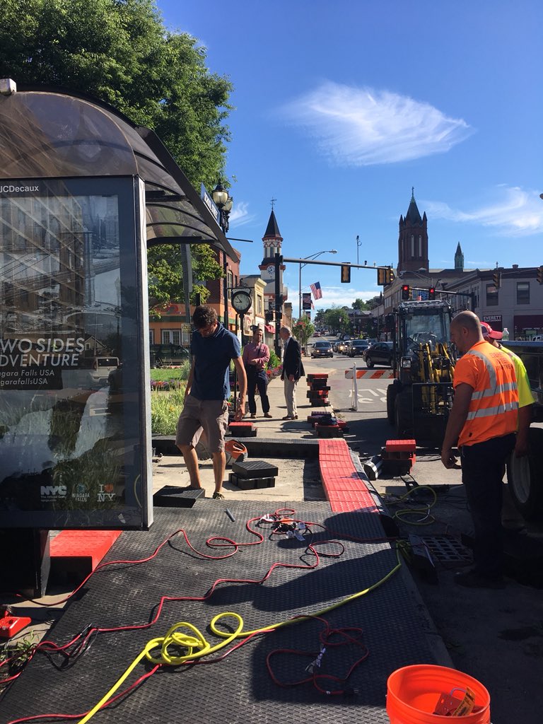
YES! Everett is finally testing bus platforms!

https://twitter.com/skurpie/status/1009424059074072577

Sarah K @skurpie
Jun 20

Excited to see the beginning stages of Everett’s platform level bus boarding area this morning! #bostonbrt #theyearofthebus

DgIxlMXXcAMP-vA.jpg:large
 
So question about the Silver Line Waterfront. A number of people have (rightly) pointed out that the bus tunnel (what was once-upon-a-time going to be called the Piers Transitway, which I do think is a nice service-agnostic name for the piece of infrastructure, à la Tremont Street Subway) really is a double-edged sword for BRT. On the one hand, yes, it's grade-separated and isolated from traffic. On the other hand, because it's not a guideway, vehicle speeds are necessarily extremely low.

Some have suggested that well-placed bus lanes with signal priority might be more effective at getting passengers between South Station, the Seaport and the airport.

My question: what route(s) would be good for this? I was playing around on Google Maps the other day, and between all the flyovers and ramps, it's actually surprisingly difficult to avoid a circuitous route that still gets you into the Ted Williams Tunnel, in part because the entries into the tunnel are actually closer to South Station than a number of the main attractions in the Seaport (especially those that sit outside of South Station's current walkshed).

In an ideal world, a BRT interchange located approximately at the current Silver Line Way stop, straddling the highway and grabbing some land from the police station, where buses can drop quickly from street level into the tunnel, would be helpful. But, particularly absent that, what are the other good options? Seaport Boulevard, Congress Street, Summer Street?
 
Sorry for the ignorance but what makes bus platforms better than a sidewalk with a bus shelter?

Sophisticated BRT systems actually use dual sequential platform level boarding, debarking.

Bus pulls into first platform for debarking.

Then the bus pulls forward to second platform for boarding. Boarding platform is often fare controlled for no delay for payment during boarding.

This dramatically improves boarding efficiency at stops with major passenger changeover.
 
Some have suggested that well-placed bus lanes with signal priority might be more effective at getting passengers between South Station, the Seaport and the airport.

My question: what route(s) would be good for this? I was playing around on Google Maps the other day, and between all the flyovers and ramps, it's actually surprisingly difficult to avoid a circuitous route that still gets you into the Ted Williams Tunnel, in part because the entries into the tunnel are actually closer to South Station than a number of the main attractions in the Seaport (especially those that sit outside of South Station's current walkshed).

Congress Street, Summer Street?

SL3 could potentially be routed I-90 -> Congress St -> new contraflow bus lane on Atlantic Ave -> Summer St -> Pumphouse Rd -> Massport Haul Rd -> The Ramp -> I-90. Hopefully the relevant parts of Summer St could get full time bus lanes and perhaps Congress St from B St to Boston Wharf Rd could get a permanent westbound bus lane and then Congress St from Boston Wharf Rd to Fort Point Channel could have its northernmost lane be a westbound bus lane during weekday rush hour and parking at other times.

If SL1 did airport terminals -> Sumner Tunnel -> Congress St -> Atlantic Ave contraflow -> Summer St -> Pumphouse Rd -> Massport Haul Rd -> The Ramp -> I-90 -> airport terminals, and if the parts of Congress St and Summer St and Atlantic Ave it uses got bus lanes and transit signal priority, I think airport -> South Station might not be any slower than it is now, plus there'd be the bonus Haymarket and State St stops and a closer Convention Center stop.
 
So for those wondering why the 72 is still using diesel buses long after the Huron project finished, I'm told there is a wire problem and they are still trying to locate and repair it.

I observed a diesel 72 in the Harvard busway with exactly one headlight on not so long ago.

IIRC there aren't enough trolleybuses to cover the weekday peak for just 71 and 73 anyway; if battery buses are now being produced in bigger quantities than trolleybuses for the North American market, maybe 72 should just run on batteries?

Martha's Vineyard apparently got a new battery powered bus very recently which probably isn't quite yet in service: https://twitter.com/MassSierraClub/status/1012076787499708416

http://www.vineyardtransit.com/Pages/VTA_BBoard/I05BD8D5A seems to be saying that Martha's Vineyard is buying BYD buses, which means the battery powered buses in service in Massachusetts will soon include both BYD (Martha's Vineyard) and Proterra (Worcester and elsewhere), but AFAIK we still don't have any plug in New Flyer buses operating in Massachusetts.
 
You recall incorrectly. At peak (as of the 2014 Bluebook), the 71 uses 9 vehicles, the 72 uses 2, and the 73 uses 11 plus one RAD, for a total of 25. The trackless fleet numbers 28, of which 2 are currently OOS but will return soon.
 
You recall incorrectly. At peak (as of the 2014 Bluebook), the 71 uses 9 vehicles, the 72 uses 2, and the 73 uses 11 plus one RAD, for a total of 25. The trackless fleet numbers 28, of which 2 are currently OOS but will return soon.

I'm fairly sure I've seen something in some news article indexed by news.google.com at some point in the last several years that there was one diesel bus being used for one or two trips a day on one of 71 or 73. IIRC it was morning only, and the article cited increasing traffic delays and perhaps also increasing ridership as factors leading to that diesel bus. It's possible that it may have been more recent than the most recent Blue Book.

It may be possible that the trackless trolley fleet might be in a better state of repair now than it was then. And when I posted two days ago I also wasn't thinking about how the bus lanes expected in the near future may reduce the number of vehicles needed for 71/73.
 
Um, looks like a bike/bus/parking lane is being laid out on Upper Broadway OUTBOUND (north) in Everett! Thin white markings drawn. Looks the same dimensions as inbound. It could just be a regular bike lane next to parking though.

Given how Everett pilots things, I wouldn't be surprised if cones appeared monday, tbh...
 
The diesel bus was being used for peak-hour short turns because the wire at Benton Square had not yet been restored.
 

Back
Top