Thats $3M+ per bus extra for infrastructure! Im sorry, but that bird wont fly!Electrical infrastructure.
Because the Quincy garage is expected to charge busses overnight, during those hours it will draw about as much electricity as the entire town of Belmont.
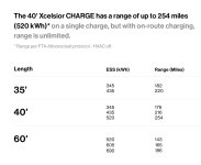
Of course, if electric busses could charge their batteries en-route, from, say, low-voltage wires hung over the street, our bus garages wouldn't have to draw as much power and could be much cheaper to build.
And you don't have to tell me about IMC, I was lead author for TMs report on bus electrification. Most cities would kill to have the legacy infrastructure we are ignoring. Every other wired city is expanding use of IMC buses, while we're scrapping what we have.