MBTA Construction Projects

The new CR platform. Existing island is in the distance touching the other 2 tracks.
(Since I don't know the track numbers) Is the idea "general flexibility" (and you'll never know which platform CR will be on, or is it more like giving Amtrak the center track and having the CR run on the two outside tracks?
 
(Since I don't know the track numbers) Is the idea "general flexibility" (and you'll never know which platform CR will be on, or is it more like giving Amtrak the center track and having the CR run on the two outside tracks?
Somebody else might correct me on this, but I'm pretty sure this is right:

Track sequence, if looking toward Forest Hills (as in the picture's orientation), is 2, 1, 3, left to right. Track 2 is always inbound; track 1 is always outbound; track 3 is generally the direction of the prevailing traffic pattern, so inbound in the morning, outbound in the afternoon. If you wanted to take a train to South Station, you'd need to look at the track listings in the concourse before knowing whether the next train would be track 2 or track 3. But in the afternoon, it would be a good bet that track 2 (ie new platform) would be the correct choice.
 
(Since I don't know the track numbers) Is the idea "general flexibility" (and you'll never know which platform CR will be on, or is it more like giving Amtrak the center track and having the CR run on the two outside tracks?

Needham traditionally runs bi-directional on Tk. 3 into the island platform to keep the amount of crossing over it has to do between Back Bay and Forest Hills to barest possible minimum. Until Amtrak re-did the signal system in 2001 for PTC that was also the only non- cab signaled track on the NEC, as the T used to have a large installed base on the southside of non-cabbed equipment for Needham and (pre- Worcester extension) Framingham turns. So that Needham track assignment was also rote-mandatory for the first 14 years the SW Corridor was open, whereas since then it's merely been customary because of the mandatory Ruggles stop. Providence/Stoughton, Franklin, and Amtrak hug the other two...which is why Providence/Stoughton and Franklin skipped it up to 30% of the time.

Going forward everything's going to have to increasingly go into a blender to manage service increases. This is where the Needham service levels vice grip really starts to get bad, because if overall service increases force it to start playing crossover games reactively its losing battle for carving out enough oxygen before Forest Hills turnout starts accelerating to death spiral. The bi-directional game of keep-away from crossing over already is the hard limiter barring it from any service increases in the Rail Vision while all other inside-128 lines get that new :15 threshold. This new platform is good news for Providence/Stoughton...and Franklin for now (until other spiraling Rail Vision increases force it to Fairmount interlining >75% of the time)...and should allow South Coast Rail to pick up Ruggles if they fix the Phase II single-track breakage that forces excessive skip-stopping between Taunton and Back Bay. But it really does nothing for Needham, and sort of foretells its ultimate fate as a Purple Line route because of the way everybody else's service increases force it into an increasingly claustrophobic zero-growth box.
 
Last edited:
Have we learned enough from GLX to "do" OLX to Needham cost-effectively? They seem very superficially-similar projects (building rapid transit within a CR footprint, with OLX potentially even better because it mostly need not be widened? (no need for 4-track))
 
The track work and ROW adjustments would be even cheaper than the GLX since they wouldn't, in theory anyway, be keeping parallel CR service. But unlike the GLX redesign, an OLX would need larger stations with headhouses, though these could be designed rather cheaply. I want to say, given those trade offs, the cost would be similar. But the issue is going to be ridership levels. Somerville and West Medford are much denser than West Roxbury and have their own economic centers. They also have development potential (ok, Union Sq has the most and West Medford the least, but still). So the return on investment may be lower even if the cost is the same.

OLX is really more about opening up track slots on the Northeast Corridor. Most ppl in West Rox aren't clamoring for the OL... and one could argue they'd come out against it. But because there are clear operational needs a case could be made by the state that such an extension is warranted. Then local support could be built.

I'd still argue that this isn't a high priority. Red Blue Connector or even NS Link/Regional Rail has a higher priority.
 
OLX-Dedham + GLX-Needham were studied multiple times over., so there are previous cost metrics to lean back on there. It should be cheaper than GLX because of the outright mode conversion rather than augmentation + widening, and should not have any buried blowouts. The Green Line half in particular should come pretty cut-rate because as a D Line appendage it would have minimalist non-prepayment stations, leaving only the 4-5 OLX stations as any sort of substantial production. Those savings more than absorb the cost of the Newton-Needham ROW reactivation, new Charles + 128 bridges, and slightly under half-mile of rail-with-trail accommodation. Just don't try to force-fit anything past VFW Pkwy. on OLX on the core build, because the Needham Cutoff and 128 were never benchmarked previously.

For the OLX stations, Rozzie Sq. would be a big one needing substantial busway...but the land is already available if they trade the parking glut for facilities space. Bellevue and Highland are in-the-pit station analogues like the lesser GLX intermediates, and W. Rox is an East Somerville analogue for being perched on a side-street overpass. But with no side-by-side or path accommodations required at any of them. The probable VFW Pkwy. terminus (kind of a gimme add since it's en route to the storage yard) can be a little sprawlier with parking because Home Depot is the only land barter required for that add. The ROW, while very tight-looking in spots especially in the pit around Highland/Bellevue, was indeed double-track into the 1950's and tri-track between Forest Hills and Rozzie Depot. It only looks narrower because of the re-centered track and an additional top coat of ballast dumped on during the 1986 line rebuild to create better side drainage. No structural touches required...probably just some catchbasin installs on the sides for equal-or-better drainage @ DT width.


I mean...if this Admin. ever took up a re-study I *fully* expect it to be a tankapalooza exercise in futility booby-trapped with all sorts of "WTF?"-level blowouts. Because that's just how they roll, and it mutually serves to throw a little more shade at the Purple Line's Rail Vision while they're at it. But much like the last Red-Blue study it won't pass the laugh test, because the cooked books won't track the cost inflation with well-sourced data from previous studies in any rational way. Whatever is variable with Needham conversion costs, it's a substantial cut below GLX's level of complexity. It'd be the sort of thing where if they try to bury a half-billion in "contingency" estimates it gets thrown right back in their face because not even worst-case inflation traces a blowout that large from previous studies...exactly how they ended up backpedaling so quickly from the last Red-Blue tank attempt. So long as they're hellbent on trying to knife the Rail Vision you'll never hear one word uttered by a state-level flak about Needham rapid transit, but if they do indeed go big with the Purple Line service investment Needham Green/Orange transactionally isn't all that outsized if you view it as a de facto cog in that sprawling regional plan.
 
Would OLX to Roslindale Village take some of the load off of the Needham Line? Obviously, that project would have many other advantages, but I'm specifically wondering about the context of an overloaded NEC.

On one hand, you don't want CR service loss for those in West Roxbury and Needham. On the other hand, you would have much better bus -> OL transfers for riders in those neighborhoods.

No...because as per few posts up the track assignments in the SW Corridor tunnel are the chokehold and service increases anywhere else that start forcing crossover games at meets worsen the problem. Getting to the branch in one piece is the sum total of the problem, so it doesn't in the end matter what you do once you're on the branch.

Forced shuttle transfer @ FH is the only way to increase service levels on the branch, but that's a nonstarter for a ton of reasons tops amongst which is how overcrowded FH-Orange already gets from the bus transfer swells. Urban Rail shuttles piling on top of that already bad problem sends that stop to the breaking point of overload, so isn't a viable solution. OLX-Rozzie as +1 to defray the FH crowding problem is over-expensive as a side-by-side construction job (and makes CR meets even harder by stretching single-track even further out) while functionally not doing much more than punting the overall loading issue.
 
For the OLX stations, Rozzie Sq. would be a big one needing substantial busway...but the land is already available if they trade the parking glut for facilities space. Bellevue and Highland are in-the-pit station analogues like the lesser GLX intermediates, and W. Rox is an East Somerville analogue for being perched on a side-street overpass. But with no side-by-side or path accommodations required at any of them. The probable VFW Pkwy. terminus (kind of a gimme add since it's en route to the storage yard) can be a little sprawlier with parking because Home Depot is the only land barter required for that add. The ROW, while very tight-looking in spots especially in the pit around Highland/Bellevue, was indeed double-track into the 1950's and tri-track between Forest Hills and Rozzie Depot. It only looks narrower because of the re-centered track and an additional top coat of ballast dumped on during the 1986 line rebuild to create better side drainage. No structural touches required...probably just some catchbasin installs on the sides for equal-or-better drainage @ DT width.

Would any of these stations change location under OLX, or would all remain the same spot?
 
^ This question has come up in discussions around here over the years. If memory serves, the prevailing wisdom is the Roslindale Village and West Roxbury would stay pretty much where they are, but that Bellevue and Highland might be consolidated.
 
^ This question has come up in discussions around here over the years. If memory serves, the prevailing wisdom is the Roslindale Village and West Roxbury would stay pretty much where they are, but that Bellevue and Highland might be consolidated.

No...doubtful any would change because they're all well within rapid transit spacing. Same number of stops, just possible shifts to re-center on the street corners where the bus transfers are. For example, Bellevue 500 ft. west by the W. Rox Pkwy. rotary, Highland 500+ ft. west to Centre St., W. Roxbury 1000 ft. west behind Star Market so bus routes splitting @ Center/Spring have a busway to turn out to. Inconsequential streamlining like that. Bellevue and Highland are currently on side streets because they used to have old RR depot buildings hosting neighborhood business, and W. Roxbury is where it is because of the old Temple St. junction split between the Dedham and Needham forks. That historical residue, in the form of Bellevue & Highland's small parking lots and W. Rox's somewhat odd station spacing, isn't needed anymore. OLX doesn't have to relocate any of them, but optimized station sitings can/should be studied just to see if there are better multimodal fits on those blocks positioning-wise.

Rozzie used to have a large depot building with freight house, which is why the approach ROW is tri-track width and why the current parking lots are so incongrously large. Very little parking is actually needed, so sizeable station building with busway and bus idling spot are buildable on the slab.


Of course, a VFW Pkwy. stop if it exists at all is just gratuity for the fact that you'll be building a staffed storage yard between Home Depot and the Millennium Park driveway abutting the VFW overpass. Station spacing's fine even if W. Rox gets relocated behind Star Market for the busway, you could have a moderate-sized parking lot if you land-swapped Home Depot for TOD, it would have a large built-in audience from the VW Hospital, and would help the 52 bus (spanning to GL-Newton Centre) become a more significant load-bearing crosstown route while jump-starting some much-needed bus infill into the Dedham transit desert.
 
from NERail (1/1/21)...


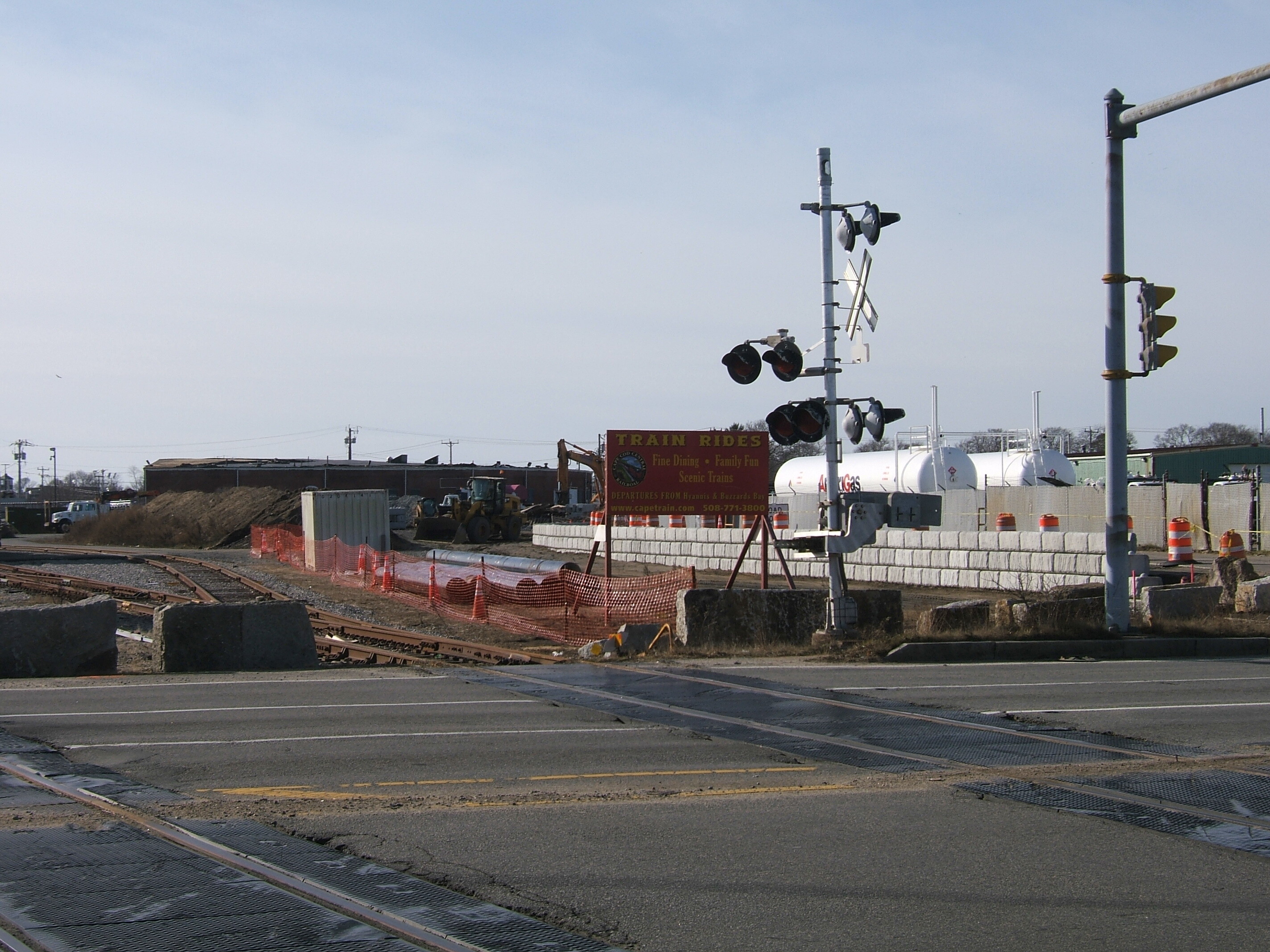
Big construction piles at Hyannis for total top-down rebuild/reconfig of Cape Rail's Hyannis Yard, paid for by MassDOT grant secured a few years ago. Phase I of the yard rebuild closest to the Hyannis Station platform was completed last year. This is Phase II, which significantly embiggens the side of the yard facing Route 28 for additional Cape Cod Central dinner train storage, better Cape Flyer layover facilities, and freight siding for the propane dealer visible next door to start taking freight tanker deliveries from Mass Coastal. Project will finish with a full do-over of the MA 28 grade crossing and traffic signals.

They were late starting this year's work because of that nasty sinkhole in Sandwich back in October that severed Hyannis from the rest of the world for about a month, so are working through the winter. Bunch of T-logo work equipment being borrowed for the track work. That's the old NYNH&H roundhouse (now makeshift parking lot) in the background; they're buffing out the expanded yard limits over there into this cleared field by the multimodal station driveway.
 
None of F-Line's latest pictures are working for me either, but everyone else's pictures are. Also, F-Line's earlier pictures before the last day or two were working for me.
 
F-Line's picture shows up broken in the thread for me, but clicking the broken image tag successfully opens the photo in a separate window. Refreshing this page afterward did not load the image in the thread.
 
Weird. I use Waterfox (1:1 Firefox clone stripped of marketing crapware) and the image loads every time...and I have broser set to auto-flush the cache every time it closes. Maybe it's not rendering right on those using Chromium-based browsers (Chrome, Safari, Edge)?

NERail's (biggest rail "foamer" photo site covering this region) is pretty oft-sourced around here for construction pics around GLX and anywhere commuter rail...so unless their site's having specific embed issues this weekend we should've been seeing lots more image breakage in this thread and couple others by now.
 

Back
Top