You are using an out of date browser. It may not display this or other websites correctly.
You should upgrade or use an alternative browser.
You should upgrade or use an alternative browser.
MBTA "Transformation" (Green Line, Red Line, & Orange Line Transformation Projects)
- Thread starter Arlington
- Start date
themissinglink
Senior Member
- Joined
- Jan 13, 2018
- Messages
- 2,040
- Reaction score
- 5,624

There was a surge in speeding on the Green Line. A system to stop it is years overdue. - The Boston Globe
Common on rail systems across the country, automatic braking technology intervenes and stops the car when a driver fails to yield, essentially eliminating the possibility of human error.
 www.bostonglobe.com
themissinglink
Senior Member
- Joined
- Jan 13, 2018
- Messages
- 2,040
- Reaction score
- 5,624

Long delayed system to keep Green Line trolleys from crashing could be delayed even longer because of patent suit
A company that sells a system aimed at keeping trains from slamming into each other yesterday filed a patent suit against the MBTA and the company it hired to install a system aimed at keeping Green Line trolleys from slamming into each other. Read more.
themissinglink
Senior Member
- Joined
- Jan 13, 2018
- Messages
- 2,040
- Reaction score
- 5,624

MBTA Green Line C Branch construction to begin this fall, bringing ADA upgrades and major disruptions to Beacon Street - Brookline.News
The MBTA is slated to start construction on the Green Line C Branch as early as September. The Green Line accessibility project will elevate and widen platforms to ensure that street-level stations comply with the Americans with Disabilities Act (ADA). Town officials are warning of disruption to...
 brookline.news
While accessibility and safety improvements are “long overdue,” Bill Smith, the town’s construction project manager, wrote in an email to Brookline.News, “The town has voiced (and continues to voice) deep concerns about impacts to Beacon Street.”
The T has said it anticipates multiple stations to be under construction at once to meet the project schedule. Work will be “substantially completed in 2026,” according to a T report, and any temporary disruption to the C Branch service will be replaced by shuttle bus services.
[...]
Brookline town officials and residents have indicated concerns about the C Line project’s environmental and economic impact, as well as decreased accessibility for seniors who live at the senior living apartment complex near the Fairbanks stop and benefit from its current location.
The T’s design plans show that 91 to 100 parking spaces will be eliminated along the Dean Road, Hawes, Fairbanks/Brandon Hall, St. Paul, and Tappan Street stations to accommodate the wider platforms. EDAB members have suggested that getting rid of even a small number of spots would affect small businesses on the corner of Summit Ave and Beacon Street.
cubbe8
Active Member
- Joined
- Mar 18, 2022
- Messages
- 414
- Reaction score
- 725
May 2025 accessibility report
If your business is completely reliant on free parking to survive, then you don't have a business; you have an enterprise collecting subsidies from the public.MBTA Green Line C Branch construction to begin this fall, bringing ADA upgrades and major disruptions to Beacon Street - Brookline.News
The MBTA is slated to start construction on the Green Line C Branch as early as September. The Green Line accessibility project will elevate and widen platforms to ensure that street-level stations comply with the Americans with Disabilities Act (ADA). Town officials are warning of disruption to...
themissinglink
Senior Member
- Joined
- Jan 13, 2018
- Messages
- 2,040
- Reaction score
- 5,624
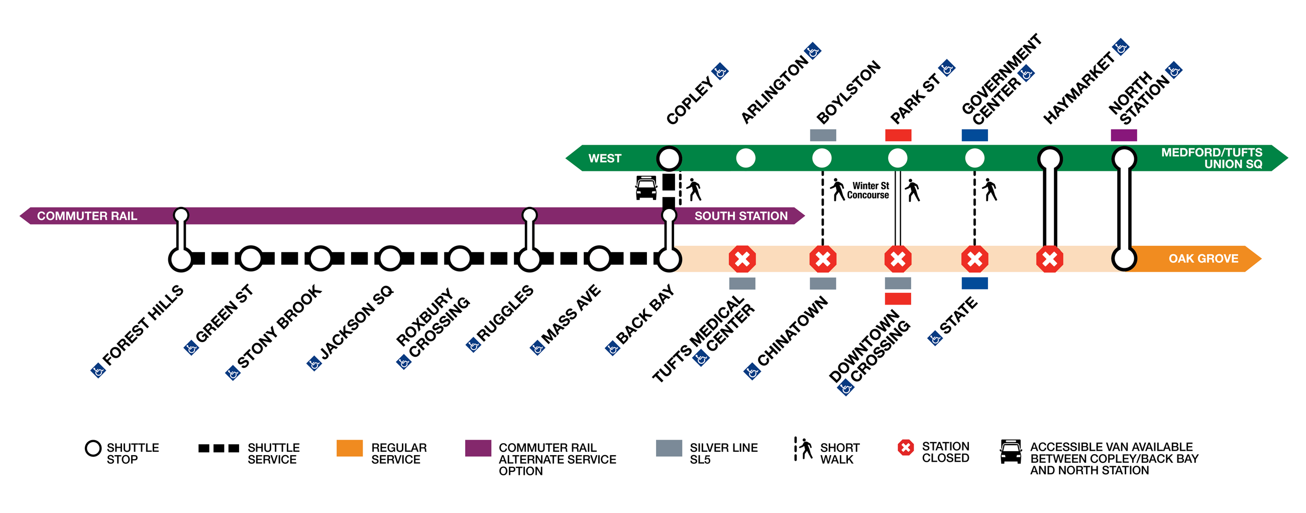
SW Corridor Orange Line Service Suspended June 21-29 - Streetsblog Massachusetts
The MBTA is suspending service on Boston's segment of the Orange Line for the next nine days, starting Saturday June 21, to install new a new signal system.
 mass.streetsblog.org
During the closure, the usual alternative services will be available:
- There will be free shuttle bus service that will make stops at all of the stations between Back Bay and Forest Hills. During the weekend closures between Back Bay and North Station, riders are encouraged to use parallel Green Line. service instead.
- The Commuter Rail trains will be fare-free between Forest Hills, Ruggles, Back Bay, and South Station.
- Route 39, the frequent-service bus route that runs from Forest Hills to Back Bay station via Huntington Avenue, will also be fare-free, with additional service during the closure.
- Plan extra time in commutes and anticipate longer than normal travel times for shuttles.
cubbe8
Active Member
- Joined
- Mar 18, 2022
- Messages
- 414
- Reaction score
- 725
Newton Highlands will start construction in 2027
 www.mbta.com
Newton Highlands Station Accessibility Improvements | Projects | MBTA
Official website of the MBTA -- schedules, maps, and fare information for Greater Boston's public transportation system, including subway, commuter rail, bus routes, and boat lines.
$32,000,000 for some concrete ramps.Newton Highlands will start construction in 2027
Newton Highlands Station Accessibility Improvements | Projects | MBTA
Official website of the MBTA -- schedules, maps, and fare information for Greater Boston's public transportation system, including subway, commuter rail, bus routes, and boat lines.
bigeman312
Senior Member
- Joined
- Jul 19, 2012
- Messages
- 2,408
- Reaction score
- 2,511
North Wilmington was just rebuilt to be fully accessible. It cost $2.7 million. What makes this project 12 times as expensive?$32,000,000 for some concrete ramps.
The EGE
Senior Member
- Joined
- Jun 29, 2013
- Messages
- 1,902
- Reaction score
- 5,245
They're not really comparable projects. Off the top of my head:
- Newton Highlands is a more physically constrained environment - a trench in a village center, with no road access to track level. Overhead lines make crane access difficult. Almost everything will have to be hi-railed in from Eliot or Chestnut Hill, or brought down from street level. All of this has to take place without damaging the historic station building. North Wilmington had easy truck access along the ROW and from Jefferson Road.
- Newton Highlands has trains every few minutes 21 hours a day. A lot of work will require single-tracking or evening/weekend shutdowns. Because the station abuts residential properties, night work may be limited. At North Wilmington, work could take place between trains with minimal disruption.
- Because Newton Highlands is being rebuilt in place, passengers have to be accommodated at all times. Single-tracking requires additional staff; station or line closures require busing. Accessibility has to be maintained during construction (or an accessible shuttle provided), including during the transition to Type 10 LRVs. At North Wilmington, the new platform was away from the old and service could continue normally, and the existing platform was not accessible.
- North Wilmington was a minimalist design - recycled bridge decks, metal ramps, deck-type foundations - that may or may not be long-lasting. With ~60 passengers a day, it will see minimal wear. Newton Highlands will have sturdier platforms, paved ramps, etc - facilities suitable for >1,000 daily boardings.
F-Line to Dudley
Senior Member
- Joined
- Nov 2, 2010
- Messages
- 9,970
- Reaction score
- 12,307
In addition to what @The EGE said, North Wilmington opted for a Lynn Interim-clone 2-car freestanding temp platform because of the uncertainty of whether that stop will exist at all should the Rail Vision get implemented and all thru-Haverhill trains get relocated to the NH Main leaving just the Reading short-turns. It's only got about a dozen years of life in it before the deck starts decaying from settling.North Wilmington was just rebuilt to be fully accessible. It cost $2.7 million. What makes this project 12 times as expensive?
$3.2M is actually a little expensive for that type of job, but I think that a good chunk of that was related to utility work for lighting and comms which didn't exist at the very spartan old station.
bigeman312
Senior Member
- Joined
- Jul 19, 2012
- Messages
- 2,408
- Reaction score
- 2,511
Thank you both for the added perspective!
stick n move
Superstar
- Joined
- Oct 14, 2009
- Messages
- 13,482
- Reaction score
- 24,540
Heres the pics from that linkNewton Highlands will start construction in 2027
Newton Highlands Station Accessibility Improvements | Projects | MBTA
Official website of the MBTA -- schedules, maps, and fare information for Greater Boston's public transportation system, including subway, commuter rail, bus routes, and boat lines.
What's the deal with the Alewife crossovers? I've recently rode the red line from there several times, and when departing from the left-side track (where the train needs to use the crossover to get back onto the right side) there's clearly a ~800 foot 10mph limitation. Based on this complete project on the MBTA website, the speed should've been raised at least to 25mph on the crossovers. Anyone know why this hasn't happened yet? Does the track work need to be re-done or is it just the signals haven't been updated yet? This seems like a huge slow zone that somehow hasn't been tackled yet.
www.mbta.com
Red Line Program | Projects | MBTA
Official website of the MBTA -- schedules, maps, and fare information for Greater Boston's public transportation system, including subway, commuter rail, bus routes, and boat lines.
The EGE
Senior Member
- Joined
- Jun 29, 2013
- Messages
- 1,902
- Reaction score
- 5,245
Some neat slides from today's board presentation for the 35th anniversary of the ADA: https://cdn.mbta.com/sites/default/...tion_Honoring 35th anniversary of the ADA.pdf


There's still a ways to go, and getting to 100% is going to require tackling some of the thorny stations like Boylston and Waverley that have been put off, but it's impressive how far we've come. By 2030, there's only going to be 4 inaccessible subway stations, and a dozen or less inaccessible commuter rail stations. I'm encouraged to see that they're already thinking ahead to further improvements like fixing platform gaps, all-door level boarding with no ramps on the light rail lines, and replacing mini-highs with full-highs.
There's still a ways to go, and getting to 100% is going to require tackling some of the thorny stations like Boylston and Waverley that have been put off, but it's impressive how far we've come. By 2030, there's only going to be 4 inaccessible subway stations, and a dozen or less inaccessible commuter rail stations. I'm encouraged to see that they're already thinking ahead to further improvements like fixing platform gaps, all-door level boarding with no ramps on the light rail lines, and replacing mini-highs with full-highs.
Badusername
Active Member
- Joined
- Dec 2, 2021
- Messages
- 258
- Reaction score
- 741
Will Waverly be any more complex than Natick Center? Seems to be about the same except they don’t need space for a third track.Some neat slides from today's board presentation for the 35th anniversary of the ADA: https://cdn.mbta.com/sites/default/files/2025-07/6. FINAL Board Presentation_Honoring 35th anniversary of the ADA.pdf
View attachment 65263
View attachment 65264
View attachment 65265
There's still a ways to go, and getting to 100% is going to require tackling some of the thorny stations like Boylston and Waverley that have been put off, but it's impressive how far we've come. By 2030, there's only going to be 4 inaccessible subway stations, and a dozen or less inaccessible commuter rail stations. I'm encouraged to see that they're already thinking ahead to further improvements like fixing platform gaps, all-door level boarding with no ramps on the light rail lines, and replacing mini-highs with full-highs.
The EGE
Senior Member
- Joined
- Jun 29, 2013
- Messages
- 1,902
- Reaction score
- 5,245
No easier, for certain. It's a narrower trench, so you probably have to single-track while building the platforms. The 4 miles between Waltham and Hill Crossing would be a long and fragile stretch of single track unless you add new crossovers. The curve doesn't make it easy either.
In the 2000s, the MBTA proposed to combine Belmont Center and Waverley into a single station with no walkability and no bus connections. In the 2010s, they proposed it again (after proposing a ridiculous design for Waverley with horrendous ramps). Both times, the community was furious. So there's definitely a legacy of distrust to overcome, and the recent proposal for 400-foot platforms isn't going to help that.
In the 2000s, the MBTA proposed to combine Belmont Center and Waverley into a single station with no walkability and no bus connections. In the 2010s, they proposed it again (after proposing a ridiculous design for Waverley with horrendous ramps). Both times, the community was furious. So there's definitely a legacy of distrust to overcome, and the recent proposal for 400-foot platforms isn't going to help that.
cubbe8
Active Member
- Joined
- Mar 18, 2022
- Messages
- 414
- Reaction score
- 725
The MBTA has changed the design for the future C branch platforms in order to preserve trees. The platforms will be parallel from each other in their current locations instead of being at the far side of the intersection which would have enhanced the signal priority.
 brooklinema.portal.civicclerk.com
Public Portal • CivicClerk
CivicClerk events and agendas for citizens
The EGE
Senior Member
- Joined
- Jun 29, 2013
- Messages
- 1,902
- Reaction score
- 5,245
Looks like changes to 3 platforms versus previous documentation: Hawes IB, St Paul OB, and Dean IB get moved nearside (all matching how they currently are). Unfortunate, but not the end of the world. It only means a loss of TSP benefits at those three signals in one direction; all other TSP shouldn't be affected. I've been on a BRT project where a few stops had to be retained nearside for various factors, and it didn't cause any issues.
The combined Fairbanks/Brandon Hall station is also modified. Early 2024 plans called for the inbound platform approximately where Brandon Hall is and the outbound platform at Fairbanks, with ramps to the north side of Beacon Street at the existing stair locations (Mason Path and Lancaster Terrace). The late-2024 environmental documentation called for both platforms at the Brandon Hall site, with a single ramp halfway between the existing stairs. The new plans keep the platforms at Brandon, but have ramps and stairs at the existing stair locations. I think that's an improvement on both the previous designs, especially having both stairs and ramps. I do worry that there will be a desire line from the outbound platform to the western stairs/ramp, where passengers would walk along the tracks rather than cross the tracks twice.
The combined Fairbanks/Brandon Hall station is also modified. Early 2024 plans called for the inbound platform approximately where Brandon Hall is and the outbound platform at Fairbanks, with ramps to the north side of Beacon Street at the existing stair locations (Mason Path and Lancaster Terrace). The late-2024 environmental documentation called for both platforms at the Brandon Hall site, with a single ramp halfway between the existing stairs. The new plans keep the platforms at Brandon, but have ramps and stairs at the existing stair locations. I think that's an improvement on both the previous designs, especially having both stairs and ramps. I do worry that there will be a desire line from the outbound platform to the western stairs/ramp, where passengers would walk along the tracks rather than cross the tracks twice.