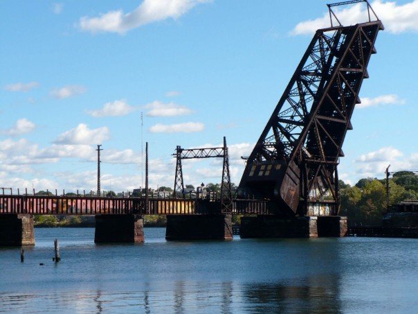
Providence East Side Railroad Tunnel

Arlington

Moderator
Staff member
Joined
Dec 10, 2011
Messages
5,599
Reaction score
2,707
From what I can tell when they realigned the NEC tracks they made this unusable. Never got a chance to explore the tunnel.
 
When Amtrak was still using Union Station on Kennedy Plaza the train tracks were where Memorial Boulevard now runs behind Union Station. There were railroad bridges which crossed North Main Street and Canal Street with tracks then joining the tracks behind Union Station. The new providence Station is further north near the lawn of the State Capitol and the tracks (Amtrak, MBTA, and freight run under the current train station. The railroad bridges over North Main and Canal were demolished. The Citizens Bank Building is in the path of the ROW from the East Side to downtown. If the tunnel were used going forward any train would dead end on the Benefit Street end of the tunnel.
 

Not the East Side Trolley Tunnel (that RIPTA uses for Buses), but the former heavy railroad tunnel originally built to take tracks from Union Station eastward for some very straight-and-fast running toward Boston

Did the construction of One Citizens Plaza preclude its re-use?

It doesn't preclude, but it does make reconnection tougher because all trajectories pass uncomfortably close to it. So the siting was indeed a brainfart...just not a fatal one.

It does block the path of the old elevated line torn down in 1983 that ran curbside-adjacent along Elizabeth St. into old Providence Station, but so much else has changed with the whole area and the whole track layout for the move to the underground bunker station that the Viaduct trajectory wouldn't be the means of reconnection today. Memorial Blvd. was built on top of what used to be the old elevated platform berths for Old Union Station. To reconnect you'd probably incline-down out the tunnel portal instead of incline-up, take a close pass behind 10 Washington Place, and diagonal under the canals onto the footprint of Memorial Dr. underneath the wedge plaza on the south-facing side of One Citizens. You're on-trajectory under Memorial.

The dilemma then becomes the station itself, as the 1980's bunker is well-offset from where trajectories would merge. However, it isn't the most enticing station in the world in current state, and there are fairly inexpensive relocation options. If you made a new primary headhouse underneath Providence Place and spit platforms out the west side of the air rights cover-over underneath the I-95 spaghetti ramps you'd be able to trade what's currently very poor land usage for a new union station that's much closer to where the old one was than the current bunker, with an attractively straighter alignment. Amtrak on the East Side trajectory can be on the lower level, crossing under the canal to slot underneath the current tracks as they pass under Providence Place. The resulting station would look much like North Station with the ramps zooming overhead way in back and the waiting room inside a renovated portion of Mall. Cheap cosmetic cover-over possibilities can make the tracks under the highway slightly better-presented (it's crap-zero land use anyway), and the lower-level tunnel would sprout up at flying junction a few feet west of 95 on a much more tangent trajectory than anything that interfaces the fugly curve through the current bunker.

As long as you can come up with a *semi* change in vision for Providence Place now being a primary headhouse and waiting room, none of this is all that hard to pull off and is probably a large improvement over the current bunker with headhouse underwhelmingly offset from primary foot traffic. 10 Washington and One Citizens are close shaves with building mitigation...but nothing a 2-track tunnel extension couldn't handle. And everything else like Memorial Blvd. and the very artificially reshaped canals is mid-1980's cleanroom from the demo/rebuild of the rail alignment with no environmental blockers to underpinning with tunnel and zero messy utility relocations.

--------------------------------

The main reason for pause, other than cost, is "Why?" The actual Amtrak time savings for using the straighter East Junction alignment for a little more 165 MPH territory isn't large. In part because the slow zone is confined to only Pawtucket with the Attleboro Cutoff at the state line being existing 125 MPH. Alon Levy modeled it and it really didn't project big enough to be worth doing. While Pawtucket has some congestion, it's nothing like what Amtrak encounters in Greater Boston so the traffic separation here does little.

Rather, the value proposition for reconnecting the tunnel probably has much more to do with commuter rail service increases than Amtrak. Providence Line RUR and RIDOT Intrastate's overlapping Woonsocket-Providence + Providence-Westerly patterns with sparser outer ends and denser midsection Pawtucket to Davisville or Wickford are game-changers for mode shares. But if Amtrak were able to vacate to the east side such that it was just passenger trains and P&W freights on the old alignment, you would be able to infill true Urban Rail station density inside the I-295 belt and basically layer a South Attleboro-T.F. Green "Fairmount Line" worth of service stopping every half-mile. Think infills at Roosevelt Ave. at the state line + Central Falls plugging the South Attleboro-Pawtucket gap, Mt. Hope and Smith Hill spanning Pawtucket-(relocated) Providence. Then the much-needed Olneyville infill spanning Providence and Cranston. Boston RUR service skip-stops South Attleboro-Pawtucket-Providence-T.F. Green as usual, while the hyper-locals rapid transitize through the infills.

With a scenario like that where you're densifying the local stops and making it such that Providence Line long-hauls are the new expresses...THEN it makes sense to boot Amtrak through the tunnel to kick on the afterburners. Because they will then need a super-super express set of tracks if the T is taking the existing expresses. In that case an angled trajectory out of the east portal running along the riverbank to Waterman Ave. with new fixed-bridge crossing pointing northwest ramps up the speed way more than the old drawbridge's right-angle wye and they can very quickly ramp up to 125-165 MPH.

^^That's^^ very different from what NEC FUTURE studied. They were only considering Amtrak needs in isolation, not commuter rail needs as a driver. In real terms Amtrak's needs are not so huge that it can get this alt alignment built by its own gravity. But saturate commuter rail traffic instead with quasi rapid-transit layering???...that's a very different story.

Would any of what you outlined improve Bos-Prov commuter rail performance in terms of eliminating the idle time where the CR trains have to sit motionless, shunted aside, while the Amtrak hi-speeds barrel past them? Someday I'll have to time it but it could be up to 2-3 minutes wasted when all is said and done (think about it: time lost braking; time lost idling; time lost having to re-accelerate?) I'm guessing it wouldn't help because it all comes down to MBTA being a "renter" of what is Amtrak's ROW?

I know it sounds trivial to complain about it but it's annoying when there's all this hype generated by the Baker-Raimondo summit re: implementation of an express CR service... and then crickets for month... and no talk about ever trying to address this inefficiency... and looming is the new Pawtucket stop which will only add more time to the total commute.
 
I think you would only look at the East Junction route if you are contemplating 200 MPH service and up and at that point you are probably contemplating a re route west of Providence until you get to the tangent track s at Cranston.
 
Would any of what you outlined improve Bos-Prov commuter rail performance in terms of eliminating the idle time where the CR trains have to sit motionless, shunted aside, while the Amtrak hi-speeds barrel past them? Someday I'll have to time it but it could be up to 2-3 minutes wasted when all is said and done (think about it: time lost braking; time lost idling; time lost having to re-accelerate?) I'm guessing it wouldn't help because it all comes down to MBTA being a "renter" of what is Amtrak's ROW?

I know it sounds trivial to complain about it but it's annoying when there's all this hype generated by the Baker-Raimondo summit re: implementation of an express CR service... and then crickets for month... and no talk about ever trying to address this inefficiency... and looming is the new Pawtucket stop which will only add more time to the total commute.

All T improvements come from load-balancing Greater Boston inside 128 where overall traffic is heaviest, and adding express tracks through 165/125 MPH Amtrak territory where the speed differential is greatest. Those are entirely Massachusetts touches that don't really impact RIDOT intrastate (or at least the thickest potential portion of RIDOT intrastate inside of 295). Basically something like this.

Greater Boston
  • Quad-track from Plains Interlocking (Green St. before Forest Hills) to Neponset River (Westwood, south-end interlocking with Westwood Industrial Track). Change 128 station to twin-island setup, Amtrak in center, T on ends. *Likely* elimination of Hyde Park Station due to diminishing traffic [see next 2 bullets] and difficulty rebuilding on-footprint.
  • Convert Needham Line to rapid transit to eliminate traffic in SW Corridor tunnel.
  • Interline Forge Park trains over the Fairmount Line lumped with Foxboro trains (possible skip-stops inside of Boston to speed up Forge Park), eliminating *most* NEC Franklin trips (select trips can still go via Back Bay/Ruggles when slotting is favorable). If RUR transfer desirable, NEC platforms at Readville can be reopened. Providence + Stoughton/South Coast will be the only T traffic left, save for those spotty Franklin backfills. This is why Hyde Park Station is probably a goner.
  • Tri-track NEC side of Canton Jct. by moving southbound platform back along parking row so Amtrak can pass before 2-track pinch at Canton Viaduct. Lengthen all other CJ platforms so Stoughton inbound trains no longer overspill the junction switches when berthing long trains. TBD whether tracks can be added between 128 and CJ through the rock cuts south of the Neponset. May need Amtrak's funding help to blast contiguous tri-track through here, but if 128 Station is quad-track and CJ Station is tri-track there's ample sorting opportunity.
High-Speed Territory
  • Redo Sharon and Mansfield stations as full-high quad-track w/ 2 center expresses. Ample room at both. Initially do the new outer platform tracks as turnouts from a 2-track mainline, as this will be enough initial relief that quadding the mainline is not immediately required. Quad mainline can be backfilled between stops on Amtrak's dime later as needed.
  • Add 1 crossover at Attleboro Station for high-and-wide freight passage, then raise existing platforms.
  • Redo South Attleboro as quad w/ outer turnout tracks. Note that quad-track will not be future-backfilled here because the Attleboro Cutoff ROW is 2 tracks only.
  • Amtrak eventually backfills center Tracks 3 & 4 from the south end of Canton Viaduct to East Junction, joining together all the turnouts the T built when expanded Sharon and Mansfield earlier. It's now a full quad-track RR Forest Hills-Westwood and Canton-Attleboro, tri-track through Canton Junction and South Attleboro stations, and inconsequential lengths of double on Canton Viaduct-proper and on Attleboro Cutoff on either side of South Attleboro station.

^^That's^^ basically all you will ever need to max out the Providence Line. The most consequential part is removal of Needham and most Franklin trains and the track improvements to 128 to carve out the sorting headroom in the unexpandable SW Corridor tunnel. Everything else is just basic traffic separation by speed differential. The overall quantity of tracks is not all that important, so don't get hung up on the fact that there's small portions like Canton and South Attleboro where it's less than 4 tracks. You don't need all 4 in places where T vs. AMTK speed differential is a lot less extreme and lot less conflict-prone. This isn't the New Haven Line where all 4 tracks are packed to the gills.


Rhode Island
As above, the reasons for the extra tracks in MA is either managing thick congestion in Boston or divergent speed differential. You don't really have either in Greater Providence, so reanimating the East Side Tunnel just for trading up Amtrak speeds isn't really going to float the whole value proposition of reconnecting the tunnel on a canal/Memorial Blvd. alignment and relocating Providence Union Station under Providence Place. Right now speeds cut from 125 to 70 MPH at the Blackstone River bridge at the state line where the Attleboro Cutoff meets the P&W mainline alignment at "Boston Switch". Then two small 60 MPH restrictions bookending the old Pawtucket Station, and a 30 MPH pinch on the sharp 1980's new-alignment curves into both sides of the Providence Station bunker (inconsequential because all trains stop there). South of Providence it's back to 70 MPH along Harris Ave., a short 55 MPH restriction where it bends around the RI 10 expressway and Mashapaug Pond...then back up to 100 MPH through Cranston and 165 MPH again at Cranston freight yard across from Roger Williams Zoo.

The trade from the Pawtucket-South Attleboro alignment with its half-and-half mix of 60-70 MPH and 125 MPH to the East Junction alignment with 60 MPH from the new river crossing to 165 MPH north of the 1A overpass in Rumford helps an Acela schedule a little bit (but in real-world not as much as the ~4 mi. swap of speed zones looks on a 2D map), and NE Regionals not at all. It's too much expense for basically fluffing around the edges. So to hit a value proposition for the tunnel there has to be a congestion angle to it.

Providence has always wanted its streetcar network, with its general S-shaped alignment through downtown and recycle of the College Hill bus tunnel (NOT the RR tunnel skipping all that catchment). That base build would have generally east-west extension opportunities off the mainline "S" by utilizing the disused center lanes on Henderson Bridge as a reservation for eventually extending to the East Providence waterfront and a disused freight line alongside US 6 in Olneyville for eventually spanning to the west end of town. With other spurs to the north and northwest spanning out to the Pawtucket line. Should they make a second go at these streetcar plans the NEC potentially serves up a complementary piece at running north-south Urban Rail inside the I-295 belt at streetcar fare, where multiple transfer touches could quasi-integrate the LRT and Fairmount-style Urban Rail systems as rapid transit. Consider NEC Olneyville or Mt. Hope infills as potential rapid transit connections. Figure a 15 min. frequency zone that spans the state-line RIPTA transfer at South Attleboro (where these Urban Rail EMU's can reanimate the T's disused East Junction layover yard for turnbacks) to T.F. Green (deadheading to the proposed "mid-line" layover at West Davisville) spanning 15 miles and 10+ stops. Then you have the regular Woonsocket-Wickford and Westerly-Pawtucket overlaps chucking in their somewhat longer frequencies on the overlap zone, and the Providence Line keeping to the Pawtucket-Providence-T.F. Green bare essentials.

That's probably enough traffic that you have a much stronger case now for Amtrak separation, as Providence Line RUR in particular is going to be working the express track to the hilt for leapfrogging the hyper-local Urban Rail trains making the thicket of additional intermediate stops catered to that semi-integrated rapid transit system with the downtown trolley. Consider as well that if NEC FUTURE picks up a re-study of the Midland New Haven-Hartford-Providence bypass of the NEC Shoreline in less stupid fashion than the sandbagged last study you may see that stir the pot with downtown Providence. The jumping-off point for that alignment would be a flying junction onto the Washington Secondary just south of the 6/10 interchange...right before the NEC goes into 55 MPH restriction around the zoo. If that came to fruition, then reanimating the East Side Tunnel (pushing all of the ^above^ Urban Rail coattails) and relocating Providence Station under Providence Place to merge alignments reduces the Amtrak overlap of all-Acela and 50% of Regionals overlap to just 2 miles through Olneyville on the highway shoulder. Sky becomes the limit on all that you can backfill virtually all points north and south.

Take Two of NEC FUTURE canvassing Providence for bypasses thus needs to much more strongly hinge itself on rapid-transitization of RIDOT Intrastate CR rather than simply bypassing Amtrak for Amtrak's sake. It's majority share moving people between the 295 belt that'll hit paydirt on a value proposition for the tunnel, with Amtrak just being the minority-share catalyst. The direct opposite way we've been perceiving this project so far. Cater your Crazy RIDOT Pitches accordingly, because that's where the real payoff is.

Very informative (as ever), thanks for sketching out both the granular details and the broad patterns/dynamics...
 
Very informative (as ever), thanks for sketching out both the granular details and the broad patterns/dynamics...

The analogy to go for is Denver FasTracks for the overarching strategy. In Denver some of the builds are light rail (i.e. like the Providence streetcar trunk, and allowances for spoke extensions N/NW, west, and to the East Providence waterfront). Some of the builds are mainline RR served up in Urban Rail packaging (like this "295 belt" 15-min. bidirectional layering). Some of the builds are BRT (i.e. to goose up some major RIPTA node-to-node connections). And some are outright longer-haul commuter rail (i.e. Providence Line RUR and the lighter-frequency Woonsocket & Westerly intrastate endpoints with their Greater Providence overlap). But they connected those loose threads for the sell job around Downtown mode integration, managed to secure the steep initial funding, and scored a home run when it opened via the self-evident sell job that it was all one interconnected system.

The fare and transfer integration then takes this pu-pu platter of individual modes and individual builds then turns it into a tightly-wound urban transit system. Streetcar, Urban Rail, and trunkline BRT can all have flat or near-flat fares and tap transfers where they meet in/around Downtown (which can also include intermediate transfer points like Olneyville, Mt. Hope, and others)...all meandering around a similar 7-15 min. bi-directional frequency target. And to the extent that the longer-haul RIDOT Intrastate and Providence Line services contribute to the layering, "295 zone" fares can be flat and servable on the same rapid transit fare until the zones change like conventional CR north of Pawtucket/South Attleboro and south of T.F. Green. A loose conglomeration of builds thus gets tightly bound by the fare and transfer integration in the central city zone, and end up scaling well beyond the steep (for a small city) costs of any one mode's initial buildout.

I would venture that RI is going to have a hard time coming up with the $$$ to do that streetcar anyway unless they can find an NEC 295 Urban Rail hook for it. The obvious RIPTA integration got it to the point of serious consideration last time, but bus + LRT was not nearly enough to push it over the top. They need to cast a wider net. LRT + bus + Urban Rail can be that wider net that gives the streetcar trunkline critical mass to finally get approved. But it requires applying a lot of the same cast-a-wide-net + integrate-the-shit-out-of-it paradigm that Denver did with FasTracks to find that means. Work those synergies to the hilt and other possibilities...such as revisiting of Amtrak through the East Side alignment and a more serious look at Amtrak over the Midland...have a lot more value as re-study targets because of the way they interact with this bigger-than-sum-of-parts urban transit system. Where things like pacing the Providence Line through all those integrated Urban Rail and Woonsocket/Westerly intrastate service overlaps puts more pressure on the Pawtucket-Cranston express tracks and sends Amtrak looking for more capacity in a way they really don't need to under current conditions.

So, basically, it's a lot of very separate threads...but if you philosophize it under a homegrown "FasTracks"-like strategy a lot of big initiatives get tied together under one policy thrust with a lot more urgency to get things done. And the very act of doing that ends up expanding the field to things that today hedge a little towards surplus-to-requirement like the East Side reactivation or re-centering Providence Union under Providence Place. Whether you look at moving parts like those as means-to-an-end or just a natural outflow of rapid transitizing all the rest of the downtown zone, grouping it under that overarching service umbrella also serves to spread the field on things that are ultimately possible with constrained RI $$$. It's why Denver stuck it all under a big honking brand name to sell the value proposition of a package of separate-but-integrated projects. RI should be looking to emulate that paradigm if it wants to push things along within its means.
 
I've previously mused about potential things that could be done if you could get a train into the ESRT western portal. Besides alternative, straighter connection North to the NEC, I think there's a lot of opportunity for RI to make some connections South to Bristol, Fall River, and Newport.

It looks like the Crook Point Bascule Bridge over the Seekonk is being scheduled for demolition in 2026-2027

2809746.jpg


One additional interesting thing of note is that this is at the eastern portal of the East Side Railroad Tunnel (not to be confused with the Trolley Tunnel), which spans under College Hill (passing below the Brown University Sciences Library) and used to link Union Station to East Providence. The western portal is near N Main St. and Elizabeth St., pointing directly at One Citizens Plaza and potentially the Edge College Hill 2 even sooner. This tunnel has been shuttered for a long time and there appears to be no serious proposals for reuse, only a couple of sketches and musings. The main headaches seem to relate to how to link it in any way to the inconveniently relocated train station. While there are certainly many downsides and expenses to the following idea, I think it could be interesting to consider running a form of light rail from Moshassuck Ct. (or a tunnel under the Avalon to connect internally to the station), elevate to the tunnel, and then continue to a reclaimed East Bay Bike Path all the way to Roger Williams University. Perhaps an addition (directly under?) to the Mt. Hope Bridge could then carry it to the existing rail line to Newport (or a new tunnel - bore or c&c down 114).

It'd be about 30 miles of rail on largely (but not entirely) existing ROWs, with the opportunity for a couple of branches (for instance, east after Mt. Hope to go to Fall River MA on existing rail):
pti6D4bl.png

And could compliment the only existing RI regional rail plan, which is entirely focused on the NEC:
Z9sQgAjl.png

While the tunnel was absolutely designed to bypass College Hill, I think you could have a reasonable number of stops and a decent catchment area there by digging only a single excavated station. Stop 1 would be at Providence Station, stop 2 would be "RISD" located at the western mouth of the tunnel, stop 3 would be "Brown" located approximately under the Sciences Library, and stop 4 would be "Eastside", located at the Eastern tunnel exit accessible from Gano St.

For the "Brown" midway station, you'd need to excavate on either side of the tunnel to build platforms/egress. I think this is accomplishable.
mnYUK9R.png

The tunnel slips by the Sciences Library tower, which actually has a large subterranean footprint extending from Waterman to Sciences Park (basically the area around the green bracket shapes). Besides cut&cover on Waterman/Thayer/Sciences Park for construction of platforms and headhouse(s), it's possible some of the existing excavated library space could be generously donated or managed by Brown in order to facilitate a light rail stop from the middle of their campus to Providence Station and Bristol/Newport.

E: Meanwhile a surface running rail from the Trolley Tunnel to Henderson Bridge is a reasonable path mostly on streets - if you didn't mind single-tracking part of it, and/or could demolish a half-dozen properties. There's the shop on Thayer, a house on Brook, you plow straight through the Lippett historical property, a building on Ives, and then have to go through Medway Place:
nP2vMgH.png

Basically, Providence has a habit of building things right in the way of what would be convenient for any new rail plans.
 
Warren Branch is never ever ever coming back. It's too utterly obliterated past the MA state line, and re-route options on or close to I-195 draw the gimp card on bad insertion angles and wetlands permitting. So forget about Providence-Fall River; that's just not got enough prayers to get through an ROW feasibility study. As for Bristol Branch...yes, a new fixed bridge by Waterman St. angled primarily for northeastern trajectory should come with some consideration of feasible angles for a looping southbound wye should that day ever come.

But Bristol is *very* low-leverage for a small, financially-constrained state. The big selling point for Woonsocket and Westerly is that four-fifths of RI's population will be within 10 minutes of a CR station...the biggest share of the remaining fifth comes from upgrading Fall River-Newport after South Coast Rail lurches to a conclusion...and intra-295 Urban Rail + rapid transit in Providence are max-leverage prospects. But RIDOT is only able to dream that far because the NEC is a ready-serve template with so much fed funding coattails, and the P&W main to Woonsocket is immaculately-maintained and pre-existing 60 MPH passenger speed only needing a cut-rate slate of minor upgrades to be ready-serve for CR. It's attractively low-hanging fruit. So...kinda...is Newport since they have aims in the interim at slow-walking Aquidneck Island upgrades for better seasonal transit in the near-term and, with how long it's going to take SCR Phase II to get frequencies worth any damn to FR, they have the luxury of time to ratchet up the intra-island service before it's time to settle up drawbridge rebuild and reactivating the out-of-service (non-abandoned) Tiverton track.

Bristol is a comparably much smaller catchment and is completely, utterly 100% landbanked. They really don't have the means now or ever to mount a restoration effort on their own dime for the metropolises of Barrington, Warren, and Bristol. As is they have to hope for Amtrak Midland bypass interest in the Washington Secondary for a shot at any additional service (West Warwick, Coventry, etc.) outside of core "four-fifths" arc of NEC + P&W mains and those lines' advantageous shared users...and/or the lowish-rent tack-on to the rump end of South Coast Rail for a few daily limited commute extras and extra in-season "Flyer"-esque service. It really is too big a reach to hope for.


That said, if something radically changes in the next 50 years it is a duly RIDOT-landbanked line that will always be available. And in the shorter term some of the trackage in East Providence that was abandoned 15 years ago for construction of Waterfront Dr. may be coming back much sooner. P&W's real estate arm owns the South Quay port facility as a long-term investment with intent to redevelop it for major shipping and trucking facilities given the nearby access to 195. The East Bay Bike Path intentionally bends around this because of its intended industrial redev. Right now P&W is entertaining redev offers with or without rail access, as it's probably going to fetch more interest for trucking than anything else. However, if any tenants want rail RIDOT is required to re-lay 2 to up to 2.5 miles of East Providence Secondary track free-of-charge per the agreement P&W signed with them to landbank the line for Waterfront Dr. A single-track side reservation off to the side of Waterfront would host the relocated line, and P&W would presumably serve South Quay on the overnight.

While that's not going to put the additional 12 miles to Bristol in any sort of play for all the reasons outlined above, it is overwhelmingly likely that South Quay will be served by reanimated rail long before any confluence of events gets Amtrak looking at the East Side bypass. So there will at least be active track going down that way forcing bridge designers to think about their insertion angles so a southbound hookup can be accommodated. Easier to bake provisions for something that's already there instead of 50-years speculative, so that track connection consideration will at least future-proof Bristol hookup for all time.
 
re-centering Providence Union under Providence Place.

I just thought of this today. With the rehabilitated Woonasquatucket River essentially serving as the "moat" at the triple junction of it, the south wall of Providence Place, and the Amtrak/CR tracks, let's say a proposal to stick Providence Station in the basement of Providence Place actually does get floated... what does the EIS look like in terms of possible impacts/harms to the river?

I can imagine environmentalists/preservationists, and even rank-and-file Rhode Islanders, getting very apprehensive about potential harms to the river during/after such a project, given how... foundational... the river's daylighting is to Providence's post-1995 identity and revitalization saga. Or are the preventive measures the engineers/architects/GC would take to ensure no fouling of the waterway pretty cut-and-dried? Or maybe, given the massive footprint of Providence Place mall, there's away to design, demo, excavate in the basement way on the northern side, underneath the Cheesecake Factory and DSW, in such a way as to render any concerns like this irrelevant?

I don't know...that's all speculative. But the river being heavily re-channeled here during the 80's takes away considerable amount of environmental risk because what's there today is fully remediated and wholly human-artificial. Now...the actual connection from the East Side tunnel isn't going to permanently disturb the river. It's going to burrow underneath it in a shielded dig under that very human-manicured 1980's clay fill and find a slot directly underneath where the current tracks peek briefly into daylight coming over the river out of the station bunker and into the Providence Place cover-over. All actual new station construction is under the PP overhang clear of the river, with the platforms spitting out the west side of the overhang under the 95 ramps. By my measure the East Side tunnel extension would undercut maybe 800 ft. total of the most 1980's-manicured portion of river between the Exchange St. and Francis St. overpasses...and that's it. Obviously with current appearance fully restored after construction (to the extent the shield dig even disrupts the surface around here).

That's really not too bad. You just must hang a value proposition around the whole thing which hauls in the fed $$$ for AMTK, because obviously the East Side bypass never happens at all if traffic isn't flush enough on the current Pawtucket routing to have them seeking express tracks for the express tracks. I think you'll have less of a problem justifying partial PP reno for a new train station headhouse when the time comes than you will first getting all ducks in a row for that "FasTracks"-like package of rapid-transit(ish) builds that saturates the existing NEC alignment enough to force East Side into the conversation in the first place.
 
find a slot directly underneath where the current tracks peek briefly into daylight coming over the river out of the station bunker and into the Providence Place cover-over. All actual new station construction is under the PP overhang clear of the river, with the platforms spitting out the west side of the overhang under the 95 ramps.

As a frequent user of this station, I'm completely on board with these ideas and think they make a lot of sense. My question is - is any of this even being considered by RIDOT, RIPTA, Amtrak, etc? From what I can see, everyone is taking steps that either bake in the existing station location, and/or act completely schizophrenically regarding their attitude towards transit.
 
I'm still not exactly clear what a hook-up between the western end of the portal and the current tracks at Providence Place would look like. That's a long viaduct if above ground, and if it's underground, the tracks would need to shoot up mighty fast after crossing the Moshassuck River, because the portal is actually located well above ground level.

And if it's a viaduct... as far as I can tell, that would obliterate Waterplace Park, which seems like an awfully big price to pay. The desirability of giving Amtrak a reroute option is non-trivial, sure, but even in the worst case scenario of hyper-dense local service, it seems dubious. (Particularly since the NEC between Providence Station and the State Line isn't particularly tight -- looks to me like could be tri-or quad-tracked in quite a few places.)

I see two other uses for the East Side Railroad Tunnel.

The first is integration into a regional light rail network. Dedicated ROWs outside the city can be combined with street-running (though hopefully in dedicated lanes) within the city, which mitigates the biggest challenge any NEC-centric solution will have, which is that all NEC stations still sit some distance from jobs centers (e.g. the Hospital District). Providence has a number of suburbs that could fit well into a modern "streetcar suburb" model, not unlike Newton is to Boston. Western Cranston, for example, along the Washington Secondary, East Providence along Warren Ave or Taunton Ave. The tunnel would offer LRT from across the river a faster path into downtown than any surface-running route would (although, again, with judicious use of dedicated lanes and priority signaling, the savings probably wouldn't be severe). (If rapid transit is ever to come to the Route 6 corridor out to Johnston, I see it pairing will with light rail service under the East Side.)

The only way I see trains continuing west from the tunnel is if they are light rail that can go on street level. I see no appetite for rebuilding any sort of elevated there.

The second potential use would be access to an auxiliary mainline terminal, built above street level just outside the portal above North Main Street. From portal to the edge of the remaining embankment is 260 feet. You can add about another 40 feet if you extend the tracks and platform to overhang the street below. All told, you'd easily be able to fit 2 Silverliner Vs on such a track, and could potentially squeeze in three. To me, that sounds like the perfect size for Providence-centered commuter rail rolling stock. The embankment up there is about 75 feet wide, more than enough space for two tracks and an island platform. I'm gonna call this station "Benefit" for the sake of conversation (since it will sit right below Benefit St and it's a colorful name), but obviously it could be called any number of things.

Use this as your relief valve if the NEC ever becomes too crowded. Reroute Worcester and at least some Woonsocket trains down through Darlington into Benefit, especially during peak hours -- that removes them from conflicts with the NEC entirely. Send any Newport, Fall River, or New Bedford trains coming in via Attleboro down this way -- they'll conflict with NEC between Attleboro and Dodgeville, but most of that is triple anyway. If there's ever any appetite for rapid transit-esque service to downtown Attleboro à la Pawtucket (and I suspect there eventually will be), send at least some of those short-turn trains down to Benefit too. And any sort of rapid transit-esque service to Darlington or Rumford -- both residential areas that could easily become transit-oriented -- can terminate here as well.

You could, in theory, even run some MBTA service between here and Boston, but it would need to be short trains, which would have limited use. However, if Rhode Island ever gets its wish for more express trains to Boston, this would be an outlet for them as well. (And I do think that increased non-Amtrak express service is needful.)

There would need to be a robust last-mile solution, but this location is hardly remote, and could easily be integrated into a number of BRT or streetcar routes. And indeed, it is actually ever so slightly closer to Kennedy Plaza in terms of walking distance than Providence Station is.

One downside would be a cramped terminus. I think you can squeeze two tracks in there, but a third would be tricky. That means that layovers would need to be very disciplined -- pull in, let off your passengers, board your passengers, head back out. The upside is that there is ample space on the other side of the tunnel, especially on the far side of the river to add a few sidings -- certainly no further from Benefit than the current Pawtucket facility is from Providence. A crossover would need to be added just within the tunnel as well, in order to allow trains to access both platforms. (I suppose you could put the crossover outside the opposite end of the tunnel, and just make do with 5,000 foot bidirectional tail tracks.)

The other challenge is that this idea works best with electrification -- you could do it with a two-coach diesel train, if you're willing to extend the platform over the street and possibly keep the locomotive half in the tunnel, but it would be less than ideal. The downside is that means that any of those corridors I just reeled off would also need electrification, which is going to be challenging; the very point of being able to divert to Benefit is that such services would be slightly lower priority, which therefore means they'd be lower on the priority list for electrification. It's not a deal-breaker to go diesel, but it's not a help either.

Although I like the idea of a second mainline terminal in Providence, and creating more of a dedicated Providence commuter rail network, even that is an incredibly pie-in-the-sky idea. If RI + MA chose to go full-hog -- say, reducing automobile use by an absurd amount -- then I could see the tunnel being used for something. But absent that, there just isn't that much need, and what need is there can almost certainly be met through other means.
 
I'm still not exactly clear what a hook-up between the western end of the portal and the current tracks at Providence Place would look like. That's a long viaduct if above ground, and if it's underground, the tracks would need to shoot up mighty fast after crossing the Moshassuck River, because the portal is actually located well above ground level.

And if it's a viaduct... as far as I can tell, that would obliterate Waterplace Park, which seems like an awfully big price to pay. The desirability of giving Amtrak a reroute option is non-trivial, sure, but even in the worst case scenario of hyper-dense local service, it seems dubious. (Particularly since the NEC between Providence Station and the State Line isn't particularly tight -- looks to me like could be tri-or quad-tracked in quite a few places.)

It would be a shallow tunnel...never a viaduct. There isn't a path for it as a viaduct; there is as a tunnel. The riverfront is 1986 nuke zone from the old RR alignment free from complex utilities, so you would stick to minimum depth stageable by shivving a metal roof shield under the river clay for each advancing segment of poured tunnel wall. Here's a crude MS Paint schematic:

PVD.jpg


Slipping between 20 Washington Pl. and One Citizens under open plaza will create one half of an S-curve..and that part of the drawing here is pretty true-to-life accurate. How you thread around Waterplace Park onto final alignment underneath the surface tracks air rights cover will trace the back half of that S-curve. That back half is way approximate here on the drawing as you pretty much have a 1-block's radius bounded by the yellow "X's" to trace your path and there are numerous trajectories that would do it.

Yes, Waterplace Park could see some temporary impacts...especially if the space is needed for construction staging and/or boreholes into the main tunneling area. No, that is not a blocker, as everything would be put back together afterwards and disruption in the immediate vicinity shouldn't last more than a year or so.

The general gist of Providence Place Station is depicted...the Mall is the headhouse, the platforms shoot out the back under the highway ramps North Station-style. Amtrak platforms will be downstairs from the main commuter platforms (still shallow-level), and a portal 750-1000 ft. west of I-95 will dump Amtrak up onto the center express tracks. Note how much closer Providence Place is to the traditional Union Station location vs. the 1986 bunker.

I see two other uses for the East Side Railroad Tunnel.

The first is integration into a regional light rail network. Dedicated ROWs outside the city can be combined with street-running (though hopefully in dedicated lanes) within the city, which mitigates the biggest challenge any NEC-centric solution will have, which is that all NEC stations still sit some distance from jobs centers (e.g. the Hospital District). Providence has a number of suburbs that could fit well into a modern "streetcar suburb" model, not unlike Newton is to Boston. Western Cranston, for example, along the Washington Secondary, East Providence along Warren Ave or Taunton Ave. The tunnel would offer LRT from across the river a faster path into downtown than any surface-running route would (although, again, with judicious use of dedicated lanes and priority signaling, the savings probably wouldn't be severe). (If rapid transit is ever to come to the Route 6 corridor out to Johnston, I see it pairing will with light rail service under the East Side.)

The only way I see trains continuing west from the tunnel is if they are light rail that can go on street level. I see no appetite for rebuilding any sort of elevated there.

This will never, ever happen. Because the whole point of the East Side Tunnel is to skip the entirety of College Hill and get over the river without engaging any Providence streets. It's a terrible candidate for LRT, BRT, or anything that aims to serve a purely intracity audience. It takes a long backtrack from the east portal to get anywhere because of the grade difference, and because it is bored deep under the base of the hill there is zero possibility of putting intermediate stops in it. That's why the actual streetcar proposal uses the old-trolley/current-bus tunnel; it's the only way to tap ridership en route. Gov. Chafee tried to get RIDOT to do a study on something/anything that could re-use the East Side Tunnel. The conclusion was that it was utterly inappropriate for anything except RR, for which the NEC FUTURE study was the only possible user as there are no plausible RIDOT commuter rail proposals that would fit it.

The second potential use would be access to an auxiliary mainline terminal, built above street level just outside the portal above North Main Street. From portal to the edge of the remaining embankment is 260 feet. You can add about another 40 feet if you extend the tracks and platform to overhang the street below. All told, you'd easily be able to fit 2 Silverliner Vs on such a track, and could potentially squeeze in three. To me, that sounds like the perfect size for Providence-centered commuter rail rolling stock. The embankment up there is about 75 feet wide, more than enough space for two tracks and an island platform. I'm gonna call this station "Benefit" for the sake of conversation (since it will sit right below Benefit St and it's a colorful name), but obviously it could be called any number of things.

Use this as your relief valve if the NEC ever becomes too crowded. Reroute Worcester and at least some Woonsocket trains down through Darlington into Benefit, especially during peak hours -- that removes them from conflicts with the NEC entirely. Send any Newport, Fall River, or New Bedford trains coming in via Attleboro down this way -- they'll conflict with NEC between Attleboro and Dodgeville, but most of that is triple anyway. If there's ever any appetite for rapid transit-esque service to downtown Attleboro à la Pawtucket (and I suspect there eventually will be), send at least some of those short-turn trains down to Benefit too. And any sort of rapid transit-esque service to Darlington or Rumford -- both residential areas that could easily become transit-oriented -- can terminate here as well.

You could, in theory, even run some MBTA service between here and Boston, but it would need to be short trains, which would have limited use. However, if Rhode Island ever gets its wish for more express trains to Boston, this would be an outlet for them as well. (And I do think that increased non-Amtrak express service is needful.)

Providence does not need an "auxiliary mainline terminal". RIPTA bus connections all zero in on downtown; there's no coverage gaps begging to be filled. Rather, it's the new Pawtucket infill station and some future Olneyville infill after they figure out post- 6/10 Connector reconstruction ROW allowances--both on the NEC mainline--that would serve up the most secondary relief for bus spreading, and the streetcar circulator would greatly enhance the transfer utility of Providence Station and the next-nearest flanking NEC local stops. Layout of existing transit plus how the streetcar circulator gloms onto the existing layout to supersize it are why you have an opportunity to ultimately rapid-transitize "295 zone" hyper-local Urban Rail trips on the NEC. The complement to the streetcar and major downtown-fanning BRT trunk lines under proposal fits like a glove. There's no "auxiliary mainline terminal" reinvention to pursue here through overzealous force-fitting. Everything already converges at known-known points and is simply seeking to be supersized over time with higher capacity and more frequencies.

And no, there would be no need for T service on the East Side bypass. South Attleboro and Pawtucket are too huge to ever omit as stops for an in-district serving schedule, even if any other NEC infills in the "295 zone" get skipped for Boston trains. They pool too many RIPTA routes. Seekonk is too sparse to grant its own stop on a forked schedule, and there are far too many RIPTA buses stopping at the state line which funnel to Pawtucket or South Attleboro for it to be a value-added at all distinct from what they're giving up. The solution for Seekonk is to expand existing GATRA service along MA 152 into Attleboro, and work out agreements with RIPTA so the border-stopping routes on Central Ave. and RI/MA 15 continue a few blocks east to meet up with the nearest GATRA stops on 152.
 
Thanks for the diagram, that makes a bit more sense. Still seems largely unnecessary, and would of course throw out of whack a large number of improvements that are planned for the current Providence Station, which does sit in a better location for receiving north-originating bus routes than would Providence Place.

And yes -- I agree, there is essentially no need for an auxiliary mainline terminal. And, from my perspective, little need for the Amtrak bypass either. In both cases, the East Side Railroad Tunnel seems to present a solution in search of a problem.
 
PART 2. . . (due to character cutoff on original reply)

Riverside said:
There would need to be a robust last-mile solution, but this location is hardly remote, and could easily be integrated into a number of BRT or streetcar routes. And indeed, it is actually ever so slightly closer to Kennedy Plaza in terms of walking distance than Providence Station is.

But that's the problem. You need to think of all sorts of robust last-mile solutions by virtue of trying so hard to force-fit an aux terminal. You don't have to do any of that following the natural order of things at one terminal and following up on the super-size service options like streetcar circulator + BRT for the east-west and cross-downtown coverage and "295 zone" Urban Rail for the north-south coverage...in fare-integrated fashion. Local transit is already immaculately aligned by nature, such that all of the big-money thrust merely goes to scaling it. Nothing, on the other hand, is compelling builds that split or fracture the natural alignment then create busywork for itself backfilling busted links.

One downside would be a cramped terminus. I think you can squeeze two tracks in there, but a third would be tricky. That means that layovers would need to be very disciplined -- pull in, let off your passengers, board your passengers, head back out. The upside is that there is ample space on the other side of the tunnel, especially on the far side of the river to add a few sidings -- certainly no further from Benefit than the current Pawtucket facility is from Providence. A crossover would need to be added just within the tunnel as well, in order to allow trains to access both platforms. (I suppose you could put the crossover outside the opposite end of the tunnel, and just make do with 5,000 foot bidirectional tail tracks.)

Why are we doing this? One 4-track mainline station already aligned with all other modes of transit present and future-supersized does not need to play increasingly desperate keep-away games to do its basic job. So why, on top of creating a bunch of new last-mile problems with an off-alignment alt. terminal, are we also tasking it with being a 24/7 kludge-a-thon with all manner of movements? That makes no sense. What possible service benefit are we tapping for all this trouble except "because reasons"?

For train storage the very large layover yard is in Pawtucket os crammed alongside I-95 where it splits two cemeteries, across the tracks from the freight yard. Low land usage FTW, and a manageable 2 miles of deadheading. No changes needed there. Future RIDOT Intrastrate's layover for overlapping services above-and-beyond what Pawtucket Layover can serve is going to be in West Davisville on some surplus freight yard space at the Quonset Point turnout. Again, taking advantage of intrinsically low-value land abutting the NEC only 2 miles north of Wickford Jct. If they need another for "295 zone" Urban Rail, the T has kept its mothballed East Junction yard in serviceable condition...yep, same 2 miles of deadheading distance away. Pile on RUR service from Boston or Urban Rail service around Providence and the loads just shuffle differently between these 3 sites. Storage is already perma-solved

The other challenge is that this idea works best with electrification -- you could do it with a two-coach diesel train, if you're willing to extend the platform over the street and possibly keep the locomotive half in the tunnel, but it would be less than ideal. The downside is that means that any of those corridors I just reeled off would also need electrification, which is going to be challenging; the very point of being able to divert to Benefit is that such services would be slightly lower priority, which therefore means they'd be lower on the priority list for electrification. It's not a deal-breaker to go diesel, but it's not a help either.

I don't even know what this means. If it's T service, it's going to have a built-to-regs 9-car 800 ft. full-high platform, and if it's an Amtrak NE Regional stop it's going to have a 12-car 1000 ft. platform. Their own specs guides for platform designs only allow less than that when space is constrained, and they damn sure aren't going to constrain themselves in a place like new digs in Providence where the old digs were unconstrained. There is no limit to how long platforms can be sticking out of the west air rights overhang of Providence Place underneath the I-95 spaghetti ramps. It's zero-value land use for any other purpose, so they can fan out luxuriously. If "aux terminal"...with all its other nasty kludges...has to play platform-length games on top of all the other breakage it's introducing, it's not going to get built for that purpose. There is simply no compelling reason to squeeze basic amenities just...so...this...thing...can...be. The value proposition of it all is fucked if that's what it takes.

Although I like the idea of a second mainline terminal in Providence, and creating more of a dedicated Providence commuter rail network, even that is an incredibly pie-in-the-sky idea. If RI + MA chose to go full-hog -- say, reducing automobile use by an absurd amount -- then I could see the tunnel being used for something. But absent that, there just isn't that much need, and what need is there can almost certainly be met through other means.

Again...there is NO need for a second mainline terminal. None. I don't know where this came into the equation. The tunnel hook-in is a bypass for service layering through Pawtucket that is so dense the T is forced to take up residence on the express tracks for its skip-stop Boston commuter runs, leaving Amtrak without any express tracks on the current alignment where it can maintain its higher speed differential. That is the one and only condition that'll force the value proposition of re-hooking the East Side Tunnel. Quite simply:
  1. RIDOT Westerly-Pawtucket and Woonsocket-Wickford intrastate teams with rapid-transitized "295 zone" Urban Rail on the local tracks through many more intermediate stops than currently exist between South Attleboro and T.F. Green.
  2. The T, running South Attleboro-Pawtucket-Providence-T.F. Green has to move to the fully expanded-out express track on the ROW to stay away from the flood of hyper-local RIDOT's.
  3. Amtrak, because of the T taking primary residence on the express tracks running at commuter speed and making *some* local stops, needs new express tracks for maintaining its large speed differential vs. all other traffic.
  4. Four NEC passenger tracks through Pawtucket are not possible because one of them is the P&W mainline freight clearance track for double-stacks and autoracks...and does not have anywhere close to the clearance to be electrified for passenger sharing. It can maybe take a RIDOT Woonsocket diesel, but otherwise helps no one.
Hit this level of traffic saturation, and East Side bypass for Amtrak does a lot of good. The main flaw with NEC FUTURE is that they studied Amtrak isolation for Amtrak's sake...and that wasn't nearly enough to float it because right now the mainline isn't tapped out of capacity. "295 belt" Urban Rail is pretty much the thing above-and-beyond all current proposals which would tap it out and force a new conversation with Amtrak, so that's pretty much the terms of engagement.

You most certainly do NOT have to agree that this is any sort of eventuality, agree that RIDOT will ultimately take its rapid transit vision there (or even bring the streetcar back up for consideration giving north-south Urban Rail its primary hook), or foresee the stars aligning in the very specific ways they must align to do this. After all, it is only speculative...as there is NO active study going about East Side reactivation after NEC FUTURE cut it from its first-round scoping. But if it goes down it's not going to be an alt-terminal kludge-a-thon in the slightest. Providence will always have one union station; its whole transpo network is predicated on that. And local transit is way, way better-oriented to the existing NEC than the East Side alignment...so it's never going to be reanimated as an LRT/BRT tunnel that skips the whole city or host wacky commuter rail alt routes. Its value proposition is solely tied to the question: does Amtrak have enough passing opportunities for its services' speed differential on the current alignment, or is it going to be forced to look elsewhere? And if forced to look elsewhere, what is the new set of local services that ends up forcing it to look elsewhere? That's it...that's the be-all/end-all. Either something will happen that trips those lines, or nothing will ever happen with it at all.
 
As a frequent user of this station, I'm completely on board with these ideas and think they make a lot of sense. My question is - is any of this even being considered by RIDOT, RIPTA, Amtrak, etc? From what I can see, everyone is taking steps that either bake in the existing station location, and/or act completely schizophrenically regarding their attitude towards transit.

It was only skeletally studied as part of NEC FUTURE's initial scoping. It did not make the cut for the final report.

The reason for that is simply that the huge expense didn't gain enough extra 165 MPH territory over the current alignment to make consequential-enough schedule dent on a D.C.-Boston train. The current alignment is simply "good enough" at projected traffic levels to suffice, and there are bigger fish to fry elsewhere. So for Amtrak's needs to change, there has to be a change in the projected local traffic levels AMTK has to swim in on the current Pawtucket alignment that constrains their passing opportunities.

Right now "projected local traffic" for 2040 involves RUR-level Providence Line traffic making South Attleboro, Pawtucket, and T.F. Green stops, and RIDOT Intrastate traffic running Westerly-Pawtucket and Woonsocket-Wickford over a central overlap that includes additional infills at Cranston and *maybe someday* (depending on whether 6/10 Interchange rebuild serves up enough land) Olneyville that the Providence Line largely skips. This is with all intermediate stations present and future being constructed/reconstructed with 2 outer platform tracks and 2 center express tracks...and the mainline between East Junction, Attleboro and Providence Station being mostly 2-track with some significant running lengths of triple. The P&W freight track from the state line to Providence Station cannot be plausibly used for passenger service because it has to remain permanently un-wired to clear the large train of autoracks that P&W transports from Quonset Point to Gardner, MA 6 days a week (south of PVD the "FRIP" track is near-totally fair game for electrification, so this capacity constraint is specific to Pawtucket). Therefore the maximal track layout is considerably less spacious here than it is north of East Junction or south of Providence. But despite that, Amtrak has determined that it can coexist with 2040 projected local traffic.

All it takes, though, is one new local-traffic proposal not currently accounted for through 2040 to upset that balance. And this is because of the constrained track layout which leaves limited expressing options. The biggest potential one you could drop in there is real 15 min. frequency Urban Rail distinct from the longer-frequency RIDOT Westerly & Woonsocket overlaps. Those Westerly & Woonsocket runs are basically not indended to go more than hourly to/from their sparsely-populated endpoints, such that the central service overlap region Pawtucket-Wickford basically sustains RUR-like :30 bidirectional overlap more often than not. "Rapid transitizing" with an Urban Rail layering would not only crank the frequencies to :15 bi-directional, but also pull a page from the Fairmount Line and target multiple additional infill stops in Greater Providence between South Attleboro-Pawtucket, Pawtucket-Providence, and Providence-(proposed) Cranston for similar mile-approximate station spacing. And this would definitely be something they do in tandem with another stab at the Streetcar trunk and major BRT routes, as similar rapid transit fare structure could be deployed across LRT, NEC Urban Rail, and BRT (i.e. the Denver FasTracks analogy of multiple new/borrowed modes being built-to-suit, but with very tight transfer/fare integration). Despite Urban Rail potentially being an easy-enough retrofit for 2040 by its lonesome to potentially account for in Amtrak's NEC FUTURE modeling, the fact that it's most likely to manifest itself as one plank in a pan- rapid transit strategy mounted with Streetcar + BRT makes it a new-look enough prospect beyond Amtrak's RR-centric forecasting ability.

Therefore, if such a "Providence FasTracks"-like prospect does surface, it's going to immediately put Amtrak in a jam. You have a RR that is not greater than 2-3 tracks, where if you are potentially adding 3-5 more intermediate stops you are going to be tasking the T with being primary user of the express tracks going forward so they can pass those additional Urban Rail infills on a S. Attleboro-Pawtucket-Providence-T.F. Green schedule. That takes passing slots away from Amtrak which is running nonstop where the T is making those S. Attleboro and Pawtucket stops. The RR is then too layout-constrained to play any significant crossover games to bail Amtrak out while RIDOT is carving out space to stop at many more hyper-local intermediates...so Amtrak is forced to consider having to run slower at peak load when they must single-file behind a Providence Line train. The debate about the need for new express tracks takes off from there, and that's when you'll at least see some study movement at giving the East Side a second look.

It may or may not look more favorable after study, but those are the conditions that'll bring it back to the study table. It basically only involves Greater Providence casting a wider multi-modal net to revisiting its rapid transit needs: i.e. the Streetcar and hodgepodge of BRT proposals looking to the NEC and Urban Rail frequencies as a means of goosing their core value propositions. Does the Streetcar have a better chance on second shot if it predicates it own build on fare/transfer integration with a "borrowed/blue" mode like :15 north-south Urban Rail frequencies pinging inside 295? I don't know the answer to that, but that's an EXTREMELY ripe package for debating. East Side bypass becomes an outflow discussion as you get far along in the primary rapid transit debate, as the options for traffic-juggling are what they are and eventually zero in on Amtrak as the party with the most to gain/lose by weighing its options. The debate never starts with consideration of the East Side Tunnel, because the moving parts we're talking about are Streetcar and hyper-frequent hyper-local NEC service. But you do inevitably trip on that Amtrak capacity conundrum in the process of planning this out, so the follow-through ends up opening a new round of debate on the tunnel and at least par odds of a serious paper study about the Amtrak bypass. We just have to make sure when we conceptualize this that we aren't talking tunnel-first...because nothing makes practical sense if that's how the discussion is forced to evolve.
 
Last edited:
Thanks for the diagram, that makes a bit more sense. Still seems largely unnecessary, and would of course throw out of whack a large number of improvements that are planned for the current Providence Station, which does sit in a better location for receiving north-originating bus routes than would Providence Place.
Seconded on furnishing the diagram--I just couldn't visualize it without the visual. All other considerations aside, the current Providence station is bizarrely adrift from the downtown core, in comparison to the prior location. The two giant lawns effectively maroon it from everything else.

(It is also beyond insane than the city doesn't put down a crosswalk from the PP doors at PF Chang's to traverse to the lawn, given that's the obvious direct path from PP to the station. But I digress.)

Shifting it to Providence Place--especially if it straddled the I-95 corridor, thereby helping to rehabilitate the amputation caused by the interstate--would far better knit it into the urban fabric. The enhanced proximity to the RI Convention Center, Dunks arena, Trinity Rep, and dead top center that is Kennedy Plaza would all seem to help. What would make it perfect would be a 1,800-ft., due north-south pedestrian/bike/scooter/what-have-you flyover that spanned the Broadway/Atwells Ave. nexus at I-95 all the way up to those hypothetical new surface platforms that F-Line spec'd.
 

Back
Top