Reasonable Transit Pitches

I'm hoping that service to Foxboro returns once Franklin Line double track phase 3 is completed, as the 2019 Foxboro pilot messed with the Franklin Line OTP way too much.

God, I remember that. I was late to work for three weeks straight before they finally got things under control.

I know it's slightly on the side of crazy (because it involves pouring concrete), but I'd love to see service return, and even extended down to Mansfield. Construct an additional platform (perhaps alongside the planned-but-never-going-to-actually-happen quad-tracking of the NEC) that could even just stub-end at the station and serve downtown Mansfield better. Maybe even combine it with a parking garage and actual use of all that parking lot area, extend the common, etc. I'd say deck over 106 to let the station actually connect to downtown, but we all know how those sorts of projects end up going.

I'd also suggest adding new stations along the route, such as downtown Foxborough, a new stop in the powerline RoW south of Walpole station to serve the residential area there, or a new park and ride where it crosses 95 (no new exit, just in that vacant lot next to what Google Maps calls Foxboro Highway Department) with a new road from Central/Commercial St. There's a few opportunities for nearby TOD, and there isn't a great Park and Ride that close by. However, this is Foxborough, and my understanding is that the town is... reticent to allow anything of the sort, so that's probably a no-go.

We're drifting even further into Crazy here, but it seems like it should be possible to tri-track the Fairmount RoW in at least a few places for a central passing siding for express trains to bypass locals. Seems like that would allow even greater service on the outer ends of a combined Franklin/Foxborough/Fairmount line. The "F-Line", as it were.

Town of Foxborough is a NIMBY hellhole that loudly opposed the Gillette regular-service trial. They just didn't have a real mechanism to stop it because the station was already there and only clipped a small sliver of their town they'd already functionally turned over to Kraft-land. There's no local juice at all for adding a downtown stop, much less even running a bus to the existing stop. The quantity of grade crossings around Downtown F'boro--7 in 2-1/3 miles--is also a bit of a performance demerit for trying that one out, as it would not be all that fast through the densest part of Downtown and slow speeds through the crossings abutting the would-be Downtown stop are likely to rankle locally.

Old South Walpole NYNH&H station is still standing on the spur midway between Walpole and Gillette, but there's not much density south of 1A and 1A is well within the walkshed of Walpole Station so there isn't much impetus for infilling. What'll be critical is that they find a solution for rebuilding/ADA'ing Walpole Station with equal access to the Franklin and Foxboro alignments, as the 2019 trial skipped Walpole Station entirely. No regular service can plausibly skip Walpole as it's one of the highest-ridership CR stations on the entire southside and absolutely deserves to have its native frequencies doubled-up. Norwood Central parking ended up getting unduly slammed by ridership diversions from Walpole during the trial as people hungrily sought out the expansion frequencies, so that's another one of the unintended consequences from the trial that needs to be pounded out before they can mount this for-real.


Tri-tracking of the Fairmount shouldn't be necessary at all to facilitate expressing service (if, as planned, Regional Rail'ified Franklin service were moved over to there and skip-stopped while Foxboro-turning locals made all stops). You'd only need to add 1-2 additional crossovers to the existing double-track and finish moving the Readville platform onto double-track to make that work. If the Worcester Line's gianter layer cake of service inclusive of hyper-local Riverside short-turns is easily enough executed by having crossovers spaced 1 every 2 stations throughout Newton, the same general layout should work in Dorchester and Hyde Park with slack to spare. No need to reengineer any ROW where the ROW (at least everywhere north of Cummins Hwy.) has no functional room for additional track.


One big future-leaning upshot of implementing 30-minute local service to Foxboro is that it can help speed up the Franklin end for further extension. The studied Milford extension would have to trawl the almost fractally curvy Milford Branch, which already imposes a burdensome time penalty on the Franklin/Dean-to-Forge Park stop pair that would only get way worse if you added more. Woonsocket-via-Blackstone is straighter and would run at higher native speeds, but stretches far enough outside of 495 that end-to-end times would still be longish and near the outer tolerances of passenger comfort. But if you were able to express through most/all of Fairmount and drop the lesser mainline intermediates like Endicott, Islington, Norwood Depot, and Windsor Gardens out to Walpole you'd gain the time savings on one or both extensions to fit them into 'regulation' 1:00-1:10 end-to-end sojurns. King-size catchments Dedham Corporate, Norwood Central, and Walpole would get 15-minute service from the double-up while the other intermediates would stay at :30, and the total ridership increases from the endpoints by it not being such an over-long slog. So getting this Foxboro turn implemented and well-established is probably part-and-parcel a strategy for forging usefully further from Franklin.
 

With the Dieselstution of the 71 and 73 why not send these buses to Sullivan square along the route the 86 uses. The goal would be to get 5 to 15 minute bus frequencies all day along a line that connects three of the rapid transit lines red at Harvard, orange at Sullivan and green at east somerville). Plus it would go pretty well with a silver line extension to Chelsea.

Here are the resources I used to come up with this
MBTA frequent bus map

MBTA info on 73 bus

MBTA info on the 71 bus

MBTA info on the 86 bus
No BEB's on a route that superextended. It'll be decades before there's batteries available to run a 71+86 or 73+86 duty cycle. It's bad enough what the T is already doing to these routes...consigning them to diesels thru midcentury only makes it worse.
 
I don't think @Ayo is proposing BEBs specifically? Just through-running the 73 + 71 to Sullivan following the route of the 86, in order to increase the number of buses between Harvard and Sullivan.

Which I think is a nice idea, but another problem is going to be number of buses. You're proposing increasing the distance each 73 and 71 bus needs to take, by about 60-70%, which will then reduce the frequency on both the 71 and 73. Plus the lengthier route will introduce more opportunities for delays.

Probably a better solution is to increase the number of buses on the 86 to improve reliability and frequency. Another option (not mutually exclusive) is to short-turn some buses at Harvard/create a new bus route that only goes Sullivan-Harvard. You're right -- with GLX opening, that corridor will become all the more important.

The challenge with that proposal, though, is where to bring in those extra buses from -- which basically amounts to, "where should we decrease frequencies?". And... that's a pretty hard question to answer. Probably the best opportunity to work some creativity is to look at routes who are impacted by GLX opening -- the 87, 80, 88, 90, perhaps the 96.

Overall, good call out -- that corridor definitely should have more reliable service (and I'm glad my map was helpful to you!).
 
  • Like
Reactions: Ayo
Out of curiosity, I looked at the MVRTA bus routing from Haverhill to Lowell.

EDE40DA9-55E4-4F92-BBC3-6F0D382DD5F4.jpeg


Yikes.

This is why the sterotype that only poor/desperate people take the bus exists.

2 hours with a long diversion to the Loop in Methuen and a transfer at Lawrence. For comparison, this is about a 30 minute drive.

Given the amount of students attending Umass Lowell from the Merrimack Valley and a combined population of a quarter million, how reasonable would an express service from Haverhill to Lowell via 495 be? Operation would be similar to the MVRTA commuter service to Boston (https://www.mvrta.com/routes/route-99/) using coach style busses.

My proposed routing (*denotes possible additional stops):

*Newburyport MVRTA Parking Garage
Haverhill Washington Sq Transit Center
Lawrence McGovern Transit Center
*Andover Shawsheen Sq
Lowell RFK Transit Center
*UML East Campus

Only major transfer point missed is the Buckley Transit center in Lawrence, but since the intent is to be relatively time competitive with driving, l selected McGovern since the later would only be a 5 instead of a 10-25 minute diversion, and McGovern is still located relatively central to downtown. Google thinks this routing would be 32 minutes from Washington SQ to RFK Vs 27 minutes driving.

An extension to the UML East campus bus stop would also provide a more direct connection to the (overall relatively OK) UML bus system rather than the infrequent shuttle from RFK. Maybe could even swing a subsidy from UML since their Haverhill campus is located right next to Washington Sq.

The route could also be extended East to the MVRTA parking garage on Merrimack St and/or commuter rail station in Newburyport to provide an express routing through the entire MVRTA service area. The Eastern leg would loose time competitiveness with driving due to the 10-15 minute diversion needed to hit Washington Sq, but the hour trip would still eviscerate the current 3.5 hour 3 transfer current bus service. No idea how feasible this would be since between Haverhill and Newburyport is nothing but rich, low density exurbs.

image.jpg
 
Last edited:
Absolutely not operationally difficult, but as the MBTA moves towards higher frequency services in traditional modes, would it make sense for the MBTA to rebrand some of those services?

For instance, the 15 key bus routes and the proposed expansion of high frequency service. Would it make sense for them to be given an intermediate branding or something else to differentiate them from other bus routes and Silver Line BRT? The key bus routes already appear on the rapid transit map, so something closer to NYC SBS or ripta R-Line makes sense to me. If the comingled fleet makes paint unrealistic, at least put a prefix identifier in the route number or something, like the old CT routes.

Further, should CR electrification and regional/urban rail happen at 15 minute headways, that'd also be a service distinct from both traditional near hourly CR and rapid transit. Especially in the launch phases where only certain line segments will get the upgraded service level. For instance, the 15min Fairmount and EJ corridor services almost definitely should be marked on the transit map differently than hourly Fitchburgs. Keep calling the CR the CR, rebrand high frequency urban rail services as the Purple Line?
 
Last edited:
Further, should CR electrification and regional/urban rail happen at 15 minute headways, that'd also be a service distinct from both traditional near hourly CR and rapid transit. Especially in the launch phases where only certain line segments will get the upgraded service level. For instance, the 15min Fairmount and EJ corridor services almost definitely should be marked on the transit map differently than hourly Fitchburgs. Keep calling the CR the CR, rebrand high frequency urban rail services as the Purple Line?

The color Indigo is reserved for just such a thing. . .
MBTA.jpg
 
Absolutely not operationally difficult, but as the MBTA moves towards higher frequency services in traditional modes, would it make sense for the MBTA to rebrand some of those services?

For instance, the 15 key bus routes and the proposed expansion of high frequency service. Would it make sense for them to be given an intermediate branding or something else to differentiate them from other bus routes and Silver Line BRT? The key bus routes already appear on the rapid transit map, so something closer to NYC SBS or ripta R-Line makes sense to me. If the comingled fleet makes paint unrealistic, at least put a prefix identifier in the route number or something, like the old CT routes.

Further, should CR electrification and regional/urban rail happen at 15 minute headways, that'd also be a service distinct from both traditional near hourly CR and rapid transit. Especially in the launch phases where only certain line segments will get the upgraded service level. For instance, the 15min Fairmount and EJ corridor services almost definitely should be marked on the transit map differently than hourly Fitchburgs. Keep calling the CR the CR, rebrand high frequency urban rail services as the Purple Line?

I always thought this would be a great idea! It could be a great way to distinguish rapid services from those that are less frequent or lower ridership.

My proposal would be to name them the "C" and the "B" - with the same graphic treatment as the "T."

I feel like this would distinguish the modes of transit, but imply they're more rapid/'better.' (plus T, C, B has a decent 'ring' to it)
 
Absolutely not operationally difficult, but as the MBTA moves towards higher frequency services in traditional modes, would it make sense for the MBTA to rebrand some of those services?

For instance, the 15 key bus routes and the proposed expansion of high frequency service. Would it make sense for them to be given an intermediate branding or something else to differentiate them from other bus routes and Silver Line BRT? The key bus routes already appear on the rapid transit map, so something closer to NYC SBS or ripta R-Line makes sense to me. If the comingled fleet makes paint unrealistic, at least put a prefix identifier in the route number or something, like the old CT routes.

One simple thing I would really like to see is better wayfinding signage for connecting to/from the Key Bus Routes. At Harvard, for example, they could do a lot better with signage indicating how to get to the 1/66/71/73/77. Last I checked, the 71/73 still have the wrong signage since being moved to the upper busway. I don't think there's any signage at Watertown Square indicating how to connect from the 71 to 57 either.
 
Last edited:
I always thought this would be a great idea! It could be a great way to distinguish rapid services from those that are less frequent or lower ridership.

My proposal would be to name them the "C" and the "B" - with the same graphic treatment as the "T."

I feel like this would distinguish the modes of transit, but imply they're more rapid/'better.' (plus T, C, B has a decent 'ring' to it)

This idea tickled me way more than I want to admit! And it acknowledges this idea that (in my experience) much of the riding public has, where "T = subway", not "T = MBTA" -- i.e. "I'm gonna take the bus to Malden and get on the T."

The downsides are that we already have services named "C" and "B", and that all three rhyme -- can make it hard to differentiate them over a PA system.

So how about the T, the R, and the S?

T for tunnels -- the subway lines
R for regional rail -- the commuter rail lines and the potential Indigo Lines
S for streets (or surface) -- high-frequency bus routes

You could combine them with numbers as well -- "R1 to Readville", "S77 to Harvard".

One simple thing I would really like to see is better wayfinding signage for connecting to/from the Key Bus Routes. At Harvard, for example, they could do a lot better with signage indicating how to get to the 1/66/71/73/77. Last I checked, the 71/73 still have the wrong signage since being moved to the upper busway. I don't think there's any signage at Watertown Square indicating how to connect from the 71 to 57 either.

Big +1 from me on this.

Cambridge Seven actually originally proposed adding color-coding to bus routes based on which hub they operated out of. For example, Harvard routes would have some sort of red coloring (I think they suggested on the rollsign).

This idea could be refurbished into generally creating stronger links between the bus routes and the subway lines they feed into -- essentially creating, for example, a "family of Green Line services". Using a different letter-number convention than I described above, you could have, for example, the GL57 to Watertown, the RL77 to Arlington, the OL34 to Dedham, the B116 to Revere and so on. I described something like this here last summer. Recoloring the Key Bus Routes on the current map looks like this:

View attachment 11-2021-subway-map-GLB-stops-consolidated - recolored.png

Of course, as you say, the T would still need to actually, you know, put up the signs pointing passengers from one "sibling" of the Green Line to another ("parent" to "child"?).

I do wonder if there is some institutional intertia at play here, with a fear of printing "hard" signage with bus routes on them because the bus routes themselves were changed or renumbered pretty often. To be honest, I think that happens less nowadays than it used to -- and certainly the big ones, i.e. the Key Bus Routes, have remained quite stable. But old habits die hard.

Perhaps with the new coming redesign, we'll see a shift in that attitude.

And of course, there are other types of signage, especially now with electronic digital signage. Not everything needs to be posted on enamel.
 
I'd rather thought the entire indigo concept was dead, but I suppose there's no reason they can't reuse that color!
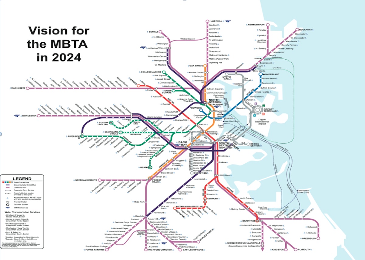
The concept was subsumed by the Rail Vision and the push for :30 frequencies to all endpoints. Functionally, the Zone 1A stops on Newburyport+Rockport, Lowell+Haverhill, Providence+Stoughton, and Fairmount/Franklin+Foxboro will all get :15 bi-directional service by virtue of each carrying two 30-minute patterns in alternation. And then you'd just need to institute Route 128 short-turn supplementals on the Fitchburg Line, Reading Line, Worcester Line layer cake (+ Riverside spur), and Fairmount Line layer cake (compensating up to whatever quantity of Forge Park turns skip-stop on the Fairmount or bypass it altogether on the old NEC routing) to square the remainders up to :15. Otherwise the ingredients are all still there to "Indigo" inside-128 systemwide. Needham wouldn't rate because of capacity constraints keeping headways longer than :15, and the Old Colony main wouldn't rate unless there were enough partial double-tracking to even up JFK+QC+Braintree to :15 service (the splitting by-branch keeps all 3 stops outside that service threshold). Additionally, we can assume that the very capacity-dodgy Grand Junction and Track 61 dinkies just ain't happening. But otherwise the rest of the system would be represented and net a spider map similar to but more inclusive than the one Deval Patrick's Admin. proposed for the Olympics a decade ago.

The rest of the work is just redistributing the Zone 1A designations to be inclusive of all Route 128 touches...meaning at minimum Wyoming-thru-Reading, Wedgemere-thru-Anderson (if not :15-serviced Wilmington), Belmont Ctr.-thru-Weston superstation, Riverworks-thru-Salem (if not :15-serviced Beverly), Newtonville-thru-Riverside, Readville-thru-Dedham Corporate, and Readville-thru-Westwood (if not :15-serviced Canton Jct.) all at minimum get redrawn inside Zone 1A. Colors radiate as Indigo on the spider map from the terminals out to those points, change to regular Purple once you're either in Zone 1+ or only getting >:15 headways. Easy to parse regardless of where you're going, as anything whatsoever interzone is going to be a Purple trip.
 
How about a supercomputer "Train to the Game" to Boston/New York when the Yankees and Red Sox are playing? Lots of fans make the trip up/down already.

Here's the fun part: the trains will arrive at Penn/South Station, but depart from Landsdowne/Yankees E. 153rd street, on the assumption that fans might want to hang out in the city before the game, but want to go right home after it. The train would be held at the station until the end of the game.

Here's a potential service pattern:

RED SOX FAN YANKEE STADIUM SUPERCOMMUTER
Inbound:
-South Station
-Back Bay
-Route 128
-Providence
-New London (?)
-New Haven
-Penn Station/Grand Central

Outbound:
-Yankees/E.153rd
-New Haven (Via Mott Haven Junction)
-New London (?)
-Providence
-Route 128
-Back Bay
-South Station

YANKEES FAN SUPERCOMMUTER

Inbound:
-Penn Station
-Stamford (?)
-New Haven
-New London
-Providence
-Route 128
-Back Bay
-South Station

Outbound:
-Landsdowne
-Back Bay
-South Station
-Back Bay (via reverse move)
-Route 128
-Providence
-New Haven
-New London
-Stamford
-Penn Station/Grand Central
Consist: A rake of Amfleet coaches with a p-42 on one end and an ACS-64 on the other.
 
I apologize if this has previously been discussed here, but a couple of searches didn't bring anything up. In light of the doomed Northern Tier Passenger Rail study that's in progress, I got to thinking about how the state could do transit statewide without it becoming a boondoggle. While for example it is possible to get from Boston to say Greenfield on public transit, that requires 3 transfers between agencies, routes, and fare systems (MBTA, MART, FRTA). Overall, it'd be a tortuous, slow trip.
1658421759475.png

So why not a statewide "super RTA" to operate OTR coaches and leverage the existing uncongested highways on routes where there isn't already a private carrier or rail to connect the secondary cities of MA? Sort of in the vein of NJT commuter coaches - By centralizing to handle interdistrict / intercity connections you would get the most consistent messaging and service delivery, especially if you give them bus-on-shoulder authority.

Many of the individual RTAs already run intercity shuttles, but awareness and ridership isn't precisely high. MVRTA runs both a commuter coach service to Boston and a transit style connection to Lowell, MART runs both a Worcester and a Boston Shuttle, etc. Plus, looking at the 2022 Official Multimodal transit map, there are fairly significant gaps in the overall private network. What I'd start with are the following:

1) The Northern Tier Route makes sense, running from N. Adams to Boston via Greenfield, Gardner, Fitchburg.
2) Lowell to Worcester, with future extensions, if given interstate authority, to Providence and Manchester. This should help prove the use case for future rail.
3) Outer Cape - I think that Peter Pan route is already subsidized. (As was the former P&B service there.)
4) The various intercity "Shuttle" and connecting routes operated by the RTAs. (Worcester-Fitchburg, Greenfield-Northampton etc.)

If the state doesn't want to directly operate the service, there's also nothing stopping them from using a contracted operator model similar to the Logan Express, or even a subsidized private route. Prior to 2010, the state had an "Interdistrict Operating Subsidy Program," which subsidized a number of routes, and the state still uses federal intercity bus funding to subsidize service on the outer cape.
 
Last edited:
Speaking with some people in the Boston Transportation Dept, there is a "southwest Boston study" coming which is going to (among other things of course) look at orange line extensions. Alternatives specifically mentioned include the two commonly seen "eat the Needham line" proposals, one to Needham and one stopping at WRox, as well as an alternative that will look at a subway south under Washington Street to a point TBD
 
So does anyone know if there ever was engineering confirmation of the feasibility of turning the track westerly towards the ER ROW? Can it be done inside of the Wonderland property or do houses go?
 
So does anyone know if there ever was engineering confirmation of the feasibility of turning the track westerly towards the ER ROW? Can it be done inside of the Wonderland property or do houses go?
It would most likely work if you abandoned the current Wonderland station and built a new one on an elevated spanning the rotary (i.e. banking left of the garage instead of right). Would require taking 1-2 cruddy transient private businesses, although ground-floor retail at the new station would more than compensate for that. Would also be an opportunity to nuke the bad rotary design for traffic calming in a package.

I doubt that's going to price out real well on costs, though, because of the duplication of fairly new station infrastructure. The station would also have poorer accessibility to the nearest residential at the modified location vs. the current one.
 
Last edited:

Back
Top