Reasonable Transit Pitches

A Blue Line tunnel to Kenmore via Charles/MGH would serve anybody coming from Kenmore and points west and at least half of the Back Bay with destinations on the northern half of the Red Line and anywhere on the current Blue Line, including Government Center, and vice versa. It would also serve as a Blue/Red Connector at Charles/MGH. I'm sure this is a sizable number of people.

Forgive me if I'm missing something, but your proposal is to have the green line branch, going westbound, after Park Street, without touching the Park Street-North Station stretch of the tunnel. This would certainly not decrease ridership on the green line (which is not a bad thing) but would still send those same riders, and maybe more, through the same Park Street-Government Center tunnel (which is a bad thing).

You're missing something important. My proposal adds additional platforms to Park Street under Beacon Street to service an auxiliary tunnel to Government Center on the opposite side of the burial ground. It doesn't touch anything Government Center-north, but nicely bypasses Park Street - Government Center (and, should Heavy Rail Green ever reach critical-mass levels of support, also nicely bypasses the long string of problem stations that is the Boylston Street Subway.)

How would a Blue Line Kenmore-Government Center via Charles/MGH and Riverbank not relieve the Green Line? Currently the only way Red and Blue passengers can head west is by transferring at Park and Government Center; extend the Blue Line to Kenmore (and eventually choose a route to head further west), and you'll eliminate the Blue demand that the Green is carrying as they'll be able to go single-seat. That would also put a big dent in Red-Green transfers considering the alternate transfer point at Charles/MGH.

Edit: Looks like I was too slow at typing. :D

Right, I'm not saying do this instead of Red-Blue Connector.

Just the opposite, I'm saying do this because it stops Riverbank from becoming conflated with Red-Blue Connector - and, frankly, the Blue Line doesn't need to go to Kenmore. Rapid Transit needs to be restored to Watertown, but the Blue Line probably isn't the best way of doing that, and 50% of the demand problem evaporates immediately when you finally get Red-Blue done. (It's not a choice, Red-Blue must happen.)

I'm also saying do this because you're never getting Heavy Rail B or E Lines, getting Heavy Rail C Line is something for Crazy Transit Pitches and Heavy Railing D precludes it from using the same tracks as B/C/E. The Park Street - Government Center tunnel is the biggest capacity constraint on the Green Line, and the D is the chief offender with regards to sucking up capacity. Move it onto the Riverbank, even without a Heavy Rail conversion, and suddenly you've got room to breathe - which you're going to need if you want to have a serious discussion about a full complement of north-side Green Line branches. (Chelsea says they want the Silver Line, but something tells me they'd be much happier with a Green Line branch. Everett could use a Green Line branch too.)
 
Simple answer: it's impossible to document it all without ripping the street open. Yes, they can easily see electrical/telecom wires and water/gas/sewer mains and whatnot by climbing down into a manhole. But what else is under there after 125 years of development? When they did the Big Dig they turned up shitloads of undocumented live utilities and redundant lines in strange places off the known utility trenches, plus stuff like old city trash landfills, groundwater culverts nobody knew existed, historical artifacts, gigantic-ass rocks somebody buried underground in some forgotten landfilling project, and other totally off-the-wall crap. On land that was already razed once in the 50's for the Central Artery.

Beacon has been pretty much undisturbed since it was first laid out...never widened at all in the 20th century like, say, Cambridge St. on the Red-Blue extension ROW. It's almost certainly got bizarre stuff under it laid out willy-nilly. Plus the Back Bay's signature wood pilings holding up the surface and buildings like rebar. Utility documentation was virtually nonexistent in the early days, spotty at best until the 50's, and not resembling comprehensive until it started getting documented for posterity on computers. And there are hundreds of those original BB support pilings still unmapped or with location only approximately known.

So, what happens when something goes wrong with any part of this centuries-old setup? Everything breaks eventually. Are there contingencies in place, or is this 'well, let's just leave it well enough alone because we'd end up sinking another $25B into documenting everything. Catastrophic failure could mean $1T+ in damages, but hey, what are the odds of THAT?'

Because that's fucking terrifying to me, and I really hope that's not the case.

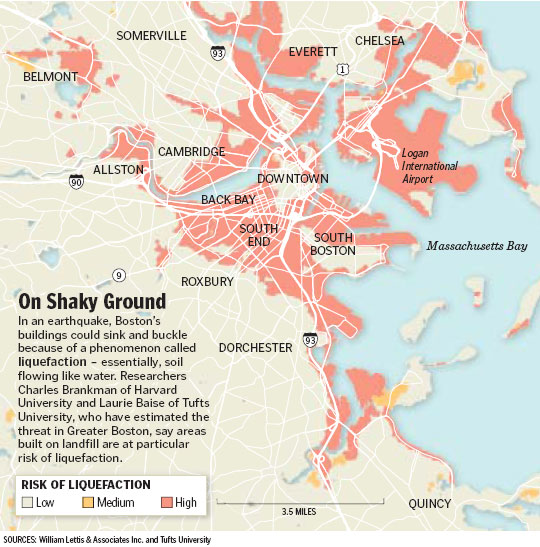
Not much has been done to address Boston's earthquake risk
1148501707_9931.jpg


since this Globe Magazine article in 2006
 
The Tunnels were built to handle a 7.0 , same with the Bridge and most skyscrapers in Boston...
 
The Tunnels were built to handle a 7.0 , same with the Bridge and most skyscrapers in Boston...

Which doesn't help you when one of those wood pilings that we don't know exactly where they are gets fucked up by an earthquake or something, which in turn triggers a cascading failure of all this 19th century infrastructure that we don't precisely know how it all interacts, nor do we know where all of it is.

But hey, that's okay, right? I mean, it's not like earthquakes are ever felt in Boston.
 
Right, I'm not saying do this instead of Red-Blue Connector.

Just the opposite, I'm saying do this because it stops Riverbank from becoming conflated with Red-Blue Connector - and, frankly, the Blue Line doesn't need to go to Kenmore. Rapid Transit needs to be restored to Watertown, but the Blue Line probably isn't the best way of doing that, and 50% of the demand problem evaporates immediately when you finally get Red-Blue done. (It's not a choice, Red-Blue must happen.)

But Red-Blue only solves part of the problem since the system would still rely on Park and Government Center to transfer Red and Blue passengers for all westbound service. Green Line traffic between Park and Government Center will certainly drop, but I don't think it's quite the cure-all that it is being painted. Not to say it isn't an absolute necessity - because it is - but Red-Blue only begins to address the hub-and-spoke issues the T network has.

I'm also not keen to leave the Blue Line to terminate at Charles/MGH because that means it will never be used to its full potential with gobs of excess capacity wasted throughout the day in the non-rush direction.

I'm also saying do this because you're never getting Heavy Rail B or E Lines, getting Heavy Rail C Line is something for Crazy Transit Pitches and Heavy Railing D precludes it from using the same tracks as B/C/E. The Park Street - Government Center tunnel is the biggest capacity constraint on the Green Line, and the D is the chief offender with regards to sucking up capacity. Move it onto the Riverbank, even without a Heavy Rail conversion, and suddenly you've got room to breathe - which you're going to need if you want to have a serious discussion about a full complement of north-side Green Line branches. (Chelsea says they want the Silver Line, but something tells me they'd be much happier with a Green Line branch. Everett could use a Green Line branch too.)

I am definitely with you that any thought of heavy rail on the current Green Line branches is wasted energy. There are several things that can be done to upgrade operations relatively easily instead: CBTC in the Central Subway, signal priority on the B/C/E branches, all 3-car operations on the B and D, etc. While moving the D to the Riverbank would help, you'd still have capacity crunches at Government Center and Kenmore where the diverted line would have to merge again. Also not sure how construction at those stations would happen without being incredibly disruptive to the entire system?
 
Which doesn't help you when one of those wood pilings that we don't know exactly where they are gets fucked up by an earthquake or something, which in turn triggers a cascading failure of all this 19th century infrastructure that we don't precisely know how it all interacts, nor do we know where all of it is.

But hey, that's okay, right? I mean, it's not like earthquakes are ever felt in Boston.

Well, liquefaction isn't going to to swallow up the Back Bay in a giant sinkhole. Generally speaking, what's in the fill is going to move with the fill like shaking a freshly-poured bowl of pudding with cookie crumbs in it. So there's very little risk of subway tunnels caving in or pilings snapping like twigs. And, remember, it's a pretty robust and overbuilt system of pilings so isolated damage isn't going to destabilize anything. The Back Bay isn't historically sinkhole-prone at all despite going through several 50-year flood events. If there were systemic ground support weakness it should have manifested itself periodically in those types of flood events, but that hasn't been the case. So I would say other than risk of loose debris of no more than a couple pounds getting jarred loose from a tunnel ceiling or a minor derailment from track-shifting the subway--and inside a subway car--is probably one of the safest places to be in an earthquake. That's proven true in the Bay Area with MUNI and BART.

Where Boston is at tippy-top extreme risk for damage is the buildings themselves: brick, masonry facades, masonry basements built before the days of rebar-reinforced concrete, wood-frame building supports susceptible to settling. A smaller quake than San Fran 1906 would cause even more-total destruction. Like, 70% of the buildings on Beacon, Marlborough, lower Comm Ave., and the cross streets gone...utterly gone, collapsed, beyond repair and whole blocks leveled off the face of the earth. With many more water/gas/sewer mains snapping like twigs because the large segments of 19th century piping under-street don't have the earthquake-resistant flexible joints that most West Coast cities retrofitted theirs with. Meaning, don't stand in the middle of Beacon...RUN to the Esplanade or Pru side of Boylston before things start asploding on every block.

The only things in Back Bay that'll withstand it well are new construction. The mostly-steel frame storefronts and buildings re-skeletoned behind old facades should make most of Boylston hold up decently well, as well as the few newer Newbury buildings (the rest of Newbury...fuck). And the modern offices, hotels, skyscrapers, and retail; Hynes, Hancock, and anything in the Pru complex or on Pike air rights...should suffer nary a scratch. Although the two churches are going to be giant piles of rubble.


Yeah...hopefully not in our lifetimes. Because when it happens it will be the most expensive and possibly highest loss-of-life natural disaster in U.S. history. That's not in doubt. But roads (except for the streets with asploding 19th century utilities), subways, and tunnels are definitely infrastructure of least concern.
 
So, what happens when something goes wrong with any part of this centuries-old setup? Everything breaks eventually. Are there contingencies in place, or is this 'well, let's just leave it well enough alone.

That's exactly what the plan is. It happened in Allston over the summer. Something blew and destroyed half the grid. Traffic lights and everything else electric went down for about a month on and off. They are still digging up the streets and replacing stuff. They tore up most of the main streets from union square to packards corner replacing everything,

Simmilar thing happened with that transformer fire in the back bay.

Follow the nour crumbling infastructuren posts on uhub, it documents it pretty well...

And every time something like this happens, it's a safe bet that the damages/costs are going to be orders of magnitude worse than if we'd invested in studying and documenting all this historic infrastructure, I take it?

Please tell me I'm not the only one who finds this to be a huge problem.
 
^ This isn't a local problem. Municipalities across the country are dealing with crumbling infrastructure from the last two centuries. The political will to get things updated generally doesn't occur until something big and bad happens to drive a lust for change. Like the bridge in Minnesota leading MassDOT to jump on rehabbing bridges across the state. Until something bad happens, it's out of sight, out of mind. A human condition and societal mass delusion...
 
And every time something like this happens, it's a safe bet that the damages/costs are going to be orders of magnitude worse than if we'd invested in studying and documenting all this historic infrastructure, I take it?

Please tell me I'm not the only one who finds this to be a huge problem.

Who's going to pay for it though? I don't want to tempt fate with a political war here (maybe this thread is split) but higher property taxes? A levy on utility bills? Special municipality fees?

I can't think of a single conservative who'd support an expansion of government to do this. We live in a media environment where it's no longer about logic or facts, it's about posturing. (Ironically enough a reconsituted WPA would be an informational investment into the future while providing jobs, today.)

Disaster response is one of the few mechanisms left to do exactly what you're asking about. NStar used the Back Bay disaster as an opportunity to square away a few other deferred/failing things as they cleaned up from the transformer problem.
 
http://www.addisonindependent.com/201210state-commits-rail-route-through-middlebury-2017

Now this is the kind of can-do spirit sorely lacking in MA. VTTrans says "Fuck it...we're goin' for it"--with or without fed funding commitment--on all track improvements necessary to extend the Ethan Allen Express from Rutland to Burlington by 2017. $45M that they'll pay in as small increments as it takes, and have roped in the freight stakeholders, towns, and colleges served by the line for full buy-in. The Ethan Allen is already a state-sponsored train, so Amtrak goes at their discretion. And the only thing they're likely to have to get Fed help on is stringing up PTC (which may not affect the '17 start date if that deadline's pushed out to '20).

I don't know whether to be hopeful or depressed that Vermont and Maine are totally running circles around us getting shit done on-budget and ahead of schedule with their own elbow grease. Makes you wonder if this face-to-face consensus-building thing might be worth a try, no?
 
I thought this was reasonable: a bus stop on each side of the crosswalk for the 132 route at the Stone Zoo. The bus runs right by it! It's the next closest zoo to Boston after Franklin Park and that would make it the second mass transit accessible zoo in the state. It's so damn simple, plant a sign!

http://www.google.com/maps?ll=42.462408,-71.091628&spn=0.00134,0.00284&t=h&z=19

Speaking of bus stops, Tremont Street at West Street needs to be moved back to the Park Street Station entrance at the corner of Park Street and Tremont Street.
 
Don't think there's room there. Once buses turn the corner on Tremont they'd be blocking the flow of pedestrians from Winter Street trying to get to the station (a flow that dwarfs the number of transfers between Park St and the 55 or 43). Once you get past the crosswalk, the Park Street headhouse itself is in the way, and once you move past that I think its just as well to have it at the top of the Parkman Plaza headhouse. There needs to be enough room to accommodate a 43 and a 55 at the same time.
 
? There is no stop at Tremont & West.

And there is at stop at the entrances to Park St, for the 43 and 53 routes.
 
http://www.addisonindependent.com/201210state-commits-rail-route-through-middlebury-2017

Now this is the kind of can-do spirit sorely lacking in MA. VTTrans says "Fuck it...we're goin' for it"--with or without fed funding commitment--on all track improvements necessary to extend the Ethan Allen Express from Rutland to Burlington by 2017. $45M that they'll pay in as small increments as it takes, and have roped in the freight stakeholders, towns, and colleges served by the line for full buy-in. The Ethan Allen is already a state-sponsored train, so Amtrak goes at their discretion. And the only thing they're likely to have to get Fed help on is stringing up PTC (which may not affect the '17 start date if that deadline's pushed out to '20).

I don't know whether to be hopeful or depressed that Vermont and Maine are totally running circles around us getting shit done on-budget and ahead of schedule with their own elbow grease. Makes you wonder if this face-to-face consensus-building thing might be worth a try, no?

This could be done quickly and easily to provide service to Cape Cod. The existing freight/dinner operation keeps looking to provide connecting service to Middleboro and is always rebuffed by MBTA.
 
This could be done quickly and easily to provide service to Cape Cod. The existing freight/dinner operation keeps looking to provide connecting service to Middleboro and is always rebuffed by MBTA.

While I don't think this really changes the calculus involving CCCR getting any permission from the T to run transfer service, it's interesting to note that Iowa Pacific LLC, a shortline holding company that runs a bunch of little carriers nationwide, just purchased an 80% ownership stake in Cape Rail last week, giving the carrier a bit more financial heft. The move is mainly for the MassCoastal freight arm, but Iowa Pacific also runs 8 different heritage RR's that loan historic equipment to each other. So the dinner train should make out very well in this deal.

The other rumor, floating on RR.net, is that CSX is strongly considering selling off more southeastern territory and perhaps ditching the Old Colony south of Braintree Yard and the Middleboro Secondary between Attleboro Jct. and Middleboro, letting MassCoastal run that whole region solo and shortening CSX's daily pickup runs to just a Readville-Braintree or Framingham-Attleboro quickie. Which would put MassCoastal operating pretty deep into T territory all the way up to Braintree, and possibly have them bidding on the currently expired freight rights to the Plymouth Line. Again, just a rumor...and it's come and gone before...but CSX's own employees are saying that the gears are turning on this and no doubt the Iowa Pacific stake has CSX's fingerprints all over it.


I would say this is good news in the long run. It definitely empowers CCCR to advocate for itself with a lot more heft. It just remains to be seen whether the T gives enough a crap. I think it would be GREAT if they ever could get permission to run a couple Braintree-Middleboro expresses in dead spots on the summer weekend MBCR schedule in addition to a fullish M'boro-Cape schedule. They wouldn't have the territorial rights allowing any permission to go all the way to South Station, but tapping the Red Line transfers at Braintree for a one-seat ride to the Cape would be the next-best thing to opening the Cape up to an influx of new ridership.
 

Back
Top