Red Line Extension to Mattapan

...and everyone will assign different values to the disutlity of walking, risking a missed connection, having to "get settled"/unsettled,
seat selection, and walking between vehicles. The models (accumulated experience) is that HRT and single seat rides attract users from farther away--people invest "a longer walk" for a "better total trip" payoff.

"Your mileage may vary" is a useful caveat

Another trade-off is whether you think more frequent HRT trains are more convenient (as a rider) or just more ambient noise (as an abutter)

Net-Net this seems like a win for both the locals in the immediate walk catchments AND a win for regional mobility via connections at Mattapan [& HRT Milton]
 
Last edited:
Well, I measure the cemetery ROW at 32 feet in Google Earth, and the Blue Line up by Suffolk Downs in the same range (trees make it a little hard, but they're both in the 30-35 range). So I doubt that.

They didn't study it and in their minds it's too late now, so Mattapan was obviously always going to get the Type 9s.

It drives me bonkers sometimes how MBTA planning simply ignores low-hanging fruit like this, or Orange-Roslindale, or Green-Upper Falls. But South Coast F-g Rail gets green-lit. Politics!

Going back to this, if anyone wants a more concrete width requirement for the Red Line, the median of the Longfellow Bridge is 27ft wide.
 
Well, I measure the cemetery ROW at 32 feet in Google Earth, and the Blue Line up by Suffolk Downs in the same range (trees make it a little hard, but they're both in the 30-35 range). So I doubt that.

The 27' Longfellow Bridge ROW is narrower than that, so the Red Line cars would definitely fit within the Mattapan line ROW.
 
What if we extend the Red Line to Milton, and then run Type 9 trains from Milton to Mattapan (and maybe continue the Type 9s along the 29 bus route (minus its Franklin Field Housing deviation) to Jackson Sq if sufficient transit reservations can be set aside in the streets)?

Alewife effectively uses one of its tracks to turn around Braintree trains and the other to turn around Ashmont trains, which suggests that a single track at Milton might be sufficient to turn around all trains, and if turning around every train that currently serves Ashmont on a single train at Milton isn't practical, sending only half the Ashmont trains to Milton and having the other half terminate at Codman Yard during rush hour would also be possible.

Single tracking a Milton terminus would simplify the interlocking there to a single switch, assuming double track was preserved from the Neponset River to Ashmont and beyond.

If we do this, I think we should also consider building a pedestrian underpass in the vicinity of Cedar Grove, and side platforms between Cedar Grove and Gallivan Blvd to serve both current Cedar Grove riders as well as to give Gallivan Blvd bus riders an opportunity to transfer to the Red Line; a road diet of Gallivan Blvd at the same time may be desirable as well.

There isn't nearly enough facilities space to extend the line to street-running. The line runs on an 8-car fleet. You can't maintain something much larger than that at Mattapan shed or some LRV-serving replacement shed in the corner of Codman Yard. So unfortunately 28X is pretty firmly in the BRT category as best available option, because even though Blue Hill Ave. once had a trolley reservation that shared yards with the HSL...it also had an Arborway Carhouse connection on the other end that kept the fleet requirements well-distributed. And that doesn't exist today, nor is there space for it.

N-O! on single-tracking anything. No rapid transit operation in Boston runs on low-enough margins for its frequencies--including the existing HSL--to survive with only 1 track. Braintree and Ashmont can and do appear on either Alewife track when conditions warrant, even when most of the time they stick to the same side for wayfinding sanity. It's not foolproof; ops needs chaos-absorbing flexibility at turnbacks at any given moment.

Extending the Red Line to Mattapan in-full is not a big production. The two required grade crossing eliminations are not big productions. The state simply doesn't want to spend a dime more than it's forced to kicking-and-screaming on the corridor, and they have tried to bury it enough times prior that the residents have so much pent-up mistrust that public support is guided in large part by what prevents another chance at transit loss. Support would probably be higher for the HRT option if they had any indication the state was dealing with them in any plausible honesty over it...but the state pretty much spit all over that option. If accepting Type 9's is what keeps the dreaded bustitution talk tabled for another 20 years, that's where the widest share of support gravitates. It's not because they think that's 'best'...they know they can do better, and that includes fact that the trolleys could run a whole lot more frequent than the CAF's propping up the same not-very-frequent headways as the PCC's. But it is 'safest' pick when they haven't gone more than 10 years without dodging a bullet on major existential threat of transit loss.

Hopefully the next debate after this punt the conversation will actually pivot to what's a greater transit deal for the corridor, but right now those residents can be forgiven for still treating it like survival mode.
 
Hooray! The quirky little trolley line on the edge of the city survives. And BTW the title of the thread doesn't make sense, the Red Line already goes to Mattapan you are just forced to take a really cool vintage trolley to get there.
 
Hooray! The quirky little trolley line on the edge of the city survives. And BTW the title of the thread doesn't make sense, the Red Line already goes to Mattapan you are just forced to take a really cool vintage trolley to get there.
This is a less relevant question- but will the recycled green line trolleys be green? Or will there be some plan to paint red or orange?
 
This is a less relevant question- but will the recycled green line trolleys be green? Or will there be some plan to paint red or orange?

I don't think they've said. The Type 9s would probably get some sort of mid-life overhaul between service on Green and Red, so it seems logical to recolor them at that point. I suspect the community would ask for it.

Could make a good case to just rebrand the Mattapan HSL as the Pink Line and put the Type 9s in that color. The line serves two CBDs (Mattapan and Milton), after all.
 
Didn't they just build that loop in the last ten years or something? But yeah, if the Type 9s can't handle the turn, then the Type 9s can't handle the turn and that's that.
 

“The existing bridge structure at Ashmont, sometimes referred to as a viaduct, cannot support the “Type 9,” due to the turn radius and length of the vehicles, so it must be torn down, the officials said at the virtual meeting. Additionally, the “Type 9” trains can move in both directions, so they do not need to complete a loop in order to turn around.

The T is weighing two options: Removing the current bridge and rebuilding it at an elevated level, or removing it and putting a new passenger platform for the trolley at ground level with the Red Line trains, meaning passengers can connect to and from the Red Line without going up and down a set of stairs, as they currently do.

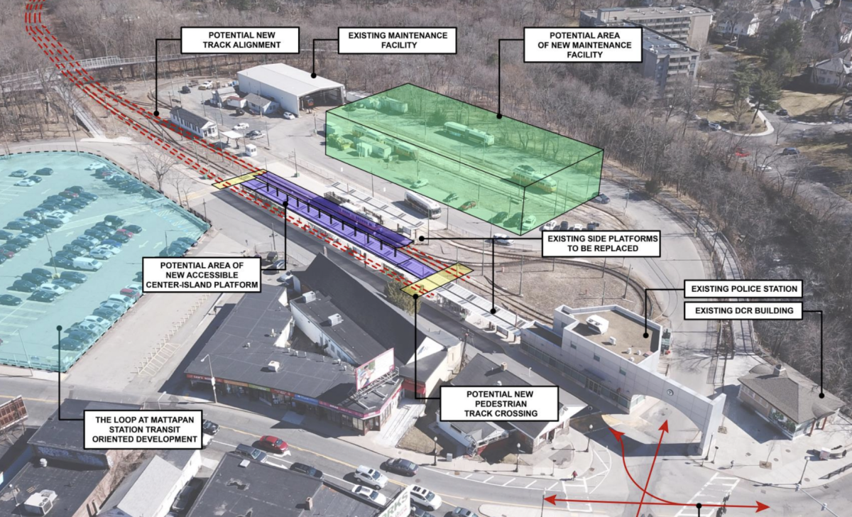
At the Mattapan Square terminus for the trolley, the tracks are already at-grade but there is still a significant amount of work, according to T officials. Buses come in, the MBTA Police have a building there, and is the storage and maintenance location of the Mattapan line. The MBTA’s overhaul of the trolley lines calls for a new maintenance facility at the station.

The plans for Ashmont and Mattapan Stations remain under development, due to the complexities involved, more so than the simpler stations between Ashmont and Mattapan Square.

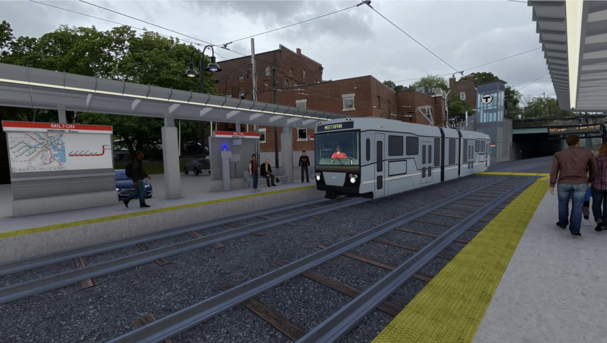
The Tuesday meeting also included renderings of plans for the Milton and Central Avenue stations. At the Milton stop, the inbound and outbound platforms would be kept at the same locations due to the space restrictions in the area. But Milton would see the same improvements as the other stations: Wind screens, seating, an emergency call box and canopies above people’s heads. The other stations are slated to be center-island platforms.

One addition to Milton that the other stations won’t see is an elevator, which would replace the already-demolished stairs from Adams Street. The demolishment of the stairs earlier this year enraged Milton officials, who noted the stairs had been closed for nearly a decade after falling into disrepair.

Aside from the elevator, passengers will also have the option of a sloped walkway from Adams Street, according to AJ Tanner, one of the MBTA officials at the Tuesday meeting.

Milton stop rendering.png
A rendering of the Milton stop on the Mattapan line. (Image via MBTA)

Mattapan loop.png
The MBTA also plans to overhaul the Mattapan Square station loop. (Image via MBTA)

- Definitely sounds like an upgrade having the trolleys either at a platform next to red at ground level, or above red and at grade with the bus turnabout.
I like this conversion plan. I would extend it up Blue Hill Ave, Seaver Street and Columbus Ave to the OL Jackson Sq station.
 
“The existing bridge structure at Ashmont, sometimes referred to as a viaduct, cannot support the “Type 9,” due to the turn radius and length of the vehicles, so it must be torn down, the officials said at the virtual meeting. Additionally, the “Type 9” trains can move in both directions, so they do not need to complete a loop in order to turn around.

The T is weighing two options: Removing the current bridge and rebuilding it at an elevated level, or removing it and putting a new passenger platform for the trolley at ground level with the Red Line trains, meaning passengers can connect to and from the Red Line without going up and down a set of stairs, as they currently do.

At the Mattapan Square terminus for the trolley, the tracks are already at-grade but there is still a significant amount of work, according to T officials. Buses come in, the MBTA Police have a building there, and is the storage and maintenance location of the Mattapan line. The MBTA’s overhaul of the trolley lines calls for a new maintenance facility at the station.

The plans for Ashmont and Mattapan Stations remain under development, due to the complexities involved, more so than the simpler stations between Ashmont and Mattapan Square.

The Tuesday meeting also included renderings of plans for the Milton and Central Avenue stations. At the Milton stop, the inbound and outbound platforms would be kept at the same locations due to the space restrictions in the area. But Milton would see the same improvements as the other stations: Wind screens, seating, an emergency call box and canopies above people’s heads. The other stations are slated to be center-island platforms.

One addition to Milton that the other stations won’t see is an elevator, which would replace the already-demolished stairs from Adams Street. The demolishment of the stairs earlier this year enraged Milton officials, who noted the stairs had been closed for nearly a decade after falling into disrepair.

Aside from the elevator, passengers will also have the option of a sloped walkway from Adams Street, according to AJ Tanner, one of the MBTA officials at the Tuesday meeting.

Milton stop rendering.png
A rendering of the Milton stop on the Mattapan line. (Image via MBTA)

Mattapan loop.png
The MBTA also plans to overhaul the Mattapan Square station loop. (Image via MBTA)

- Definitely sounds like an upgrade having the trolleys either at a platform next to red at ground level, or above red and at grade with the bus turnabout.
That loop went into design in 2001, more than 3 years after the identical-dimension Type 8's had started being delivered. And they didn't anticipate any future-proofing incompatibility back then?!?!? What a crock.

Figures that the do-over would try to undo the worst downgrade from the old Ashmont to the new (years late and morbidly overbudget) Ashmont: the way inferior transfer interface between Red and the trolleys. It used to be such a simple and effortless cross-platform transfer.
 
Here's an artists rending of what that might look like. If only it were possible...
It is possible. All those streets (the Blue Hill Ave, Seaver Street, and Columbus Ave route) are wide enough to fit in a center reservation for LRV.

IMO it's low hanging fruit that would provide maximum service to a densely populated underserved area,
 
It is possible. All those streets (the Blue Hill Ave, Seaver Street, and Columbus Ave route) are wide enough to fit in a center reservation for LRV.

IMO it's low hanging fruit that would provide maximum service to a densely populated underserved area,

This would be awesome and serve communities that don't have the best access to non-bus transit. I loved watching this video. Is the "reservation" at the edge of Franklin Park still there? Is it owned by the MBTA?
 
Is the "reservation" at the edge of Franklin Park still there?
It's hard to tell, but in that footage it looks like Seaver street was narrower. So I think the "reservation" the streetcar used was lost to widen the street. The streetcar path is now Seaver St. eastbound, plus a lane of car parking.
 
It's hard to tell, but in that footage it looks like Seaver street was narrower. So I think the "reservation" the streetcar used was lost to widen the street. The streetcar path is now Seaver St. eastbound, plus a lane of car parking.
Yes that is the case. Here is a before and after of Seaver St. Great (older- I think some links are getting lost) web site on street car suburbs of Boston Street Car
Untitled.png
 

Back
Top