- Joined
- May 25, 2006
- Messages
- 7,034
- Reaction score
- 1,875
For those of you who haven't heard of it, the Urban Ring is a transit plan put out by the MBTA to connect all the transit lines (subway, bus, and commuter rail) that come into downtown Boston with a ring of transit. The purpose of this is two fold; the first being to take pressure off of the 4 major downtown transfer points (Park, State, Gov't Center, and DTX), and second to connect large job centers, primarily Kendall Sq and the Longwood Medical Area. The current plan is a three phase process starting with improved crosstown bus service, then moving to Bus Rapid Transit -BRT- (e.g. Silver Line), and finally constructing a subway line either using Orange Line heavy rail or Green Line light rail.
The idea for an urban ring is not new. The first instance of a transit line encircling Boston was put out by Robert Gourlay, a Scottish writer and urbanist. When he first came to the young United States in 1817 he realized that the new nation would be building many new cities and that there had to be a scientific way to do so. He began crafting ideas for cities, making him one of the first urban planners. In his "General Plan, for enlarging and Improving the City of Boston", Gourlay proposed something completely radical: fill in the Back Bay and line the Charles River with a park and train line. He also proposed connecting the Providence, Boston & Worcester, and Fitchburg train terminals with underground tunnels (we don't have this either). Nothing came of Gourlay's plan, though he must have planted a few seeds in the minds of Bostonians.
(I mean to have an image of Gourlay's plan but I can't find it online. You can see it in the book "Inventing the Charles River" by Karl Haglund)
The problem most people have with the current plan is that it doesn't serve enough areas and that it relys mainly on slow moving buses in mixed traffic. I do want to go on record saying that I am all for improved crosstown bus
service but I am not for relying completely on buses. I do believe that any serious transit plan needs to take them into account and to propose ideas that would improve bus traffic (dedicated lanes), but in the end any urban ring proposal needs to center around an actual subway line. Here is my proposal:
To start with, this is not just a proposal for the urban ring but it is a fundamental rethinking of how the Green Line would operate.
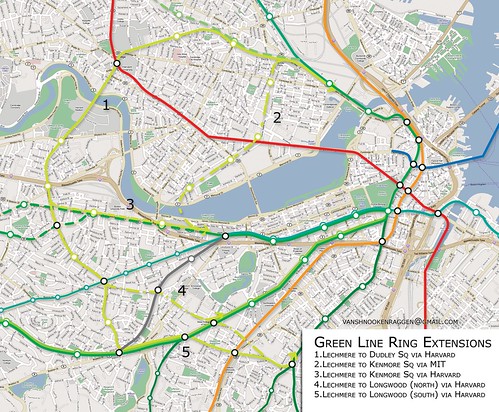
What this map shows is a series of rings formed by connecting the ends of the Green Line through Cambridge and Boston. The Green Line as we know it today would function as half of the ring while the other half could go through Harvard and Allston (#1) or Kendall Sq (#2). Since the southern end of the Green Line has multiple branches this gives us more options for where to connect the ring. The first connection would be to Kenmore Sq (#3), either directly under the Charles River or by a new tunnel under Comm. Ave. The next possibility would be under Huntington Ave (#4), connecting Longwood into the ring. The last option would be the most dramatic, connecting the ring to Dudley Sq (#5) where a new tunnel under Washington St would connect the ring into downtown.
What would happen to the trolley service we have now is this:
- B Line would be placed in a tunnel to Brighton where it could terminate or continue to Boston College.
- C Line would cease going to North Station but would instead travel to South Boston via a new tunnel under Essex St (what Silver Line Phase III is planning on building).
- D Line would connect to the Huntington Ave subway and shuttle service would be instituted along the stretch of track connecting Brookline with Kenmore Sq.
- E Line would be truncated or switched to Washington St tunnel.
If two of the connections were built then this would give the T much more room to try different services and to reroute trains if one becomes disabled.
The next phase would be to connect the northeastern suburbs.
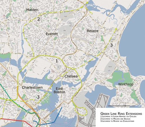
Unlike the first phase, these lines would only feed into the new urban ring tunnels, not the Green Line tunnels.
The three options as thus: Construct a new line, both in tunnel and at grade, to connect Lechmere with Everett, Chelsea, and Logan Airport (#1). This proposal is currently in the long term plans for the actual Urban Ring but only as BRT. The next would be to use the under-used Saugus Branch ROW that runs along Everett to Malden and Saugus before terminating in Lynn (#2). Service here could terminate at a Park-&-Ride facility at the interchange at Route 1 or continue to Saugus and Lynn. The last options is a line through Charlestown in a tunnel to Chelsea and on to Revere (#3). This would be the most expensive since express bus service covers this basic route today, but I just threw it in there anyway.
All of these new lines running through the central subway would put tremendous pressure on an already crowded system. The most important part of this whole rethinking is to rebuild the central subway.
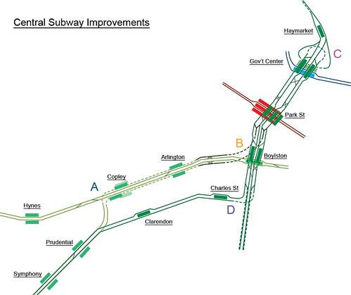
This is probably a good idea regardless of whether any ring lines are added. What you see here is a track diagram of what the central subway could look like (click here to see what it looks like today).
Here's what would happen:
We would take pressure off the Boylston St tunnel by redirecting D and E branch traffic by one of two ways:
A - Build a new tunnel under the current Boylston St tunnel, eliminating the Copley Junction which is the major choke point in the Green Line (all B and C trains need to stop so an E can pass first). There would be new platforms under Copley station but no new platforms at Arlington.
OR
D - Eliminate the Copley Junction by building a new tunnel under Stuart St through the Back Bay. This new subway would have two new stations and connect to the central subway using the abandoned tunnels south of Boylston St station.
Both of these plans envisions the D branch connecting to the Huntington Ave subway which itself would be extended under Huntington Ave to Brookline.
All of this hinges on the most important element of the plan,
B - Completely rebuild the Boylston St junction and station. Build two tracks that bypass the station and go directly to Park St (lines in black). Also take the two tracks that are there now and drive them under the current station, creating a new platform. This tunnel would then continue to South Station and on to South Boston, there by connecting the hotels, offices, and convention center of the new SBW with the hotels, offices, and convention center of the Back Bay (through the Financial District!) A new Boylston St Upper station would then serve all traffic either from Newton and JP (via the rerouted D and E branches) and/or a new tunnel under Washington St to Dudley Sq (and beyond!)
The last part of the plan is to correct a problem that the Green Line has suffered from since it's inception.
C - Build a second, two track tunnel from Park St to Government Center. Rebuild GC with two parallel platforms and a new loop for the outer tracks, while the inner tracks continue to Haymarket. The Brattle Loop would be sunk and a new platform for the Blue Line would allow passengers from the Blue Line to connect directly northbound Green Line service, which will undoubtedly pick up after the West Medford extension is completed.
----------
This is no simple plan and will most certainly cost billions of dollars. But if you only think about it in terms of how much it's going to cost you then you aren't seeing the forest for the trees. The Green Line today is a relic of Victorian era transportation and it is evident every time you ride it. Installing a brand new artery that doesn't funnel people in and out of the city twice a day but circulates them throughout the business areas, residential areas, and entertainment areas will completely change the way people think about living in the city.
The problem with the current plan for the Urban Ring is that it still clings to the transportation theories of the mid 20th century where people come in from the suburbs at 8am and then leave at 5pm. While there will always be commuting into the city, the city cannot grow and prosper when this is the only option. We need a new way of thinking about how mass transit can strengthen a city and I think that these proposals are a good first step.
----------
Well, that's my plan, what are some of your ideas?
The idea for an urban ring is not new. The first instance of a transit line encircling Boston was put out by Robert Gourlay, a Scottish writer and urbanist. When he first came to the young United States in 1817 he realized that the new nation would be building many new cities and that there had to be a scientific way to do so. He began crafting ideas for cities, making him one of the first urban planners. In his "General Plan, for enlarging and Improving the City of Boston", Gourlay proposed something completely radical: fill in the Back Bay and line the Charles River with a park and train line. He also proposed connecting the Providence, Boston & Worcester, and Fitchburg train terminals with underground tunnels (we don't have this either). Nothing came of Gourlay's plan, though he must have planted a few seeds in the minds of Bostonians.
(I mean to have an image of Gourlay's plan but I can't find it online. You can see it in the book "Inventing the Charles River" by Karl Haglund)
The problem most people have with the current plan is that it doesn't serve enough areas and that it relys mainly on slow moving buses in mixed traffic. I do want to go on record saying that I am all for improved crosstown bus
service but I am not for relying completely on buses. I do believe that any serious transit plan needs to take them into account and to propose ideas that would improve bus traffic (dedicated lanes), but in the end any urban ring proposal needs to center around an actual subway line. Here is my proposal:
To start with, this is not just a proposal for the urban ring but it is a fundamental rethinking of how the Green Line would operate.
What this map shows is a series of rings formed by connecting the ends of the Green Line through Cambridge and Boston. The Green Line as we know it today would function as half of the ring while the other half could go through Harvard and Allston (#1) or Kendall Sq (#2). Since the southern end of the Green Line has multiple branches this gives us more options for where to connect the ring. The first connection would be to Kenmore Sq (#3), either directly under the Charles River or by a new tunnel under Comm. Ave. The next possibility would be under Huntington Ave (#4), connecting Longwood into the ring. The last option would be the most dramatic, connecting the ring to Dudley Sq (#5) where a new tunnel under Washington St would connect the ring into downtown.
What would happen to the trolley service we have now is this:
- B Line would be placed in a tunnel to Brighton where it could terminate or continue to Boston College.
- C Line would cease going to North Station but would instead travel to South Boston via a new tunnel under Essex St (what Silver Line Phase III is planning on building).
- D Line would connect to the Huntington Ave subway and shuttle service would be instituted along the stretch of track connecting Brookline with Kenmore Sq.
- E Line would be truncated or switched to Washington St tunnel.
If two of the connections were built then this would give the T much more room to try different services and to reroute trains if one becomes disabled.
The next phase would be to connect the northeastern suburbs.
Unlike the first phase, these lines would only feed into the new urban ring tunnels, not the Green Line tunnels.
The three options as thus: Construct a new line, both in tunnel and at grade, to connect Lechmere with Everett, Chelsea, and Logan Airport (#1). This proposal is currently in the long term plans for the actual Urban Ring but only as BRT. The next would be to use the under-used Saugus Branch ROW that runs along Everett to Malden and Saugus before terminating in Lynn (#2). Service here could terminate at a Park-&-Ride facility at the interchange at Route 1 or continue to Saugus and Lynn. The last options is a line through Charlestown in a tunnel to Chelsea and on to Revere (#3). This would be the most expensive since express bus service covers this basic route today, but I just threw it in there anyway.
All of these new lines running through the central subway would put tremendous pressure on an already crowded system. The most important part of this whole rethinking is to rebuild the central subway.
This is probably a good idea regardless of whether any ring lines are added. What you see here is a track diagram of what the central subway could look like (click here to see what it looks like today).
Here's what would happen:
We would take pressure off the Boylston St tunnel by redirecting D and E branch traffic by one of two ways:
A - Build a new tunnel under the current Boylston St tunnel, eliminating the Copley Junction which is the major choke point in the Green Line (all B and C trains need to stop so an E can pass first). There would be new platforms under Copley station but no new platforms at Arlington.
OR
D - Eliminate the Copley Junction by building a new tunnel under Stuart St through the Back Bay. This new subway would have two new stations and connect to the central subway using the abandoned tunnels south of Boylston St station.
Both of these plans envisions the D branch connecting to the Huntington Ave subway which itself would be extended under Huntington Ave to Brookline.
All of this hinges on the most important element of the plan,
B - Completely rebuild the Boylston St junction and station. Build two tracks that bypass the station and go directly to Park St (lines in black). Also take the two tracks that are there now and drive them under the current station, creating a new platform. This tunnel would then continue to South Station and on to South Boston, there by connecting the hotels, offices, and convention center of the new SBW with the hotels, offices, and convention center of the Back Bay (through the Financial District!) A new Boylston St Upper station would then serve all traffic either from Newton and JP (via the rerouted D and E branches) and/or a new tunnel under Washington St to Dudley Sq (and beyond!)
The last part of the plan is to correct a problem that the Green Line has suffered from since it's inception.
C - Build a second, two track tunnel from Park St to Government Center. Rebuild GC with two parallel platforms and a new loop for the outer tracks, while the inner tracks continue to Haymarket. The Brattle Loop would be sunk and a new platform for the Blue Line would allow passengers from the Blue Line to connect directly northbound Green Line service, which will undoubtedly pick up after the West Medford extension is completed.
----------
This is no simple plan and will most certainly cost billions of dollars. But if you only think about it in terms of how much it's going to cost you then you aren't seeing the forest for the trees. The Green Line today is a relic of Victorian era transportation and it is evident every time you ride it. Installing a brand new artery that doesn't funnel people in and out of the city twice a day but circulates them throughout the business areas, residential areas, and entertainment areas will completely change the way people think about living in the city.
The problem with the current plan for the Urban Ring is that it still clings to the transportation theories of the mid 20th century where people come in from the suburbs at 8am and then leave at 5pm. While there will always be commuting into the city, the city cannot grow and prosper when this is the only option. We need a new way of thinking about how mass transit can strengthen a city and I think that these proposals are a good first step.
----------
Well, that's my plan, what are some of your ideas?
