You are using an out of date browser. It may not display this or other websites correctly.
You should upgrade or use an alternative browser.
You should upgrade or use an alternative browser.
Seaport Square (Formerly McCourt Seaport Parcels)
- Thread starter briv
- Start date
I have a feeling when all three of these projects get built out, this should be a pretty vibrant area. It may be architecturally stale, but at least it wont be like it is now, barren and windswept.
The one thing I am concerned with, and I know it has been mentioned, is that the mass transit to this location is marginal, at best. Where is the investment to improve it? Your adding all those residences and businesses and not one mention of improving the infrastructure.
The one thing I am concerned with, and I know it has been mentioned, is that the mass transit to this location is marginal, at best. Where is the investment to improve it? Your adding all those residences and businesses and not one mention of improving the infrastructure.
underground
Senior Member
- Joined
- Jun 20, 2007
- Messages
- 2,390
- Reaction score
- 3
Coco and Papelbon live in the building with LTK!No worries ... no one actually lives in the Waterfront ... ;-)
pelhamhall
Active Member
- Joined
- Jan 4, 2008
- Messages
- 855
- Reaction score
- 0
RE: "Papelbon and Coco live in those buildings"
Not anymore! The Herald reported that Papelbon moved out and the quoted him saying that living in Park Lane is like "living in Siberia" - a total embarrassment for the Park Lane team. Especially since they always tout how Red Sox players live there. Ooops! They better take that detail out of their sales pitch.
You have to pay to see the article but this is the credit:
Boston Herald; Apr 23, 2007 - you can google "Papelbon, Siberia" to get it.
Joe_Schmoe
Active Member
- Joined
- May 25, 2006
- Messages
- 374
- Reaction score
- 0
A new thing I noticed. Why don't they continue the streetwall down Sumner St at the roofline of the courthouse.
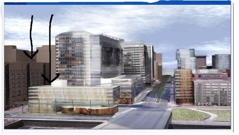
Why does the lowrise portion of that building sink so much lower than the roofline of the courthouse across the street? That is not the way to create an effective streetwall.
And finally, if the name of this area is to be Seaport Sq, don't you think there should be some sort of recognition that they are near the water. These buildings could really be placed anywhere (to me they look like modern examples of the awful brown apartment towers at the Prudential).
kz1000ps
Senior Member
- Joined
- May 28, 2006
- Messages
- 9,187
- Reaction score
- 13,721
Joe Schmoe, usually I'd agree with you on this issue, but Northern Ave isn't terribly wide. I'd say the height of the proposed building is more correctly scaled to the road than the courthouse.
It looks like you would need about 12 floors of residential to meet the 7-story height of the court, possibly becoming a target of NIMBYs who feel it's too much bulk at the entrance to the site. Also, it would blur the distinction between the tower and base to the point that it'd look a lot more ungainly IMO.
It looks like you would need about 12 floors of residential to meet the 7-story height of the court, possibly becoming a target of NIMBYs who feel it's too much bulk at the entrance to the site. Also, it would blur the distinction between the tower and base to the point that it'd look a lot more ungainly IMO.
Ron Newman
Senior Member
- Joined
- May 30, 2006
- Messages
- 8,395
- Reaction score
- 14
Seems to me that once you have buildings of five stories or higher, you have a streetwall. What's most important is not uniformity of additional height, but the uses found on the street level.
R
Riverworks
Guest
I'm still trying to go to this meeting tonight ... anyone else care to join?
Joe_Schmoe
Active Member
- Joined
- May 25, 2006
- Messages
- 374
- Reaction score
- 0
I disagree Ron. Think of how the symmetry of the heights on each side of the street contribute the effectiveness of these streetscapes (photos by ablarc):


JimboJones
Active Member
- Joined
- Apr 4, 2007
- Messages
- 935
- Reaction score
- 1
I have seen the future!
And, it's NOT a parking lot!
And, it's NOT a parking lot!
JimboJones
Active Member
- Joined
- Apr 4, 2007
- Messages
- 935
- Reaction score
- 1
Re: Seaport Square photos (warning, lots of 'em)

Facing Boston Harbor in distance, Seaport Hill park in closest, then Autumn Blvd, then a public park (ice skating, farmers' market, concerts)

Looking toward Financial District, Seaport Blvd in middle

From Harbor, Courthouse to the right

Madison Seaport Hotel at top w/ exhaust

Public park, Boston Harbor to left

Seaport Blvd, trees promised for center

Seaport Blvd

More

Etc

Ergo

Ad nauseum

...

ditto

as i was saying

::30::
Facing Boston Harbor in distance, Seaport Hill park in closest, then Autumn Blvd, then a public park (ice skating, farmers' market, concerts)
Looking toward Financial District, Seaport Blvd in middle
From Harbor, Courthouse to the right
Madison Seaport Hotel at top w/ exhaust
Public park, Boston Harbor to left
Seaport Blvd, trees promised for center
Seaport Blvd
More
Etc
Ergo
Ad nauseum
...
ditto
as i was saying
::30::
kz1000ps
Senior Member
- Joined
- May 28, 2006
- Messages
- 9,187
- Reaction score
- 13,721
A couple questions for Jimbo or anyone who went:
Did they show a diagram showing land uses? I'm curious as to where the various components are, such as the hotels, private school and retail areas.
All that green on the roofs -- will they actually be green roofs or is that just marketing BS?
Did they show a diagram showing land uses? I'm curious as to where the various components are, such as the hotels, private school and retail areas.
All that green on the roofs -- will they actually be green roofs or is that just marketing BS?
JimboJones
Active Member
- Joined
- Apr 4, 2007
- Messages
- 935
- Reaction score
- 1
This was undoubtedly the most uneventful community meeting probably anyone's ever been to.
Briefly, here's what went down.
There seemed to be a good number of guys in ties, not sure where they were all from, although someone from Morgan Stanley was there (bankers) and the development team, and an architect or two, and Mr Hynes, of course.
The topic of the night was "public realm" which sort of meant, where will people be expected to be, once the project is completed, say, in 2015. They ran a five minute video which showed where the three major parks will be. Seaport Hill, surrounded by mostly residential, the public park, and a pathway closed off to traffic, in between. These all lead to the Harbor park, around Fan Pier (not part of Gale Int'l project).
I didn't take any notes, so this is from memory.
They talked for maybe 40 minutes. I have to say, no disrespect, but, I've now heard John Hynes talk twice, and he's not the most charismatic speaker. He doesn't really get the crowd going. Which, to a certain extent, is good - he's no salesman. Seems to come across as sincere, if not inspired. But, I've never seen him angry who knows?
They opened the floor up to questions.
The first guy to talk was from South Boston. His name is Jay Hurley? He said he was third generation South Boston. Is he related to "Wacko" Hurley? No, seriously.
He gave a very impassioned speech supporting the project, mostly for the benefits to be had by union ironworkers, etc. He said, "I probably couldn't afford to live there, but that's not what's important." He said a lot of other stuff which, of course, I totally supported.
I think his comments kind of quieted the crowd down - no one spoke up against anything. It was well-attended, but I didn't get the feeling that anyone there was against it.
[I edited this part ...]
Except for Vivien Li, who basically wondered how much parking would be included.
She also said that she noticed that there seemed to be a lot of density in the parcel around where the Barking Crab and Courthouse were located. She suggested, "Also, the way that one building is situated - we'd like you to turn it around."
I figured there was no sense keeping quiet, so I raised my hand and basically asked, "Don't you really need MORE parking, not less?"
Interesting point - One Lincoln Center, according to Mr Hynes, has 1 million square feet of space, in one building. The entire Seaport Square development will have 1.25 million square feet of office space, spread across multiple buildings. And, One Lincoln Center has 5,000 employees, so to interpolate, Seaport Square would have 6,250 workers.
So, on that basis, it really doesn't seem very dense. Some of the buildings are as high as 140'. Don't know the breakdown, and, of course, it's all subject to change.
They plan on building three buildings, at first. And, closest to Northern Ave bridge, from what I believe they said. A residential, office, and I don't know the third - I would assume a hotel. Diane Kelliher (also a real estate agent) asked a question. She lives at Channel Center. She wanted to know if the developer would be building residential, first. Of course she would want to know this, because they promised a whole lot of development down at Channel Center, and then pulled the plug, after the first building (two, really) was built. Now they live in a vast wasteland.
They explained that their plan depended on each element being built at the same time - office, hotel, retail, and residential. One can't be successful without the other. Don't know if that's true, but they're the experts.
They hope to break ground at the end of the year. They do not have any permits or anything at this point, however. The BRA representative said something along the lines of, "Well, if we're not going to get any opposition, we should be able to move right along."
Their next meeting is in two weeks, in South Boston. The topic is traffic, which will undoubtedly be a bit more contentious.
Oh, once they have the first three buildings in the ground, they would plan on building the massive parking garage. It will be under a lot of the buildings, basically from the Harbor to Summer Street (well, a bit of an exaggeration, perhaps). I guess, continuous?
Currently, there are 3,700 parking spaces. They will add 800 to that total, for retail / hotel / office workers, and have 2,000 for residents.
Project is a total of 6.5 million square feet, 2.65 million of residential across 2,500 units of housing (apartments, condos), 1.25 million square feet of office space, 500,000 square feet of hotel space (700 "keys"), 600,000 square feet of cultural & educational space (remember, they are proposing a school).
And, that's about it.
Last edited:
Ron Newman
Senior Member
- Joined
- May 30, 2006
- Messages
- 8,395
- Reaction score
- 14
What are their plans for the Courthouse Silver Line station? Will they add the additional entrances that the station's current design presumes? Will a building absorb the existing entrances?
stellarfun
Senior Member
- Joined
- Dec 28, 2006
- Messages
- 5,726
- Reaction score
- 1,586
^^^ on parking, and not wanting to sound like Vivien, but was there any discussion about how all this additional parking for the Fan Pier, Seaport, Waterside, etc., will be squeezed in given the cap on off-street parking spaces in Boston? Has the city and the various developers divvied up what's available in the 'bank'?
http://www.cityofboston.gov/environment/status.asp
The South Boston Parking Freeze Area, as established in 310 CMR 7.33, shall be divided into three zones defined as: 1) the South Boston Piers Zone; 2) the South Boston Industrial/Commercial Zone; and 3) the South Boston Residential Zone. The geographic boundary of each zone is as follows:
THE SOUTH BOSTON PIERS ZONE: beginning at the point where Mount Washington Street meets the high water line of the Fort Point Channel and continuing in a westerly direction to the center point of the Channel; then northeasterly along the imaginary center line of the Channel to the Boston Inner Harbor; then continuing southeasterly along the high water line to the southern center point of the Reserved Channel and continuing westerly in a straight line along the Channel direction to a point where it meets Summer
Street; then following Summer Street in a northwesterly direction to a point where it meets Fargo Street; then following Summer Street in a northwesterly direction to a point along Fargo Street where it meets B Street; then westerly along an imaginary straight line back to the point where Mount Washington meets the high water line.
Latter cite here:The South Boston parking freeze allows a maximum of 30,147 non-residential parking spaces in South Boston. In 2005, there were approximately 70 parking facilities in South Boston, and approximately 2,000 spaces in the parking freeze bank, which can be allocated to new parking facilities. The actual number of facilities and spaces fluctuates as old parking lots close and new ones open. The APCC welcomes and encourages informal inquiries from owners and developers. Residential parking spaces are largely-though not completely-excluded from the freeze.
http://www.cityofboston.gov/environment/status.asp