The Northeast Expressway, Revere Beach Connector, and geographically related projects

BostonUrbEx

Senior Member
Joined
Mar 13, 2010
Messages
4,340
Reaction score
127
I'll be dumping random "scans" (me using a camera due to lack of a scanner in the Transportation Library) here of plans and pictures I've found concerning the I-95 Northeast Expressway, Revere Beach Connector, MA-1A, MA-107, MA-60 and anything else that fits in.


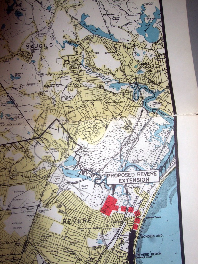
First up, the first plan I've ever found of the Revere Beach Connector:

6387145751_644e45cbb6_b.jpg


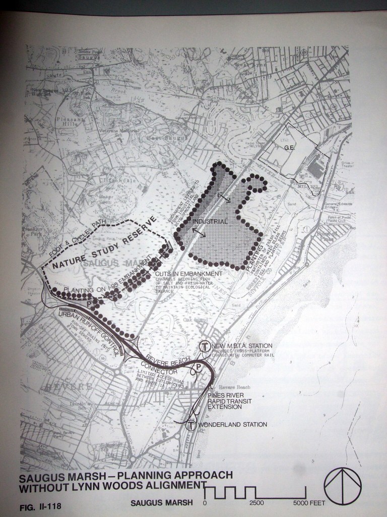
Note how this plan is a part of the I-95 cancellation, ceding the roadbed for 95 over to industrial uses and a recreational loop through the marsh.
 
Last edited:
Here's something which I think might be a bit older:

6386990839_78ca0eb9ec_b.jpg


Note the I-95 alignment is visible, as well as some unknown highway skirting past Wonderland and the proposed Blue Line extension to MA-107. I have no idea what this highway is, and I will have to try to find this plan again to see where it came from.
 
6386891633_333e9deec4_b.jpg


^ Looking north on the southbound bridge for the proposed I-95 on the southerly side of Copeland Circle. The sign on the right was over the northbound split and says "RTE C-1, So. Lynnfield, N.H. - Maine". Another sign to the right would announce I-95 and the Revere Beach Connector.


6386894025_73e4f2bacd_b.jpg


^ Looking north in the northbound lanes of the expressway. The signs ahead direct drivers left for "Rte. C-1, So. Lynnfield, N.H. - Maine" or right for "Lynn, Revere Beach". C-1 is the present day US-1 which is in use. The split to the right was for the planned I-95 and Revere Beach connector.
 
What book(s) are these coming out of?

I own the 1962 inner belt/Route2/3/16 plans and 1948 master plan. I've been trying to find the statewide 1968 plan, but I haven't had any luck.
 
I wish I could remember they were from, at this point I only remember it was in the transportation library at Park Plaza. They're probably still sitting on the "to be re-shelved" cart since they take forever to put stuff back on the shelves in there. I'll try to find them again next time I have a chance.

The one with the Blue Line extension to MA-107 was in a part of a MTA masterplan, I believe.

The photos were in a random box. I think it was a box of photos from the Orange Line Haymarket-North Extension.
 
Yeah, they are extremely hard to find. The 1948 plans were $125, and the 1962 plans were $45. I wish the state did reprints or had all the books digitized.
 
or had all the books digitized.

I wish for this sooo badly. Heck, I'd even scan some of these books in if I could, but they don't have anything to do so...

It would make organization so much better, too.
 
What book(s) are these coming out of?

I own the 1962 inner belt/Route2/3/16 plans and 1948 master plan. I've been trying to find the statewide 1968 plan, but I haven't had any luck.

The Cambridge Public Library used to have the 1968 plan at their main library building, the one on Broadway east of Harvard Square.
 
I've always meant to make it up to Boston and find all the old maps I originally photographed from the original BERy plans of the subway. I wanted to get really high quality copies and sell them somehow. I even have an OK from the library in my Inbox... from 2008.

Seriously, I could spend years going though all that stuff.
 
The State Archives also has a good collection on the highway system and is far better organized that what the death of George Sanborn has wrought at 10 Park Plaza. I was in there last fall and saw three people asleep on tables near the stacks. The archives is far less letting you touch the material as the State Trans. Library though.
 
6386891633_333e9deec4_b.jpg


^ Looking north on the southbound bridge for the proposed I-95 on the southerly side of Copeland Circle. The sign on the right was over the northbound split and says "RTE C-1, So. Lynnfield, N.H. - Maine". Another sign to the right would announce I-95 and the Revere Beach Connector.


6386894025_73e4f2bacd_b.jpg


^ Looking north in the northbound lanes of the expressway. The signs ahead direct drivers left for "Rte. C-1, So. Lynnfield, N.H. - Maine" or right for "Lynn, Revere Beach". C-1 is the present day US-1 which is in use. The split to the right was for the planned I-95 and Revere Beach connector.

Is there any chance this project could be revived? Route 1 north is a NIGHTMARE!! Makes me want to leave the state of Massachusetts!! This project should never have been stopped!
 
Is there any chance this project could be revived? Route 1 north is a NIGHTMARE!! Makes me want to leave the state of Massachusetts!! This project should never have been stopped!

Troll?
 

Most people would say Route 1 is a nightmare. Tinman is probably just a typical citizen that prefers to drive, as do most people in the United States. Us progressive transit advocates (mass transit & tolled highways) are in the minority. Not everyone that disagrees with us is a troll.
 
With the proposed Casino at Suffolk Downs, a bunch of earmarked Route 1A upgrades would make traffic flow a whole lot easier. As would part of Route 1. And there is a realignment project that MassDOT is taking on at Route 1 in Everett and Malden.

I don't have the link that MassDOT provided, regarding the MassDOT Route 1 project.
 
What is wrong with Route 1? It is fully grade separated from all cross-traffic, except for one traffic light in Lynnfield.
 
Most people would say Route 1 is a nightmare. Tinman is probably just a typical citizen that prefers to drive, as do most people in the United States. Us progressive transit advocates (mass transit & tolled highways) are in the minority. Not everyone that disagrees with us is a troll.

I agree. I was wondering whether he was a "typical citizen who prefers to drive" or a "troll," as both are definite possibilities. I always loved MassMotorist's posts (where did he go?) because he brought a different point of view. On the other hand, I never enjoyed bblancha's post's, as he was an obvious troll.
 
What is wrong with Route 1? It is fully grade separated from all cross-traffic, except for one traffic light in Lynnfield.

From personal experience, the lane drop from where 95 was supposed to split off at Copeland Circle and RT-99 causes massive backups. This is compounded by all the traffic that gets on/off at 99, 60 and the malls. The whole section from Revere to Lynnfield could really use an upgrade to interstate standards and an extra lane. (From Boston to Revere could use it too, but it seems to function reasonably well despite its deathtrap configuration.)

Really it's the same issue as RT-2, 128, and most other Metro-Boston highways: due to all the highway cancellations it is handling double, if not triple the loads it was designed for. Canceling most of the highways during the freeway revolts was the right move. But they should have gone back to the drawing board to figure out the effects of canceling over half the system, and redesigned everything. Instead we are still dealing with an obviously half-built system.


I would argue a pretty good road project would be to extend I-90 up 1A to RT16 to RT1, ending at 128. This way you could get federal money for some of it, and also reduce loads on the Tobin (possibly allowing for its future removal or rerouting to a smaller footprint). It would require some sort of viaduct over Chelsea Creek, but otherwise would be pretty easy. It might allow for RT60 to be downgraded as well, which would be great for Revere. The only big issue I see is the curvature, it might be too tight for an interstate (granted, there are urban waivers).

I agree. I was wondering whether he was a "typical citizen who prefers to drive" or a "troll," as both are definite possibilities. I always loved MassMotorist's posts (where did he go?) because he brought a different point of view. On the other hand, I never enjoyed bblancha's post's, as he was an obvious troll.

I really enjoyed and miss MassMotorists posts as well. He was articulate, well reasoned, and would pull out facts to back up his POV. The other guy... yeah
 
Last edited:
Have there been any updates on this Route 1 project? It was definitely not completed 2 years ago.

Also, has there been any further study on the Revere Beach connector? I feel like a Rt 60 bypass even if just to Rt 107 would be a worthwhile project with limited affect on the wetlands.
 

Back
Top