The Return of the Streetcar?

If you are making a joke then you FAIL cause San Fran has a much more extensive network, not including Cable Cars either.

Depends on what you mean by "much more extensive". The latest National Transit Database numbers suggest the MBTA has 142 light rail vehicles while SF MUNI has only 125. I'm aware that MUNI has a few more lines, which would suggest its service level on those lines is lower than the T's. And if either city NEEDS to have its light rail system expand, I'd say it's SF where there is only one heavy rail line serving the city limits (BART, which duplicates much of the service provided by the MUNI light rail), as opposed to Boston where we also have the Blue, Orange and Red Lines.
 
Depends on what you mean by "much more extensive". The latest National Transit Database numbers suggest the MBTA has 142 light rail vehicles while SF MUNI has only 125. I'm aware that MUNI has a few more lines, which would suggest its service level on those lines is lower than the T's. And if either city NEEDS to have its light rail system expand, I'd say it's SF where there is only one heavy rail line serving the city limits (BART, which duplicates much of the service provided by the MUNI light rail), as opposed to Boston where we also have the Blue, Orange and Red Lines.

The real problem is getting around WITHIN San Fran using light rail is a joke. Locals avoid the cable cars that are tiny and packed with tourists and the trolley that runs along the water doesn't take you into the city, only around it.

All in all, I think that Boston's system is much more usable when you're trying to get point to point in the city, but San Francisco's system (which are a bunch of different incompatible systems) is great for travel between cities.
 
People always seem to say that SF proper is underserved by rail. In my experience, the MUNI light rail does a fine job, and it seems more reliable than the Green Line. A few weekends ago I went from downtown (Montgomery) to West Portal in about 15 minutes, which isn't shabby at all. A similar trip from Park St to Cleveland Circle would take much longer.

One big gaping hole in the system would be Geary St, along which the infamous 38 bus runs (24/7). It's a bad experience, although I'm sure the buses in underserved sections of Roxbury and Dorchester are far worse.
 
Last edited:
True enough--with the following caveat.

The central Tremont Street subway is maxed out in terms of traffic--and it is common for streetcars to wait to enter stations. Similarly, some stations (especially Park Street) are pretty much as maximum capacity in terms of number of passengers.

That said, expansion towards Sommerville will not increase the number of trains passing through the central subway. And Sommerville passengers would use the opposite platforms as riders to and from the western suburbs. Thus, Sommerville expansion is copacetic with existing service.

On the other hand, expanding service to the south or west (say, by adding a southbound line that would run down Washington Street) would aggravate the afore mentioned capacity problems.

It really is unfortunate that the Tremont street subway was not designed to modern standards--but given that it is the first subway in America and dates from 1897, Boston has gotten a lot of use out of this piece of infrastructure.

That's an extremely good point--I hadn't really thought of the platform issue, or how nicely Somerville dodges it. And yeah, Boston managed to get some incredible use out of that subway. Probably time to retire it, though. The Green Line needs a huge amount of work--updating that shallow tunnel to handle more traffic should not only be fairly simple (mechanically speaking, at least--I'm sure the T could mess it up, and passengers would be pissed anyway) but also not too expensive and invaluable for future expansion. Surely it can't cost much more than the Silver Line...
 
That's an extremely good point--I hadn't really thought of the platform issue, or how nicely Somerville dodges it. And yeah, Boston managed to get some incredible use out of that subway.
Why, Thank you.

Probably time to retire it, though. The Green Line needs a huge amount of work--updating that shallow tunnel to handle more traffic should not only be fairly simple (mechanically speaking, at least--I'm sure the T could mess it up, and passengers would be pissed anyway) but also not too expensive and invaluable for future expansion. Surely it can't cost much more than the Silver Line...
Now you are really talking my language.

Unfortunately, I don't see any easy solution here. Rebuilding the Tremont Street subway in place would take many years. And given how heavily the Green Line is used, taking it out of service that long is not a pleasant option.

I've mentioned before that two decades ago I pestered Dukakis regarding replacing the Tremont Street subway with a line running under Essex Street and then under the future Greenway. I don't think the underground Artery was built with enough topside clearance to allow that, however (especially in the State Street area). And digging up the freshly built Greenway would look pretty stupid. Despite some people's interest in above ground streetcar lines, well, they will be slow, and waiting outside, especially in winter, will be unpleasant.

Anyway, I am open to suggestions. The Tremont Street subway won't last forever.
 
^ Boston's population was bigger in 1925.

Huh...I did not know that.

But if that's true, it just means that we have to try and draw people back into Boston, en masse. Maybe this is just because I'm a railfan, but I figure a half-decent transit network might help. Fixing up the Green Line, expanding the other lines, etc. I recall reading (the Globe, maybe) that businesses list "access to public transit" as one of the highest priorities for choosing a location. People living there do the same, as far as I can tell--or more appropriately, those who already live near the T tend to love the convenience, and those who don't are a bit more mixed. It could never be the only way to draw people back, but it would be a good enabler, right?

Also, I looked into the population stats on Wikipedia--it looks like population peaked in the 1950s, with over 800,000 people. It then slumped right through to the 1980s, and has increased--slowly--since then (although with commuters, the city's population can jump to 1.2 million during the day).
 
Transit fans have probably been following this on their own but I haven't seen it talked about on this board. I thought someone posted images of their underground bu can't seem to find them.

So, Cincinnati, with a streetcar system already under construction, may cancel it following election of an anti-streetcar mayor.

This on the heels (well, 88 years later) of abandoning its underground subway system that still remains its streets.

Will Cincinnati's Streetcar Go the Way of Its Abandoned Subway?
By Eric Jaffe, Atlantic Cities

As Jalopnik recently reminded us, Cincinnati is home to the "largest abandoned subway system in the United States." Construction of the planned 16-mile system began in 1920 and halted in 1925 when the initial funding of $6 million ran out with the project not quite halfway done. Almost a century and a few failed revivals later, two miles of unused tunnel still run below Central Parkway, one of the main roads through the city.


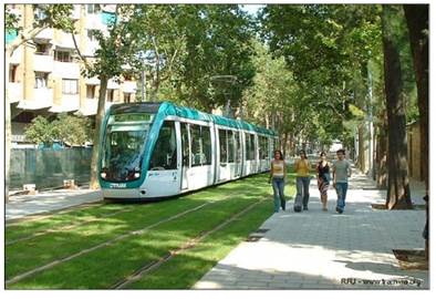
If Cincinnati isn't careful, its in-progress streetcar system might face a similar fate. Whether or not to finish that project was at the heart of the city's recent mayoral election. Stop-construction candidate John Cranley emerged victorious, and earlier this month the city council put the 3.6-mile project on indefinite pause despite about a half-mile of track already laid.

It can't stay on pause much longer. The Federal Transit Administration, which issued Cincinnati roughly $45 million in funding for the project, has asked for a decision on the project by the end of Thursday.

The big issue for Cranley and the city council is whether local taxpayers should be on the hook for potential operating costs. The new mayor has said he's willing to let construction continue if private donors come up with enough cash to pay for the first 30 years of running the system — a figure that's reportedly around $80 million. The auditing firm KPMG is expected to release results of a cost analysis sometime today.

Operating costs should indeed be a concern for Cincinnati, especially since reports suggest that streetcar fares will only cover a quarter of those costs. That leaves a pretty large gap, but not an impossible one. If the streetcar's potential for economic development is as large as supporters believe, a local value capture program — through which the city recovers costs from property owners who benefit from the system — should be sufficient to pay for operations. (That said, a streetcar's precise economic value is often quite tough to determine.)

Proponents of the project point to the fact that the streetcar has already survived two local referendums aimed at destroying it, and that stopping construction now will itself be a massive waste of money. In an editorial last month, the Cincinnati Enquirer called for the project to be finished, estimating that the city will end up spending $53 million in the best-case scenario and $80 million in the worst — with nothing to show for it. The city has seen this movie before:

This is wasteful and irresponsible, especially with the ghost of the canceled Cincinnati subway still haunting us.

That's not entirely figurative word play. The ghost of the subway does, in a sense, haunt Cincinnati — to the tune of millions that must be spent every now and then to maintain the unused tunnels that run below a major road. Call it an anti-operating cost. Those must be calculated, too.
 
Streetcars, being often lighter weight and narrower, often end up being perfect as greenway cars too.

What if, instead of tunneling under Storrow, you simply took a little bit of asphalt (anywhere from .5 to 1.5 lanes), and turned it into track-in-grass, as seen in these many pictures:
https://www.flickr.com/groups/1641257@N23/, such as:
streetcar%20and%20grass.jpg


A commitment to permanently maintain (irrigate and mow) a grassway has got to be the cheapest of all possible right-of-way acquisition processes.

A partly-grassed Storrow (or partly-railed grassy bits) could be the backbone of two awesome circulator routes:

1) Bowdin - Charles MGH - Storrow - Kenmore - Yawkey
2) North Station - Charles MGH - Storrow - Smootway ;-) - MIT@Mass Ave - (Mem Drive) - JFK School
 
Last edited:
You'd need more than 1.5 lanes if you are going to do two tracks with people boarding from both sides. especially if you are on the esplanade and going by the lagoon and under the mass ave bridge.
 
You'd need more than 1.5 lanes if you are going to do two tracks with people boarding from both sides. especially if you are on the esplanade and going by the lagoon and under the mass ave bridge.
This is not a significant objection since it only applies at stations (and I propose going over the Mass Ave bridge (to MIT) or having flexible options going under/through it to get to Kenmore.) And check out the Flickr thread I linked to (some of the meter-gauge trams are, well, about a meter wide).

Obviously, the ROW widens at station stops, but in grassy reservation these could just as easily be a small center platform, or gently offset so that the ROW was never more than 2 tracks and 1 platform wide.

And given the short length of streetcars, the station areas are not very long.
 
Green line trains can't go down storrow, can't you read the signs? Cars only.

In all seriousness tho, that picture is beautiful, I'd love to see something like that here.
 
Green line trains can't go down storrow, can't you read the signs? Cars only.

In all seriousness tho, that picture is beautiful, I'd love to see something like that here.

And note that world-standard streetcars are (often) smaller than our Green Line--narrower track gauge (often 1 meter instead of the GL's 1.435 meter) and narrower loading gauge (width of car itself)
 
Greenway wouldn't work with winter here. Trolleys do get fitted with snowplow blades here to clear the tracks after a fresh dumping of snow. That's going to rip the shit out of the turf. The rock ballast is also the reservation's drainage mechanism and helps with melting because it retains heat better than the surrounding ground, so it serves a very functional purpose especially in this climate.

I agree, though...that's gorgeous. I wish more warm cities in the U.S. currently leading the LRT building boom did that in reservation applications instead of just pouring a hard concrete base. Concrete accentuates the urban heat island effect, while turf reduces it a smidge. And carries a placebo effect for pedestrians walking on those streets that makes the heat island seem less oppressive than it is.
 
Greenway wouldn't work with winter here. Trolleys do get fitted with snowplow blades here to clear the tracks after a fresh dumping of snow. That's going to rip the shit out of the turf. The rock ballast is also the reservation's drainage mechanism and helps with melting because it retains heat better than the surrounding ground, so it serves a very functional purpose especially in this climate.

I'll bet you $10 that laying new live sod in "panel inserts" every spring and pulling them up every fall--like it was some kind of NFL stadium turf--and doing so in perpetuity will *still* be cheaper than any other proposal on the table (tunnels, surface acquisition, utility ROW, street running...)

Or Astroturf it.
 
It's also not like our reservations are particularly unattractive. The C is downright pretty with the rows of mature trees framing it, and they did a really nice streetscaping job along the E reservation with fresh plantings. B's not quite as hideous as it used to be after the BU lane-drop, and if they ever get the Bridge-Packards reconstruction started that should follow suit. Packards-Warren has a lot of Beacon-like potential with the proposed radical reconfiguration of the road with wide center reservation.
 
How serious/far along is that Comm Ave reconfiguration? I'm kind of surprised people aren't flipping out given that it's an historic Olmstead design.
 
How serious/far along is that Comm Ave reconfiguration? I'm kind of surprised people aren't flipping out given that it's an historic Olmstead design.

Who knows? I think something is starting to creak along in the planning a little bit after years of delays, but it's not exactly well-publicized.

Olmstead only designed the Newton portion. He was the originator of the idea of building Beacon and Comm as wide boulevards out there and widening Brighton Ave. into similar, but he didn't get the contract for its final design. Kenmore-west it's always been the same old old trolley reservation since the A line became Boston's first electric streetcar in 1892, and I think it might've been a horsecar line for some time before that. The Packards-Warren abomination has always been in that general 3-carriageway setup, though originally the express lanes were undivided, narrower, and had a second pair of sidewalks lining them. The hills were likewise same setup because it was the only way to access the high-elevation side streets. The trolley reservation out there didn't come until 1909, which is why it's awkwardly placed to the side out to Warren and why the reservation varies so much in width up to Chestnut Hill. That was the first major reconstruction of the road. Before then there was a streetcar gap between Packards Corner and Chestnut Hill Ave., with just the A, C, and the Newton-Reservoir lines having service. At some point somebody took out the second pair of sidewalks, widened the thru portion of the road, and tried to turn it into a proto-expressway.


Interestingly, the whole road up the hill was seen as a colossal urban planning failure for decades. Only like a half-dozen total buildings as late as 1910. Beacon St. in Brookline stole all the thunder and cleaned Comm Ave.'s clock at attracting development. Nobody wanted to build there. Filling the trolley gap between Packards-Chestnut Hill was the final bailout plan for the corridor that finally got the residential infill moving.

And of course in the auto era the entire drag up to Packards and Harvard Ave. was just ugly-ass car dealerships. The changeover is all post-1965 and BU-driven.
 

Back
Top