The Tobin Bridge Thread

commuter guy

Active Member
Joined
Feb 1, 2007
Messages
859
Reaction score
80
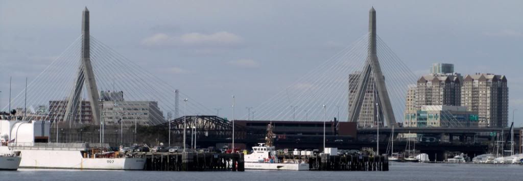
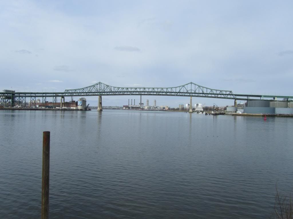
I'm probably in the minority, but I like the look of the Tobin more than the Zakim Bunker Hill bridge.
 
Re: Photo of the Day, Boston Style: Part IV (2011)

I don't think you're (we're) in a minority at all. And if we are, everyone can suck ittttt.

pluto


Does anyone know how long the Tobin is expected to last? I have no idea what the maintenance record is for it, but I'd bet it's very poor with tons of deferred maintenance. I'm intrigued to think of what it would be replaced with (or how), but I don't ever want to see it happen.
 
Re: Photo of the Day, Boston Style: Part IV (2011)

I'd like to see the Tobin replaced some day, with a bridge that can also accommodate bicycles and pedestrians. Right now the bridge is a huge uncrossable barrier for anyone not in a car (or the #111 bus).
 
Re: Photo of the Day, Boston Style: Part IV (2011)

I'd like to see the Tobin replaced some day, with a bridge that can also accommodate bicycles and pedestrians. Right now the bridge is a huge uncrossable barrier for anyone not in a car (or the #111 bus).

At the very least an HOV lane for buses. It is too important of a crossing not to have it multi modal. The old swing bridge did the job until a storm blew it out (so the story goes) and the highway men jumped on it.
 
Re: Photo of the Day, Boston Style: Part IV (2011)

If they ever did build a new bridge there isn't much room next to the Tobin without demolishing quite a few homes. The best option would probably be to upgrade the parkway to interstate standards from the Route 1 interchange to a new interchange with Route 1a, then expanding Route 1a down to the Airport to full standards. Then you can shut down all of Route 1 from the bridge to the Revere Beach Parkway and build the new bridge/reconstruct the elevated highway. That way you have enough capacity on the bypass and the new bridge can lose a lane for transit/ped/biking.
 
Re: Photo of the Day, Boston Style: Part IV (2011)

Build a tunnel to replace the Tobin and all of a sudden a lot of real estate opens up in Charlestown and Chelsea for development. Land which could be sold to pay for the tunnel.
 
Re: Photo of the Day, Boston Style: Part IV (2011)

A tunnel could be built along the east side of the existing bridge as an alternative to a new bridge. But if a new bridge is built, I would move it to the more vacant side of Chelsea as shown on this map.

http://maps.google.com/maps/ms?ie=U...42.387441,-71.048176&spn=0.033282,0.0842&z=14

It should be double deck, four lanes each way, 3 lanes general traffic plus a dedicated bus lane each direction, plus a wide pedestrian/bicycle lane alongside the lower deck. The bus lanes would exit/enter Chelsea street in Charlestown on short slip ramps where the Tobin stacked roadways are each at the same level as the street. The tunnels under City Square won't accomodate a bus lane.
 
Re: Photo of the Day, Boston Style: Part IV (2011)

Idea: Elevated over Newburyport/Rockport Line until the old ROW to Eastie splits off and go over that. Bridge parallel to Chelsea St Bridge and then just tie in to the Pike extension/Rt 1A. Only problem is the Ted just doesn't have the capacity, I don't think, and the Sumner/Callahan would be useless.
 
I'm not in favor of upgrading anything to Interstate standards. Those standards are designed for the wide open spaces of the western states. We do just fine with our "substandard" cramped highways that minimize land-takings.
 
Re: Photo of the Day, Boston Style: Part IV (2011)

A tunnel could be built along the east side of the existing bridge as an alternative to a new bridge. But if a new bridge is built, I would move it to the more vacant side of Chelsea as shown on this map.

http://maps.google.com/maps/ms?ie=U...42.387441,-71.048176&spn=0.033282,0.0842&z=14

It should be double deck, four lanes each way, 3 lanes general traffic plus a dedicated bus lane each direction, plus a wide pedestrian/bicycle lane alongside the lower deck. The bus lanes would exit/enter Chelsea street in Charlestown on short slip ramps where the Tobin stacked roadways are each at the same level as the street. The tunnels under City Square won't accomodate a bus lane.

Better yet, why not upgrade Route 16 and 99 and utilize that already industrialized corridor. Taking down that section of Route 1 would revitalize Chelsea and allow opportunities for developers. It might also advance part of the Urban Ring project by phasing it together as one project.

The Tobin Bridge replaced one of the strongest connections between Boston and the North Shore. Broadway Avenue used to be known as the Salem Turnpike, and the former Broadway Bridge crossing over the Mystic River was a catalyst for downtown life and development.

I say relocate Route 1 down Route 99, and construct a light passenger car tunnel to the beginning of Broadway Ave. Either that or construct a new bridge that allows smaller vessels to travel under. Why do large barges have to come down the river anyway? All large barges should unload at the tip of Charlestown or East Boston.

As for the design of the Tobin, I love the steel truss structure spanning the river, but hate the concrete piers. There has to be a more elegant way for the bridge to be supported. For instance, most of the Manhattan bridges.
 
LNG tankers go under the Tobin Bridge to reach the terminal in Everett.
 
I like Charlie_mta's idea for rerouting route 1. Dig a tunnel following that route, then tear down the Tobin and replace it with low bridge connecting Broadway and Chelsea Street that can be opened for ships. Suddenly you don't have to have a death wish to walk or bike to Boston from Chelsea.
 
Here's a rough pitch for when the Tobin must finally come down one day (a sad day it will surely be...)

https://www.google.com/maps/ms?msid...&ll=42.391262,-71.02541&spn=0.085831,0.181789

Of note is that the 107/Broadway Bridge would be like a normal street (a la Meridian St or Chelsea St bridges) but with bus lanes. I think it should have four "slide away" leafs (Summer St Bridge on the Fort Point, which only has two however, this would slide away in both directions). This is to maximize horizontal clearance and provide unlimited vertical clearance.

The Levritt Loop Ramps would originate/terminate at Rutherford Ave.


I'm thinking of ways to consolidate roads where 60/16/1A meet.

I think the challenge is the high school and residential properties-- that one neighborhood that has 16 on one side and 1 on the other.... Route 1 is barely squeezed through there as it is.

Also-- how would motorists get from 1N to 16W? Two left turns isn't ideal.
 
I think the challenge is the high school and residential properties-- that one neighborhood that has 16 on one side and 1 on the other.... Route 1 is barely squeezed through there as it is.

Also-- how would motorists get from 1N to 16W? Two left turns isn't ideal.

I'm not sure I understand what you mean?

Route 1 would be removed entirely from the Chelsea Curve to the Levritt Ramps. MA-16 would briefly take place of Rt 1 near the high school due to possibly better/less destructive alignment.

And 1N to 16W is easy. You'd stay in the right lane where you cross over Broadway near Revere Center. You'd go down a ramp, under the highway, and you're on 16W.
 
I had always thought rerouting it via 99 would be the way to go, until I actually realized how much work it would take to make it a limited access highway. There are sooo many abutters.

I would therefore reroute rt 1 over the tracks through existing industrialized property. Sell the now clear land to make up some of the costs and heal the scar across Charlestown and Chelsea. Almost all of the path is already owned by the government.

I would also advocate for building a draw bridge to replace the Tobin and reconnect Broadway to Chelsea St.

A bike and pedestrian bridge able to carry emergency vehicles (and busses maybe) could/should also be built regardless connecting Decatur St in Eastie to 16th St In Charlestown.

EDIT: Like So:http://goo.gl/maps/zugku
 
Last edited:
Another good one. But I think 93 is too taxed. Whereas the most recent Pike extension is empty.
 

Back
Top