Tobin Bridge Relocation/Replacement

The tunnel that leads to Tobin Bridge is already very close to North Station. Build a tunnel that takes a turn and go under the Charles, build a flying junction at GL North Station (which will hopefully be easier than otherwise would, given that the two GL tracks are on different levels there), and you're there. Northside Green Line has much more spare capacity than southside today (and remains so under most GL Reconfiguration proposals), so you can easily extend, say, the C trains to take on this branch to Chelsea.

I wonder how feasible that would be. The GL trackage is under the Garden/Hub on Causeway and I don't think there's a ton of room to the east before you hit the Orange Line. Might be possible, but you'd have to go awful deep under the Garden or blow its parking garage to smithereens to get the southbound leg of a flying junction on-alignment.

If the GL flyover at North Station is infeasible, another potential idea is to use the old center tracks at Haymarket (with a crossover north of the present-day station to get to the center tracks), though I'm not sure how much of those structures remain intact today. For a cheap build, you can either use the portal to get to street level, and follow the route of the 111 bus today. For a more expensive build, use the center tracks to separate from the main GL tracks, but stay underground with separate North Station platforms somewhere.

Old Haymarket is a mess. A good amount of the old station is still there, but they carved up the platforms pretty good when they relocated the Green Line incline out of the portal at some point in the 90s. The portal is completely gone, with One Canal built on top of the incline. The current westbound GL track is basically at the western edge of where the portal was, with the eastbound some distance apart. There's probably two-tracks-worth of space in the middle, but no way to get there except from below, and quite possibly not enough space for an incline because part of the center track space was taken up by the accesses to New Haymarket's GL platform.
 
Documents for the RFP can be found here, and the one with the more interesting details is hopefully attached.

One thing of note is that the scope is everything from I-93 to the border of Revere, so fixing the Chelsea Curves is within the scope of this planning
 

Attachments

  • 2023 Tobin Bridge Scope V9.21.23.pdf
    344.8 KB · Views: 278
Quick comment on the Orange Line split "halving capacity". Nothing I have ever seen in proposed train headways for the current Orange Line ever comes close to using the new capacity of the downtown Main Line tunnel once signal modernization is completed. So what you really need to keep both branches at reasonable service levels is more cars (and operators).
I was wondering about this. What is the expected capacity of the orange line?

Also, while I basically agree with your point here, I'll push back a little. There's a lot of new development being built or planned around Community College, Sullivan, and Assembly. Additionally, Sullivan is already a transit hub for busses, and any proposed expansions (like new Silver Lines or Urban Ring) tend to go through there. Even if there's no current plans to use OL near its capacity, it could be a longer term problem to permanently cut capacity in half at Sullivan.
I don't know where the T has published the exact details, but both the Red Line and the Orange Line are getting the same signal upgrades (and fundamentally equivalent CRRC cars), so both lines should have the potential for the same headway in the future.

Red with its 250+ car fleet will be running about 3 minute headways at peak on the non-branched portion.

Orange with its 150+ car fleet will only be running about 5 minute headways at peak. That suggests that Orange has additional capacity to spare (for a branch), if it had more cars.
 
I was wondering about this. What is the expected capacity of the orange line?

Also, while I basically agree with your point here, I'll push back a little. There's a lot of new development being built or planned around Community College, Sullivan, and Assembly. Additionally, Sullivan is already a transit hub for busses, and any proposed expansions (like new Silver Lines or Urban Ring) tend to go through there. Even if there's no current plans to use OL near its capacity, it could be a longer term problem to permanently cut capacity in half at Sullivan.

I've often thought that Sullivan should be an edge station with connections to the commuter rail network that RM Transit speaks about often.
 
How about routing route 1 through the current route 16 corridor connecting it to 1A and eventually the Mass Pike. I'd suggest eminent domaining by the Hampton inn and solar farm to create a direct route from 16 (new route 1) to 1A south, and from 1A north to 16.

1A could be upgraded to 3 lanes each way through that corridor, probably with some eminent takings, and removing the 2 lights prior to getting to the elevated east Boston portion. 2 lanes would work, but it might turn into a bottleneck.

Then you could tare down the elevated portion of route 1 through Chelsea and Charlestown and build a less expensive bridge to replace the Tobin, carrying a good bit less traffic than the current bridge.
I don't think the width of the bridge really impacts the cost that much. The big challenge is getting it high enough to clear the ships.
 
I don't think the width of the bridge really impacts the cost that much. The big challenge is getting it high enough to clear the ships.
Redevelopment of the power station and oil tanks will reduce the need for high vessel traffic. The auto port is more difficult, though that could also be redeveloped at some point. You may also be able to reconfigure the bridge to still allow high vessels to dock to the right of it.
 
Isn't the entire auto port on the south side of the Mystic completely vulnerable to severe flooding by 2050? IIRC the whole entire thing is only 6 - 9 feet above current sea levels, meaning any amount of sea level rise, or a direct hurricane strike, will cause the area to flood, and the floodplain extends out covering all of Charlestown's deeply affordable housing stock, and much of the Navy Yard, all of which carry this flood risk.
 
Isn't the entire auto port on the south side of the Mystic completely vulnerable to severe flooding by 2050? IIRC the whole entire thing is only 6 - 9 feet above current sea levels, meaning any amount of sea level rise, or a direct hurricane strike, will cause the area to flood, and the floodplain extends out covering all of Charlestown's deeply affordable housing stock, and much of the Navy Yard, all of which carry this flood risk.
At some point we are going to be forced to protect rather than abandon all this coastal infrastructure. I don't see people seriously suggesting we abandon Logan Airport, for example.
 
At some point we are going to be forced to protect rather than abandon all this coastal infrastructure. I don't see people seriously suggesting we abandon Logan Airport, for example.
It certainly seems like that will end up looking like some kind of barrier across the harbor, and I suspect that will for the most part end Boston's role as a major port.
 
It certainly seems like that will end up looking like some kind of barrier across the harbor, and I suspect that will for the most part end Boston's role as a major port.
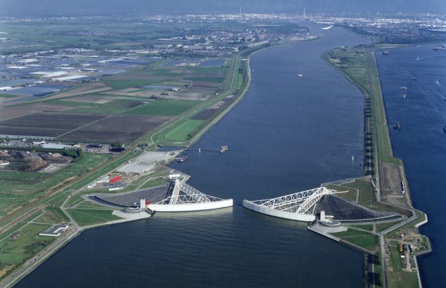
Not really. Rotterdam has a major harbor barrier and is still one of the largest ports in Europe.

Check out the Maeslantkering.
 
It certainly seems like that will end up looking like some kind of barrier across the harbor, and I suspect that will for the most part end Boston's role as a major port.
Boston hasn't been a major port in decades, only at 44th in total tonnage. As a comparison, Houston handles 20 times as much as Boston. But a storm surge barrier wouldn't diminish the level of shipping we currently have, as it would be open most of the time, only closing during potential flood events.
 

Should this be moved to the infrastructure section?
 

Back
Top