You are using an out of date browser. It may not display this or other websites correctly.
You should upgrade or use an alternative browser.
You should upgrade or use an alternative browser.
Underground station layouts
- Thread starter The EGE
- Start date
The EGE
Senior Member
- Joined
- Jun 29, 2013
- Messages
- 1,905
- Reaction score
- 5,270
I can only assume that the ramps are ADA compliant - while the station was built prior to the ADA, the MAAB had similar regulations by the time Harvard opened.
I can't speak for the dimensional feasibility of any of your questions; I haven't been there myself.
I can't speak for the dimensional feasibility of any of your questions; I haven't been there myself.
EGE, can you show the part just below where the tunnel crosses under the Pike?Some more of what once was, before I go back to what is. The abandoned (lighter color) bits shown here are shown up to the surface; although at least something exists of them, not all that is shown is still extant. From L-R:
View attachment 4946
- Public Garden Portal (used 1897-1914). Most likely, nothing exists except for the bellmouth under Charles Street.
- Boylston Street Portal (1914-1941). Now occupied by a maintenance siding and a pump room.
- Provision for the never-built extension to Post Office Square
- Southern branch of the Tremont Street Subway to the Pleasant Street Incline (1897-1962). Intact up to just south of the flying junction; this hatch is the southern end of the tunnel proper, where it met the open incline. This track configuration is as-built; it may have been slightly different when streetcar service resumed after the Main Line El's 1901-08 use of the subway.
- The incline to the Washington Street Elevated (1908-1987). From the south end of the outbound platform at Chinatown, you can still see about 100 feet of the tunnel.
With @The EGE's permission, I have collated his station diagrams into a list on my website, listed on my Useful Things page. (Hopefully easier to navigate than the forum's search software!) Laid out all in a single list, you can see how much of the network he's done -- really impressive work!
stick n move
Superstar
- Joined
- Oct 14, 2009
- Messages
- 13,614
- Reaction score
- 25,077
I was browsing the documentation for 50 sudbury and came across this pretty highly detailed model of haymarket station and figured this would be a good place to put it.

https://bpda.app.box.com/s/id93qld1yjkdkbvhee0u5jft9dbbb14r
https://bpda.app.box.com/s/id93qld1yjkdkbvhee0u5jft9dbbb14r
- Joined
- May 25, 2006
- Messages
- 7,068
- Reaction score
- 2,004
Hell yes. I remember this was a bitch to try and draw for my track map. I think I just said fuck it and approximated it.
ceo
Active Member
- Joined
- May 4, 2009
- Messages
- 669
- Reaction score
- 921
I'm having trouble making sense of this. Is this the Green Line station or is it the mess of former track alignments between Haymarket and North Station? If you click through to the original, it has a higher-resolution version.
RandomWalk
Senior Member
- Joined
- Feb 2, 2014
- Messages
- 3,837
- Reaction score
- 6,976
It’s mostly the Green Line track between Haymarket and North Station. The platform is just off the left side of the image. The Orange Line tracks are at the bottom. It’s centered on the old Haymarket Green Line, before the 1971 relocation.
TheRatmeister
Senior Member
- Joined
- Sep 23, 2023
- Messages
- 1,580
- Reaction score
- 3,203
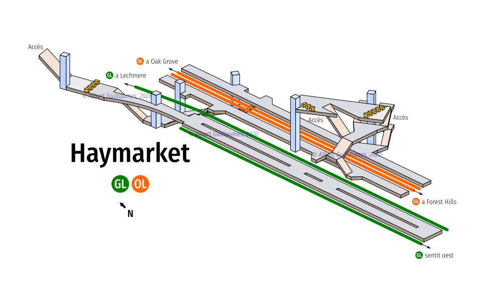
It took me way too long to figure out, but its the north side of the GL platforms and the mezzanine area. Here's the diagram from everyone's favorite station-diagramming Spaniard where you can see what I'm referring to.I'm having trouble making sense of this. Is this the Green Line station or is it the mess of former track alignments between Haymarket and North Station? If you click through to the original, it has a higher-resolution version.
Brattle Loop
Senior Member
- Joined
- Apr 28, 2020
- Messages
- 1,176
- Reaction score
- 2,105
The PDF linked by @stick n move had an excellent diagram of that area of old Haymarket, buried under a bunch of layers. I've rotated it to approximately match the orientation of the 3D version.

stick n move
Superstar
- Joined
- Oct 14, 2009
- Messages
- 13,614
- Reaction score
- 25,077
Idk how you did that but thats awesome. I thought about posting the image where that came from but it was just so cluttered I figured it wasnt worth it. I guess it was.The PDF linked by @stick n move had an excellent diagram of that area of old Haymarket, buried under a bunch of layers. I've rotated it to approximately match the orientation of the 3D version.
View attachment 48550
Brattle Loop
Senior Member
- Joined
- Apr 28, 2020
- Messages
- 1,176
- Reaction score
- 2,105
That red diagram was an embedded image, and all the stuff on top of it was separate layers, which made it a lot easier than I thought it would be to pull it out in Illustrator. No idea why that was done like that, but I'm glad it was.Idk how you did that but thats awesome. I thought about posting the image where that came from but it was just so cluttered I figured it wasnt worth it. I guess it was.
So, I ve been trying to place exactly where the southernmost end of the OL station is in relation to the surface.The PDF linked by @stick n move had an excellent diagram of that area of old Haymarket, buried under a bunch of layers. I've rotated it to approximately match the orientation of the 3D version.
View attachment 48550
Aprehensive_Words
Active Member
- Joined
- Oct 18, 2022
- Messages
- 278
- Reaction score
- 543
I wonder if this layout means we can have at least a shred of hope that the ceiling of the Haymarket GL fare gate area + connector to the platforms will get re-waterproofed when HYM is able to get around to building its lab building?
BeyondRevenue
Active Member
- Joined
- Mar 13, 2020
- Messages
- 553
- Reaction score
- 1,157
The EGE
Senior Member
- Joined
- Jun 29, 2013
- Messages
- 1,905
- Reaction score
- 5,270
Unfortunately, it's not possible, as we've discussed before. There's only about 2 feet between the surface of Congress Street (ex-Washington Street) and the top of the Green Line tunnel. If you want a southern entrance to the Green Line, you either go under the tracks or put a new headhouse on the southwest side of Congress.

Ashnot
New member
- Joined
- Dec 16, 2024
- Messages
- 8
- Reaction score
- 28
I was at Haymarket a couple of months ago, there's an emergency exit on the northbound platform near the southern end of the platform. The surface doors are in the same building as the Orange Line lobby. You can see the surface doors on Google Street view, it's a set of red unmarked double doors. I'm not sure how the stairs are positioned, but it is definitely there.