Whats left to build on?

Now that Northern Avenue is realigned and a few more buildings have filled in the area, I was looking at the parcels with no definite proposals and was thinking that parcel G would be a great place for a library. It is a quick walk from south station/downtown, chinatown, anywhere in south boston, and its right next to the new park. The L parcels are going to be all residential, theres tons of offices going up, and all of these people plus part of downtown would benefit from this. The innovation district is criticized for building the court house on the waterfront, generic glass boxes, and not having the critical pieces that make a neighborhood livable. Im not saying thats all true but I think some of these parcels close to the water should be used for other things than office buildings.

I think this parcel would be great because its next to a park, close to the waterfront, near pier 4 which will be a huge tourist destination, and easy to get to from both the seaport and downtown. Also it would help to not box the park in, would be only a few floors tall, thus helping the views from offices have a sightline to the harbor. A modern library would be nice, but I think the immediate area is so new that an art deco building would do a lot more to give some character to the neighborhood. Let me know what you guys think. It would be located on the main road through the seaport, close to tons of shopping, close to the harborwalk, right behind the ICA and also right next to pier 4. I think this would be a great addition to the area. It most likely would never happen because they would rather sell the parcel to a developer, but IMO this is a very good spot.

I think the best case scenario would be to not build the tower next to goodwin proctor- keep it as a parking garage, and then build this next to the park so there is a great sight line to the harbor (by not having goodwin proctor tower 2) and then build a library that is only a couple stories tall so the park does not get boxed in by towers. Making it a very nice limestone building would also give some depth to the architecture in the area. This would be another great reason to be in this immediate area having a library, park, museum, harborwalk, lots of retail, and pier 4 with its park and steps to the water.

Seaport-Square-B1-651x516.jpg
 
Last edited:
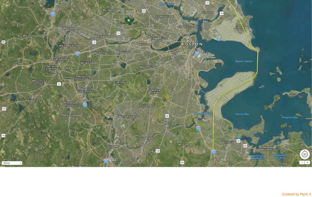
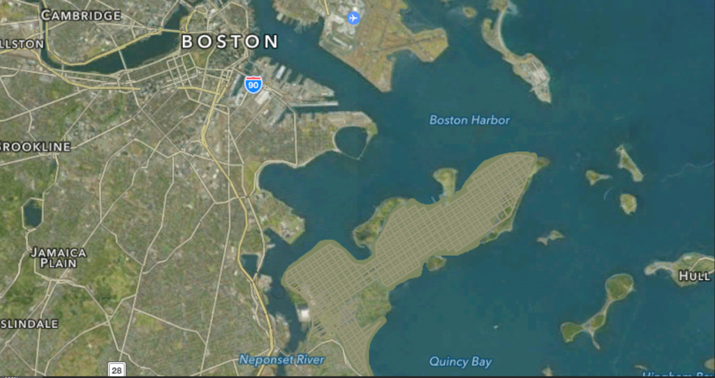
Move Logan To Hanscom or somewhere on the new lower peninsula. Direct transit access, along with easy access from 95 if built at Hanscom. Fill in the chain islands out in the harbor. Build a new gateway bridge to Boston harbor. Effectively double Boston's size. Build a ton of brownstones/terra cotta/limestone on the land. Add a shit ton of affordable housing. Downtown views from the now huge Eastie. Great side shots of the city from the lower peninsula. Create an 395 loop around the city. Add transit. FAA heigh restrictions removed. Boston builds supertalls, fixes the housing crisis, gains a new neighborhood, triples the size of another. Problem solved.

 
The much more reasonable reclamation project. The islands could be left as parks and even some of them could have much of the shoreline left with mostly in between filled in.

 
This version could mainly leave the islands untouched other than land connections. Mostly ocean fill, except for long island but the old architecture could be integrated. Basically fill in the ocean in between the islands. There could be a plan to use dredged silt from the harbor dredging which is supposed to happen, also there could be artificial reefs and other mitigation projects that would cover the lost sea floor and even improved upon with the right plan. Oyster farms etc...

 
These all sound like cool new ideas, but Boston still has plenty of land to build on. Everytime I see the wasteland that is Sullivan Square, the empty parcels along the SE Expressway or the sparsely populated parts of Hyde Park, Mattapan and Rozzie, I see that there is PLENTY of space within the city limits. That doesn't include the places outside the city but have T train connections. The leaders just have to be creative, extend public transit where necessary and build!
 
Your proposals definitely create complications for transit. Both new-Eastie and new-Southie are dense enough to probably need a rapid transit line, but you're looking at a very expensive cross-harbor tunnel for either to reach downtown. The Red Line cannot support a third southern branch, and the Blue Line will be very near capacity once extended to Lynn (a vastly higher priority than filling in Crystal Cove).
 
Not sure if this has been posted recently, but this shows a previous future growth through 2030 map from MAPC:


Downloadable PDF on the linked to page gets a bit better resolution.

It is a bit dated at this point, but still useful to mapping out all the targeted growth areas in Metropolitan Boston.
 
Your proposals definitely create complications for transit. Both new-Eastie and new-Southie are dense enough to probably need a rapid transit line, but you're looking at a very expensive cross-harbor tunnel for either to reach downtown. The Red Line cannot support a third southern branch, and the Blue Line will be very near capacity once extended to Lynn (a vastly higher priority than filling in Crystal Cove).

Its obviously not gonna happen but the urban ring could cross the neoponsit river and follow 395.
 
That does nothing about the fundamental issue, though. You're making everyone in your new land transfer to already crowded radial subway lines.
 
There is no way you're filling in the Belle Isle Marsh or Squantum Marsh. No. fucking. way. Earth is not Coruscant, yet, so no one is going to let that slide.

That said, it'd be cool to see the space between Long, Moon, Spectacle, and Thompson Islands filled in as there's no wetlands there. There is a risk that there may be clam/muscle beds in there, though. If so, that is doomed as well.

As pointed out, we have so much else to do right now. The core needs more focus before we stray off like this.
 
There is no way that Bedford and Lexington would allow Logan to move into their backyard, too much money and power in those towns for that option to be reasonable.
 
MassDOT and Massport are already looking at their options for scaling up airports across the Commonwealth in anticipation of rising sea levels that put Logan in jeopardy. Hanscomm being turned into one of Boston's new primary international airports isn't too far off the mark.

I'll echo what others have said here, basically that we have plenty of land near transit on high ground without needing harbour infill, which would almost definitely not pass EPA approval.

MAPC and Boston MPO are really trying to get 'Gateway' cities to focus development in the pattern tangent brings up, but as we're seeing, many towns are still obstructionist to more dense development where the transport network could otherwise handle it while (re)building active 'main streets' near transit hubs.
 
MassDOT and Massport are already looking at their options for scaling up airports across the Commonwealth in anticipation of rising sea levels that put Logan in jeopardy.

I'm deeply skeptical of this statement. Source?
 
I'm deeply skeptical of this statement. Source?

Having trouble finding the specific report/capital plan, but resilience in the face of rising sea levels is something that pervades a lot of MassDOT long-range planning these days and is in Massport's best interest to anticipate. I think it may have been Rich Davey when he was at MassDOT (also Massport board member/chair) who mentioned the need to consider other regional airports in the event of catastrophic flooding at Logan and needing to make more robust those regional airports as a long-range plan.

If/when I find it, I'll post in thread or update this post. Massport's site is down - it's possible the report I read was an environmental resiliency report they published and not MassDOT.
 
Having trouble finding the specific report/capital plan, but resilience in the face of rising sea levels is something that pervades a lot of MassDOT long-range planning these days and is in Massport's best interest to anticipate.

Sure, but if we are talking about 3 to 6 feet of sea level rise, then Logan is better off just raising up the runways and sea walls about that much rather than moving. Yes 10 to 20 feet of sea level rise and the airport likely has to move along with a sizable portion of the waterfront development. But 3 to 6 feet is pretty much the upper end of the likely sea level rise in the next 100 years. Anything else is really beyond a worthwhile planning horizon.

So the thing that should be on the table is what it would take to raise much of Logan up to about 6 feet in the next 60 to 80 years.
 
Guys - build a sea wall and you protect the whole city, airport included, probably for a comparable amount of money and maybe even with less dirt.

Right?
 
I'll echo what others have said here, basically that we have plenty of land near transit on high ground without needing harbour infill, which would almost definitely not pass EPA approval.


What's stopping us from filling in much of the harbor for needed land, then killing two birds with one stone by building a massive beach head or breakwater well in front of what today is the waterfront?

We could eventually leave only a small slit into the bay in front of Quincy.

and fill the rest of the whole smash.

These guys:

latest


Not to mention MassPort still has plans to grow the terminals.
 
Sure, but if we are talking about 3 to 6 feet of sea level rise, then Logan is better off just raising up the runways and sea walls about that much rather than moving. Yes 10 to 20 feet of sea level rise and the airport likely has to move along with a sizable portion of the waterfront development. But 3 to 6 feet is pretty much the upper end of the likely sea level rise in the next 100 years. Anything else is really beyond a worthwhile planning horizon.

So the thing that should be on the table is what it would take to raise much of Logan up to about 6 feet in the next 60 to 80 years.

The way MassDOT defines resiliency isn't just taking into account average sea level rise from climate change. It's also about anticipating the effect of increasingly strong and harsh storms and the extreme storm surge that comes with it.

They know full well that we'd have been in just as shitty a situation as New York if Superstorm Sandy had decided to make landfall on us, which I believe was the original forecast. It's projected that this will be an increasing occurrence and is a good reason to build system-wide redundancy/increased capacity for resilience. This is what they're trying to plan for - this on top of economic growth and viability that they don't want constrained by putting all our eggs in a single large airport in Eastern MA.
 

Back
Top