Hook Wharf | 400 Atlantic Ave | Downtown

I really wish that all parties involved with this, including the city, won't drag their feet on this. This needs to move. That parcel is key to marrying downtown, the Greenway, and the SBW, and it's so barren and blighted right now.
 
Barren and blighted?!? What about those two lovely picnic tables that are on the damaged part of the pier for some reason?
 
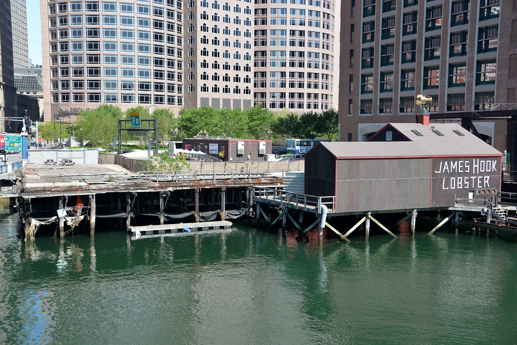
17461461988_e1af685cdf_b.jpg

The worst part of this photo is the highway signs.

(or maybe the palladian (shh) windows)
 
Last edited:
Maybe 305' is indeed too tall (I don't think so, but could be persuaded), but it seems to me that the three different "In Compliance" heights are all shorter than what a building right on downtown in a major city deserves. At any of those heights, this site would be far, far shorter than some of its neighbors, and just shorter than a few others: International Place (600'), Atlantic Wharf (395'), the Intercontinental (237'), Independence Wharf (174' - equal to Hook's Greenway Guidelines height), or even Rowes Wharf (182'). That makes no sense.
 
I got no problem with this. Why do people always freak out over height in the middle of downtown?! It's not like this is such an amazing section of Greenway where this will have a detrimental impact on the park. Hell, it will bring more people to the park! Hell, those parks should be skyscrapers anyway.
 
The bostoninno article overlooked a point in the draft BRA planning document, in that Hook doesn't own the entirety of the site on which this proposed building would sit. A significant portion of the site is owned by the Commonwealth, and it is the Commonwealth, not the BRA or Mayor Walsh, that will decide whether Hook can build on tidal lands owned by the Commonwealth. There may also be an issue with respect to Section 404 permits, which is Federal permit governing the navigable waters of the United States.
 
The fact that there are three disparate height "recommendations" (55', 155', 175') leads me to believe that people are just pulling figures out of there asses. If there were some objective way of determining the "proper" height for the site, there would be far less variation. 305' is as good as (and as arbitrary as) any other height. It comes down to preference and vision, and ultimately the persuasiveness of the individuals/groups in question when the plans are being made.
 
This one pisses me off. The sight looks horrible, and it really is at the butt end of the touristy part of the Greenway. Let the developer build something nice and profitable that will bring more people to the area as well as create a nice transition from downtown into the Seaport. It's stupid to waste any more time here.

I choose letting this one go through much faster than the Harbor Garage proposal.

Agreed. I see plenty of valid concerns with the Harbor Garage proposal but this one? Not so much.

Approve the damn thing and get it built.
 
So looking at the variance picture above why not make Hook (Even Chiorfano) chip in to fix the fort point bridge, as a condition for the variance.
 
I think the building as proposed at 305' is quite elegant in terms of its massing. A blockier 305' tower would be a different story.
 
I think the building as proposed at 305' is quite elegant in terms of its massing. A blockier 305' tower would be a different story.

So you're ^ saying that you dont want the current layout with the picnic tables? LOL

I agree, the 305' tower would look great, but I'd like to see more renderings vs a CAD-type depiction.
 
Great location for something tall as shown by data. And if a residence, then it would have a particular cache!
 
Got a question: is there a reason that the neighbor sites to the Moakley Bridge don't interact with it at all? I'm aware that it is a bridge, with a structure and all and that you wouldn't want to damage its stability, but neither Independence Wharf nor the second render shown have any connections between the bridge and their site. I was crossing the FP Channel yesterday and noticed that the railing for the bridge goes all the way to the intersection despite the fact that Independence Wharf and the Harborwalk could meet up with the bridge farther out.

Now, case in point, look at this render: again, you can see that, despite the fact that it might be convenient to tie the bridge into the development site, the bridge's railing (blue and grey) goes all the way to the intersection, leaving an awkward gap between the pedestrians on the harborwalk/outdoor dining and the pedestrians crossing the bridge. Why is that?
jxu6olL.png
 
Got a question: is there a reason that the neighbor sites to the Moakley Bridge don't interact with it at all? I'm aware that it is a bridge, with a structure and all and that you wouldn't want to damage its stability, but neither Independence Wharf nor the second render shown have any connections between the bridge and their site. I was crossing the FP Channel yesterday and noticed that the railing for the bridge goes all the way to the intersection despite the fact that Independence Wharf and the Harborwalk could meet up with the bridge farther out.

Now, case in point, look at this render: again, you can see that, despite the fact that it might be convenient to tie the bridge into the development site, the bridge's railing (blue and grey) goes all the way to the intersection, leaving an awkward gap between the pedestrians on the harborwalk/outdoor dining and the pedestrians crossing the bridge. Why is that?

Timsox -- there are two factors involved one is history:

  • 1) what was there or even theorized when the Moakley was designed and then built
  • 2) the land versus water and who had the relevant regulatory jurisdictions

#1 has changed but the Fort Point Channel land / water boundary has not --the Moakley Bridge connects "permanent" land in South Boston / Seaport / Innovation with "permanent" land in downtown it doesn't connect to piers or floating docks, etc.
 

Back
Top