You are using an out of date browser. It may not display this or other websites correctly.
You should upgrade or use an alternative browser.
You should upgrade or use an alternative browser.
Hook Wharf | 400 Atlantic Ave | Downtown
- Thread starter stellarfun
- Start date
bigpicture7
Senior Member
- Joined
- May 5, 2016
- Messages
- 4,068
- Reaction score
- 10,551
Apologies for adding to the fantasy discussion: with the render it looks a little like the Chicago River!
it would help if the northern ave. bridge wasn't about to disintegrate (this is an older picture with the bridge in better shape than it actually is). One would have to imagine that restoration, or at a minimum, complete dismantling, of the bridge should take place in conjunction with this project...else its rotting downtown-side structure is practically embedded in the front plaza of the highrise.
Apologies for adding to the fantasy discussion: with the render it looks a little like the Chicago River!
Agree. I had the exact same thought a few hours ago but was too lazy to log the comment

stick n move
Superstar
- Joined
- Oct 14, 2009
- Messages
- 13,482
- Reaction score
- 24,540
They should build this tower and my bridge and call it a day.

odurandina
Senior Member
- Joined
- Dec 1, 2015
- Messages
- 5,328
- Reaction score
- 266
That's fantastic.
stick n move
Superstar
- Joined
- Oct 14, 2009
- Messages
- 13,482
- Reaction score
- 24,540
Sorry to keep dragging out the discussion of the taller tower on this parcel, but theres not much news here so I dont mind a little bit of a side discussion. I think the height looks good here because the towers along the channel are mostly on podiums, even the fed sort of hovers over a podium, and I think the sheer height here from ground floor to the roof adds a nice level of verticality that is missing in the immediate area. Atlantic Wharf for example appears much shorter than it actually is because the actual tower is on top of a pretty substantial podium. Not complaining though that is a wonderful development. This same thing is about to occur at the hub on causeway although from the zakim the garden will block the podium negating this effect from that angle.
The night time shot from ground level shows the entire tower from lobby to crown and it would really be quite imposing on the skyline from that shot, and it also just happens to mesh extremely well with the step up of International Place.
Anyways this is all just talk and were not getting something like this here, so ill end it here, your free to go back to the general discussion about the actual project and what it entails.
odurandina
Senior Member
- Joined
- Dec 1, 2015
- Messages
- 5,328
- Reaction score
- 266
oh oh... (from the NSRL thread)....
Looks like a redesign might be in this site's future. That's a lot of time and $$$ lost just to learn you'll need to spend a $120M and go way taller.
Looks like a redesign might be in this site's future. That's a lot of time and $$$ lost just to learn you'll need to spend a $120M and go way taller.
Sounds like a moment of reckoning is coming for NSRL.
https://www.bisnow.com/boston/news/...-throw-wrench-for-north-south-rail-link-70743
Last edited:
bigpicture7
Senior Member
- Joined
- May 5, 2016
- Messages
- 4,068
- Reaction score
- 10,551
^ nah, I think that article is rather alarmist. The key quote is here:
The base of this tower is not that big. If they are re-reviewing the NSRL route anyway, they'll try to compensate - it's actually a blessing that we are not talking about a transit project versus one developer, but rather a zoning plan...
“At this time MassDOT is planning to launch a feasibility reassessment for a proposed North-South rail link and has no comment on the route such a proposed project would take if it were to be approved.”
Read more at: https://www.bisnow.com/boston/news/...70743?utm_source=CopyShare&utm_medium=Browser
The base of this tower is not that big. If they are re-reviewing the NSRL route anyway, they'll try to compensate - it's actually a blessing that we are not talking about a transit project versus one developer, but rather a zoning plan...
They should build this tower and my bridge and call it a day.
And yes.
^ nah, I think that article is rather alarmist. The key quote is here:
The base of this tower is not that big. If they are re-reviewing the NSRL route anyway, they'll try to compensate - it's actually a blessing that we are not talking about a transit project versus one developer, but rather a zoning plan...
I think you're possibly being too sanguine. As F-Line has explained repeatedly at the NSRL thread, there are only two possible routes for the NSRL, and after much vetting, the one that heads along the channel shoreline and then cuts back to under the Big Dig via the Hook Lobster site is the one with the greatest promise, by far.
MassDOT would be guilty of criminal malpractice if they allowed one of those two possible routes to get blocked, especially if it's the most viable route.
And granted, we are still just at zoning stage, but it makes zero sense to approve a zoning change that would allow the NSRL to get blocked at the latter site-specific permitting stage. Why the hell raise false hopes for a site owner at the zoning stage just to try to block them later?
And the cold reality is that this IS an issue where the interests of one site owner clash with the interests of an entire region's transit needs. Sucks to be that site owner, but it's been a known reality for decades. There are very very few instances where I come down in favor of eminent domain powers being flexed, but this is one of them.
The entire rest of the waterfront zoning change ought to be on what all the parties feel is best for the waterfront. On this one site, the zoning should be carved out into a transit-specific set of constraints, like a sub-surface easement. Everything on this site should devolve from the need to keep that NSRL path unobstructed. Given the way it angles across the site, I think that means keeping the foundations within a certain shallowness*, because I can't see how they end up not having the NSRL boring machine going under them one day. I'd be completely in favor of giving them a one-off exemption from ANY underground (or overground) parking requirements as a trade-off for the fact that they're maybe losing some overall mass due to the underground easement. And then let them go as tall as engineering will allow up above a future tunnel. I'd like to see something tall go there, but this is ABSOLUTELY the number one place in Boston where I'll fight to see tallness get whacked for the sake of the greater good. And not because of any damned shadows or any damned NIMBYs.
All that talk about MassDOT "re-reviewing" the possible NSRL route just sounds like Baker covering his ass, which is fine, he needs to do that. But F-Line has made it sound like that route checking has been re-reviewed and re-re-re-re-reviewed unto death. It's a known reality: there are two routes, period. We CANNOT give one up, even if we cannot yet find the will or the $ for the NSRL.
*ETA: If you go to the Schematic Design Report link over at the NSRL thread, you'll see there's like 100 feet of vertical distance to the roof of the potential NSRL tunnel. That's a fair amount of room to work with. I don't think the constraints I'm talking about even come close to precluding all high rise structures here. But it does preclude certain foundation options in favor of other foundation options. This is the point I'm getting at: this site has to be zoned from the bottom up, unlike everything else on the waterfront, which seems to start with shadows first.
bigpicture7
Senior Member
- Joined
- May 5, 2016
- Messages
- 4,068
- Reaction score
- 10,551
^ Fair enough; here (and on the NSRL thread) compelling arguments have pointed out my naivete about some key issues.
I guess my intended point was more general. Pretty much every project on which I've been an engineer has been severely constrained. It has always been about design amidst constraint; it was never a blank canvas. And there are so many key examples in Boston where very tricky foundation work has been worked out - the Zakim bridge pier foundations straddle Orange Line tunnels. AVA north station straddles a green line tunnel. I am not a geotech engineer, and I am fully aware that these examples I give are of the buildings' foundation (or above ground structural design) being built after underground obstacles were in place rather than vice versa. That's probably a key difference. I guess all I am trying to say is that i am willing to bet that for a 300-footer, there's wiggle room to pull this off - but there's probably more flexibility on the tower design side than on the NSRL side. I am 100% with you that I'd much rather see NSRL pan out than preserve some height at this one parcel.
I fully agree that it would be a crying shame if two gov agencies release plans that conflict with one another from day one. I am not trying to say that's not ridiculous (and/or unfair to the developer).
I guess I was just giving a shout out to those who have overcome the odds to pull off some tricky underground work in this city.
Last edited:
Fully agreed that the various engineers are doing a lot of incredible work around town to shoehorn buildings into tough spots. And I am confident something excellent could be built on the Hook Lobster site without impeding the NSRL option. If things go wrong in the way I worry about, it will be 0% the engineers' fault and 100% the Commonwealth's fault.
I've got confidence that Pollack won't take her eye off the ball on this; Baker worries me a bit more.....
I've got confidence that Pollack won't take her eye off the ball on this; Baker worries me a bit more.....
^ it seems to me the question is, "What will the developer be able to extract from the state in exchange for accomodating the NSRL right of way?"
That question btw is related to but independent of the question, "How much will it cost the developer to accomodate the NSRL ROW?".
It's a negotiation.
That question btw is related to but independent of the question, "How much will it cost the developer to accomodate the NSRL ROW?".
It's a negotiation.
Man, height at this spot changes so much. It could be on the top of the hierarchy chart if it's built taller then it's neighbors. Not necessarily as tall as International Place behind it, but needs to be taller than the buildings on each side.
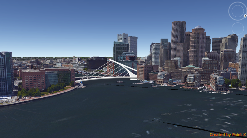
That bridge render is pretty sweet too!
That bridge render is pretty sweet too!
^ it seems to me the question is, "What will the developer be able to extract from the state in exchange for accomodating the NSRL right of way?"
That question btw is related to but independent of the question, "How much will it cost the developer to accomodate the NSRL ROW?".
It's a negotiation.
Agreed, but it's a negotiation where the developer should tread carefully. Yes, they are accommodating the ROW, so I would support seeing the state show flexibility and let something be extracted. But the public interest of that ROW is so potentially transformative to the entire region that this is one case where I'd also support the state dropping the eminent domain hammer if the site developer over-reached. That ROW absolutely must trump site concerns, and the developers must understand that, or be made to understand that. And THEN, fine.... once they realize they're negotiating from a relative weaker position, let's show them some flexibility.
My vote on what the state should do would be to say they can just skip underground parking (if they want to - might not). That'd save them a ton of money and make the job of avoiding the ROW a hell of a lot easier. And easily justifiable as a one-off exemption due to the unique underground circumstances (by justifiable as a one-off, I mean being able to say no to every other developer who tries to ride the coat-tails and get similar exemptions just via proximity). The state and BPDA would have to coordinate here, as this spills over from waterfront zoning and NSRL ROW issues - state's domain - and into issues of what other developers will want nearby - BPDA's domain.
Man, height at this spot changes so much. It could be on the top of the hierarchy chart if it's built taller then it's neighbors. Not necessarily as tall as International Place behind it, but needs to be taller than the buildings on each side.
That bridge render is pretty sweet too!
I disagree that this needs to be any particular height. It IS a highly visible site, so it'll be a drag if anything boring goes in at whatever height. But the ROW underneath it must absolutely drive all else. If that constraint allows it to go higher than what's on either side, I'd be fine with that, up to about the height of the Intercontinental as my own preferred max. I like the way there's a step up, generally, from the water side of the greenway to the other side. The obvious glaring exception to that being those pillars of Ugly, the Harbor Towers, which I'd dearly love to see evacuated and then removed via air strike.
From an aesthetic perspective, what this needs is quality, not height. And potentially it might need some seriously interesting subterranean work to support it clear of the ROW, but that's outside my realm of expertise. But above ground, I'd love to see a truly great piece of work go in there to act as a sentinel to whatever gets built for a replacement bridge.
I also like stick n move's Guinness Bridge. That is what you're calling it, right, stick?
stick n move
Superstar
- Joined
- Oct 14, 2009
- Messages
- 13,482
- Reaction score
- 24,540
Man, height at this spot changes so much. It could be on the top of the hierarchy chart if it's built taller then it's neighbors. Not necessarily as tall as International Place behind it, but needs to be taller than the buildings on each side.
That bridge render is pretty sweet too!
I submitted that to the BRA a long time ago in a public design competition...and it wasnt what they were looking for, at all. Made too much sense from a practicality standpoint if you look at what won. They wanted frills and unrealistic fluff that they could easily excuse later on and point to as the reason why its still not built 20 years from now. One of the winners blocked the entire channel from boat traffic. I gave them a cheap but visually interesting/bordering iconic (they wanted this) no frills means of getting people, cars, bikes across the water. At the same time theres waaaay better things to blow money on than this underutilized bridge, so Im not mad at all. They asked and I delivered, but this isnt the place for a bridge like this, not with another bridge one street over. So might as well forget that that render exists. Id delete it to remove distractions but its been quoted a few times.
Last edited:
I disagree that this needs to be any particular height. It IS a highly visible site, so it'll be a drag if anything boring goes in at whatever height. But the ROW underneath it must absolutely drive all else. If that constraint allows it to go higher than what's on either side, I'd be fine with that, up to about the height of the Intercontinental as my own preferred max. I like the way there's a step up, generally, from the water side of the greenway to the other side. The obvious glaring exception to that being those pillars of Ugly, the Harbor Towers, which I'd dearly love to see evacuated and then removed via air strike.
From an aesthetic perspective, what this needs is quality, not height. And potentially it might need some seriously interesting subterranean work to support it clear of the ROW, but that's outside my realm of expertise. But above ground, I'd love to see a truly great piece of work go in there to act as a sentinel to whatever gets built for a replacement bridge.
I also like stick n move's Guinness Bridge. That is what you're calling it, right, stick?
Good points. Quality indeed.
I submitted that to the BRA a long time ago in a public design competition...and it wasnt what they were looking for, at all. Made too much sense from a practicality standpoint if you look at what won. They wanted frills and unrealistic fluff that they could easily excuse later on and point to as the reason why its still not built 20 years from now. One of the winners blocked the entire channel from boat traffic. I gave them a cheap but visually interesting/bordering iconic (they wanted this) no frills means of getting people, cars, bikes across the water. At the same time theres waaaay better things to blow money on than this underutilized bridge, so Im not mad at all. They asked and I delivered, but this isnt the place for a bridge like this, not with another bridge one street over. So might as well forget that that render exists. Id delete it to remove distractions but its been quoted a few times.
I saw the concept for a "Highline" like space in the Seaport but I've always thought a mini version of it would be awesome on that bridge. Seasonal vendors and nice plantings. It would take away from car transport but would be a great pedestrian experience.
odurandina
Senior Member
- Joined
- Dec 1, 2015
- Messages
- 5,328
- Reaction score
- 266
it would help if the northern ave. bridge wasn't about to disintegrate. ....One would have to imagine that restoration, or at a minimum, complete dismantling, of the bridge should take place....
https://www.youtube.com/watch?v=q951qv7EbKs