Regional Rail (RUR) & North-South Rail Link (NSRL)

Re: Government Crossing or Downtown Center station

Exactly, and a big part of the future proofing was making sure the portal alignments to access the tunnel were protected. Move the tunnel, and you screw up the provisions for the needed portals.

Was wondering if somewhat more detailed plans for the N-S tunnel already exists given that planning for it was part of the Big Dig. Seems the $2 million study would be bolstered by dusting off those plans.
 
Re: Government Crossing or Downtown Center station

Was wondering if somewhat more detailed plans for the N-S tunnel already exists given that planning for it was part of the Big Dig. Seems the $2 million study would be bolstered by dusting off those plans.

The basic layout is pretty set (there is basically only one set path to build the tunnel). The sequence and options (2 track, 4 track, which portals first, Central Station or not; which lines through run to which terminus, when) are very much up in the air.

See:
http://www.northsouthraillink.org/alignment/
 
Re: North-South Rail Link

Hey so that article included a link to the NSRL Schematic Design Report from back in the 90s or whenever, which I've been looking for forever.

Highlights:

32074204103_4c38eec350_b.jpg


32074204043_ba2a861f34_b.jpg


32074204153_63b40d172f.jpg
 
Re: Haymarket and Aquarium

Is there any good reason why none of the official reports consider a platform under the Tip O'Neil Tunnel with the southeast end near the intersection of Atlantic Ave and Cross St, and the northwest end around Hanover St? That would be right around 1050 feet, and presumably it could be connected to both Haymarket Station and Aquarium Station for transfers to the Orange, Green, and Blue lines.
 
Re: Government Crossing or Downtown Center station

I think that might be more in line with crazy transit pitches - there is already a clean filled tunnel ready to go under the big dig that was future proofing for the NSRL. Given the question mark of financial feasibility already even with this, I don't think brand new deep bore tunnels would be in the cards for it.

Was the construction of the Porter Sq Red Line tunnel through bedrock some sort of financial disaster that I've somehow never read about? And is there any clear evidence that Porter Red Line style construction wouldn't work here? I certainly think that we don't have enough information to know if this would actually be feasible to construct, but if you had a time machine, would you go and find the person who first suggested building the Porter Sq Red Line segment through bedrock, and try to convince that person that there were at the time too many unknowns to even study building that part of the Red Line through bedrock?

Since each station is a substantial expense, having a configuration where a single station connects to all of the Red, Orange, Green, and Blue lines might end up saving significant money if it turns out to be feasible, vs building two or three stations with the I-93 alignment.
 
Re: Government Crossing or Downtown Center station

Exactly, and a big part of the future proofing was making sure the portal alignments to access the tunnel were protected. Move the tunnel, and you screw up the provisions for the needed portals.

It seems pretty likely that an NSRL alignment going under the Dewey Square tunnel would need Back Bay portal(s) a bit to the west of where the Fort Point Channel alignment proposes to put them, and the orange line that shows up on Google Maps when you turn on transit mode doesn't look like it necessarily is really in exactly the right place, but the distance from the point where the Orange Line tunnel turns to the north to Harrison is probably about 1000', which at a 3% grade provides about 30 feet of elevation difference, which is probably enough for an eastbound train coming from Back Bay to descend enough to pass under I-90. (And it might add the cost of needing separate portals for Worcester side vs Providence side.)
 
Re: North-South Rail Link

As time goes by, I'm persuaded that we should have a 2- track CR tube with stops only at NS & SS and try to get a second Red Line subway tube on the other (which could have a Central Station.

If we're going to have subway system trains under the Tip O'Neil tunnel, I'm wondering if having Green Line trains serve Haymarket then Aquarium then Courthouse might make sense. That alignment would certainly be a more direct way to get from Union Sq Somerville to Courthouse Station than the proposal via Ink Block we've seen discussed, although I'm not convinced that building Green through NSRL will ever happen given its relative place in the priority list of transit projects.

(This would presumably require a new tunnel across at least part of Fort Point Channel, and it if turns out to be impossible to get a tunnel to go between the existing near-surface Haymarket platforms and the deep NSRL Central Station location, it might involve new deep Green Line platforms for Haymarket and North Station.)
 
Re: North-South Rail Link

Joel,

To pick out a few of your points:

- Re: station location ... I think there is an expectation that being able to transfer from terminating surface trains to through-running tunnel trains @ NS & SS is important, so most plans/proposals have assumed at least underground stations serving each surface terminal. The service to the BL is usually the one with questions marks - whether it can best be served with a bit of a walk from either underground station or via 'Central Station' is very much a live question. I personally have also thrown around the possibility of a BL extension from Bowdoing to NS (either Bowdoin-Charles-NS, or Bowdoin-NS-Charles) but i think thats just a 'Crazy Transit Pitch'.

- Routing: I think the Porter comparison is an apt one. A devils advocate might point to the persistent leaks at Porter Station as a cautionary tale - but theyre not really a deal-breaker for the Alewife extension either. Clearly the challenges downtown are as much structural as they are 'only' geological. Bottom line for me - I understand the practicality of sicking to the incumbent routing for the purposes of focused advocacy and streamlined execution - but i'm not convinced that it is invevitable on the (geo-)technical merits alone

- Gl from the north: I like the idea of a greenway routing crossing the channel to Courthouse. A related possibility is to route GL down NSRL to SS, then pull a 180 in the existing bus turnaround and use the SL tunnel to cross the channel. This is the antithesis of what F-fline likes to call the 'pretty parallel lines' fallacy: it would look sort of a bonkers on a map, but in terms of service timing and constructabiity, it might actually make sense
 
Re: Newburyport / Rockport / Danvers and the NSRL

The basic layout is pretty set (there is basically only one set path to build the tunnel). The sequence and options (2 track, 4 track, which portals first, Central Station or not; which lines through run to which terminus, when) are very much up in the air.

I think there are probably two viable ways to get Newburyport / Rockport / Danvers trains to a Fort Point Channel station: the obvious routing via Chelsea and under the Tip O'Neil Tunnel, or via the rail ROW that largely runs on the east side of Chelsea Creek, then along the East Boston Haul Road, a stop at Airport Station, and along the East Boston Greenway and then a tunnel under the harbor, probably built using techniques similar to those that were used to build the Ted Williams Tunnel.

The Tip O'Neil routing would probably end up providing better Green Line connectivity, but on the other hand, if those commuter trains end up with a routing that serves Lynn (which might get Blue Line someday), Airport (Blue Line connection), South Station under Fort Point Channel (Red Line and SL2 connection, possible future Green Line service), Back Bay (Orange Line), Station That Should Have Its Name Changed To Not Celebrate A Racist (sort of connection to Green Line at Kenmore), and West Station (possible Green Line connection, potentially served by A branch running from Harvard to Park), there's pretty decent connectivity.

I'm also wondering if there's any good reason we couldn't have Newburyport / Rockport trains run through to Porter, in conjuction with a commuter rail platform at Sullivan and probably also Green Line service to Sullivan. If the Blue Line gets extended out to Lynn, that could potentially mean a Blue Line connection at Lynn, Green and Orange connections at Sullivan, and Red at Porter, so that route would cover all of the subway colors, without massive tunneling cost. In a budget NSRL configuration, this might become the only routing for Newburyport / Rockport; or perhaps some Newburyport / Rockport trains could serve Porter and others could serve the NSRL.
 
Re: North-South Rail Link

i brought this over here from the Hook Lobster thread.

^ nah, I think that article is rather alarmist. The key quote is here:

The base of this tower is not that big. If they are re-reviewing the NSRL route anyway, they'll try to compensate - it's actually a blessing that we are not talking about a transit project versus one developer, but rather a zoning plan...

That doesn't make any sense. How do you do a feasibility study about deciding the route, if the tunnels are already built, and resting on their foundations?
 
Re: North-South Rail Link

- Re: station location ... I think there is an expectation that being able to transfer from terminating surface trains to through-running tunnel trains @ NS & SS is important, so most plans/proposals have assumed at least underground stations serving each surface terminal.

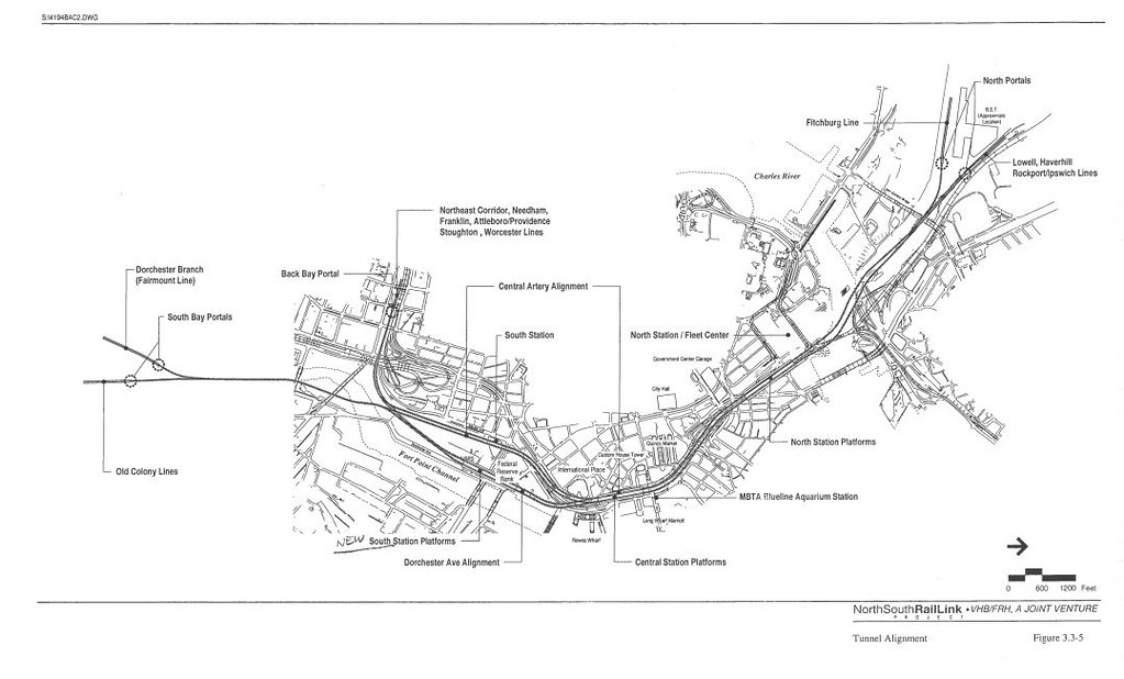
That's certainly something I haven't been thinking about much, and depending on what service patterns we end up planning on having it might end up being somewhat important. On the other hand, if the Orange Line gets extended out to Reading, and the Lowell and Haverhill via Wildcat branches run into the NSRL, and if the Fitchburg Line also runs into the NSRL and if Newburyport / Rockport were to serve Sullivan (connection to Reading service) and Porter (transfer point for Fitchburg Line), the remaining question is how to transfer from Newburyport / Rockport to Lowell Line, and maybe some platforms could be constructed near where those routes intersect. (Or in the massive-build scenario with some Newburyport / Rockport trains serving Sullivan and Porter and others serving Airport, South Station, Back Bay, etc, maybe just use the underground South Station as the Newburyport / Rockport to Lowell Line transfer point.)

Also, right now we don't send Fairmount and Old Colony trains to Back Bay to continue to West Station because they'd have to cross over most of the Back Bay to South Station tracks at grade to do so; if a lot of the Back Bay trains were to disappear into the NSRL instead of going to the South Station surface platforms, and if there was a way to get from the Fairmount and Old Colony lines to the Worcester side Back Bay platforms without an at grade conflict with Providence side Back Bay to NSRL, that might allow some Fairmount and Old Colony trains to serve Back Bay and make Back Bay work better as a transfer station between more south side lines, along with giving those lines an Orange Line connection and possibly reducing the capacity crunch on the NSRL and South Station surface platforms.

I'm wondering if it might make sense to send all Providence-side-of-Back Bay trains through the NSRL, send Amtrak Inland Route traffic through the NSRL, keep Worcester Line peak direction commuter trains going to the South Station surface platforms, give the Fairmount Line 12 minute headways to the South Station surface platforms plus 12 minute peak direction headways to Back Bay / West Station, and also give peak direction JFK to Back Bay 12 minute headways, with the idea that each of five branches (Greenbush, Plymouth/Kingston, Cape Cod, Fall River, New Bedford) could get hourly service to Back Bay. (Worcester Line reverse peak trains would then be the extension of Old Colony and Fairmount's peak direction Back Bay service, and the Worcester Line trains at the South Station surface platforms would deadhead to a yard after arriving in the morning, and deadhead from a yard in the afternoon.)

- Routing: I think the Porter comparison is an apt one. A devils advocate might point to the persistent leaks at Porter Station as a cautionary tale - but theyre not really a deal-breaker for the Alewife extension either.

Hasn't Downtown Crossing also been known to leak in heavy rain? I think the point here is that any construction technique can be leaky if it's not done well.

Bottom line for me - I understand the practicality of sicking to the incumbent routing for the purposes of focused advocacy and streamlined execution

The whole mess in New York City with ARC cancellation followed by Gateway would seem to demonstrate that if you push for a lesser projected with weaker advocacy and then get an anti-infrastructure governor, the advocates are less upset about project cancellation, and then when you finally come back to do Gateway the right way, you're even further behind on the schedule.

- Gl from the north: I like the idea of a greenway routing crossing the channel to Courthouse. A related possibility is to route GL down NSRL to SS, then pull a 180 in the existing bus turnaround and use the SL tunnel to cross the channel. This is the antithesis of what F-fline likes to call the 'pretty parallel lines' fallacy: it would look sort of a bonkers on a map, but in terms of service timing and constructabiity, it might actually make sense

I'd been thinking that being able to have Green Line trains run from Aquarium to what is currently the South Station busway might be desireable if it means you could then continue those Green Line trains toward Dudley, but I'm under the impression that the Transitway at South Station is above I-93 whereas Central Station at Aquarium is expected to end up under I-93, so I'm not sure where you have the Green Line transition from below I-93 to above I-93, and I'm also skeptical it's really a compelling enough service pattern to justify the tunneling cost. But trying to reserve space for it if it's feasible might well be worthwhile.
 
Re: North-South Rail Link

^ The only way into the Seaport transitway is from South Station-- the tunnel's curve under Russia Wharf was extremely constrained (involved ground freezing and before the Intercontinental Hotel was built).

If the NSRL (whether by CR or RedX) gives many from the north a good ride to SSU, a connection to the Silver will be fine (spoken as a Northsider)

I keep coming back to the best light transit to fill the role of a single seat ride Lechmere to Seaport would be a surface Congress St HOV/BRT line (for another thread)

Back to the impingement threat posed by this Hook Lobster tower's foundation. Does it eliminate all NSRL options or just a Dot Channel one?
 
Re: North-South Rail Link

F Line, where are you?
 
Re: North-South Rail Link

Wow he hasn't posted in over a month. That's sad, he was one of the most knowledgeable members of this fourm. Hope you're alive and well f-line.
 
Re: North-South Rail Link

F-line is alive and posting on the railroad.net forums.
 
Re: North-South Rail Link

F Line, where are you?

He's probably swamped in work again. He's taken breaks in the past when his paying gig gets a bit too packed. (Last one I think was a year ago, so probably in the midst of an annual upswing period.)
 
Re: North-South Rail Link

F Line, where are you?
He's given his NSRL-vs-Hook answer on Railroad.net
I'll summarize his 4 points:
  1. Bostinno article conveys "unnecessary alarmism."
  2. Tunnel is at its max depth (100ft down) @ Hook so it may be possible to tunnel below properly-planned foundation elements (the State is on it)
  3. It is still early in the site approval process ("People arguably need to be more concerned about City institutions being unable to get things done here than MassDOT risking an approvals brainfart deep underground.")
  4. SSX is still needed.
 

Back
Top