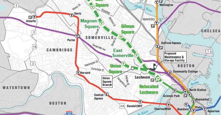
I've always had the same concern about the Union Square station design blocking westward Green Line extension. It absolutely has to be designed to allow that.
As for 4 track space west of the station, the only pinch point is at Porter Square which I think could be solved through a short tunnel and/or shifting all the tracks south just east of Mass Ave for a short stretch.
It seems to me that they set themselves up for going west of Union Sq but given other considerations did not build the northern track "ready to go onward"
Instead, as you can see from
pages 8 & 9 of the Station Final Design boards, they did a reasonable job:
1) Station entry is via a full width plaza and access to a center platform. They did build this plaza and a 1-story accessory structure (employee bathrooms for shift/rotation use) that are "in the way" but they didn't stack anything elaborate on it. When going onward, they're going to have to re-do the entrance and tie it into prospect st differently. The "elevator by others" that does tie U2 into the Prospect St overpass is only half-future proof: I believe the point is that the overpass itself isn't future-proofed enough to be worth tying into.
Prospect St Bridge, The (existing)
Electrical Substation,
2)
Getting under Prospect St s the next big obstacle.
Google Earth view suggests it has just two track berths, so there isn't clearance for the GLX to go under it, and that going onward was always going to require demolishing and rebuilding Prospect St bridge. As part of that rebuilding, a new entrance on that end was going to be called for, I'm guessing
3) There *is* a big
electrical substation *directly* in the path of the future extension. That'd have to get moved anyway. In discussions here, we've thought they have space (immediately to the north of the current substation) but it didn't have to be moved for the USq station, so they didn't touch it.
Seems like they thought ahead for:
4)
Webster-Newton bridge is also pinched underneath, but it looks like they've lined up the GLX to be able to fit under the existing bridge (which seems to have just barely 4 tracks worth of clearance under)
 IMG_7325
 IMG_7326
 IMG_7334