A question. What about the existing station/fire code triggered the need for additional exit stairs in the first place? It looks like they'll have to expand the station footprint at platform level just to accommodate them.
You are using an out of date browser. It may not display this or other websites correctly.
You should upgrade or use an alternative browser.
You should upgrade or use an alternative browser.
MBTA "Transformation" (Green Line, Red Line, & Orange Line Transformation Projects)
- Thread starter Arlington
- Start date
HBH
Senior Member
- Joined
- Apr 17, 2018
- Messages
- 1,564
- Reaction score
- 4,750
It was this rendering that threw me off, the two fare gates and the large glass wall (and emergency exit door?) and random boxed off room to the side. It just seems odd, I'm definitely exaggerating my complaints slightly I suppose. I'm also not a fan of the above ground design language, the large glass boxes replacing what we're pretty tasteful small head hours for the stairs, I imagine at least partly because they want doors now.Not sure what you mean about the underground layout. The layout at platform level doesn't seem to be changing much except for the addition of elevator shafts.
As for the new emergency stairs, fire codes these days are much stricter than what they were when Symphony was built. Off the top of my head I don't know the exact numbers, but it's usually measured in an amount of time it would take to reach a "designated place of safety" which is usually outdoors, but for wheelchair users can sometimes be a random boxed in room like above. The standard has to be met from every point on a platform and for a station like this it can be challenging to meet the standard at the ends of the platform which are far from the entrance to the station. If I had a guess, that's the reason for the fenced off area of platform on the outbound platform. This is all based on memory, but I recall the original plans had an emergency egress stair here as well which looks to be gone.
RandomWalk
Senior Member
- Joined
- Feb 2, 2014
- Messages
- 3,793
- Reaction score
- 6,817
Building codes dictate how certain things must be laid out, which will constrain how designers can work. The T also likes to standardize their design language as much as possible.
Yeah; according to Wikipedia: "A sub-passage connected the two platforms; it was sealed off in the early 1960s when the MTA converted the station to no longer need employees present."
You can see it in the MTA's original plan for the station from 1960
If it was closed so they could remove staff...why are they building two staff rooms, two customer service areas, and two restrooms? Seem unnecessary for such a minor station.
Also:
Raised station platform to accommodate level boarding for current Green Line Trains
•Station designed to accommodate future raising of platform for new green line train cars for level boarding
Really.
- Joined
- May 25, 2006
- Messages
- 7,064
- Reaction score
- 1,990
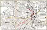
I'm currently working on a Boston track map of all the past officially proposed system expansions and I've hit a snag.
Back story: In 1926 the Commonwealth (as in NOT BERy) proposed that what is today the Green Line be split up and converted to heavy rail. The East Boston Tunnel (now Blue Line) was to be connected to Park St and run down to Kenmore Sq with the subway being extended down Comm Ave to Warren St. Here they'd build a large streetcar to heavy rail transfer stations (think the old Ashmont). The Tremont St subway would be extended to Mission Hill via the Boston and Providence RR (now NEC) similar to how the Orange Line was eventually built. The tunnel would have run as far as Tremont and Huntington where there would be a large loop.
Now I know I've seen these plans somewhere, maybe even here. All I can find online is the image I've attached and a scanned copy of the report. (https://babel.hathitrust.org/cgi/pt?id=mdp.39015049422689&view=1up&seq=1) [page 109 has the haf scanned map.] The problem is this scan doesn't include the full maps! Does anyone happen to have a full scan or copy of these maps?
Attachments
The EGE
Senior Member
- Joined
- Jun 29, 2013
- Messages
- 1,902
- Reaction score
- 5,245
Really.
The Type 10 cars will almost certainly be designed for a platform height of 12-14 inches, providing true level boarding with no need for ramps. This is standard for new light rail systems in the US. However, these platforms can only be constructed after all Type 7 and Type 8 cars are gone, as their folding doors will strike platforms higher than the 8 inch platforms currently in use. (The sliding doors on the Type 9 cars should be compatible with the future platforms during the transition period.)
The EGE
Senior Member
- Joined
- Jun 29, 2013
- Messages
- 1,902
- Reaction score
- 5,245
Now I know I've seen these plans somewhere, maybe even here. All I can find online is the image I've attached and a scanned copy of the report. (https://babel.hathitrust.org/cgi/pt?id=mdp.39015049422689&view=1up&seq=1) [page 109 has the haf scanned map.] The problem is this scan doesn't include the full maps! Does anyone happen to have a full scan or copy of these maps?
Sadly, the only scans I ever saw were those of Ward Maps, and for whatever reason they were never put on their newer site. If you email them, it's possible they might allow you access to the scans. (Since they're not on the new site, they're not attempting to make money selling reproductions anyway).
The report is in a number of libraries including Harvard, MIT, and the State Library. You might be able to ask for scans, or be able view the item yourself.
F-Line to Dudley
Senior Member
- Joined
- Nov 2, 2010
- Messages
- 9,970
- Reaction score
- 12,303
The Type 10 cars will almost certainly be designed for a platform height of 12-14 inches, providing true level boarding with no need for ramps. This is standard for new light rail systems in the US. However, these platforms can only be constructed after all Type 7 and Type 8 cars are gone, as their folding doors will strike platforms higher than the 8 inch platforms currently in use. (The sliding doors on the Type 9 cars should be compatible with the future platforms during the transition period.)
And if constructed intelligently, the provisional 8-inch platform can probably be topped off by precast interlocking slate slabs 4 inches thick blitz-installable in the span of a single weekend. There wouldn't be a need for doing over the whole floor with a time-consuming new concrete pour staged in piecemeal sections like was necessary when all stops were raised from 0 to 8 inches (which also entailed a complete ground-up resurfacing of 100-year old flooring).
IF constructed intelligently enough. . .
Charlie_mta
Senior Member
- Joined
- Jul 15, 2006
- Messages
- 5,150
- Reaction score
- 7,778
A few years ago I stumbled across files on the internet of the plans for the proposed facilities in the 1926 report, but only downloaded the section from Scollay Square to Park Street, which is this one:I'm currently working on a Boston track map of all the past officially proposed system expansions and I've hit a snag.
Back story: In 1926 the Commonwealth (as in NOT BERy) proposed that what is today the Green Line be split up and converted to heavy rail. The East Boston Tunnel (now Blue Line) was to be connected to Park St and run down to Kenmore Sq with the subway being extended down Comm Ave to Warren St. Here they'd build a large streetcar to heavy rail transfer stations (think the old Ashmont). The Tremont St subway would be extended to Mission Hill via the Boston and Providence RR (now NEC) similar to how the Orange Line was eventually built. The tunnel would have run as far as Tremont and Huntington where there would be a large loop.
Now I know I've seen these plans somewhere, maybe even here. All I can find online is the image I've attached and a scanned copy of the report. (https://babel.hathitrust.org/cgi/pt?id=mdp.39015049422689&view=1up&seq=1) [page 109 has the haf scanned map.] The problem is this scan doesn't include the full maps! Does anyone happen to have a full scan or copy of these maps?

The rest I didn't download at the time, but wish I had. I looked for them today on the Norman B. Leventhal maps and the WardMaps LLC websites but couldn't find them.
- Joined
- May 25, 2006
- Messages
- 7,064
- Reaction score
- 1,990
They were so successful building it into the Old State House they figured they'd go for broke.
F-Line to Dudley
Senior Member
- Joined
- Nov 2, 2010
- Messages
- 9,970
- Reaction score
- 12,303
How much nod did historical preservation truly get in 1926? Not much. That was the decade we started widening narrow downtown streets into giant-assed arterials the first time around in places like Adams Sq., so there was already lots of very old row buildings of some historical significance getting wiped off face of the earth on an annual basis in the name of "progress". Auto-centric urban renewal didn't start in 1954...it had already been quite the trend for a few decades prior.
- Joined
- May 25, 2006
- Messages
- 7,064
- Reaction score
- 1,990
I was able to get in contact with Steven at Ward Maps and he graciously added the 1926 report to the online collection. https://bostonintransit.com/collect...-facilities-in-the-metropolitan-district-1926
Charlie_mta
Senior Member
- Joined
- Jul 15, 2006
- Messages
- 5,150
- Reaction score
- 7,778
That is awesome. I really appreciate it.I was able to get in contact with Steven at Ward Maps and he graciously added the 1926 report to the online collection. https://bostonintransit.com/collect...-facilities-in-the-metropolitan-district-1926
")
The EGE
Senior Member
- Joined
- Jun 29, 2013
- Messages
- 1,902
- Reaction score
- 5,245
What is the NB TOD at Kendall? The only headhouse plans that I'm familiar with are for the southbound headhouse.
Equilibria
Senior Member
- Joined
- May 6, 2007
- Messages
- 7,229
- Reaction score
- 8,759
What is the NB TOD at Kendall? The only headhouse plans that I'm familiar with are for the southbound headhouse.
Boston Properties is rebuilding the northern one as a part of 325 Main. I believe this is current:
bigeman312
Senior Member
- Joined
- Jul 19, 2012
- Messages
- 2,408
- Reaction score
- 2,511
Oh for pity’s sake... as @vanshnookenraggen can attest, peeps really do love to yoink fantasy subway maps for their own work.
bigeman312
Senior Member
- Joined
- Jul 19, 2012
- Messages
- 2,408
- Reaction score
- 2,511
Yesterday's Report from the General Manager included some relevant slides that are worth posting here:


Summarized Key Points Related to the OL/RL/GL "Transformation" Projects:
It appears the T has never been less usable, even including the meltdown of 2015, than it will be in 2021. It's quite arguably that this is necessary long-term, so I'm not even making a value judgment, just a presentation of the services being offered this year.
Summarized Key Points Related to the OL/RL/GL "Transformation" Projects:
- Shuttle bus between Oak Grove and Sullivan through 4/11 as a result of the derailment. A historic 26-day, unplanned suspension of Orange Line service between Sullivan and Oak Grove. This must be the largest unplanned service disruption of the Orange Line in the MBTA era.
- New OL cars out indefinitely ("until investigation is completed").
- Three weekends with suspended service planned for Sullivan-Oak Grove in the fall while the new signal system begins testing.
- Six weekends with suspended service planned for the north side of the Red Line in the fall related to the new signal system.
- Kenmore-Babcock service will continue to be suspended weekends (and early access) through October as part of the B Branch Station Consolidation. According to this schedule, it appears that the MBTA is planning on "Late 2021" to mean October for station consolidation project completion, which would be great if it happens.
- Most of the B-Branch (Kenmore-Washington St) will be suspended from April 17 - May 9 and May 17 - June 13 as part of that B Branch Station Consolidation.
- Full D-Branch suspension (Kenmore-Riverside) aon weekends through the end of the year and 24/7 from April 17 - May 9 and May 17 - June 13 as part of the Green Line D Track and Signal Replacement. Seems like that project's completion has been quietly pushed back from "Fall 2021" to end of year.
- Symphony Station Accessibility Improvements is also going to cause suspension of the E-Branch for an undefined period of time in August/September as well as weekends starting in November.
It appears the T has never been less usable, even including the meltdown of 2015, than it will be in 2021. It's quite arguably that this is necessary long-term, so I'm not even making a value judgment, just a presentation of the services being offered this year.