The LA and Orange County region is wild. Basically the big LA basin (and the OC flats) are almost fully developed, add the San Fernando Valley which is also there in the City of LA. Also in LA county, the additional development on the Antelope Valley and add the growing Inland Empire counties and you have maybe 7 separate regions bordering each other forming the one mega region. Not only is there a mega region but all the subdivisions are pluricentric with several major centers not just one singular center of gravity.Yeah, L.A. has a very different topography than most cities in that it completely fills a geographically constrained basin, with very little outside of that area, but contained within it are multiple large CBDs. The freeway system there reflects this in its lattice-like appearance, as did the old Pacific-Electric network. The modern MTA rail network, both as it is now, and as it will be 15-30 years from now also follows the lattice design.
You are using an out of date browser. It may not display this or other websites correctly.
You should upgrade or use an alternative browser.
You should upgrade or use an alternative browser.
If You Were God/Goddess | Transit & Infrastructure Sandbox
- Thread starter George_Apley
- Start date
NoShJFK
Active Member
- Joined
- Apr 18, 2021
- Messages
- 119
- Reaction score
- 136
A very conceptual/high level question:
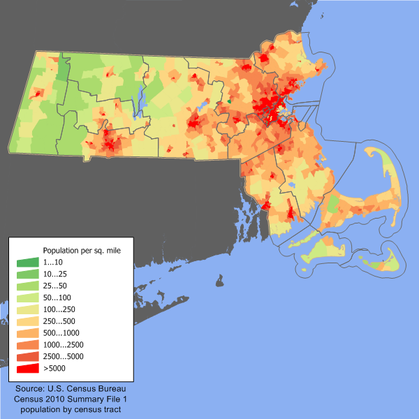
Ignoring everything but population densities and distributions, what would be the furthest out it would make sense to build the colored lines of the MBTA? Not counting the buses (yellow) or any permutation of the commuter rail (indigo). Basically, if you had a complete do-over to build the Green, Red, Orange, and Blue lines from scratch and had an effectively unlimited construction budget, how far out would each go? Would it just be out to 128 in all directions, or would any towns further out make sense to connect into the core network? I threw a population density map in for reference.
This is a very interesting question but one that also seems pretty straight forward.
In a god mode scenario where property acquisition, cost, NIMBY and political will were all non issues and the only thing that mattered is adequate ridership, use and purpose: You get 128 as your answer. In most cases anyway
Blue Line
NORTH: Downtown Salem or "Peabody 128" at NS Mall (via Jackson, Boston, Main St - a 3.3 mile tunnel). This is the most transit ripe area. Unfortunately it's so dense and developed that almost any route other than following the Eastern ROW is an enormous expense. But as far fetched as it is in today's environment - virtually any major extension into this area even via tunnel would be well worth it. Downtown Salem, Salem State, Downtown Beverly, Peabody Square, Wyoma Square, Central Square, Western Ave.
SOUTH: Riverside - Kind of obvious. It's right at 128. At the limit of real density for that area
Red Line
NORTH: Arlington Center (maybe Arlington Heights) - Some would say Burlington but I just don't think there is justification for it. Unless you're alright with an INSANE gap between Arlington Heights and Burlington. There aren't many legitimate infill chances in between IMO.
SOUTH: Braintree is it.
Green Line
NORTH: Woburn Center - Pushing through Winchester it gets dicey (as to legitimate justification) But Woburn, especially being that its on the 128 belt meets the requirements for me. This is with MODERN LRT technology. With trolley technology - Tufts is as far as I'd go.
Orange Line:
NORTH: Reading. I'm extremely bullish on the Reading/Stoneham area. The population isnt very high but it's dense enough and with proximity enough where I think you could justify it. Wilmington gets transferred to the Lowell CR line or cancelled all together. Reading SOUTH becomes HRT. Preferably with express tracks. Yes it would make for a somewhat long route for a rapid transit line however with express tracks its decent
SOUTH: Dedham. Again, near 128.
themissinglink
Senior Member
- Joined
- Jan 13, 2018
- Messages
- 2,040
- Reaction score
- 5,623
NORTH: Arlington Center (maybe Arlington Heights) - Some would say Burlington but I just don't think there is justification for it. Unless you're alright with an INSANE gap between Arlington Heights and Burlington. There aren't many legitimate infill chances in between IMO.
There's certainly infill opportunities between Arlington Heights and Burlington. East Lexington, Lexington Center, North Lexington...
Green Line
NORTH: Woburn Center - Pushing through Winchester it gets dicey (as to legitimate justification) But Woburn, especially being that its on the 128 belt meets the requirements for me. This is with MODERN LRT technology. With trolley technology - Tufts is as far as I'd go.
IIRC the ROW into Woburn Center is no longer build-feasible. I'd bring it all the way to Anderson RTC in a full-build extension scenario.
SOUTH: Dedham. Again, near 128.
The ROW south of West Roxbury through Dedham has been built over in a couple spots, the furthest you'd be likely to go on the south side would be a station at VFW Parkway (or possibly only to West Roxbury, omitting the VFW Parkway station but keeping the yard at that location)
There's certainly infill opportunities between Arlington Heights and Burlington. East Lexington, Lexington Center, North Lexington...
Lexington Center I can get on-board with, but the other two seem more questionable, at least for HRT. I could see a better fit for a LRT line that runs into a transfer station at Arlington, Alewife, or Porter.
That being said, I do think Burlington's "edge city" is a big enough prize that it could be worth having a long gap. But Burlington might be better served by some sort of shuttle (rail or otherwise) based out of a transit hub at Anderson Woburn.
EDIT to add:
IIRC the ROW into Woburn Center is no longer build-feasible. I'd bring it all the way to Anderson RTC in a full-build extension scenario.
Looking at the map, I think the southern half of the Woburn loop is still largely recoverable? (Depending on how close to Woburn Center you're trying to get.) The northern half is definitely gone though.
F-Line to Dudley
Senior Member
- Joined
- Nov 2, 2010
- Messages
- 9,970
- Reaction score
- 12,304
Looking at the map, I think the southern half of the Woburn loop is still largely recoverable? (Depending on how close to Woburn Center you're trying to get.) The northern half is definitely gone though.
Stop & Shop right at Winchester Jct. was built on top of it, as was a single-family home on Cross St. The rest is mostly intact on visual inspection, but the MBTA sold off the ROW after abandonment so the property lines are obliterated out to Cross St. Few dozen property owners would have to be directly negotiated with, and that's not going to go well. Property lines are intact under town ownership past Cross, but there are some structural encroachments shown on Google.
The S-curve in Downtown where it crosses Main St. then stopped behind City Hall for the station was also pretty nasty for its tightly-packed grade crossings in a congested area. It's all parking lots now...including City Hall's only lot. Abbott St. with all its angled parking was a whole new connecting block laid on top of the ROW post-abandonment. Re-stitching something together through there would've been hella awkward. They'd probably have had to curtail the LRT line a couple blocks south of City Hall just to avoid all the weaving through crossings.
Ironically, the north half of the Loop is much clearer than the present-day south half when it comes to property lines. The west half of the Main St. exit rotary under 128 was built on the former rail bed, but isn't exactly load-bearing in function. Rest of it is mercifully clear because it's contoured by the banks of Willow Brook. Most of that's going to be trailed sooner than the south half ever will.
Connecting to Burlington that way might be usefulYou might be able to sneak a Type 10 behind the market, but F-Line is right about the ROW being a courtroom catfight. MAYBE front door service to Downtown MIGHT be an inducement to some owners.....
themissinglink
Senior Member
- Joined
- Jan 13, 2018
- Messages
- 2,040
- Reaction score
- 5,623
Lexington Center I can get on-board with, but the other two seem more questionable, at least for HRT.
I'd certainly agree that stations at East Lexington and North Lexington would be somewhat questionable in a Red Line to Lexington/Burlington extension, but I figure they would likely be included to maintain appropriate stop spacing. The East Lexington station is certainly more questionable due to the relative lack of density around the station site, but it would at least have a connection to the Lexpress C bus. The area surrounding the North Lexington station site is certainly more dense than East Lexington (albeit it's mostly single-family residential) but it lacks a direct connection to any of the Lexpress buses (perhaps the Lexpress A bus could be slightly rerouted up Bedford Street to stop at the station).
Someone more knowledgeable than me could probably provide better insight to whether stations at North Lexington or East Lexington would be appropriate in a Red to Lexington/Burlington scenario.
F-Line to Dudley
Senior Member
- Joined
- Nov 2, 2010
- Messages
- 9,970
- Reaction score
- 12,304
You might be able to sneak a Type 10 behind the market, but F-Line is right about the ROW being a courtroom catfight. MAYBE front door service to Downtown MIGHT be an inducement to some owners.....
Kinda doubt it. The Cross St. intermediate was 6 blocks down the street from Winchester Highlands on the mainline (closed 1978). Terrible ridership at both stops, but the Woburn Branch stop got more all-day service vs. the mainline which had extremely stark peak vs. off-peak divide in the early MBTA era. The Downtown stop was central enough, but former-and-future Montvale Station on the mainline splits the equidistant difference between Downtowns Woburn & Stoneham and only needs one decent-frequency bus pinging the length of the road between the two town centers to likely serve up a superior-overall audience from the dual catchment (separate Stoneham Branch service was KO'd by B&M in the '58 service cuts, and it remains a bus desert to this day). Just make the frequencies on the spanning bus a 15-min. match for scheduled Urban Rail scheduled stops and it should sizzle immediately.
The primary problem with the Woburn Branch was the grade crossings. There were something like 20 of them of the whole circuit between mainline junctions, and 8 or 9 on the 2-mile downtown ping. That's the same number GLX Needham Branch would traverse, but in only half the mileage with more speed-inhibiting clusters of them. It wouldn't be a fast-moving trolley by any stretch, and would probably by all practicality have to terminate 3 blocks south of Woburn Common a smidge off-center to avoid the horrible-geometry S-curve into the old City Hall station. Had they given it any additional study development it might've paled in a project weighting comparison to simply doing up a 2 x 2 ROW on the mainline that could support faster/denser service levels...since between the '45 BTC map and 1955 B&M had spent some considerable $$$ going and zapping a whole slew of Winchester-Woburn mainline grade crossings to seal the whole corridor to Chelmsford excepting the tricky remaining West Medford pair.
Charlie_mta
Senior Member
- Joined
- Jul 15, 2006
- Messages
- 5,150
- Reaction score
- 7,778
Really stupid of the MBTA to give up the ROW to the Woburn Branch, as well as the Watertown Branch in Watertown and Waltham. After all, a Green Line to Woburn was clearly shown in the 1945 plan, and some kind of rail rapid transit to Watertown and Waltham has been on the radar since the 1940s.
F-Line to Dudley
Senior Member
- Joined
- Nov 2, 2010
- Messages
- 9,970
- Reaction score
- 12,304
Lexington was chopped off early enough in the mid-70's development planning for RL Northwest that the question of how many intermediates was never answered. By the big 1976 study it was strictly an Arlington Heights corridor with the rest to Hanscom punted off to later phases. E. Lex + N. Lex were in mid-study consideration. Both were on MBTA schedules to end-of-service in '77, though because Arlington Heights was not a T-era stop (the inner stops with most bus overlap were purged, with AC + Lake St. brought back post-1968 by popular demand) its walkshed was overrepresented in the Arlington Heights direction.I'd certainly agree that stations at East Lexington and North Lexington would be somewhat questionable in a Red Line to Lexington/Burlington extension, but I figure they would likely be included to maintain appropriate stop spacing. The East Lexington station is certainly more questionable due to the relative lack of density around the station site, but it would at least have a connection to the Lexpress C bus. The area surrounding the North Lexington station site is certainly more dense than East Lexington (albeit it's mostly single-family residential) but it lacks a direct connection to any of the Lexpress buses (perhaps the Lexpress A bus could be slightly rerouted up Bedford Street to stop at the station).
Someone more knowledgeable than me could probably provide better insight to whether stations at North Lexington or East Lexington would be appropriate in a Red to Lexington/Burlington scenario.
F-Line to Dudley
Senior Member
- Joined
- Nov 2, 2010
- Messages
- 9,970
- Reaction score
- 12,304
Really stupid of the MBTA to give up the ROW to the Woburn Branch, as well as the Watertown Branch in Watertown and Waltham. After all, a Green Line to Woburn was clearly shown in the 1945 plan, and some kind of rail rapid transit to Watertown and Waltham has been on the radar since the 1940s.
State never had a crack at the Watertown Branch, as B&M and Pan Am never put it up for sale. The center third through H2O Sq. was gone by 1960 pre-MBTA, before the state had any Legislative mechanism for inserting itself into the mix. Unlike the other '45 map ROW's that were scooped up by the state in the 40's & 50's, the Arsenal was still generating bigtime traffic for B&M during the early Cold War so they held onto that one jealously during their first stint through bankruptcy in the 50's and asked the moon for the West Cambridge-East Watertown segment ID'd in the '45 map for the High Speed Line to Arlington. State got Grove St.-School St. under landbanking in 1996 through the normal Surface Transportation Board filing mechanism, West Cambridge-Grove St. in 2012. The Bemis Branch end from Waltham was functionally useless without the spanning segment (and would've never been a rapid transit candidate to begin with because the grade crossings were so all-world bad), so they never had any mandate to bother with that one.
The only lines the T ever acquired lock-stock for ownership and then sold off were:
- Woburn Branch. Acquired in 1976 in the big bankruptcy bundle sale of B&M lines while still in operation, sold off pretty quickly to the town post-abandonment (who in-turn reverted a lot of the property south of Cross St.). But again...if GLX ever made it that far for a re-study this branch was hardly a head-and-shoulders obvious routing pick because of the mainline being grade-separated throughout the area after the '45 Report ID'd the corridor and potentially being ops-superior.
- Marboro Branch, South Acton @ Fitchburg Line to Hudson @ Central Mass to Downtown Marlborough stub-end. Acquired '76 B&M bundle, brokered off to the towns in the 90's/early-00's for the Assabet River Trail. Never would've been a transit corridor candidate because the routing is kinda nutty, but whereas other landbanks were simply transferred to DCR's ledger they actually expunged this one. Don't know why...probably some obscure hyper-local politics.
- Dedham Line, W. Roxbury-Dedham Center. Acquired from the Penn Central liquidation in '73 and reserved for the Orange Line extension. Sold in 2008 to Town of Dedham so single-family homes could be built atop it the whole length of Belle Ave. That one was a truly infuriating ratfucking of transit considerations by truly terrible bought-off politicians. Town of Dedham is a well-known NIMBY hellhole, expressed by the retrograde bus desert that exists in town to this day. They were itching to salt over the ROW. I'm not sure what the state's excuse was for shaking hands with that corruption. Romney-era MassDOT executed that one. State still owns the Readville-Dedham Ctr. Dedham Branch...and the town rejected the last/best trail proposal over its fully grade-separated length...so that one is still available. Could probably link a flyover ramp from the Fairmount Line onto there with ease, and it would only require a capped-cut box tunnel (Wellington-style) where it splits the high school athletic field complex. But don't ever expect any Town cooperation whatsoever; they're hopeless out there.
Last edited:
Re feasibility of Green Line through Woburn, I will quote the OP:
Presumably God would be able to buy the Stop-and-Shop lot, and would be able to pay generously to relocate the encroaching housing (including paying the residents enough for them to take early retirement and live without want for the rest of their lives). In principle, those are both problems that could be solved with enough money and without much clever engineering.
The grade-crossings in downtown, and the tight squeeze behind City Hall... yeah, that involves physical constraints and would be much more disruptive to the village's "sense of place". Would require more "clever engineering", and probably only becomes feasible once you start tearing up the town center, which, you know, I'm sure God could do, but comes at an inherent cost.
Which I guess reveals what kind of God I'd be, haha... pay people exorbitantly to buy their houses so I can knock them down, but Thou Shalt Not Destroy The Aesthetic Of The Village.
This is your "perfect world", "wipe the slate clean", "perfect lines on the map" infrastructure sandbox thread. Got an idea for something that has no good reason other than "it would be cool"? Or an idea that is so outlandish in terms of the financial, political, ethical, and/or engineering challenges that it would never happen in a million years? This thread is your playspace. Discuss concepts but don't bring in feasibility questions here. It's just for fun.
If you want your concept critiqued for feasibility, post it over in Crazy Transit Pitches and someone will probably dig into it.
Presumably God would be able to buy the Stop-and-Shop lot, and would be able to pay generously to relocate the encroaching housing (including paying the residents enough for them to take early retirement and live without want for the rest of their lives). In principle, those are both problems that could be solved with enough money and without much clever engineering.
The grade-crossings in downtown, and the tight squeeze behind City Hall... yeah, that involves physical constraints and would be much more disruptive to the village's "sense of place". Would require more "clever engineering", and probably only becomes feasible once you start tearing up the town center, which, you know, I'm sure God could do, but comes at an inherent cost.
Which I guess reveals what kind of God I'd be, haha... pay people exorbitantly to buy their houses so I can knock them down, but Thou Shalt Not Destroy The Aesthetic Of The Village.
Blackbird
Senior Member
- Joined
- Feb 2, 2014
- Messages
- 1,246
- Reaction score
- 1,832
For my lay-person knowledge, just how impossible would it be to reroute the blue line so that it actually passes through a Logan terminal? Or to extend the terminals or build people movers between them and the station to avoid having to use the shuttle?
Got in late from Charlotte a few weeks ago and Ubers to Medford went from $20 to $50 real quick. Wasn't willing to pay that much, so I took the T to Wellington and Ubered from there. Figuring out where to get the shuttle and then waiting for it to come around was a huge pain.
Got in late from Charlotte a few weeks ago and Ubers to Medford went from $20 to $50 real quick. Wasn't willing to pay that much, so I took the T to Wellington and Ubered from there. Figuring out where to get the shuttle and then waiting for it to come around was a huge pain.
I think MassPort has a proposal for a People Mover that would largely replace the Blue Line Shuttle.
Unfortunately for funding reasons (I think) it actually would be a shared stop between a parking garage and the blue line, so a bit longer walk to the blue line than is ideal.
Unfortunately for funding reasons (I think) it actually would be a shared stop between a parking garage and the blue line, so a bit longer walk to the blue line than is ideal.
Brattle Loop
Senior Member
- Joined
- Apr 28, 2020
- Messages
- 1,176
- Reaction score
- 2,105
For my lay-person knowledge, just how impossible would it be to reroute the blue line so that it actually passes through a Logan terminal? Or to extend the terminals or build people movers between them and the station to avoid having to use the shuttle?
Got in late from Charlotte a few weeks ago and Ubers to Medford went from $20 to $50 real quick. Wasn't willing to pay that much, so I took the T to Wellington and Ubered from there. Figuring out where to get the shuttle and then waiting for it to come around was a huge pain.
The shuttle leaves a lot to be desired, and its signage is unreasonably bad. (Not sure which terminal you wound up at, some are much worse than others when it comes to finding transit access.)
That said, re-routing the Blue Line would be an engineering nightmare and flunk the cost-benefit analysis with aplomb. It'd take something like a roughly-2-mile-loop to a reasonable location for accessing the terminals (because if you're going to spend money to move the thing, getting it a couple hundred feet closer ain't gonna cut it), which for reference is roughly as long as the entire line segment between Airport and Bowdoin. Not to mention that would require tunneling under the airport roads and the central parking garage, with all the difficulty and disruption that could entail. It's probably technically possible, but completely unrealistic, meaning it's properly located here in God Mode territory.
As SomerJeff mentioned, Massport did plan a people mover, though I'm currently uncertain as to whether that was temporarily or permanently shelved in pandemic budget cuts or if it's back on as an active project. Massport's plan called for the station to be on the other side of the road from the Blue Line station so that it could also serve the economy garage; it's about 300-odd feet from the Blue Line entrance, though I don't know if they planned to grade-separate that or not. Feasible project in Reasonable Transit Pitches territory, but currently up in the air (no pun intended) due to Massport budgeting questions.
Terminal E is currently in the process of expansion which will bring the end of the terminal building to within about 600-700 feet of the Blue Line station. The plan at one point in time (as I recall this pre-dated the people mover project) called for a pedestrian walkway connecting the station to the expanded terminal building. Terminals A and E are presently connected streetside (outside security) via bridges passing through the central parking garage. Terminal E is connected airside (inside security) to Terminal C (I honestly have no idea if they're connected indoors on the streetside), and once the present work near the control tower is completed Terminal C will be connected airside to Terminal B, which would make it possible to go E-C-B inside security. They're all more-or-less connected streetside (though C's connections to the adjacent terminals may not be weather-protected presently), but even once the airside connectors are completed, the distances get crazy very quickly. (It'd be minimum 1.5 miles walking from Terminal E, not even the Blue Line, to the far side of Terminal B, rising to over 2 miles for anyone with the misfortune of flying out of the satellite terminal at Terminal A if they connect the two airside.) At present it's entirely possible to walk between the terminals and the Blue Line (I can neither confirm nor deny having walked from C to the Blue Line when the shuttle was particularly awful) but it's not ever going to be a viable mass-transit option.
Returning to this thread to toss out a pure "crayoning delight" idea that isn't so much a proposal as a thought experiment to examine our transit needs from a novel perspective.
Basically, take F-Line's brilliant "Red X" idea, and reroute one of the now duplicative segments over to the Seaport:

There are a few pieces to this and I was slightly surprised when I realized that some are not actually that crazy:

There are two concepts at play here, one of which is already covered as part of the Red-X idea.
First, reallocating the Dorchester Ave subway to the Congress Subway creates a pretty maximally straight north-south axis that makes for pretty elegant network design. (I'd argue this is one area where this idea has a slight edge over the original Red-X, which sees the Congress Line bypassing Andrew -- which isn't a knock on that proposal, it's just an area of slightly reduced elegance.)
Second, the current Red Line -- like all of Boston's subway routes -- consists of radial legs that meet in downtown at an angle. (Compare the north-south alignment of Oak Grove-Tufts Medical Center and the northeast-southwest alignment of Tufts Medical-Forest Hills.) This concept maintains that topology but relocates the curving angle from South Station to the Seaport. This, I would argue, takes the same logic that created today's Red Line and updates it for the 21st century: the Red Line turns at South Station because that once was the edge of the CBD; now that the CBD extends into the Seaport, the turn should also be relocated again toward the edge of the CBD.
Now... what would really make this concept sing would be to have the Seaport Line travel via D Street rather than Track 61. That would allow for better service deeper into South Boston, and additionally would allow you to swing wider through the Seaport, serving WTC more directly, and probably giving you space to fit two stations into the Seaport rather than one.
The "problem" with that, of course, is that it would be huge greenfield construction. Which, again, isn't a problem if God is footing the bill, and so is useful to bear in mind when considering what an "ideal" system might look like, and thereby where we should be "aiming" for with our compromises.
~~~
Now, what might make for a slightly less "If You Were God" proposal would be something like the below...

An Aldgate junction north of South Station, connecting the Transitway to a second LRT trunk through downtown via Congress St. Seaport can get high frequencies from both the north and the south, and additional capacity opens up to funnel services from Nubian, Back Bay, Huntington and beyond into downtown without touching the Central Subway. Vaguely feasible in that it shouldn't require a rebuild of South Station Under (although that many flat junctions might be unpleasant, potentially necessitating a grade-separation rebuild of the Transitway -- less feasible).
I don't think this is particularly necessary or desirable -- if you're going to bring LRT to South Station, it should continue on to the Seaport. A trunk under Congress is nice, but I think is overkill, and requires an Aldgate junction if you want to keep frequencies maximal within each of the trunks (Congress, Seaport, Hudson St). I think a Congress subway is better allocated to HRT or mainline service, rather than LRT.
But it looks pretty on the map!
Basically, take F-Line's brilliant "Red X" idea, and reroute one of the now duplicative segments over to the Seaport:
There are a few pieces to this and I was slightly surprised when I realized that some are not actually that crazy:
- Not (that) crazy:
- Reuse the Piers Transitway tunnel: IIRC, this tunnel was indeed built to Red Line specifications. I've relocated the Seaport station to one that is between Courthouse and WTC, in part to reflect HRT stop spacing, but it isn't a hugely consequential decision
- Reclaim the full Track 61 ROW (including the Haul Road) for below-grade open-trench HRT running (see map below)
- This, by the way, is my response to pretty much any Track 61 proposal: you need somewhere for it to go after reaching the Seaport; usually I figure on BRT that heads east to the airport, but here I've flipped it to run west
- Actually crazy:
- Complete rebuild of South Station Under, as the Seaport line would need to diverge west of the existing Red Line platforms if it is going to pick up the Transitway tunnel; if God is footing the bill, you could of course do a greenfield tunnel that splits off just east of the platforms
- Some sort of tunnel under the Mass Pike to connect Seaport Station and the Track 61 ROW. I have zero clue what this would entail, but I have to think it would be a massive undertaking
There are two concepts at play here, one of which is already covered as part of the Red-X idea.
First, reallocating the Dorchester Ave subway to the Congress Subway creates a pretty maximally straight north-south axis that makes for pretty elegant network design. (I'd argue this is one area where this idea has a slight edge over the original Red-X, which sees the Congress Line bypassing Andrew -- which isn't a knock on that proposal, it's just an area of slightly reduced elegance.)
Second, the current Red Line -- like all of Boston's subway routes -- consists of radial legs that meet in downtown at an angle. (Compare the north-south alignment of Oak Grove-Tufts Medical Center and the northeast-southwest alignment of Tufts Medical-Forest Hills.) This concept maintains that topology but relocates the curving angle from South Station to the Seaport. This, I would argue, takes the same logic that created today's Red Line and updates it for the 21st century: the Red Line turns at South Station because that once was the edge of the CBD; now that the CBD extends into the Seaport, the turn should also be relocated again toward the edge of the CBD.
Now... what would really make this concept sing would be to have the Seaport Line travel via D Street rather than Track 61. That would allow for better service deeper into South Boston, and additionally would allow you to swing wider through the Seaport, serving WTC more directly, and probably giving you space to fit two stations into the Seaport rather than one.
The "problem" with that, of course, is that it would be huge greenfield construction. Which, again, isn't a problem if God is footing the bill, and so is useful to bear in mind when considering what an "ideal" system might look like, and thereby where we should be "aiming" for with our compromises.
~~~
Now, what might make for a slightly less "If You Were God" proposal would be something like the below...
An Aldgate junction north of South Station, connecting the Transitway to a second LRT trunk through downtown via Congress St. Seaport can get high frequencies from both the north and the south, and additional capacity opens up to funnel services from Nubian, Back Bay, Huntington and beyond into downtown without touching the Central Subway. Vaguely feasible in that it shouldn't require a rebuild of South Station Under (although that many flat junctions might be unpleasant, potentially necessitating a grade-separation rebuild of the Transitway -- less feasible).
I don't think this is particularly necessary or desirable -- if you're going to bring LRT to South Station, it should continue on to the Seaport. A trunk under Congress is nice, but I think is overkill, and requires an Aldgate junction if you want to keep frequencies maximal within each of the trunks (Congress, Seaport, Hudson St). I think a Congress subway is better allocated to HRT or mainline service, rather than LRT.
But it looks pretty on the map!
Brattle Loop
Senior Member
- Joined
- Apr 28, 2020
- Messages
- 1,176
- Reaction score
- 2,105
- Reclaim the full Track 61 ROW (including the Haul Road) for below-grade open-trench HRT running (see map below)
- This, by the way, is my response to pretty much any Track 61 proposal: you need somewhere for it to go after reaching the Seaport; usually I figure on BRT that heads east to the airport, but here I've flipped it to run west
This is God Mode, so it's not really a criticism as such more of a theological question. My understanding is CSX has trackage rights on Track 61, and there's nothing that the state can do if they're unwilling to give them up. Does God Mode extend to getting the devil to give up his trackage rights, or is it an unstoppable force/immovable object situation?

Here's a real question unbefitting of a God Mode thread: Why do we/would we want to remove/preclude a rebuild of a freight connection to our Intermodal port? In a desired future where we can see more trucks removed by rail freight, this seems really short sighted. I get that Boston isn't the Hudson and that those days are gone, but I also don't see why Boston shouldn't have more rail freight for it's growing population.This is God Mode, so it's not really a criticism as such more of a theological question. My understanding is CSX has trackage rights on Track 61, and there's nothing that the state can do if they're unwilling to give them up. Does God Mode extend to getting the devil to give up his trackage rights, or is it an unstoppable force/immovable object situation?