JumboBuc
Senior Member
- Joined
- Jun 26, 2013
- Messages
- 2,808
- Reaction score
- 1,993
lol 2029 like “that’s way too soon never gonna happen” or lol 2029 like “oh my god that’s so long from now”?lol 2029
I feel like maybe both, somehow…
lol 2029 like “that’s way too soon never gonna happen” or lol 2029 like “oh my god that’s so long from now”?lol 2029
Yeah the old GLX contract was cancelled 6 years ago and put out for rebid. That feels like yesterday.7 years will go by so much faster than you will be comfortable with.
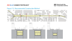
I'm disappointed that the street level plans do not have bike lanes.Red Blue Connector | Projects | MBTA
Official website of the MBTA -- schedules, maps, and fare information for Greater Boston's public transportation system, including subway, commuter rail, bus routes, and boat lines.www.mbta.com
Publishing a project page on their website is a good sign they might actually keep moving
Here's the full report on the concepts: https://cdn.mbta.com/sites/default/files/2021-12/2021-12-01-red-blue-concept-design-report.pdf
Wow, the recommended alternative in that report is cut and cover the whole thing. Maybe this time around the alternative analysis was actually done to select the best alternative instead of sandbagging the whole thing (shocking l know).
City of Boston is planning on installing bike lanes on Cambridge Street next year so I'm pretty sure an eventual rebuild would include them too, just not really something the MBTA needs to be in charge of designingI'm disappointed that the street level plans do not have bike lanes.
lol 2029 like “that’s way too soon never gonna happen” or lol 2029 like “oh my god that’s so long from now”?
I feel like maybe both, somehow…
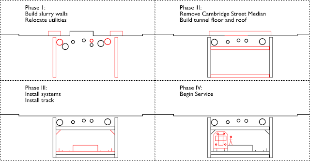
The 2010 DEIR and concept design included two tail tracks for train storage, which extended west beyond the station (Figure 5-1). The storage tracks would provide train storage of two 6-car consist trains. No trains could be stored on the tracks during revenue service - for safe braking reasons. Construction of such storage tracks west of the station are problematic from a construction cost and impact perspective, and from a tunnel ventilation and emergency egress perspective.
Potential Storage Track East of Station (Figure 5-2) provides less construction impact and greater operational flexibility.
Potential Storage Track at Bowdoin Loop (Figure 5-3) is problematic from operations perspective.
According to the design report, they're considering (and favoring) storage tracks to the east of the station, as opposed to the previously proposed storage tracks to the west of the station.
View attachment 19229
View attachment 19230
They also interestingly considered using soon to be retired Bowdoin loop for storage tracks.
View attachment 19231
Just as long as they don't screw up potential provision for future (Riverbank-to-Kenmore?) extensions for no reason...
It would be tight, but I think a future Riverbank extension is still doable. The red lines (by me) represent the tunnels that would be cut-and-cover in the future for the Riverbank extension. In any case, any Red-Blue connector design should be made to include future stubs to the Riverbank extension alignment.Just as long as they don't screw up potential provision for future (Riverbank-to-Kenmore?) extensions for no reason...

Is there any point in writing to MBTA to suggest a provision of future extensions in their design? I'm tempted to do that lol. It would be disappointing if RBC proceeds with no consideration of the possible Riverbank extension, which is a very natural one.It would be tight, but I think a future Riverbank extension is still doable. The red lines (by me) represent the tunnels that would be cut-and-cover in the future for the Riverbank extension. In any case, any Red-Blue connector design should be made to include future stubs to the Riverbank extension alignment.
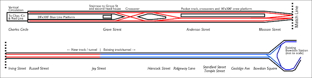
If they go with "alternative 3" for the station location they would almost definitely be blocking any provision for the riverbank subway.
View attachment 19232
Is that the southwest extension 2 you outline here: https://www.vanshnookenraggen.com/_index/futurembta/theblueline/ ?Riverbank is, and always has been, a bad choice. I prefer sending it into Cambridge and this alternative would be perfect. Of course it's not preferred.