You are using an out of date browser. It may not display this or other websites correctly.
You should upgrade or use an alternative browser.
You should upgrade or use an alternative browser.
Crazy Highway Pitches
- Thread starter DominusNovus
- Start date
Highwayguy
Active Member
- Joined
- Apr 1, 2020
- Messages
- 205
- Reaction score
- 546
Very suboptimal from a pedestrian perspective due to the circuitous routing. Also God help the guy unlucky enough to have to design the vehicular guide signs.

Blackbird
Senior Member
- Joined
- Feb 2, 2014
- Messages
- 1,246
- Reaction score
- 1,832
Any massive rotary configuration is going to be horrible for pedestrian access between Bayside - one of the biggest TOD opportunities in the entire region - and JFK/UMass station.
Isn't pedestrian access already pretty terrible?
Charlie_mta
Senior Member
- Joined
- Jul 15, 2006
- Messages
- 5,150
- Reaction score
- 7,778
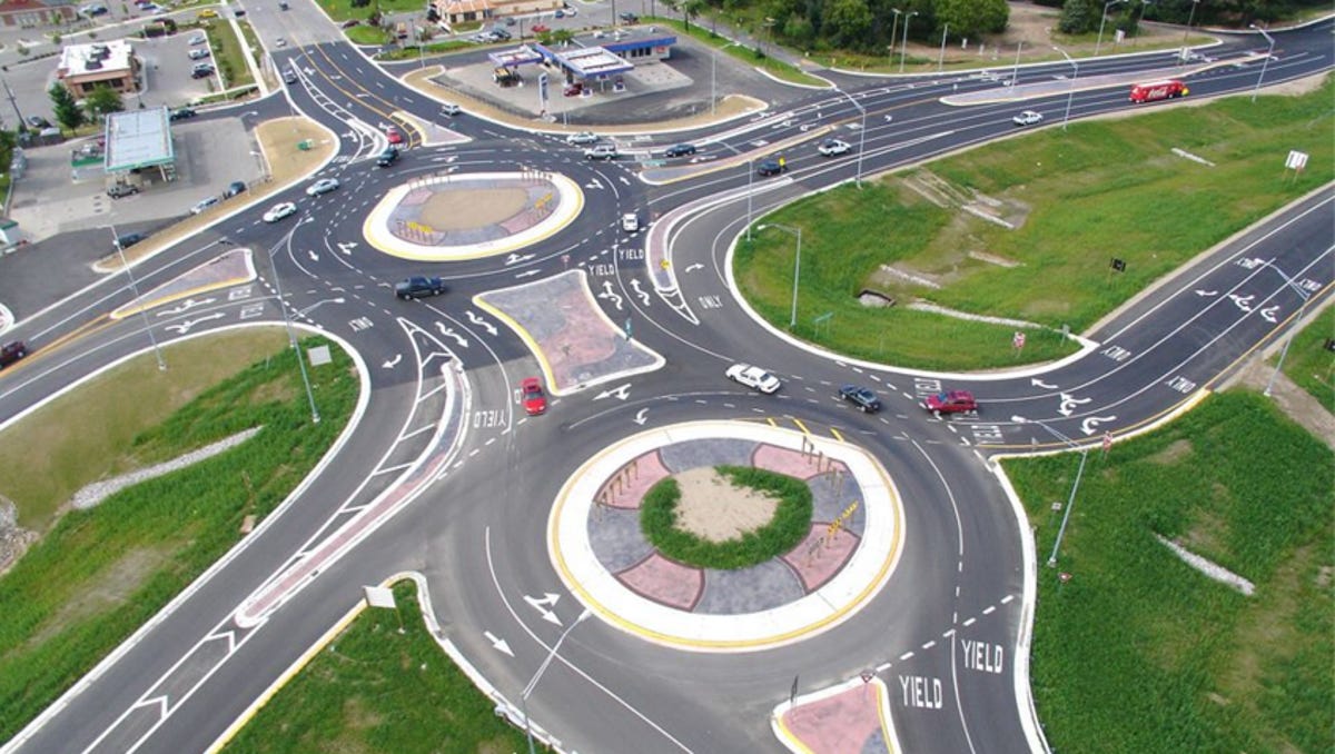
There are a lot out there. I googled "double roundabouts". This is one is in MichiganFair enough, though my concern about it being too complicated still stands then. I also wonder how often you'd see back up in one rotary because of enough people waiting to merge into the other rotary. Do any examples exist in the wild of this type of configuration?
Brattle Loop
Senior Member
- Joined
- Apr 28, 2020
- Messages
- 1,176
- Reaction score
- 2,105
There are a lot out there. I googled "double roundabouts". This is one is in Michigan
I really wonder how that kind of thing would fare when confronted with a multitude of Boston drivers.
The EGE
Senior Member
- Joined
- Jun 29, 2013
- Messages
- 1,902
- Reaction score
- 5,245
Oh, absolutely. But the goal should be to make it better, not worse. This is barely two miles from downtown at a multimodal hub station surrounded by two housing developments, a likely TOD site, a college campus, and a park. It needs to be significantly de-auto-oriented.Isn't pedestrian access already pretty terrible?
This whole area is a cluster. You have a major highway with poor acceleration lanes causing large backups onto Columbia road.
In general, Americans have issues navigating rotaries, throwing in a double rotary could be recipe for disaster.
In general, Americans have issues navigating rotaries, throwing in a double rotary could be recipe for disaster.
Blackbird
Senior Member
- Joined
- Feb 2, 2014
- Messages
- 1,246
- Reaction score
- 1,832
Oh, absolutely. But the goal should be to make it better, not worse. This is barely two miles from downtown at a multimodal hub station surrounded by two housing developments, a likely TOD site, a college campus, and a park. It needs to be significantly de-auto-oriented.
How? I think Charlie’s suggestion was only ever to help traffic. I don’t see an easy way to make the intersection ped friendly beyond a big tunnel or a big bridge…
Highwayguy
Active Member
- Joined
- Apr 1, 2020
- Messages
- 205
- Reaction score
- 546
There are a lot out there. I googled "double roundabouts". This is one is in Michigan
For greenfield development in the Midwest, admittedly not terrible. Though in typical MDOT fashion, no accommodation for non-motorized users.
The problem with doing something like this for K circle is that it would be about four times the size, significantly lengthening the pedestrian detour since MA roundabout design guidance strongly discourages crosswalks across the circulating lanes. Plus at that scale it would function more as a rotary than a roundabout, with all of the former’s general unpleasantness. Not ideal if the purpose is to stich two neighborhoods bisected by a tangle of arterials back together. Additionally, the volumes through those existing intersections are so high that the queues would almost always back up into the circulating lanes of the adjacent rotary, creating the potential for literal gridlock.
Appreciate the sketches/ideas though. This area is a crazy hard one to solve even by Boston standards. DOT and the Bay City developers haven’t been able to come up with anything better yet themselves.
Charlie_mta
Senior Member
- Joined
- Jul 15, 2006
- Messages
- 5,150
- Reaction score
- 7,778
The pedestrian walkways are yellow, and the signalized crosswalks are white. There are probably ways to make this less auto-centric and more pedestrian/bicyclist centric.Very suboptimal from a pedestrian perspective due to the circuitous routing.

Charlie_mta
Senior Member
- Joined
- Jul 15, 2006
- Messages
- 5,150
- Reaction score
- 7,778
Okay, I'm convinced that roundabouts are not suitable for a pedestrian oriented TOD neighborhood. They offer less protection for pedestrians and and bicyclists due to the free-flowing traffic in the roundabout, unrestrained by traffic lights (except for signalized crosswalks). So, I revised my plan to use standard intersections. The roads would be bit wider than shown to include left turn bays and bike lanes. The sidewalks are in yellow and the crosswalks are white. All intersections would be signalized. Morrisey Blvd would be grade-separated and pass underneath the intersection.

Charlie_mta
Senior Member
- Joined
- Jul 15, 2006
- Messages
- 5,150
- Reaction score
- 7,778
If the above plan were designed by today's auto-centric standards, the roads would be wider to accommodate left turn lanes and double lanes. I did at least include bike lanes on most of the roads. Ideally, these roads would be put on a road diet and lanes reduced to look more like the narrower streets in the post above.

Last edited:
stick n move
Superstar
- Joined
- Oct 14, 2009
- Messages
- 13,482
- Reaction score
- 24,530
That last one above is basically how Ive always imagined it. Connect Columbia straight across to Mt Vernon and connect Morrissey to Old Colony either above or below Columbia. Then figure out the ramp situation from there and thats the basic premise. I think some version of this is really the best its gonna get. The left hand turn from Day blvd to old Colony can probably be taken out also and drivers can just loop around Moakley park to get to old Colony.
Last edited:
HenryAlan
Senior Member
- Joined
- Dec 15, 2009
- Messages
- 4,473
- Reaction score
- 5,256
I like the signalized intersection and Morrisey bypass concept, but would it work to have Morrisey below grade? It has enough tidal flooding issues already, this strikes me as unworkable in terms of climate resiliency.
That area is going to get a lot better if the plan to connect the park to Carson Beach goes through and Day Blvd. terminates at Columbia Road by G Street. The two roads are redundant from that point. Then you connect Mt. Vernon with Columbia Road and run Morrissey into Old Colony.
As convenient as Morrissey is for my folks who live in Southie, I don't like the idea of making it more of a speedway - it already entices too many commuters off 93 and through the neighborhood as it is.
As convenient as Morrissey is for my folks who live in Southie, I don't like the idea of making it more of a speedway - it already entices too many commuters off 93 and through the neighborhood as it is.
bobthebuilder
Active Member
- Joined
- Oct 17, 2013
- Messages
- 434
- Reaction score
- 159
There are a lot out there. I googled "double roundabouts". This is one is in Michigan
There's also one in Amherst. Significantly less traffic but it was a definite improvement over the previous intersection.
Charlie_mta
Senior Member
- Joined
- Jul 15, 2006
- Messages
- 5,150
- Reaction score
- 7,778
Morrissey could be on an overpass instead of an underpass, with the rest of the plan staying the same. I prefer highways below grade to reduce visual and noise impacts, but if flooding is an issue here, then above grade is what it should be.I like the signalized intersection and Morrisey bypass concept, but would it work to have Morrisey below grade? It has enough tidal flooding issues already, this strikes me as unworkable in terms of climate resiliency.
BeyondRevenue
Active Member
- Joined
- Mar 13, 2020
- Messages
- 553
- Reaction score
- 1,157
Oh man. No lie... this is the intersection I redesign in my head to fall asleep. Maddening! Really glad you guys are noodling it as well. The TKC Rotary must have shown up in the analog version of 'Crazy Highway Ideas' in 1947 --- and somebody said "Sure! You look like a smart feller. Why not?"
Gotta say, I'm kinda liking elements of the two rotary idea, too, but here's what I'd throw in.
Reconsider: There is no reason to keep a lot of what is here - all built before 93 went in so it's extremely overbuilt. Mega carchitecture to handle vastly more cars than actually use it. Throughput targets need to get cut.
Simplfy: In general there's no reason for expensive over-underpasses if you put the whole area on a strict road diet. If fewer streets come in to the TKC rotary unnecessarily, fewer roads need to get built. Less is more. Slow it down uniformly, smooth it all out. Big picture.
Columbia Road/93: There is room for a tight SPUI - which would eliminate a light or two and make the whole area work better, reducing conflict traffic between there and the rotary.
Day Blvd: Should be knocked down to 2 lanes and removed from the rotary altogether. Day Blvd should move (north to south) from the beach to around the waterside of the old Bayside Expo/Teachers Lot, to join Mt Vernon by Gibson Health. It's a local road, not a friggin' highway. We should treat it that way. Bikes, walkers, quiet, safe. As a set up on the north approach, rework the intersection between Day Blvd at Covington and G.
Columbia/Old Colony on West: Reroute all through traffic to Columbia/Old Colony on West side of Park. There is only a need for one 93 alternate 4-6 lane highway (which is how suburbanites, the main audience, uses it).
Mt Vernon will takes more traffic.
Feeders: Move the rotary adjacent feeders out from close proximity. All the pre-ramping within the 1000' approach is what causes the lion's share of the delay.
I will attempt to sketch this out.
The new TKC Rotary itself: By effective traffic smoothing on approaches, adding labeled slip lanes, reducing roads in and around, the fewer options will pull it all together.
Last edited:
Extending BeyondRevenues's plan to the 2 circle alternative by lining up William Day Blvd and Mt Vernon in a second circle to the east connected by an extension of Columbia Rd. Day and Vernon should pair up well because they are both local roads. Moving Mt Vernon like this should also make it much easier to develop the section of the site nearest to JFK station.

Last edited:
Charlie_mta
Senior Member
- Joined
- Jul 15, 2006
- Messages
- 5,150
- Reaction score
- 7,778
I like it, but it wouldn't fit well with the Dorchester Bay City development:Extending BeyondRevenues's plan to the 2 circle alternative by lining up William Day Blvd and Mt Vernon in a second circle to the east connected by an extension of Columbia Rd. Day and Vernon should pair up well because they are both local roads. Moving Mt Vernon like this should also make it much easier to develop the section of the site nearest to JFK station.
View attachment 19856