You are using an out of date browser. It may not display this or other websites correctly.
You should upgrade or use an alternative browser.
You should upgrade or use an alternative browser.
Winthrop Center | 115 Winthrop Square | Financial District
- Thread starter vanshnookenraggen
- Start date
 IMG_8107
 IMG_8111
- Joined
- Jan 7, 2012
- Messages
- 14,173
- Reaction score
- 23,688
 IMG_1500 by Bos Beeline, on Flickr
 IMG_1525 by Bos Beeline, on Flickr
 IMG_1526 by Bos Beeline, on Flickr
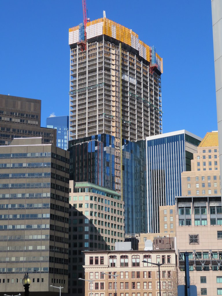 IMG_1561 by Bos Beeline, on Flickr
 IMG_1556 by Bos Beeline, on Flickr
 IMG_1527 by Bos Beeline, on Flickr
 IMG_1585 by Bos Beeline, on Flickr
 IMG_1677 by Bos Beeline, on Flickr
 IMG_1678 by Bos Beeline, on Flickr
 IMG_1682 by Bos Beeline, on Flickr
AndrewOnTheMBTA
Active Member
- Joined
- Mar 12, 2021
- Messages
- 355
- Reaction score
- 776
This is starting to really rise about surrounding buildings. Is it over 40 stories?
This is starting to really rise about surrounding buildings. Is it over 40 stories?
They're working on 47. It's at the 21st floor above the 2 large transition ones. It's easy to match up the floors against the diagram on page 7 here:
Box
Edit: I added this in, with yellow lines on floors 47. Note that 50-52 are part of the crown before the 53rd mech floor at the top, so there are only 2 more "regular" floors after this one.
It's now hanging out with this crew, probably between One International and 100 Federal at floor 47.
Last edited:
The SSP diagram of One Boston Place always bothered me because in reality, the top chevron brace is actually an eccentrically braced frame (the two diagonals do not meet at the top).
Here's the actual diagram's URL in case you want to find any more...
https://skyscraperpage.com/diagrams/?searchID=96082257
The problem is typically the newest picture gets the nod. For One Boston Place the 2nd one is the truest to real life, especially with the proportions of the box on top.
2nd one was also perfect for Preggers.
I'm not sure what the deal is with MT but in that case we're stuck with the one on the right as the main picture.
AndrewOnTheMBTA
Active Member
- Joined
- Mar 12, 2021
- Messages
- 355
- Reaction score
- 776
I dont mean to beat a dead horse, but it's really starting to sink in at this current height, that there won't be a good view of this building from far away -- at a lot of angles. It seems like this location was the perfect opportunity/excuse to build a tower >750 feet, as a lot of its view of views from are blocked by 100 Federal and neighbors. Maybe my mind will change when it is up to around 650' in a few weeks.Here's the actual diagram's URL in case you want to find any more...
https://skyscraperpage.com/diagrams/?searchID=96082257
The problem is typically the newest picture gets the nod. For One Boston Place the 2nd one is the truest to real life, especially with the proportions of the box on top.
View attachment 21144
2nd one was also perfect for Preggers.
View attachment 21145
I'm not sure what the deal is with MT but in that case we're stuck with the one on the right as the main picture.
View attachment 21146
Equilibria
Senior Member
- Joined
- May 6, 2007
- Messages
- 7,229
- Reaction score
- 8,759
I dont mean to beat a dead horse, but it's really starting to sink in at this current height, that there won't be a good view of this building from far away -- at a lot of angles. It seems like this location was the perfect opportunity/excuse to build a tower >750 feet, as a lot of its view of views from are blocked by 100 Federal and neighbors. Maybe my mind will change when it is up to around 650' in a few weeks.
AndrewOnTheMBTA
Active Member
- Joined
- Mar 12, 2021
- Messages
- 355
- Reaction score
- 776
Thank you for sharing. I must have misremembered what the cleared height was for there because of the original Trans National proposal..my mistake!
Blackbird
Senior Member
- Joined
- Feb 2, 2014
- Messages
- 1,246
- Reaction score
- 1,832
That map makes it look like the tower is at or slightly past the 700ft line, thought the downtown streets are so blurry it's hard to be sure.
Why exactly would an extra 25-50ft make a difference at any of these rings? What bad thing could happen if the heights were exceeded? If a plane is flying at 700ft directly over this part of downtown Boston, I'm guessing that there's already a pretty big issue happening..
Equilibria
Senior Member
- Joined
- May 6, 2007
- Messages
- 7,229
- Reaction score
- 8,759
That map makes it look like the tower is at or slightly past the 700ft line, thought the downtown streets are so blurry it's hard to be sure.
Why exactly would an extra 25-50ft make a difference at any of these rings? What bad thing could happen if the heights were exceeded? If a plane is flying at 700ft directly over this part of downtown Boston, I'm guessing that there's already a pretty big issue happening..
I believe that this is literally, with its mechanical, the highest you can go on the site.
What happens if you exceed the surface is that the FAA issues an obstruction finding and your building becomes uninsurable.
I believe that this is literally, with its mechanical, the highest you can go on the site.
What happens if you exceed the surface is that the FAA issues an obstruction finding and your building becomes uninsurable.
I think they left 6' on the table and could have pushed it to 697'. The FAA lines pertain to the heights either above sea level or above the "Boston city base." Even though it's in a 725' zone that partially includes the ground below it, so the whole FAA map is really 25'-50'+ higher than could actually be built at any of those given sites.
Obviously this tower still had to deal with the shadows on the parks issues too. However, I continue to wonder what the cost would be for a second radar system that could allow even more height across much of the city. Wouldn't it be worth it for a a couple developers to chip in if it could add 100'+ to many sites downtown and downtown-adjacent?
Just curious, would this really let buildings go above the existing height limits? I thought it was something to do with "one-engine out" take offs, I could be dreaming that though!
Equilibria
Senior Member
- Joined
- May 6, 2007
- Messages
- 7,229
- Reaction score
- 8,759
Just curious, would this really let buildings go above the existing height limits? I thought it was something to do with "one-engine out" take offs, I could be dreaming that though!
It's layers. The radar does some of it, and the OEO condition does the rest. I think the radar issue was only relevant for Chiofaro's location.
I dont mean to beat a dead horse, but it's really starting to sink in at this current height, that there won't be a good view of this building from far away -- at a lot of angles. It seems like this location was the perfect opportunity/excuse to build a tower >750 feet, as a lot of its view of views from are blocked by 100 Federal and neighbors. Maybe my mind will change when it is up to around 650' in a few weeks.
We should actually be able to expect some pretty good angles from further away. It's the closer ones where this will have more trouble standing out. For instance, from the Eastie piers it will be kind of lost behind other buildings (like MT from many angles) but from the Madonna Shrine and Deer Island a few miles further back it will more clearly be sticking up above the crowd. The further away you get, the more the skyline kind of "flattens" against itself so the tallest buildings (as opposed to the closest buildings) appear the tallest. This will certainly be a stand-out building from the suburbs.
If anything, this will likely satisfy your short term wishes, but also strengthen the long term desire to see something break 700' in downtown (government center through North Station area) and to see something eclipse the Hancock before we're all dead.
Blackbird
Senior Member
- Joined
- Feb 2, 2014
- Messages
- 1,246
- Reaction score
- 1,832
What happens if you exceed the surface is that the FAA issues an obstruction finding and your building becomes uninsurable.
I can't tell if you're being facetious or if you really didn't understand me..
My question is: what goes into creating maps like these? How does it get done? I have a hard time imagining that these perfect, 50ft step-up rings are a precise depiction of the space the FAA really needs versus a general approximation of that space.
People mention "one engine out" scenarios. How are those pathways for compromised aircraft determined or calculated? Is there an assumed starting altitude and angle of descent?
Last edited:
AndrewOnTheMBTA
Active Member
- Joined
- Mar 12, 2021
- Messages
- 355
- Reaction score
- 776
Yes I am in East Boston on the waterfront and that is my biased idea of the skyline. But I also do see a lot of the skyline consensus to be of the downtown waterfront. I will have to make a visit to Orient Heights soon.We should actually be able to expect some pretty good angles from further away. It's the closer ones where this will have more trouble standing out. For instance, from the Eastie piers it will be kind of lost behind other buildings (like MT from many angles) but from the Madonna Shrine and Deer Island a few miles further back it will more clearly be sticking up above the crowd. The further away you get, the more the skyline kind of "flattens" against itself so the tallest buildings (as opposed to the closest buildings) appear the tallest. This will certainly be a stand-out building from the suburbs.
If anything, this will likely satisfy your short term wishes, but also strengthen the long term desire to see something break 700' in downtown (government center through North Station area) and to see something eclipse the Hancock before we're all dead.
From the Common and Public Garden, it looks phenomenal like the MT. I think it's a little hidden coming in from the south on 93 and a bit hidden from north of the city. Once the cladding goes on, the building will be more noticeable, like what happened with MT. Once the weather warms up, I'll have to get more views from bike rides in Cambridge and west of the city.
I can't tell if you're being facetious or if you really didn't understand me..
My question is: what goes into creating maps like these? How does it get done? I have a hard time imagining that these perfect, 50ft step-up rings are a precise depiction of the space the FAA really needs versus a general approximation of that space.
People mention "one engine out" scenarios. How are those pathways for compromised aircraft determined or calculated? Is there an assumed starting altitude and angle of descent?
The reality is there is probably a more detailed map that developers can get access to if necessary. We have the one Massport has publicly made available. There are some quirks in that map fwiw, notably... the height lines on the southern chunk of the map are quite curvy and follow some curious paths which leads me to believe its somewhat political how it was constructed rather than purely technical.
Equilibria
Senior Member
- Joined
- May 6, 2007
- Messages
- 7,229
- Reaction score
- 8,759
I can't tell if you're being facetious or if you really didn't understand me..
My question is: what goes into creating maps like these? How does it get done? I have a hard time imagining that these perfect, 50ft step-up rings are a precise depiction of the space the FAA really needs versus a general approximation of that space.
People mention "one engine out" scenarios. How are those pathways for compromised aircraft determined or calculated? Is there an assumed starting altitude and angle of descent?