You are using an out of date browser. It may not display this or other websites correctly.
You should upgrade or use an alternative browser.
You should upgrade or use an alternative browser.
Acela & Amtrak NEC (HSR BOS-NYP-WAS and branches only)
- Thread starter statler
- Start date
- Joined
- Dec 10, 2011
- Messages
- 5,599
- Reaction score
- 2,719
I was told that the original Nexis4NewJersey image is a Siemens train, so, no, it won't look exactly like that, but I'm sure it will look modern enough.I wonder if the new high-speed trainsets that Amtrak plans to aquire, will look like THIS.
The real question is whether Alstom will sell a Pendolino (tilting) variant.
Jahvon09
Senior Member
- Joined
- Oct 2, 2011
- Messages
- 3,409
- Reaction score
- 849
Yeah, if Amtrak is looking to aquire new & improved high-speed trainsets to replace the existing Acela trains, then it should also look into replacing the existing Hudson River Tunnel.
But as important as it is, this program could turn into another years-long Big-Dig-style project! But even then, the new tunnel is much needed, and it could open the door to the start of the new Gateway Program.
F-Line to Dudley
Senior Member
- Joined
- Nov 2, 2010
- Messages
- 9,970
- Reaction score
- 12,305
Yeah, if Amtrak is looking to aquire new & improved high-speed trainsets to replace the existing Acela trains, then it should also look into replacing the existing Hudson River Tunnel.
But as important as it is, this program could turn into another years-long Big-Dig-style project! But even then, the new tunnel is much needed, and it could open the door to the start of the new Gateway Program.
Separate things. Even if Gateway got funded tomorrow with a hurry-up on EIS'ing, the Acela trainsets hit end-of-life way way before it'll ever be ready. This procurement had to get inked in contract form pretty much by 2016 +/- 1 years just to have something ready by the Acela's expiration date, when the reliability of the existing sets would start becoming problematic. They aren't rebuild candidates, and there are too few of them to plausibly cycle out one or two at a time for overhaul without having consequences for Acela service levels for the duration of the rebuild program. Better to start fresh, and start now.
Buy America's going to saddle this with way too much unnecessary cost overhead. Can't even pin this on bloat for FRA reqs to any significant degree since the eventual specs for these cars will match the FRA's to-be-announced relaxed standards, and it won't be *too* much a Frankenstein creation like the original Acelas were. Alstom's got a preexisting plant in the sense that it has "a" building located in the U.S. that's pumping out railcars right now...but the metal fabrication for these car shells is so different from the subway cars that plant currently does that it pretty much requires building a new factory from-scratch inside the existing building to get any sort of assembly line going. At least when Bombardier was building the Acelas circa 2000 their main Canadian plant was producing active Euro orders for integrated trainsets and they had the pre-existing fabrication equipment to handle the order. This is yet another reinvention-of-wheel for the thin veneer of assembling a 90% foreign-made piece of equipment on American terra firma. Watch this go piggishly over-budget, with underestimates of the Alstom facility and facility support costs being #1 culprit.
Congresscritters and State Legislatorspawn will never learn.
- Joined
- Dec 10, 2011
- Messages
- 5,599
- Reaction score
- 2,719
Progressive Railroading has the first confirmation that the Amtrak BOD actually did approve Alstom as Sen. Schumer predicted:
OK so thus far, Buy America has only been relaxed on the pre-production/prototype trainset (which Alstom is free to build in Europe for Amtrak's approval testing).USA: On September 22 the Amtrak board approved the start of exclusive negotiations with Alstom for a contract to supply the next generation of trains for the Northeast Corridor...
The contract for around 28 trainsets with an estimated value of $2·5bn is expected to be finalised by the end of the year. Final approval of federal funding from the Railroad Rehabilitation & Improvement Financing programme is also required.
‘Should this contract materialise, this would be a great recognition of Alstom's expertise in high speed and we will be honoured to serve Amtrak for this ambitious project’, said Alstom Transport President Henri Poupart-Lafarge.
Technical details of the proposed trains are to be released at a later stage[...]Amtrak required a maximum speed of 257 km/h (160 mile/h) for use on existing NEC infrastructure, with options for 300 km/h or 350 km/h, while CHSRA was seeking 320 km/h trainsets for use on a new line.
In November 2014 the Federal Railroad Administration approved a waiver on Buy America procurement rules covering two pre-series high speed trainsets for each of Amtrak and CHSRA.
Jahvon09
Senior Member
- Joined
- Oct 2, 2011
- Messages
- 3,409
- Reaction score
- 849
Separate things. Even if Gateway got funded tomorrow with a hurry-up on EIS'ing, the Acela trainsets hit end-of-life way way before it'll ever be ready. This procurement had to get inked in contract form pretty much by 2016 +/- 1 years just to have something ready by the Acela's expiration date, when the reliability of the existing sets would start becoming problematic. They aren't rebuild candidates, and there are too few of them to plausibly cycle out one or two at a time for overhaul without having consequences for Acela service levels for the duration of the rebuild program. Better to start fresh, and start now.
Buy America's going to saddle this with way too much unnecessary cost overhead. Can't even pin this on bloat for FRA reqs to any significant degree since the eventual specs for these cars will match the FRA's to-be-announced relaxed standards, and it won't be *too* much a Frankenstein creation like the original Acelas were. Alstom's got a preexisting plant in the sense that it has "a" building located in the U.S. that's pumping out railcars right now...but the metal fabrication for these car shells is so different from the subway cars that plant currently does that it pretty much requires building a new factory from-scratch inside the existing building to get any sort of assembly line going. At least when Bombardier was building the Acelas circa 2000 their main Canadian plant was producing active Euro orders for integrated trainsets and they had the pre-existing fabrication equipment to handle the order. This is yet another reinvention-of-wheel for the thin veneer of assembling a 90% foreign-made piece of equipment on American terra firma. Watch this go piggishly over-budget, with underestimates of the Alstom facility and facility support costs being #1 culprit.
Congresscritters and State Legislatorspawn will never learn.
Yeah, and the sad part of this is that the planned newer trains high-speed will not be running any faster than the existing Acela trains in use today.
I think that Alstom is the one who is also rebuilding some of the Type 7 trolleys for the MBTA's Green Line.
- Joined
- Dec 10, 2011
- Messages
- 5,599
- Reaction score
- 2,719
Rail-industry periodicals are reporting that Amtrak has not made its final HSR trainset choice, but two bidders remain (contrary to what's been reported here).
Amtrak [source] says that while Alstom is a bidder for the contract, the procurement process is still open and that two pre-qualified suppliers are still in the running for the contract.
F-Line to Dudley
Senior Member
- Joined
- Nov 2, 2010
- Messages
- 9,970
- Reaction score
- 12,305
Yeah, and the sad part of this is that the planned newer trains high-speed will not be running any faster than the existing Acela trains in use today.
I think that Alstom is the one who is also rebuilding some of the Type 7 trolleys for the MBTA's Green Line.
Well, the current Acelas will be running 165 MPH in New Jersey; Kingston-Cranston, RI; and Attleboro-Sharon as soon as the FRA approves the Class 8 uprates in New Jersey and that forces the schedule change that puts the RI and MA segments online. That's only weeks to a few months away...certainly no later than Spring thaw from being a real thing. 165 MPH is 265 km/h. There's only 11 HSR systems in the world currently running today that have a higher top speed than that, and the world leader tops out at 320 km/h (198 MPH) not too great a degree higher.
So, the equipment is definitely capable of the best the world has to offer, and has been since 1999. Acela 2 doesn't need a radical performance redesign to be future-proofed for higher speeds; it just needs to shed some of the excess weight and get away from Bombardier's problematic design compromises so it's a lot more efficient to run. The unsolvable problem is simply that the NEC doesn't offer up enough miles of tangent track to perform up to the equipment's capabilities for long enough stretches. And can't be bypassed on nearly enough new miles of straight segments without missing a few too many big built-up cities. They're finding that out as they pare down the 2040 Vision alternatives. It's always going to be 'mongrel' HSR, even at full state-of-repair and every cent's worth of upgrade investment it deserves. But that's just how the East Coast is constructed. The density filled in chaotically over 2-1/2 centuries...not planned on a grid like all the ex-Frontier west of the Appalacians were. So even when we get to "Acela 5" and full state-of-repair and the full-built 2040 vision...it's still not going to be full end-to-end Euro-class having lots of 165 MPH territory taking advantage of the equipment's capabilities. But that's OK. Gotta go where the people are, and that's how the whole East Coast is laid out.
- Joined
- Dec 10, 2011
- Messages
- 5,599
- Reaction score
- 2,719
^ Amen. It is worth remembering that the TGV launched at 170mph Paris-Lyon and immediately started pushing the airlines out of the market. HSR doesn't need to be fastest in the world. It only needs to be fastest in a given city-pair.
Acela is a success in the WAS-NYC market, giving Amtrak a cash machine and halving the airline's share. Taking it to the next level is a mix of speed and capacity bumps not leaps.
Acela is a success in the WAS-NYC market, giving Amtrak a cash machine and halving the airline's share. Taking it to the next level is a mix of speed and capacity bumps not leaps.
CantabAmager
Active Member
- Joined
- Dec 10, 2014
- Messages
- 216
- Reaction score
- 0
What's the realistic speed ceiling for the Shore Line in Connecticut? I get New Haven-NYC is always going to be bit cramped and the bends/bridges in CT aren't optimal for proper true-blue HSR, but surely there's got to be some wiggle room once the river crossings are upgraded.
Here's what I figure is possible:
https://www.google.com/maps/d/edit?mid=zkzO6ChGpVHo.kB8a7uKwI6-Y&usp=sharing
Much of west of New Haven can be brought up to 1 mi rad which translates to 110-120mph, with the exception of around Glenbrook and Norwalk. This requires bypasses of Port Chester and Bridgeport in particular.
For east of New Haven, anything orange, green or blue is 160mph or greater. Blue is good up to 200mph.
Last edited:
F-Line to Dudley
Senior Member
- Joined
- Nov 2, 2010
- Messages
- 9,970
- Reaction score
- 12,305
What's the realistic speed ceiling for the Shore Line in Connecticut? I get New Haven-NYC is always going to be bit cramped and the bends/bridges in CT aren't optimal for proper true-blue HSR, but surely there's got to be some wiggle room once the river crossings are upgraded.
Not much higher than it is now. From Rich Green's old Connecticut track map, here's what I've got for track speeds, New Rochelle to Attleboro station. From 2007, but nothing significant has changed. Individual speed restrictions within a track speed zone are indented; those are the ones only a few hundred feet long around modest curves or local station approaches (i.e. small enough to not force a change in speed limit outside of 1 or 2 signal blocks). I omitted the ones that were only 5-10 MPH variances because in an Amtrak-length schedule those don't even dent the schedule padding margin for error and are 100% non-entities in any NEC improvements conversation.
Don't know what the individual changes in speed limits are inbound of Sharon station, but that's only 18 miles to Boston where the 128 station stop and SW Corridor/terminal district come into play. All I know is it's not slow until you approach Back Bay, and other than *maybe* a few MPH from 128 to Forest Hills when they add back Track 3 Canton-Readville and Track 4 Readville-Forest Hills there's no potential for making it any faster. Certainly nothing worth more than 1-2 minutes to the schedule.
New Haven Line
- Shell Interlocking + New Rochelle station -- 70 MPH from Grand Central side of junction, 45 MPH from Penn side of junction
- New Rochelle to Harrison -- 90 MPH
- Harrison to Port Chester -- 75 MPH
- Port Chester station to CT state line -- 45 MPH (individual curve)
- CT state line to Cos Cob bridge -- 70 MPH
- Cos Cob bridge -- 50 MPH
- Cos Cob bridge to Stamford -- 75 MPH
- Stamford station terminal district -- 50 MPH
- Stamford terminal district to New Caanan Line split -- 60 MPH
- NC split to East Norwalk -- 70 MPH
- Walk Bridge -- 45 MPH (may be less today)
- East Norwalk to Bridgeport station approach -- 75 MPH
- Saga Bridge -- 40 MPH
- Bridgeport curve to Peck Bridge -- 45 MPH (note: no speed restrictions on 1998-construction Peck Bridge)
- mid- Bridgeport curve -- 30 MPH
- Peck Bridge to Devon Bridge -- 75 MPH
- Devon Bridge -- 40 MPH
- Devon Bridge + adjacent Waterbury Line split -- 60 MPH
- Waterbury split to New Haven -- 75 MPH
- Milford station approach -- 60 MPH (4 tracks temporarily drop to 3)
- New Haven terminal district to State St. station -- 30 MPH
Shoreline
- State St. to Springfield Line split -- 50 MPH
- Springfield split to Clifton St. tunnel -- 70 MPH
- Cedar Hill freight yard curve -- 60 MPH
- Clifton tunnel to Branford station -- 80 MPH
- Branford station to MP 86/Leete's Island -- 120 MPH
- MP 86 to MP 87 -- 95 MPH
- MP 87 to Guilford station -- 115 MPH
- Guilford station to Madison station -- 125 MPH
- Madison station to Westbrook station -- 115 MPH
- Westbrook station to Old Saybrook quad-track -- 90 MPH
- Old Saybrook quad-track + station to South Lyme/MP 110 -- 110 MPH
- Connecticut River Bridge -- 30 MPH
- MP 110 to Niantic River Bridge -- 90 MPH
- MP 112 -- 70 MPH curve
- Niantic River Bridge to Shaw's Cove Bridge -- 75 MPH (no restrictions on 2012-construction Niantic or 1984-construction Shaw's Cove bridges)
- (Miner Ln. grade crossing)
- Shaw's Cove to New London Station -- 25 MPH
- (Bank St. Connector, State St., Winthrop Blvd. grade crossings)
- New London Station to Thames River Bridge -- 45 MPH (no restrictions on 2008-rebuilt Thames bridge)
- Thames River to Old Groton Industrial Track junction (3-track territory) -- 65 MPH
- Groton Ind. Track to Mystic station -- 90 MPH (no restrictions on 1984-construction Mystic River Bridge)
- MP 129 -- 70 MPH (single curve)
- (School St. grade crossing)
- Mystic bridge + Mystic station to Walkers Dock grade crossing -- 75 MPH
- Mystic station + grade crossing -- 60 MPH (sharp single curve)
- (Wamphassuc Point Rd. grade crossing)
- Walkers Dock to Bradford, RI -- 90 MPH
- (3 grade crossings)
- Bradford to Shannock/MP 154 -- 105 MPH
- MP 152/Carolina -- 85 MPH (single curve)
- MP 154 to East Greenwich/MP 172 -- 150 MPH (pending 165 MPH)
- MP 160 -- 130 MPH (single curve)
- MP 170 -- 130 MPH (single curve)
- East Greenwich to Gannon Chemical freight siding/MP 174 -- 115 MPH
- MP 174 to Port of Providence Industrial Track -- 150 MPH (pending 165 MPH)
- PoP Ind. to MP 182 -- 100 MPH
- MP 182 to MA state line -- 70 MPH
- MP 182 -- 55 MPH (single curve)
- Atwells interlocking (junction with P&W FRIP track) -- 60 MPH
- Providence station approach -- 30 MPH
- MA state line to East Junction -- 125 MPH
- East Junction to Sharon curve -- 150 MPH (pending 165 MPH)
Now...New Haven Line looks dog-slow with all those mid-70's. And the Shoreline in CT looks better than it really is with those 90's and low-100's. But that has very little to do with speed-killing curves. The New Haven Line is significantly less curvy than the Shoreline. The problem is simply congestion. You can tart of the two center express tracks all you want with superelevation and re-spacing for tilt so the geometry supports higher speeds...but just as many Metro North trains run express with wide stop spacing on the inner tracks as run local with dense stop spacing on the outer tracks. Enough so that there's only so many crossovers you can throw in there to weave around them before the passing maneuvers themselves set the speed ceiling.
The Shoreline just has Shore Line East and RIDOT-to-be. There will never be more than one middling-schedule commuter rail co-tenant anywhere from State St. to Wickford Jct. So not only do the commuter trains not impose the upper speed limit out of their sheer numbers and close spacing on all tracks, but blasting by at full speed on a crossover is much easier when both the commuter trains and their station stops are so much more widely spaced. Metro North would be considerably faster than the Shoreline if it were blessed with SLE's schedule. Strictly in terms of track geometry, the Shoreline is a way uglier piece of engineering. And the fact that it doesn't serve any particularly large cities (Old Saybrook and New London are not exactly must-haves for true HSR as long as the Regionals presence stays robust) makes it the hands-down better bypass candidate.
So in MNRR territory you're always single-file behind some commuter train with not nearly as many opportunities to cross over and pass as you would...say, in the 3+ tracks of SEPTA and MARC territory. Or even NJ Transit for that matter, since not even the crush-load Trenton Line with its double-digit car trains can hold a candle to the sheer density of New Haven Line service levels. That's a 90 MPH uppermost limit, but since the MNRR trains that travel the express tracks are turning in and out the whole way to make their wider-spaced stops the EMU's generally don't have enough acceleration room to hit their full 90 MPH rating for more than small stretches...much less hit the theoretical max of the straighter track geometry in ideal (i.e. if there were no trains ahead) conditions. This will never change. You can nip and tuck on just a couple tough curves and just a couple tilt zones to save a couple minutes, but it's the continent's densest-service commuter rail line all the same. And you have to engage it if you want to hit the population centers.
You don't have room for 5 or 6 tracks anywhere except for a small stretch north of the Shell interlocking between New Rochelle and Larchmont. So 4 tracks now, 4 tracks forever. 5-6 tracks at Shell combined with a grade separation of the junction would help a ton to sort the merging traffic from Grand Central and Penn, but doesn't help for passing upstream. It mainly serves to whack that painful 45 MPH restriction coming off the Hell Gate Line so those trains can keep doing 100 MPH from Pelham Bay all the way into New Rochelle station.
The only other significant curve that can be eliminated is the one between Stamford and Noroton Heights where if the I-95 cavity were widened out to the abutter property lines with retaining walls you might be able to fit it alongside (or do 2 bypass tracks along 95 and 4 local tracks on the old alignment) and simply have the New Caanan line absorb the 4000 ft. due-northward dive of the old alignment) to a new junction. Most of the other mini-bypasses that look like they could be done just from scrolling on Google Maps need to take into account: how much speed are you going to gain from the straightening when commuter traffic is still the same?
I think in the end you learn to love the New Haven Line for what it is, and focus on running up the score with more 165 MPH territory in the Jersey swamp, Delaware, the Eastern CT-Providence bypass, mini-bypasses of a mile here/there, altering curves a couple degrees where room allows, and superelevating curves for tilt where that matters. Squeeze every second you can north of New Haven and south of New Rochelle so the savings are banked in for coasting through Fairfield County. It's not like the LIRR Main Line + a cross-Sound tunnel is any less a congestion pickle. It's arguably more daunting because it starts with fewer tracks and has many more branchline mouths to feed. And as for the Westchester bypass that misses too many population centers...it's as engineering-improbable with the terrain along I-84 as it is impossible to get the dense abutters to support.
F-Line to Dudley
Senior Member
- Joined
- Nov 2, 2010
- Messages
- 9,970
- Reaction score
- 12,305
Here's what I figure is possible:
https://www.google.com/maps/d/edit?mid=zkzO6ChGpVHo.kB8a7uKwI6-Y&usp=sharing
Much of west of New Haven can be brought up to 1 mi rad which translates to 110-120mph, with the exception of around Glenbrook and Norwalk. This requires bypasses of Port Chester and Bridgeport in particular.
For east of New Haven, anything orange, green or blue is 160mph or greater. Blue is good up to 200mph.
That's not the whole story because you're only looking at track geometry and speed within track geometry. It's train spacing density that sets the upper theoretical limit. Every time an Amtrak has to hop over a Metro North by changing tracks it's a small penalty, because with the extremely tight signaling density on the New Haven Line these aren't the big drawn-out sweeping HSR crossover interlockings like you see from New Haven to Boston or in the Jersey and Delaware swamps. These have to get their business over with inside a tight block. Commuter rail service density on BOTH the inner and outer tracks is so great the way MNRR service is layered with pure-local, semi-local, semi-express, and express patterns that the number of overtake mini-penalties required to thread through and hit geometric track speeds on any stretches between overtakes has you quickly converging on the same 75-90 MPH average speed as today.
In other words, the harder you fight the speeds the more ground you cede with overtake penalties. Until you end up at par. It would be nice if the Long Island bypass were much better, but LIRR's just as scary crowded and has exactly the same diminishing returns the higher you try to push the Amtrak speed differential over commuter rail speed via overtakes. Damned if you do, damned if you don't. This is why running up the score with schedule savings in the territory south-of-NYC and east-of-NHV is what makes the schedule in the end. SW Connecticut and/or Long Island are always going to be coasting speed.
So, when making a value judgment here on what purely geometric improvements to spend on the New Haven Line it has to target the ones that boost Metro North commuter speeds in equal proportion. i.e. It matters way more to target those 70 MPH segments that match up with open-running segments between stations where an M8 consist that currently only hits 70 coming off a restricted curve could instead hit 90 between stops...and to get all vehicles going 90. It's wasted effort to go too far trying to push Amtrak-only into triple digits; MNRR's only going to be averaging 60's or low-70's when station approaches and frequent accel/decel gets factored into the traffic they take up on all 4 tracks. There's little if any gains to be had taking something currently hovering a little bit sub-80 above 90 MPH, or going too far overboard on station approaches taking property or bypassing a downtown. Those curve improvements don't zip along Metro North any faster on any of the tracks, and if it can't zip along Metro North any faster it can't zip along Amtrak any faster.
- For example...that Port Chester bypass is a total nonstarter. The curvature along the I-95 alignment isn't that different and you don't gain very much running up the score there with a triple-digit Amtrak bypass of the commuter rail stop when it's only going to leapfrog at best 1 or 2 MNRR trains. All it accomplishes for the $$$ is getting you a minute or two faster to the next 70 MPH single-file line on the express tracks. It probably ends up a zero on schedule improvements to New Haven. Since Port Chester isn't saddled with any localized curve restrictions that slow MNRR down, it's very low on the places you want to target for a straightening.
- Noroton Heights bypass might have some mutual speed-up potential. Not so much because the current exaggerated curves are all that speed-restrictred (the New Caanan junction the curve is actually faster than the straightaway into Stamford because of proximity to the terminal yard). But by sticking to 95 and giving the old alignment over to New Caanan you move the junction into the Stamford terminal district where all the yard tracks sort the junction with more passing opportunities and it's all tucked neatly inside the Stamford station approach. Everybody has more opportunity to rev up to speed out to Noroton, which might be worth +10 MPH for all parties and a more fluid overtake. I'd earmark that one as a contender, especially because the 95 cut can be reworked without property acquisition.
- There is no freaking way you're skipping downtown Bridgeport or altering that alignment. None. Most populous city in CT; third-largest in New England after Boston and Worcester. That's an HSR stop on nearly every trip, so the 45 MPH restriction crammed into a single mile of downtown doesn't matter a single second of savings for 75% of the schedules you'd ever run. The 2040 plan revisions are all backing away from the downtown bypasses the initial alternatives had because of the demand loss, and this is one of the prime examples why.
- You aren't going to be able to build those I-95 hugging bypasses of the Shoreline just east of New Haven in Clinton and Madison. Zoom in on 95 and count the number of trap rock outcrops framing the highway. This is why the add-a-lane proposal for expanding the highway from 4 to 6 lanes clocks in at over $1B for little more than 15 miles of work. There is a metric asston of blasting--and blasting mitigation--required. That is going to be the killer for the 2040 alternative for shifting portions of the Shoreline a little bit inland to get off the bridges. 95 is cut through one of the hardest rock seams in the state. They aren't tall outcrops, but they are hard suckers and make grading anything linear and level very difficult because of the choppiness of the terrain. The area was unpopulated in 1954 when they went hog wild with war surplus explosives in constructing 95, but I don't think that quantity of required dynamite is going to play well with so many abutting wood residential structures or the copious wetlands.
- Then there's the wetlands themselves. Tidal marshes galore, and even if you could mitigate them properly for construction the sea level rise considerations throw another monkey wrench into the works. Those marshes are what absorbs the storm surges so the shorefront developments don't get a long-duration inundation. Bisecting them with a roadbed that may only have scattered culverts for passing water under has consequences for the 'sponge' effect they serve, and do you really want frequent washouts on those tracks? Different climatological world we're living in now; that hurts the chances of big shoreline civil engineering projects disproportionately. Another reason why Shoreline is highly unlikely to make the 2040 cut.
- That wooded area you're cutting through in Waterford to try to bypass New London to the west is another hard-ass rock outcrop. East of Niantic realignment...another smaller outcrop. Check terrain view. There's a reason why the railbed is where it is through here. South bypass through Waterford is conservation land...no dice. Also, keep in mind that Miner Ln. grade crossing is why the 75 MPH speed limit in this stretch isn't raised to 90 when the track goes tangent. The town wants this one gone because it was the scene of a horrifying Acela-on-car accident a decade ago that killed an entire family, and an inexpensive access driveway to the couple industrial tenants south of the crossing is all that's needed. For whatever reason ConnDOT has never revisited the subject.
- Also...holy fuck, the destruction to New London's primary residential neighborhoods! That's as sadistic as it is unnecessary.
- Stonington north bypass: check terrain view...rock outcrops. Railbed was laid where it is for good geological reason.
- Stonington south bypass: wildlife preserve...no-go. Tidal marshes in a sea level rise era on both sides of the state line...no-go. Pawcatuck River is a navigable waterway south of downtown; you're adding +1 more movable bridges to the Shoreline if you try to cross by the airport. There's 0% chance that one will appear on any Amtrak DEIR for the Shoreline realignment alternative.
Nexis4jersey
Active Member
- Joined
- Mar 2, 2012
- Messages
- 803
- Reaction score
- 244
Some recent videos from Jersey Mike
Amtrak Train 172 - Old Saybrook to New London Rear View
[youtube]TXyQnw3-55M[/youtube]
Amtrak Train 172 - New London to Kingston Rear View
[youtube]0DqAWcTi43w[/youtube]
Amtrak Train 172 - Kingston to Providence Rear View
[youtube]5eblahYmWDA[/youtube]
Amtrak Train 172 -Providence to Route 128 Rear View
[youtube]YrwH0KdqO10[/youtube]
Amtrak Train 172 Route 128 to Boston Back Bay
[youtube]GRwUg2LrPvg[/youtube]
whighlander
Senior Member
- Joined
- Aug 14, 2006
- Messages
- 7,812
- Reaction score
- 647
Excellent adventure!!!
The only thing better would have been a view from out of the cab up front
The only thing better would have been a view from out of the cab up front
F-Line to Dudley
Senior Member
- Joined
- Nov 2, 2010
- Messages
- 9,970
- Reaction score
- 12,305
http://www.burlingtonfreepress.com/story/news/2015/10/05/amtrak-derails-northfield/73377120/
Whoa. Today's southbound Vermonter took a spill in Northfield, VT just outside of Montpelier.
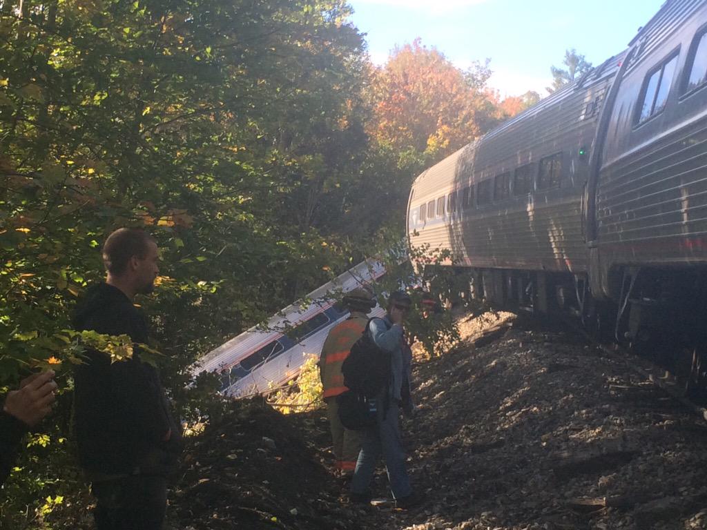
Rockslide covered the tracks from an embankment destabilized by all the wet weather. Locomotive hit the rockslide and sent it and the first car tumbling down the hillside. Second car spun around but stayed at track level, cars 3-5 either stayed on-track or only partially derailed.


4 confirmed injuries out of 98 passengers and 4 crewmembers onboard, none believed life-threatening. First car on the southbound is usually closed until it hits Springfield and starts taking on regular Regional/Shuttle ticketholders, so it was probably only the crew that got a pants-crapping up and close personal view of the very bottom of the ditch.
EDIT: . . .
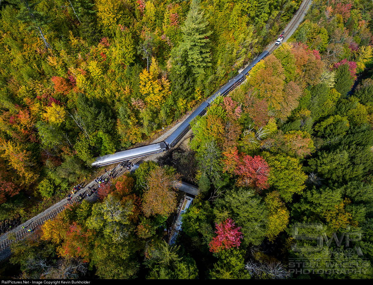
That's a long way down.
Whoa. Today's southbound Vermonter took a spill in Northfield, VT just outside of Montpelier.
Rockslide covered the tracks from an embankment destabilized by all the wet weather. Locomotive hit the rockslide and sent it and the first car tumbling down the hillside. Second car spun around but stayed at track level, cars 3-5 either stayed on-track or only partially derailed.
4 confirmed injuries out of 98 passengers and 4 crewmembers onboard, none believed life-threatening. First car on the southbound is usually closed until it hits Springfield and starts taking on regular Regional/Shuttle ticketholders, so it was probably only the crew that got a pants-crapping up and close personal view of the very bottom of the ditch.
EDIT: . . .
That's a long way down.
Last edited:
- Joined
- Jan 22, 2012
- Messages
- 5,078
- Reaction score
- 1,662
Amazing no one was killed.
The EGE
Senior Member
- Joined
- Jun 29, 2013
- Messages
- 1,902
- Reaction score
- 5,245
The Montrealer took a similar spill a bit after a bridge completely washed out further north in Vermont in 1984, that time with several dead. Would have been dozens dead, except for sheer luck. Area hospitals were at shift change (=double staff), there were 2400 National Guard members plus helicopters and a tank retriever nearby, and a large mobile crane able to be moved quickly just ten miles away. That got a lot of badly injured people out of crushed cars and into beds real quick. It was the first wreck with Amfleets, and it was out of that Amtrak made some changes to the cars to improve survivability in wrecks. May well have helped here.