Acela & Amtrak NEC (HSR BOS-NYP-WAS and branches only)

Why would anyone of sound mind attempt that when level terrain nets equal travel times and the ability to fork to Worcester and Providence.
Who owns all the I-384 ROW? That's my hangup: NIMBY/Encroachment. Won't the same forces that stopped I-384 stop anything else?
 
I think this is going to whittle down to what we knew all along:

-- The route of the NEC south of New Haven is unimprovable for the destinations it serves. Therefore the focus is going to have to be on maxing it out for all the capacity and incremental gains it can take. It will always be 'mongrel HSR', but that isn't a bad thing when D.C., Baltimore, Wilmington, Philadelphia, Trenton, Newark, New York, Stamford, Bridgeport, and New Haven are servable on one schedule. No airline can match that.

-- The Springfield Line is an underutilized asset that can be improved to triple-digit speeds while serving more huge destinations.

-- The Willimantic-Plainfield cleanroomed HSR bypass probably is feasible without opposition, and the remaining NYNE ROW (active Manchester-Hartford, landbanked Moosup-Cranston) is triple-digit ready. The potential highway bootstrap if built in tandem can significantly defray the cost.

-- Both Worcester-Boston and Providence-Boston are reachable with forks off Plainfield, Worcester by improving the active and straight P&W mainline.

-- The East Side Tunnel in Providence and HSR rehabilitation of the East Junction Branch would bypass all of the freight and commuter rail congestion in Pawtucket, Central Falls, and South Attleboro and open up another 5 miles of 150 MPH territory. That is probably doable, and would keep the co-mingling of everything in Providence to just 2 miles of track in Cranston and Olneyville. This is probably doable.


Cross-Sound tunnels, Westchester bypass will be the last cuts from the plan. They will get studied with full due diligence, and they will fall apart for exactly the reasons we think they will.
 
Who owns all the I-384 ROW? That's my hangup: NIMBY/Encroachment. Won't the same forces that stopped I-384 stop anything else?

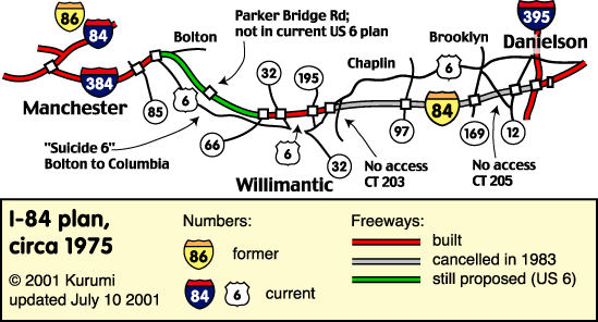
No. The last I-384 routing and attempt at fed funding in 2003 gained approval from the locals at long last. It was a 4-lane highway with avg. 1000 ft. greenway median for environmental protection and sound deadening taking a north-of-Hop River routing with no exits except possibly one in Andover near Routes 6 and CT87 (undecided). Most of it is woods that are either state-owned conservation property, bought or eminent domained eons ago for I-84 by the state, or are one of those quirky 18th century land-deed things where some old Yankee family has owned a patch of re-forested farmland for 200 years and gets some grandfathered tax break if they just don't build on it. Very few private property takings, which was the whole point at gaining approval. There is a whole lot of nothing near the Hop River.

It got spiked by the Army Corps who said it would only endorse the south-of-Hop River routing that required the most houses to be bulldozed of any of the alternatives under consideration. Gave environmental protection reasons, but no compelling justification for them. It was most likely a South Coast Rail-esque political power play to force them to do business on the Army Corp's terms so the right people got the busywork. Fast-track fed funding application was withdrawn due to the impasse, and that to-date has been the end of it.

Willimantic-Plainfield was never all that controversial, even 50 years ago. Pretty much still this:

i84e-plan.gif


None of that, of course, matters until you have a contiguous highway to Willimantic.


They can dust off this Willimantic plan again and if the Army Corps doesn't play politics again they probably get approval on the route the locals agreed to. Building the rail line in the median may be an extra feather in the cap because while it will claim a few feet of greenway the reduction in truck traffic from Worcester-Hartford double-stack intermodal freight and commuter rail Hartford-New London will be an aggregate net-gain for pollution and traffic reduction.

Wouldn't have to wait for the other pieces of the HSR bypass to make optimal use of it either.
-- Connect to Willimantic and NECR's mainline offers direct access to New London and Mohegan Sun for diesel commuter rail out of Hartford.
-- Freight already moves between P&W and NECR Worcester-Plainfield-Willimantic on the P&W mainline and Willimantic Secondary. Hartford intermodal can begin immediately, and P&W can take its dailies to New Haven off the crowded Shoreline.
-- Can operate diesel before electrifying, and Class 4/80 MPH track standards before upgrading the maintenance class to the Class 8/150 MPH the ROW would support for HSR. On all-diesel a Hartford-Willimantic-Plainfield-Worcester train probably would not beat an Inland through Springfield, but might be adequate enough for commuter/regional rail between the cities.
-- Northeast Regionals will have dual-mode locomotives at their disposal in probably another 8-10 years when Amtrak replaces its 3rd rail shoe Empire fleet with pantograph duals equally capable on- and off-wire. You will quite likely see these things on the Virginia and Springfield Regionals. So 125 MPH trains can cover the diesel gaps if you're doing slow-rolling upgrades. And eventually if New Haven-Willimantic and Worcester-Boston are up-to-snuff under wires the diesel gap through the slow legacy track will begin to handily beat the Springfield Inlands and become the preferred Hartford/Worcester-serving route from D.C. to Boston.
-- Plainfield-Providence can be built before the Willimantic-Plainfield highway + HSR extension if you likewise don't mind putting with the slow-speed gap on the Willimantic Sec. for a few years. This can open up Providence sooner to Hartford-Providence regional rail and 125 MPH Northeast Regionals that beat the Shoreline's slow-ass total travel time between New Haven and Providence.
-- Complete route when you fill in the last clean-roomed highway + HSR gap and get off the Willimantic Sec.
-- Speed increases on P&W to get a more even 90 MPH (diesel). Some grade crossing eliminations needed (Webster and Oxford in MA, especially), maybe some minor curve-straightening. Electrification expensive because 23'1" under-bridge clearance needed for double-stack freights to pass under wires. But unless the future Acelas are going to need this Worcester fork in large numbers you can get by with a dual-mode NE Regional doing 90 in the diesel gap between Plainfield and Worcester and 110-125 everywhere else for a lot of years before there's any compelling urgency to upgrade here.
 
Last edited:
The last I-384 routing and attempt at fed funding in 2003 gained approval from the locals at long last. It was a 4-lane highway with avg. 1000 ft. greenway median for environmental protection and sound deadening taking a north-of-Hop River routing with no exits except possibly one in Andover near Routes 6 and CT87 (undecided)....Willimantic-Plainfield was never all that controversial, even 50 years ago. Pretty much still this:

i84e-plan.gif

None of that, of course, matters until you have a contiguous highway to Willimantic....Building the rail line in the median may be an extra feather in the cap because while it will claim a few feet of greenway the reduction in truck traffic from Worcester-Hartford double-stack intermodal freight and commuter rail Hartford-New London will be an aggregate net-gain for pollution and traffic reduction.
Thanks for the details! That's pretty compelling. With one or no exits, it seems ideal as a dynamically-tolled highway so that they can promise the locals that it'll never need to be more than 2 highway lanes, and build both road and rail as a single project, and serving 3 modes (tollway, HSR, & freight) makes it much more affordable.
-- Freight already moves between P&W and NECR Worcester-Plainfield-Willimantic on the P&W mainline and Willimantic Secondary. Hartford intermodal can begin immediately, and P&W can take its dailies to New Haven off the crowded Shoreline.
How far does the P&W train go? (how many bridge-closings can be reclaimed for passenger service if this freight is diverted...I'd think deleting this one, slow freight might get you 2 pax trains worth of slots)
On all-diesel a Hartford-Willimantic-Plainfield-Worcester train probably would not beat an Inland through Springfield,
It wouldn't? Are you talking travel time or economics? While elsewhere we've discussed that I wouldn't bypass Springfield on Boston-Montreal service, I *would* bypass Springfield on Boston-Worcester-Hartford-NYP service, and let Springfield drive to Hartford if they're in a hurry to go south, same way Worcester drives to Providence today to catch the Acela. 110mph diesels would be huge winners anyplace you ran them, I'd think.
 
Last edited:
Thanks for the details! That's pretty compelling. With one or no exits, it seems ideal as a dynamically-tolled highway so that they can promise the locals that it'll never need to be more than 2 highway lanes, and build both road and rail as a single project, and serving 3 modes (tollway, HSR, & freight) makes it much more affordable.

There's no exits planned because there's nothing out there between Bolton Notch and Route 66 in Willimantic (start of the 1970's highway segment) and at 65 MPH with none of the curves of "Suicide 6" it's a really fast drive between the end of I-384 and the Willimantic highway stub. The problem on "Suicide 6" is all the thru traffic, and especially the truck freight that barrels down the poor sightlines on that road. Trucks are the 'suicide' machines on Suicide 6. The great promise here is returning that to a local road for local development only. The Andover exit is probably one that would make the final plan because it's too convenient, but they weren't pushing it on the locals the last time because they were oh-so-close to getting an agreement on the north-of-Hop River routing.

How far does the P&W train go? (how many bridge-closings can be reclaimed for passenger service if this freight is diverted...I'd think deleting this one, slow freight might get you 2 pax trains worth of slots)
P&W runs a 6-days-a-week daily from Groton to Cedar Hill Yard in New Haven on the NEC, coming down from Worcester on its mainline. Little trace miscellaneous customers on the NEC (not many left), and they interchange with a shortline RR in Branford that solely serves train and barge transloads from the massive Tilcon trap rock quarry in Branford. They do 80 MPH on the NEC when they're not pulling in for local customers. Not much of a passenger traffic clog because they move pretty quick, but every extra slot helps.

  • 1 overnight a week they run the "Stone Train" from New Haven to Oak Point Yard in New York City to transport a bunch of that trap rock for NY and Long Island customers. That happens after Metro North shuts down for the night, so the 4 NEC tracks are nearly empty.
  • 1 or 2 afternoon off-peaks per week they go down the New Haven Line to Norwalk and up the Danbury Branch to serve some customers in Bethel and Danbury. They would much rather reach Danbury by the alternate route they have rights on: turning out in Milford at Devon Jct., going up the Waterbury Branch to Derby, and taking Hosatonic RR's Maybrook Line to Danbury. Steers clear of Metro North congestion and all the movable New Haven Line bridges. But Housatonic (same clowns pitching that Berkshire Rail turkey) refuses to maintain the Maybrook Line to adequate standards. P&W nearly took them to court over it, and they're waiting for CTDOT to intervene before risking another derailment up there. Would save a lot of congestion if they could do the quickie scoot to Derby every day instead of going to Norwalk, but CT's going to have to buy out Housatonic like Massachusetts just did and pour lots of money into state-of-repair to resolve that dispute and get 'adequately safe' 10 MPH crap track.
  • 4 afternoons per week they go north of New Haven on the Air Line to Middletown, then run-as-directed up the Valley Line to Wethersfield. Their local rights end just south of Brainerd Airport in Hartford (Connecticut Southern RR has the Brainerd Spur and the rest of the line to Hartford Yard). Typical 10 MPH crap track.
P&W's and NECR's mainlines in Eastern CT, and the recently-upgraded Willimantic Secondary connecting the two, are both Class 3 (40 MPH freight/60 MPH passenger) track that can take 19'6" tall and 286,000 lb. weight loads north to Worcester or Canada. That's autorack-height and mixed-height shipping cubes.

  • They need 1 more foot of clearance to reach the full 20'6" double-stack height CSX runs on the B&A. In due time...these two railroads are #2 and #3 on the upgrade pecking order after Pan Am gets double-stacks to Ayer.
  • NEC Central Falls-Davisville can also do 19'6" tall loads (but can't go taller) and the entire Shoreline Pawtucket-New Haven can take 286K loads thanks to the Acela upgrades 14 years ago. Only the Providence Line and New Haven Line have freight weight restrictions.
  • 6 days a week P&W takes autoracks from Port of Davisville in RI up the NEC and its Providence mainline to Worcester, then distributes them to CSX, Pan Am/Norfolk Southern (via the Gardner Branch), and NECR down to Willimantic.
  • NECR takes P&W's loads to Canada. The two railroads have an informal agreement called the "Canadian Gateway" to develop more Canada-CT/Worcester/RI intermodal to compete with the east-west oriented big boys. That's why CT and RI spent a shitload of money upgrading these routes--P&W is the #1 carrier in those states (and the only one in RI)--, and why the Vermonter upgrades basically bought NECR (#1 in VT) a new freight line.
  • Right now NECR just scored a TIGER grant to upgrade Willimantic-New London so it can develop port freight at Port of New London.
  • These freight upgrades are why NECR is pushing that "Central Corridor" passenger scheme so hard. And why Providence-Woonsocket commuter rail is such an easy grab for RIDOT. Except for signaling and whatever commuter rail passing sidings may be needed these lines are almost ready for real passenger service today.

Hartford is still shut out from this freight action because of the lack of a direct connection east.

  • Springfield Line or Air Line/Valley Line can't take heavy loads to Hartford north from New Haven.
  • Tall freights are out-of-the question because of the NEC wires and numerous bridges on the Springfield and Air+Valley Lines.
  • Wide freights are out-of-the-question because of the full-high platforms on the Shoreline.
  • Springfield Line north of Hartford may be able to take 286K loads from CSX and Pan Am in Springfield if the CT River Bridge in Windsor Locks gets funded for major rehab, but it likewise will never take tall or wide loads because of overhead bridges and high platforms.
  • The small carrier that does most Hartford-area freight, Connecticut Southern RR, is owned by NECR's parent company and runs the Springfield Line, Bradley and Brainerd Airport spurs, and the Manchester Secondary to end-of-track in downtown Manchester. CSOR and NECR share common equipment, management, and dispatching. But they don't interchange with each other so they're counted as separate railroads.

If you connect Willimantic you can:

  • Bring these full double-stacks to East Hartford (small yard) and Hartford (big yard), which are spot-on ideally situated for the highway network.
  • NECR can finally swallow CSOR into one operation.
  • The gigantic-ass intermodal trains and autoracks can unload in Hartford and clear 84/91 of massive amounts of trucks. As well as prevent the trucks from ever using the 384 extension in the first place.
  • P&W can get off the Shoreline and switch entirely to the Valley/Air Lines for reaching New Haven...only having to poke a few miles east of New Haven to Branford for the daily trap rock loads and do a run-as-directed west of Groton once a week to serve their dwindling tiny customers.
  • If you later upgrade the Valley/Air Lines, that small New Haven-Milford stretch of NEC, and the Maybrook Line to Danbury for heavy loads then single-stack intermodal loads can reach New Haven and Danbury to take a shitload of trucks off 95 and I-84 in Western CT.
Yeah...big f'n deal. Imagine a world where all that humongous line of big rigs at the I-84/Mass Pike tolls disappear to a trickle.


This is what you would have to do on the build front:

  • Build this clean-room Willimantic connector on the greenway median with rail bridges instead of overpasses (not that there are many roads to cross to begin with) and full grade separation.
  • Double-track with crossovers is fine because maximum freight traffic would still be orders of magnitude less than CSX hauls on the B&A from Springfield to Worcester (P&W and NECR are mid-size, but still gnats compared to CSX). Max commuter rail traffic Hartford-New London won't exceed Shore Line East's midrange demand. Future HSR can pass without need for a dedicated track.
  • As noted, you can start out with diesel and Class 4 (60 MPH freight/80 MPH passenger) track maintenance class for freights and commuter rail if it's going to take several years to stage out the build to the point where Amtrak is ready to use it. Ratchet it up to Class 8 (160 MPH passenger, 80 MPH freight) when ready.
  • I would assume no commuter rail stations here just like there's no highway exits, because there's a whole lot of nothing between Bolton and Willimantic. No freight customers because it's on that greenway median so everything expresses.
Then. . .


  • Restore the NYNE from downtown Manchester to Bolton Notch. Grade separate the couple residential streets that had ex-crossings. Commuter rail stations at Vernon/Exit 65 and Bolton Notch where 384/US44/US6 converge. Freight + future HSR passing tracks at the high-platform stations, otherwise same double-track same as elsewhere.
  • Upgrade Hartford-Manchester to end of track. 5 under-grade bridges between Manchester and Hartford to raise or undercut to 23'1" tall freight-under-wire clearance. 5 public crossings to separate, all with rail overpasses. Commuter rail stations at East Hartford center, Buckland Hills Mall, Manchester center w/passing tracks at stations. Buckland Hills wouldn't be a bad NE Regional stop. Maybe 1-2 segments of real tri-track for HSR passing because commuter rail short-turns to the I-84 park-and-ride in Vernon are going to have much higher all-day demand than Bolton-New London.
  • Re-align to eliminate an awkward S-curve at the 84/291 interchange that grade crosses Tolland Turnpike 3 times. Arrow-straight alignment could cross 84 and some of the frontage ramps a little west of the current rail overpass.
  • 1 grade separation in downtown Willimantic by the train station, NECR freight yard, and junction between NECR and the Willimantic Sec.


Speeds:

  • Active tracks are tangent in East Hartford and Manchester once you fix that Tolland Tpke. S-curve. 125-150 MPH territory after you ratchet up the track class to Class 8.
  • Bolton Notch is an unavoidable slow zone because it's the only geographical way around the tallest hill en route. Might be able to maintain 80 MPH with the Acela's tilt.
  • 150-160 MPH again on the clean-roomed ROW.
  • Minor slow zone at downtown Willimantic station, freight yard, and junction.
  • If you temporarily use the Willimantic Secondary it can probably be pushed to 80 MPH with some 50-60 MPH slow spots around bends in the river. As mentioned the Regionals can cover the diesel gap here so temporary electrification on the old track isn't needed.
  • P&W mainline can be double-tracked, probably pushed to 90 MPH to Worcester with some 80 MPH spots. It's always been pretty fast and straight. Clearances might be an expensive fix for wires, but the NE Regionals with dual-mode locomotives can cover this gap if you don't really need to run an Acela for the sole sake of Worcester.


Clean-roomed HSR east-of-Willimantic. . .


  • When you're ready to get off the Willimantic Secondary, you would take a restored Air Line from downtown Willimantic until it meets back up with the current Route 6 expressway stub. Assume it'll be dug in a cut below the Willimantic street grid to get out of there quietly and that the Air Line Trail gets relocated along the waterfront. Diverges from the Air Line alignment at the highway onto the new alignment; Air Line Trail meets back up on its current alignment. Back to 150-160 MPH territory, double-track same as before. Commuter rail traffic virtually nonexistent here, and Willimantic Sec. can revert back to being the freight bypass. Probably no stations.
  • Junction with P&W in Plainfield as the highway pulls off onto the 1950's-built I-395 stub. Here is where you turn north for Worcester and south (under wires) for ~2 miles for the Providence alignment. Assume a station and I-395 park-and-ride in Plainfield where the routes diverge. Slow between the 2 junctions and station limits.
  • Turnout from P&W south onto the restored ex-NYNE to Cranston. May want to build a 1-mile bypass of downtown Moosup because it's curvy right by the old junction.
  • East of downtown Moosup to Cranston it's dead-straight and 150 MPH everywhere except Coventry and West Warwick. Slows down from triple-digit to 60 MPH at the junction 2 miles from Providence station. Quite a few former grade crossings in Warwick and Cranston to square.
  • East Side Tunnel + drawbridge + East Junction Secondary reconnected to skip freight and MBTA commuter rail congestion in Pawtucket and South Attleboro. All Amtrak traffic takes the east side and vacates the west side. Only 1 daily freight local on the E. Junction Sec...does its thing in an hour or two then gets out of the way.
  • Double-track and 3 grade separations in Seekonk on the EJ Sec. +5 miles of 150 MPH territory tacked onto the current Sharon-Attleboro 150 MPH stretch.
  • Do what you will Attleboro-Boston to manage the extreme congestion. I have no idea how they're going to EIS for >3 tracks between Readville and 128, 128 and Canton Jct., and Canton Viaduct-Mansfield where the current 4th track picks up. But they probably have to take their best shot.


It wouldn't? Are you talking travel time or economics? While elsewhere we've discussed that I wouldn't bypass Springfield on Boston-Montreal service, I *would* bypass Springfield on Boston-Worcester-Hartford-NYP service, and let Springfield drive to Hartford if they're in a hurry to go south, same way Worcester drives to Providence today to catch the Acela. 110mph diesels would be huge winners anyplace you ran them, I'd think.
Travel time. If you're doing slow upgrades and diesel-first before stringing up the wires Inlands via Springfield will still beat it to Worcester. Like I said...on a slow stepped-up build commuter rail and freights are going to be the first users (and that's good enough reason in itself to do the Willimantic clean-room). It's after you get the wires and track class pushed up from Hartford to Willimantic that this route gains the edge and it's fine to start re-routing some dual-mode equipped Regionals out here (still covering the diesel gap to Plainfield and Worcester until the next phase. The Springfield-Boston Inlands and Shuttles I would fully expect remain a permanent service to serve ample demand from Springfield. It's just not going to be the prevailing NYC-Boston service once you hit a certain halfway stage of the Eastern CT buildout where it overtakes Springfield-Worcester on raw travel time.

And then obviously the "choose your adventure" fork in Plainfield for Worcester or Providence is the best-of-all-worlds.
 
Last edited:
Is there a detailed map available of the proposed Right-of-Way between Providence and Hartford?
 
Oh man, the more I think about it, the more CT, RI, and MA should just get together and make the HFD-PVD route happen it puts all their big cities so much closer to NYC and closer together.

And for those who missed F-Line's reference, there is an unused tunnel under Providence (East Side Railroad Tunnel) whose western end is near (but a bit {southeast} of) the PVD station and which on its eastern end quickly connects to a perfectly straight bit of track that ties in south of Attleboro, cutting off all the wiggles trough Pawtucket and South Attleboro. That's 5 miles of straight running that would put the train already "at speed" when it goes through Attleboro and up to Sharon
 
Last edited:
To be specific, the East Side Railroad Tunnel's western portal is hidden away in the back of a parking lot off a side alley on North Main Street, just north of Thomas St. You can actually drive (or take the bus) down to that location and observe the sealed-off portal in person. You used to be able to see it on the old Google maps, but that view isn't available anymore in the new maps. C'est la vie.

Anyway, its location actually poses a huge problem for any plan that involves reactivating that tunnel for modern passenger rail service, because it means that to get into the tunnel you've got to choose from one of a number of unattractive options:
  1. You could make a hard U-turn right out of the station (from the northbound perspective), turning the ROW around along Smith Street and back down between Canal and North Main before making a hard turn east into your tunnel approach vector. But as you can imagine, having to hook an effective 270-degree turn isn't really promising on the curvature front, and it isn't really promising on the incline front either - nothing's impossible, but the kind of money you're talking about sinking into this option is impractical for meager time savings (some of which is already wiped out on the five-minute ordeal getting into the tunnel becomes on this option.)
  2. You could swing around from the south side of the station, where you only need to make one sweeping turn to the east and dodge a few potential problems lurking underneath the existing development. That's all well and good if you want to run in-state commuter rail service linking Woonsocket to the East Side or potentially even Fall River and Newport, but it's not real great for getting trains from NYC into the tunnel without a completely unnecessary end change. Not out of the question, but not really likely to happen.
  3. As an extension of the above option, you could just run the connection out from the lead tracks west of the station and bypass Providence entirely. Personally, I'd love to be a fly on the wall for that conversation. "You want us to spend all this money to speed up trains which now will carry no passengers boarding or alighting in our city!?" This one's probably the most DOA of them all.
  4. You could just abandon the current station and build a new one somewhere else. After all, there's all sorts of attractive options for a new station in Providence, like:
    • East of Dean Street off Harris Avenue, threaded between the many freeway ramps that make up the toilet bowl interchange between 6-10 and 95
    • In a tunnel under Memorial Boulevard, because who doesn't like prolonged cut-and-cover station tunneling jobs when there's usable infrastructure two blocks north?
    • Hey, you know what the one thing more likely to inspire FUD than a shallow station cavern is? That's right, it's an
      ZxKkTwg.gif
      ELEVATED RAILWAY
      ZxKkTwg.gif
      built over Memorial Boulevard!
    • Under the mall, which would be the best choice except for the fact that the thing under the mall right now is a fairly severe curve - and we've learned our lesson about stations built on curves.
    Somehow, I don't think any of those stations are going to get funded or built.
  5. You could split the difference between options 2 and 4 if you "dragged" the platforms west a few hundred feet and added another exit from the platforms into the mall. This is an option I've suggested and proposed before, but I've somewhat soured on it as of late. You still have a fairly severe right turn with maybe 50 feet of clearance between the new northern edge of the platform and the start of the curve, you're setting yourself up for a fairly messy level junction, you're going to have to go right through the existing underground garage attached to the station and you also have to go underneath the Providence Avalon - that could also be terribly problematic.

Ultimately, I think the door's been closed on that tunnel from an intercity/regional rail standpoint for a long time now. That's not to say it has no future - it definitely has a future, but its future is as a hugely valuable piece of dedicated infrastructure around which Providence can start building its light rail network.
 
Ultimately, I think the door's been closed on that tunnel from an intercity/regional rail standpoint for a long time now.
I believe that PVD Union Station is going to need to be either totally rebuilt on the new HSR alignment, or doubled in size, with the HSR platforms being on a lower level and oriented straight through East-West (not snaking as they now do)

Both BAL (Baltimore Penn Station) and PVD Union Station look like they are in the wrong place (noticeably not at "city center") and have the wrong geometry (on tight curves even after a "modern" reconstruction...BAL's is still pending the B&P Tunnel replacement).

If we're spending X billions for every 5 to 10 mins we save "on the rails", it is worth spending $1b or two to totally rebuild (and relocate) these not-ready-for-HSR stations to save a 5 to 10 minute connection from the station (BAL's is more like 15 to 20)

BOS and WAS are keepers mostly because they're termini anyway. NYP will simply double to Moynihan side.

PHL, BAL, and PVD look like they need to be moved back to their city's true centers.

As part of moving PVD, it makes a lot of sense to get it on a straight West-to-East alignment. It may not be able to use the East Side tunnel's Eastern portal, but it'll come close: either entering the hill under the current portal and rising up to the current alignment, or doing somethign similar a bit further south.
 
They couldn't just reopen the old Providence Union Station? It's still there, and the surrounding land is vacant enough you could put all the tracks underground.

Abandoning it in the first place was a dumb, dumb move.
 
Looking at the map, it's pretty insane that they abandoned the tunnel route in the first place. They substituted one curve from East-West to North-South orientation for about 20. Seriously, what was the thought process behind abandoning that routing? Did they actually think Providence-Worcester, served by a poorly located station would be more important than through routed New Haven-Boston trains?
 
They couldn't just reopen the old Providence Union Station? It's still there, and the surrounding land is vacant enough you could put all the tracks underground.

Abandoning it in the first place was a dumb, dumb move.

Agreed that it was a stupid decision to abandon it, but a lot of stupid decisions have been made in the past that we're going to have to live with.

Sure, the station building is still there, but the tracks aren't and they're not coming back. The building itself has been converted and the entire block redeveloped into an active retail space. The non-profit Rhode Island Foundation has set up shop inside Union Station, a few restaurants are doing great business on that block, and there's a hotel there as well. All these uses may or may not have some interest in being reorganized around the restoration of the station as a passenger hub - but it's nowhere near as simple as going back into an abandoned or mostly-abandoned singular building and throwing out whoever had moved in might be. The Marriott and the restaurants are going to want to make sure their space is preserved in the new complex and you're going to have to take care of them while you engage in your tunneling project. Remember also that Union Station was built to serve an elevated railway - so there's going to have to be at least some re-reconfiguration of the building to support a connection to the underground platforms, instead of simply rolling back to the 1970s configuration.

And, again, because you're nominally trying to connect to an existing tunnel, you can't just go deep under all the existing uses - it's going to have to be a shallow cut-and-cover. Fortunately, we did move the rivers and we have a fairly good idea of what's lurking under the surface around that area - but knowing, as they say, is only half the battle. Whether you dig beneath the block or beneath Memorial Boulevard, you're probably in for a fairly rough time of things.

And even after you've gotten everything just so, and the new old station is restored to its former glory, replete with a nice little set of restaurants and a hotel to serve passengers hopping on or off trains to Boston and New York City, you've still got to wire back into the existing tracks heading north. And there's still the matter of the existing train station and track alignment to contend with. In Boston, New York, and Chicago, people understand how much of a mistake it was and is to fail to connect the two principal train stations and want to spend a whole lot of money to undo that mistake. Would we in Providence, with much less traffic to go around, decide that we could work it where they couldn't? I think not - but then what do you do with the old tracks as you make way for the new?

Looking at the map, it's pretty insane that they abandoned the tunnel route in the first place. They substituted one curve from East-West to North-South orientation for about 20. Seriously, what was the thought process behind abandoning that routing? Did they actually think Providence-Worcester, served by a poorly located station would be more important than through routed New Haven-Boston trains?

They thought that train travel was on the decline and that the existing station architecture was a massive, overbuilt eyesore. They thought that it was a damn shame that a polluted river was buried underneath the relics of a forgotten era and they thought that it would be a noble goal to bring it all down. In so doing, they would uncover and restore the river and re-knit Providence together.

PW was already established at that time, and they were the prevailing rail interest. The Corridor was not wired north of New Haven, Amtrak had even less say in things than they do today, and the MBTA only cared that they were collecting a check from Rhode Island to have trains end in Providence. Nobody even considered the impact moving the rails might have had on the tunnel's future because the tunnel officially stopped carrying trains in 1981 and had been reduced to a single active track for decades before that point.

As it turns out, train travel was to make a resurgence and had they known then what they know now, we might have buried the rails in their original position instead of removing them and running new rail in its current position. But it's too late to roll back the clock, and I'm struggling to see how it's mission-critical to try and do so.
 
And, again, because you're nominally trying to connect to an existing tunnel, you can't just go deep under all the existing uses - it's going to have to be a shallow cut-and-cover. Fortunately, we did move the rivers and we have a fairly good idea of what's lurking under the surface around that area - but knowing, as they say, is only half the battle. Whether you dig beneath the block or beneath Memorial Boulevard, you're probably in for a fairly rough time of things.

And even after you've gotten everything just so, and the new old station is restored to its former glory, replete with a nice little set of restaurants and a hotel to serve passengers hopping on or off trains to Boston and New York City, you've still got to wire back into the existing tracks heading north. And there's still the matter of the existing train station and track alignment to contend with. In Boston, New York, and Chicago, people understand how much of a mistake it was and is to fail to connect the two principal train stations and want to spend a whole lot of money to undo that mistake. Would we in Providence, with much less traffic to go around, decide that we could work it where they couldn't? I think not - but then what do you do with the old tracks as you make way for the new?

Just because I like seeing if things at least appear feasible, it does look like Union Station could be (partially) reactivated to use the existing NEC as well as the tunnel, with minimal disruption to existing structures (if the Marriot has a sub-basement, it looses some of it).

15739094748_9cbc8381d7_b.jpg


A new concourse (yellow) would be built one level below the surface behind the old Station. The Rhode Island Foundation could keep their space, sans the lobby which would have to be reclaimed. The new tracks and platforms would be two levels down (to make it under the river).

Amtrak (using the straighter alignment avoiding Pawtucket) and commuter trains going to Bristol (and Fall River if that ROW were ever to be reactivated) would use the 1000' blue platform.

Commuter trains to everywhere else would still go through Pawtucket and use the 800' purple platforms. Three tracks under Memorial Blvd, one alongside the tunnel alignment.

The P&W, as well as other freight would continue to use the existing alignment, and the former space of the station could be repurposed into an underground layover yard (not ideal because it would require changing ends, but I can't think of any other use for that space)

If future capacity were ever warranted, the Marriot could be demolished, and another two tracks plus an island platform added between.
 
There's still the issue of the grade change going from below grade up ~25ft to the entrance of the tunnel in 800ft from the end of the platform. 3% grade is a bit steeper than desirable.
 
It might not reach the existing tunnel until a bit beyond the old portal. I mean, this would be a hugely expensive project, so a bit of tunneling under the existing tunnel would still enable savings by using the rest of the tunnel.
 
Just because I like seeing if things at least appear feasible, it does look like Union Station could be (partially) reactivated to use the existing NEC as well as the tunnel, with minimal disruption to existing structures (if the Marriot has a sub-basement, it looses some of it).

A new concourse (yellow) would be built one level below the surface behind the old Station. The Rhode Island Foundation could keep their space, sans the lobby which would have to be reclaimed. The new tracks and platforms would be two levels down (to make it under the river).

Amtrak (using the straighter alignment avoiding Pawtucket) and commuter trains going to Bristol (and Fall River if that ROW were ever to be reactivated) would use the 1000' blue platform.

Commuter trains to everywhere else would still go through Pawtucket and use the 800' purple platforms. Three tracks under Memorial Blvd, one alongside the tunnel alignment.

The P&W, as well as other freight would continue to use the existing alignment, and the former space of the station could be repurposed into an underground layover yard (not ideal because it would require changing ends, but I can't think of any other use for that space)

If future capacity were ever warranted, the Marriot could be demolished, and another two tracks plus an island platform added between.

Scalziand mentioned the grades already, but going "two levels" down is setting off all kinds of warning bells in my mind. If you were to assume that the first level was only 8' down (unpleasant, but tolerable), you still absolutely need a 20' vertical clearance from top of rail to ceiling of tunnel (e.g. bottom of concourse floor) - US standards want 23' 6" but there MIGHT be the option to waive that if you keep the current alignment in place for freight only. So the minimum depth of the bottom of the rail tunnel is 28', the probable depth is 32', and if you want a pleasant concourse (and frankly I'm not sure why you'd go through the trouble of reactivating the old, beautiful building just to dump everyone into the same kind of rat hole that exists at today's platforms), you're looking at 36' (12'6" + 23'6").

You've given yourself 800 ft to get back to the tunnel portal but only to start declining again - you could reconfigure the tunnel to discard the old portal and smooth the grades out that way, but now you're into an expensive and extensive modification of an existing tunnel where you probably could've just gone ahead and clean-roomed up a new tunnel by going deep to begin with. Remember, once you rule out using the existing portal, there's no good reasons left to "go up to go down" when you can solve the grade problem by just connecting to the lowest point in the tunnel already. If you figure that's half-way through the tunnel though, you're looking at ~2540' of new tunnel on top of reconfiguring the ~2540' that's there right now just to reuse the other ~2540' of tunnel that's already there. Again: what's the point? For a similar amount of hassle and exactly the same amount of capital dollars you could buy the same length of tunnel in another position more compatible with the current alignment.

And I think that there's already a capacity warrant to go to six tracks - more importantly, I think that it's probably much more palatable to overbuild now and grow into the capacity than it would be to leave that gap space and end up having to go back in later with an expensive reconfiguration of the station. I wouldn't go more than six, however. Besides, I do believe that there's a big benefit to having a hotel use integrated into the station the way the Marriott would be - I wouldn't want to see it demolished to make room for more tracks without a guarantee it gets rebuilt, much the same way as I want the current restaurants there to all be first in line for positions in the station complex.

I'm not at all saying that this is undoable or unworkable. What I'm trying to say is that I can't see the vital importance of doing this that makes it worth all the obstacles. In the big picture perspective, all that matters is that you get past the Providence and Seekonk Rivers. The East Side Rail Tunnel and the old Providence Union Station aren't so special that we must miss the forest for the trees and laser-focus on restoring that One True and Perfect Routing to the exclusion of any and all alternatives. At a certain point, the level of frustration you're inviting upon yourself simply isn't worth it when the option of a blank-slate tunnel 70 feet beneath all the obstacles is still on the table.
 
No, they shouldn't. Maglev is never getting out of the laboratory in any serious way because conventional-rail HSR has so hugely closed the technological gap. To-date there is no maglev system in the world longer than 19 miles, and the only ones that have proceeded to the serious (non-fantasy or whitepaper) stages are more of the same: airport dinkys and commuter shuttles. Niches where it may viably be able to replace automated people movers. Those grand HSR maglev proposals around the world are one-by-one getting chucked into the file cabinet next to Hyperloop and getting supplanted by common-carrier HSR proposals that can be done sooner, less costly, at larger scale, and with confidence that the technological gap is going to keep quickly narrowing. Hundreds more miles of real HSR track worldwide open up every year. The worldwide market has made its choice on Jetsons Shit rail.

Just throwing this out there:

https://www.youtube.com/watch?v=weLodqLWGzw
 
Willimantic-Plainfield was never all that controversial, even 50 years ago. Pretty much still this:

i84e-plan.gif


None of that, of course, matters until you have a contiguous highway to Willimantic.

I note that the Gov of CT has called for a full review of CT's transportation infrastructure, including toll roads and a "lock box" (to ensure that gas taxes, etc., can only be spent on transport (including rail))

Any chance that as an alternative/supplement to I-95 that we get an HSR-in-median of an I384 tollway?

OT: I had my first drive down I-395 through where the "original" I-84 would've crossed, and it sure is a whole lot of nothing through there. Perfect for HSR routing HFD-PVD.
 

Back
Top