You are using an out of date browser. It may not display this or other websites correctly.
You should upgrade or use an alternative browser.
You should upgrade or use an alternative browser.
Allston-Brighton Infill and Small Developments
- Thread starter kz1000ps
- Start date
Urban_Hermit
New member
- Joined
- Oct 22, 2021
- Messages
- 55
- Reaction score
- 158
I guess this isn’t a new idea. This article from 3+ years ago says that the Loeb center would be used by the college easing demands on the Saunders theatre, and providing more space for FAS performance and teaching with the relocation of the ART professional company.
This seems like a better use of the lot at 175 N. Harvard than the surface parking and single story building that’s there now.
This seems like a better use of the lot at 175 N. Harvard than the surface parking and single story building that’s there now.
Equilibria
Senior Member
- Joined
- May 6, 2007
- Messages
- 7,229
- Reaction score
- 8,759
I guess this isn’t a new idea. This article from 3+ years ago says that the Loeb center would be used by the college easing demands on the Saunders theatre, and providing more space for FAS performance and teaching with the relocation of the ART professional company.
This seems like a better use of the lot at 175 N. Harvard than the surface parking and single story building that’s there now.
Yeah - this has been part of the plan for the Allston campus for a long time.
stick n move
Superstar
- Joined
- Oct 14, 2009
- Messages
- 13,480
- Reaction score
- 24,526
100-110 lincoln st?
BACsop
Senior Member
- Joined
- Jun 1, 2019
- Messages
- 1,867
- Reaction score
- 7,859
100-110 lincoln st?
yes
stick n move
Superstar
- Joined
- Oct 14, 2009
- Messages
- 13,480
- Reaction score
- 24,526
Approved
30 Leo M. Birmingham Parkway
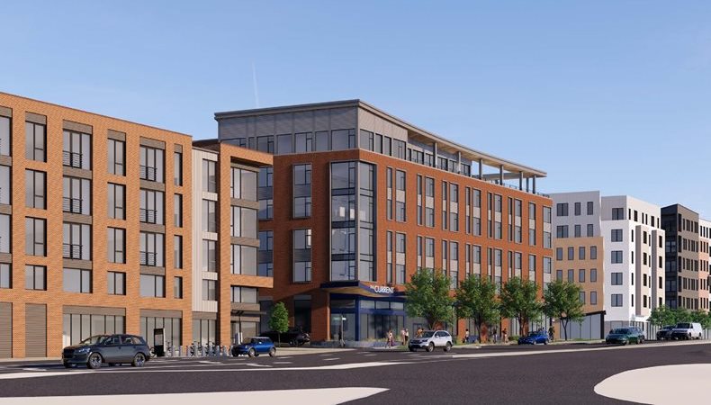
“The proposed project consists of a new six-story, pedestrian-oriented, mixed-use building with 117 rental apartment units, approximately 8,289 square feet of shared amenity space, and approximately 5,810 square feet of ground-floor retail, service, and accessory space. Amenities will include screened, covered ground-level parking for 54 vehicles tucked beneath the building.”
https://www.bostonplans.org/projects/development-projects/30-leo-m-birmingham-parkway
30 Leo M. Birmingham Parkway
“The proposed project consists of a new six-story, pedestrian-oriented, mixed-use building with 117 rental apartment units, approximately 8,289 square feet of shared amenity space, and approximately 5,810 square feet of ground-floor retail, service, and accessory space. Amenities will include screened, covered ground-level parking for 54 vehicles tucked beneath the building.”
https://www.bostonplans.org/projects/development-projects/30-leo-m-birmingham-parkway
stick n move
Superstar
- Joined
- Oct 14, 2009
- Messages
- 13,480
- Reaction score
- 24,526
Approved
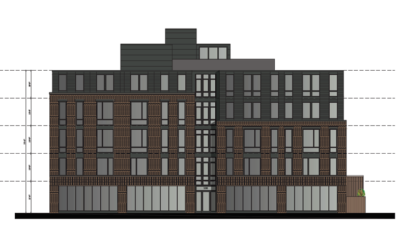
46 Leo Birmingham Parkway

“The proposed redevelopment of the Project Site calls for the construction of a six (6)-story, approximately 39,905 gross square foot, residential multi-family building (the “Proposed Project”). The Proposed Project is contemplated to include approximately thirty-eight (38) residential rental units, approximately 1,985 SF of lobby and amenity space including a sixth-floor outdoor patio for tenants, 13 accessory off-street parking spaces, and 60 bike storage spaces.”
https://www.bostonplans.org/projects/development-projects/46-leo-birmingham-parkway
46 Leo Birmingham Parkway
“The proposed redevelopment of the Project Site calls for the construction of a six (6)-story, approximately 39,905 gross square foot, residential multi-family building (the “Proposed Project”). The Proposed Project is contemplated to include approximately thirty-eight (38) residential rental units, approximately 1,985 SF of lobby and amenity space including a sixth-floor outdoor patio for tenants, 13 accessory off-street parking spaces, and 60 bike storage spaces.”
https://www.bostonplans.org/projects/development-projects/46-leo-birmingham-parkway
Equilibria
Senior Member
- Joined
- May 6, 2007
- Messages
- 7,229
- Reaction score
- 8,759
It's forgettable, but this is a very rapid change in the scale of that side of the street, and it's being accompanied by a similar lightspeed development on the other side.
Just gonna use this opportunity to refine my concept for redoing this whole area to include a Pike exit and Urban Rail station.

Just gonna use this opportunity to refine my concept for redoing this whole area to include a Pike exit and Urban Rail station.
Last edited:
RandomWalk
Senior Member
- Joined
- Feb 2, 2014
- Messages
- 3,793
- Reaction score
- 6,817
That part south of the Pike is a non-starter because of the large substation that was built recently on Electric Avenue.
Equilibria
Senior Member
- Joined
- May 6, 2007
- Messages
- 7,229
- Reaction score
- 8,759
That part south of the Pike is a non-starter because of the large substation that was built recently on Electric Avenue.
Probably, but this is a long-term thing. Once the substation is a couple of decades old, maybe it's replaceable.
Equilibria
Senior Member
- Joined
- May 6, 2007
- Messages
- 7,229
- Reaction score
- 8,759
DCR Final Master Plan for Herter Park and Soldiers Field Road:
I have to assume there's some sort of critical point being reached here, with both SFR and Western Avenue designated for major losses of capacity while the neighborhood between them dramatically densifies. The only transit improvements being put forward are a BRT-lite concept on Western, which is nice, but probably doesn't meet the capacity needed (particularly because bus services will still need to traverse the congested Western and River corridors in Cambridge to get to the Red Line).
SFR is an inefficient design and can certainly stand some rationalization, but this seems like a recipe for gridlock without significant transit improvements (a rail line).
Plen-T-Pak
Active Member
- Joined
- Jul 23, 2007
- Messages
- 253
- Reaction score
- 490
I think as long as they can manage adequate turn lanes then the lane reduction will work fine. But based on the limited details in the presentation, the intersection at Everett St and also near Eliot Bridge seem like they will be choke points. Getting rid of legacy highway designs and paved surface reduction is great but my main worry is public backlash due to too much pain inflicted for local drivers. I'm not sure the benefit of added park space in these locations will justify, in the public mind, the worsening of existing car traffic, similar to what happened near Forest Hills with the removal of the Casey Overpass.DCR Final Master Plan for Herter Park and Soldiers Field Road:
I have to assume there's some sort of critical point being reached here, with both SFR and Western Avenue designated for major losses of capacity while the neighborhood between them dramatically densifies. The only transit improvements being put forward are a BRT-lite concept on Western, which is nice, but probably doesn't meet the capacity needed (particularly because bus services will still need to traverse the congested Western and River corridors in Cambridge to get to the Red Line).
SFR is an inefficient design and can certainly stand some rationalization, but this seems like a recipe for gridlock without significant transit improvements (a rail line).
SFR is far too wide and rather dangerous because of the types of driving it encourages. Rarely actually sees too much volume.
Somewhat similarly, Western Ave just shouldn't be used for through traffic. It's not wide enough to handle it and the road diet there will make the type of travel there that shouldn't happen anyways impossible.
Somewhat similarly, Western Ave just shouldn't be used for through traffic. It's not wide enough to handle it and the road diet there will make the type of travel there that shouldn't happen anyways impossible.