Biking in Boston

A "bikes use ped signal" sign on the existing ped signal head would probably be enough for signalization, especially when paired with a reminder "left turn yield on green" sign for people turning from Third to Main. I rode through on the weekend and the ped signal was enough. I can't remember if there was a leading pedestrian interval, but that would be ideal to give cyclists heading straight a head start on people turning left.

The path itself is very wide and raised up off the main travel lane by several inches. The pinch point is still wide enough to ride through at a decent commuting speed, and hopefully whenever the tired plaza is renovated that giant block could be removed.

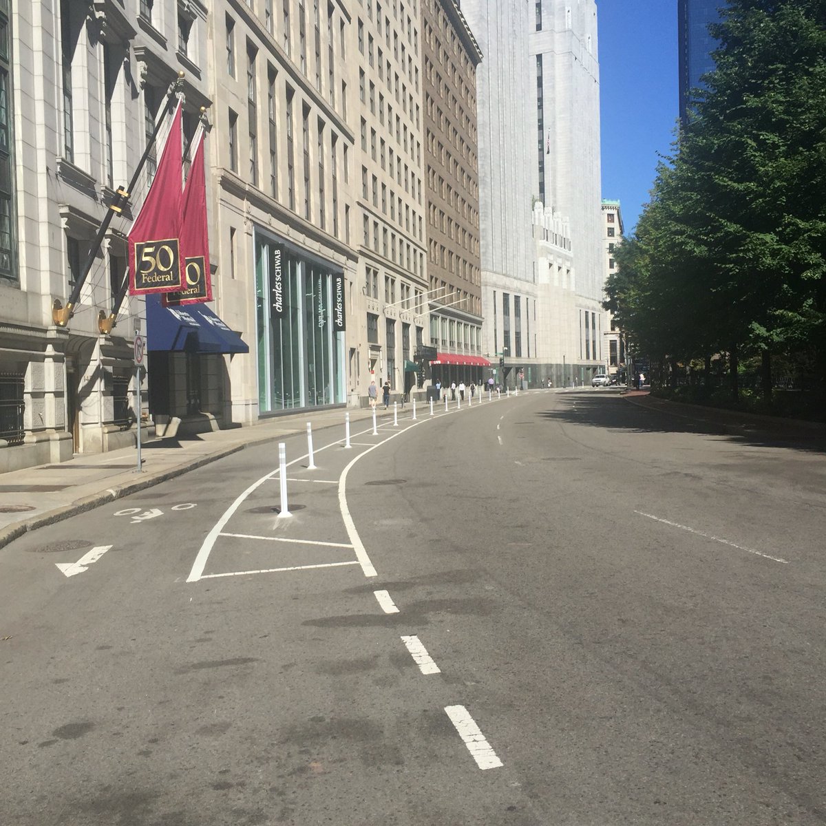
The transition from Main Street onto the contraflow lane isn't especially clear, it looks like you are supposed to use the raised crossing to merge onto the concrete triangle island and pick your way through pedestrian traffic before entering the lane.
QMXztXig.jpg
 
I do this too on that stretch, but occasionally I get into a rhythm with the bus where the bus passes me, then pulls over and stops in the bus lane, then while the bus is stopped I pass the bus, then bus passes me and pulls over at next stop and I have to pass it again... Etc... And I'm always very wary when passing stopped buses, gives me the jitters.

Ah, well the other place I often ride in traffic is Washington St. in Roslindale. Some days I'll pass 10 buses, so it doesn't phase me at all, though it's certainly not something I'd recommend for anybody who isn't pretty comfortable with high traffic conditions to begin with.
 
Is there a plan for some kind of special signal protection here?

The pinch point might not be that bad. Since this countra-flow is going the "wrong way" through a signal-controlled intersection, it might be a good idea to not have people on bikes coming at it "at speed"

Cambridge's response (which I saw on Twitter) was that the overall lane is 8ft wide and goes down to 4ft here, the minimum allowed.

So everything is fine and dandy...
 
They're going to need a "lane narrows" or "merge left" just as auto traffic would demand for a similar lane reduction.
 
Franklin Street in Allston is getting an upgrade to a Neighborway as part of the Public Space Invitational program:

Franklin Street (Allston) Neighborway
Location: Franklin Street, Allston
Proposed by: Mark Chase, Viola Augustin, Tom Bertulis

Using on-street murals, pavement markings and high-quality planters, the applicants intend for a community-led slow street intervention on Franklin St. in Allston to prioritize pedestrian and bicyclist safety.

The Franklin Street Neighborway is intended to serve the hundreds of residents in the Franklin Street neighborhood, and also bicyclists who are looking for a low-stress way to travel between existing bicycle facilities on Western Avenue in Allston and the Harvard Avenue/Packards Corner area.

There are a couple Neighborway streets in Somerville that only use paint for traffic calming: https://www.youtube.com/watch?v=U5SY6B2HFe4


Franklin Street today works very well as a quiet alternative to Harvard Street, but I've seen some surprisingly fast vehicle speeds. Maybe the paint the city is giving them will help, but I have more confidence in the planters.
 
Cambridge's response (which I saw on Twitter) was that the overall lane is 8ft wide and goes down to 4ft here, the minimum allowed.

So everything is fine and dandy...

In other words, we have very little respect for bikes as transportation and we found a loophole to do something unsafe. It's within the rules so it's not our fault if someone dies.
 
Went out for a ride before the festivities last weekend and took the opportunity to check in on a few ongoing projects.

Initial signs of change at the River Street deathtrap:

3TML0JW.jpg


Iyqh2XJ.jpg


Lots of construction around the Emerald Necklace/Route 9 crossing in Brookline Village:

Looking north toward Route 9 from the Leverett Pond area.
Mfar42V.jpg


Looking south toward Route 9 from River Rd.
D0qbggM.jpg


Looking north along River Rd.
I1WPxdp.jpg


Path construction behind Brookline Ice & Coal.
mtWkYva.jpg
 
It just not Cambridge, MA and England being utterly stupid laying out bike infra, Boston apparently has done it, too. From Bos311 this evening:
28hfx4n.jpg
at the corner of Green St and Washington St in JP.

And Boston did so well yesterday: a demonstration of the Mass Ave parking separated bike lane (on Beacon Street) and a cone separated bike lane at a construction site on Mass Ave just north of the bridge over Comm Ave.
 
Last edited:
Somerville screwed up with backwards sharrows this Spring, but I heard they fixed them quickly. They also sometimes to put them below the minimum distance from the curb when parked cars are present, basically guiding cyclists to ride in the door zone. Hopefully Boston gets this fixed ASAP.

Boston is going to make that demo parking protected bike lane permanent tonight: http://www.bostonglobe.com/metro/20...acon-street/g1IOEHFi9FWvsz2KyDLQrK/story.html

I didn't go to the demo on Tuesday but it looked a bit tight in photos. The state guidelines call for an 8 foot bike lane and 6 foot buffer which is impossible without removing lanes from Beacon Street, but hopefully they can at least exceed the minimum widths to allow passing and truly eliminate the possibility of dooring. This would also be a great chance to build in an accessible loading zone and a floating bus stop for the shuttles that stop on that block to show skeptics some of the finer details.
 
Cambridge installed sharrows on Cambridge street where Amanda Phillips was killed. Green bike lane striping through the intersection is coming next week.

The Boston Cyclists Union is studying parking in the area to build the case for creating protected bike lanes, which the city has endorsed in theory but hasn't made any movement on. And the city is studying whether to ban left turns off of Hampshire Street, which I think would be the best way to immediately create a sense of safety in the square.

The one time I rode to Cambridge without my camera rolling there was a woman laying on her horn at another driver who was patiently waiting for a gap in traffic to turn left from Hampshire SB to Cambridge EB. She ended up whipping out around him and into a crowd of cyclists while shouting "be more aggressive!" at the driver who actually had the decency to wait his turn.
 
The downtown Connect Historic Boston cycle track is delayed by a few months, and the rest of the project is pushed out to next year. Most of it will be finished in late autumn rather than late summer, and the final part by Christopher Columbus Park won't happen until next year.

The Charlestown cycle track was moved back from starting spring 2016 to starting in 2017, and the two shared streets projects will also not start until 2017.

See http://northendwaterfront.com/2016/08/cycle-track-north-end-set-paving-november-2016/ and https://www.boston.gov/transportation/connect-historic-boston
 
10 new Hubway stations have opened in Roxbury and Dorchester.

The article says that 10 stations will open in East Boston in the fall once they've finalized locations. I've never understood why Hubway tends to plan station expansions for the fall, just in time for the system to shut down for the winter.

Great that they're coming across the Harbor to Eastie. Just wish they'd put a few stations in Chelsea too then I could cut the 116/117 out of my commute entirely.
 
The Cambridge Redevelopment Authority selected Alta to do the streetscape redesign for Binney Street from Third to Main. Alta's proposal includes linking the existing Vassar Street and Binney Street separated bike lanes and adding a protected intersection at Broadway.
 
The Cambridge Redevelopment Authority selected Alta to do the streetscape redesign for Binney Street from Third to Main. Alta's proposal includes linking the existing Vassar Street and Binney Street separated bike lanes and adding a protected intersection at Broadway.

This is great news. Currently, that entire stretch highlighted in your googlemaps link is like some weird auto-centric parkway plunked on top of an urban area. It will be fantastic to convert that into a more walkable/bikeable stretch. Currently the MIT campus edge (e.g., vassar & main corner) feels cut off from that part of the kendall area
 
Flex Posts on Beacon!
f07xc3.jpg


Meanwhile DCR has been upgrading the bike and ped paths along Memorial Drive, too bad they couldn't figure out how to keep a pathway open during construction... they had sidewalk closed signs west of Mass Ave.
28lummw.jpg
 

Back
Top