Blue Line extension to Lynn

Honest question: would a tunnel be prohibitively expensive due to waterproofing requirements with the proximity to the marshes & the ocean?

"Prohibitively expensive" strikes me as a highly-relative concept in light of reasonable projections for what will be required to make the whole Eastern Seaboard's trackage "sea level rise-proof" over whatever duration of time we ought to be planning for.*

After all, we're talking about (presumably) dozens of miles of AMTRAK corridor from Downeastern's terminus in Brunswick, ME, all the way down to Miami, that are barely elevated above sea level, along with all regional coastal subway lines other than the Blue and Red Lines, and all regional commuter rail lines other than the Newburyport/Rockport and Greenbush lines.

Since about 1990, the best-fit line tracing the squiggles of all the tidal gauges NASA is tracking (check out the 2nd graph in particular) sure appears to be trending exponentially to me. It seems to me that AMTRAK and the slew of regional transit agencies--MBTA, MTA, PATH, and however many more there may be that share/operate on trackage that is 10 ft. or less above the mean high tide line--ought to be expending lots of time these days engaged in intense coordination and sharing of best practices/next-generation technologies and engineering/construction methods such that, whatever "sea level rise-proofing" is done on any one section of the Eastern Seaboard's trackage that is barely above the high tide line, it has been reviewed rigorously to confirm that the engineering/construction is the very best available at the time, for ALL transit agencies, be they federal, state, county level, whatevs.

*In the long run, since we are absolutely still on-target to achieve total glacial melting, thus leading to a 230-ft. inundation, any "sea level rise-proofing" for the Eastern Seaboard's trackage will be rendered pointless, given that, what, 95%-plus of the AMTRAK corridor and all of the paralleling/shared regional commuter/subway transit lines sit below that benchmark? That doesn't mean we still can't do a lot at intermediate levels of inundation, provided the political will and dedication of all stakeholder groups is adequate to the task, I figure.
 
Even though the #1 ROW is legally wide enough, I don’t think it reasonable to build literally a few feet from the apartments. The “not on my back porch” and “they promised it would only ever be a bike path” political case would be unusually legit, which is sad for Point of Pines because I agree it is a ideal node
 
Even though the #1 ROW is legally wide enough, I don’t think it reasonable to build literally a few feet from the apartments. The “not on my back porch” and “they promised it would only ever be a bike path” political case would be unusually legit, which is sad for Point of Pines because I agree it is a ideal node
Maybe this is a case where part of the cost is taking the apartments by eminent domain? The benefit for the rest of the neighborhood seems pretty high.
 
  • Like
Reactions: W-4
Even though the #1 ROW is legally wide enough, I don’t think it reasonable to build literally a few feet from the apartments. The “not on my back porch” and “they promised it would only ever be a bike path” political case would be unusually legit, which is sad for Point of Pines because I agree it is a ideal node

From looking at Google Maps there is some parking and a driveway to what I assume is a parking garage at One Carey in the ROW.

If you had to take all three, that would be a lot of people you would be displacing.
 
Even though the #1 ROW is legally wide enough, I don’t think it reasonable to build literally a few feet from the apartments. The “not on my back porch” and “they promised it would only ever be a bike path” political case would be unusually legit, which is sad for Point of Pines because I agree it is a ideal node
I disagree. ROW encroachment should never be rewarded. The builders knew what they were doing. Dont like the train outside your window? Sue the builder.
 
From looking at Google Maps there is some parking and a driveway to what I assume is a parking garage at One Carey in the ROW.

If you had to take all three, that would be a lot of people you would be displacing.
Short box tunnel (like Wellington on the Orange Line) with tunnel roof capping the cut and forming the replacement driveway to accommodate them without severing access. You're going to be ducking under North Shore Rd. for a little bit to get on-alignment for the bridge and create room in a cut to scoop out the PoP station, so it's the functional difference between ducking before One Carey or a little bit after. Waterproofing required, but it's a minimally shallow cut not 40 feet under-street like cut-and-cover.

It's snug, no doubt. This is high degree-of-difficulty. There needs to be a viable backup routing (like Option #2) if it doesn't fly through here. But there shouldn't need to be any residential eminent domaining to get it done. This is also a neighborhood dominated by a smattering of large-complex owners rather than too many individual homeowners, so the political stick is going to contour accordingly to that upper-crustier subset of landlords. It matters a lot whose property values are going to skyrocket by how much with the presence of rapid transit. The politics would be a different story if this were uniformly live-at-home small landowners with wholly traditional NIMBY triggers (which is why I'm sort of down on the Revere St. ROW widening for #4). Mixed bag. They at least need to test the limits by thoroughly studying it.
Where would the station for PofP be located?
 
I'm sure this has been well hashed before, but would there be any appetite for further extensions beyond Lynn? Or would be future Regional Rail frequencies be more than enough? / Is there any way to get some form of service to Peabody?
 
I'm sure this has been well hashed before, but would there be any appetite for further extensions beyond Lynn? Or would be future Regional Rail frequencies be more than enough? / Is there any way to get some form of service to Peabody?
Lynn-Salem was officially proposed by the state in the 2004 Program for Mass Transportation. +15,500 daily increase in ridership on Blue, +8900 all-new transit riders. $363M (2004 $) capital cost, with a super-low cost-per-rider rating (helps that the ROW is pre-graded for quad-track through Swampscott Station with an over-provisioned swamp causeway to cut down on the EIS'ing). Despite the fact that Wonderland-Lynn hadn't yet been built, the top and bottom lines were good enough to net it a Medium project rating as a standalone. No Peabody because it's infeasible to widen the Salem tunnel to 3-4 tracks, so it would have to stub out Downtown south-of-portal. Presumably then you could designate Salem as its own breakaway bus terminal for dense last-mile frequencies throughout Peabody/Danvers/Beverly.

So, yes...the corridor is absolutely dense enough for it. Proportionately speaking the net increase in riders from doing true-Blue to Salem absolutely dwarfs the best-case net increase in riders from doing Regional Rail frequencies on the Eastern. Probably 2-3x as high. It's a very worthy project, in similar heft to how the Braintree Branch of Red was a worthy project that couldn't ever have been approximated in the real world by bestest-possible Purple Line builds. We just don't get to talk about how good it empirically is because Wonderland-Lynn is of course still unbuilt after 75 years of talking.

The PMT didn't speculate on intermediate stations, but the likeliest are:
  • East Lynn: Chatham St. at the old B&M stop. 456 bus, ~4 blocks of the 441, 442, 455.
  • Swampscott: outright eats the CR station. 455 bus, ~3 blocks of the 441.
  • Essex/"Hawthorne's Crossing": spacer before the swamp. Not too immediately dense, but walking distance to Swampscott Mall and some big Mall-adjacent apartment towers, and diverging point for the 455 bus. Probably rates worthy if the Mall area gets some TOD redev elbow grease in-tandem.
  • Salem State University: Jefferson Ave. at one of the officially-proposed Options for "South Salem" Commuter Rail. Would outright eat any pre-existing CR stop.
  • Downtown Salem: Surface-level to Mill St. behind the police station, probably displacing the plumbing supply store in the process. Presumes that the disused south-of-portal CR station in the pit would get refurbbed/reactivated so it's a a proper superstation transfer.
 
Last edited:
Looking at Google Earth, south of Revere Street gets too tight. The residential yards are close to the 2-track ROW on the east side, and then there is a public park on the west side, Several back yards could be shaved back but politically that would be DOA. Here's the view of this on Google Earth: https://earth.google.com/web/@42.41725847,-70.99469108,3.39596473a,203.62230272d,35y,0h,0t,0r
In a crazy transit pitch scenario, I would elevate the BL over the Eastern Branch RR through this tight stretch, but I'm sure the residences along there would not want that, especially as it would require a BL flyover above the Revere St crossing..​
I checked the Dunn Road houses on http://gis.revere.org/?extent=241271,907405,241845,907690. The ROW proper is 80ft wide, and the yards encroach on the ROW. Yes they'd lose half their backyards, but it's not really 'theirs' to begin with, so it shoiuld be doable politically.

Sidebar: I'm amused at the ghost roads between Dunn and Wonderland.
 
Downtown Salem: Surface-level to Mill St. behind the police station, probably displacing the plumbing supply store in the process. Presumes that the disused south-of-portal CR station in the pit would get refurbbed/reactivated so it's a a proper superstation transfer.
A couple of questions, if you don't mind? What happens to the National Grid substation and the Police station itself? Aren't they blockers, or can the MBTA work out a land swap with that adjecent huge parcel of theirs?

Speaking of said huge parcels. Was there a historical RoW here to Peabody? It lines up pretty nearly with that branch. (I assume no chance of a tunnel?)
 
Maybe this is a case where part of the cost is taking the apartments by eminent domain? The benefit for the rest of the neighborhood seems pretty high.

Note, technically One Carey Circle is a condo complex--many dozens of units if you consult the Revere assessor's database. Many many years ago, when my cousin lived there, I snapped a photo of the garage's attached surface lot, and posted it on this thread (I think--or a related thread), to show how the old Boston Revere Beach & Lynn RR's ROW emerged from out of the marshlands and petered-out right at the One Carey Circle parking lot. I appended the images to post #216 upthread, in May 2016--but they've since disappeared into the maw of the Interwebs.

Anyway, the EGE gives a good explanation upthread, in post #217, explaining how a National Grid subsidiary ended-up acquiring the ROW. And F-Line then gives a typically comprehensive overview in post #227 upthread, re: ROWs, takings, etc., that is worth a revisiting.

The sun will rise, the sun will set; the piping plovers will come-and-go at Point of Pines; aging Boomers will post/share on social media nostalgic photos of Revere Beach and its amusement-park complex from the golden age of the 1950s; beach patrons will go through all the familiar rituals (Kelly's Roast Beef, sandcastle-building competitions, etc.) each summer; the Atlantic will erode/inundate the shoreline a little further each year... and the Blue Line Extension to Lynn will remain unbuilt.
 
A couple of questions, if you don't mind? What happens to the National Grid substation and the Police station itself? Aren't they blockers, or can the MBTA work out a land swap with that adjecent huge parcel of theirs?

Speaking of said huge parcels. Was there a historical RoW here to Peabody? It lines up pretty nearly with that branch. (I assume no chance of a tunnel?)
Substation's got expansion room on it so you just jack up the equipment closest to the wall and move it at most 20 feet. The PD building would lose the whole of its rear-access driveway, but the nice-looking (if utilitarian) modern brick building itself wouldn't need to go in order to have tracks riding up along the wall. Whether it continues to host Police HQ or goes over to some other civic use is for the fine-print to square. Downtown's going to get a huge reinvestment wadded up in the transit build, so if the Police are in a mood to demand a new full-service HQ in the deal there'll be ripe opportunities to accommodate that. I'm assuming that the only business displacements would be the plumbing store on Margin St. (probably site of the station busway) and the insurance broker sitting in the ex- bank branch facing Mill (site of the new combo Blue/Purple headhouse).

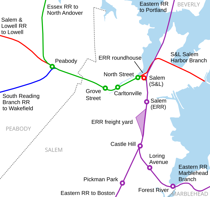
No...there was never alternate ROW to Peabody. Salem Station was built at-grade as the original 1830's terminus of the Eastern RR, then there was a 500-foot tunnel built under Washington in the 1840's for the Eastern's Salem-Ipswich extension. The Salem & Lowell (Peabody Branch) met it at the current junction in 1850 outside the tunnel portal, and travel to Peabody has always used that junction. The tunnel was widened and lengthened in the end-1800's, and then lengthened again in 1957-58 to zap the south-end grade crossings @ Mill and Norman St.'s. The Mill-Norman block has that particular urban renewal-y vibe with its open-air parking lots because of what buildings got nuked for that 50's grade separation.

Although not directly related to BLX itself, does the Salem tunnel have the space to accommodate a second track? Or would it be feasible to widen the tunnel to fit a second track?
 
Although not directly related to BLX itself, does the Salem tunnel have the space to accommodate a second track? Or would it be feasible to widen the tunnel to fit a second track?
The 1950's southern extension is single-track only (double-to-single switch was a hair inside the portal until the Mill St. station was abandoned in 1987). The circa-1890's renovated northern segment was double-track, and the Peabody Branch turnout last used the second-track berth. Part of the attractiveness of reanimating the Peabody Branch is that it would re-tap the extra track and pose virtually no constraints to existing tunnel capacity. CR capacity is fine if they follow the contours (namely: using the Peabody turnout as a mainline service increaser, doubling-up the platforms outside the north portal at the current station, and building the South Salem infill station so tunnel slots can be more precision-timed between the stops).

Of course, with BLX you're fishing for 3, if not 4, tracks to run both modes here. And there definitely is not enough room under built-up Washington for that widening without it turning into a billion-dollar project.

EDIT: Here's a Wikipedia schematic of the Salem Tunnel. And a Wikipedia schematic of Salem RR stations through the years. I assume these are EGE's handiwork. . .
512px-Salem_downtown_stations_map.svg.png


819px-Salem_stations_and_lines_map.svg.png
 
Last edited:
I checked the Dunn Road houses on http://gis.revere.org/?extent=241271,907405,241845,907690. The ROW proper is 80ft wide, and the yards encroach on the ROW. Yes they'd lose half their backyards, but it's not really 'theirs' to begin with, so it should be doable politically.
Thank you for the info. The ROW all of a sudden expands to 4-tracks wide a couple of hundred feet south of Revere St., so the two track ROW south of that point is clearly due to encroachment of backyards. In this age of hyper-NIMBYism, I have my doubts it could be recovered. Even on the strictly legal front I would expect lawsuits. I looked at historical aerials and the encroachments go back many decades, so they would possibly use that reason to fight any taking of property. Of course there is always eminent domain, but that throws it all into the political realm.
 
Thank you for the info. The ROW all of a sudden expands to 4-tracks wide a couple of hundred feet south of Revere St., so the two track ROW south of that point is clearly due to encroachment of backyards. In this age of hyper-NIMBYism, I have my doubts it could be recovered. Even on the strictly legal front I would expect lawsuits. I looked at historical aerials and the encroachments go back many decades, so they would possibly use that reason to fight any taking of property. Of course there is always eminent domain, but that throws it all into the political realm.
Adverse possession(squatter's rights) does not apply to railroad ROWs, I believe.
 
I don’t think it’s subject to rights from adverse possession. Instead, the T should be able to clear anything sitting on their property.
 

Back
Top