You are using an out of date browser. It may not display this or other websites correctly.
You should upgrade or use an alternative browser.
You should upgrade or use an alternative browser.
Boston Harbor Flood Protection Projects
- Thread starter czsz
- Start date
stick n move
Superstar
- Joined
- Oct 14, 2009
- Messages
- 13,480
- Reaction score
- 24,526
Morrissey revamp presents ‘tremendous’ opportunity, DCR chief says in site visit
“I know that there’s a tremendous amount of opportunity around thinking of Morrissey through a climate lens, and thinking about how we create a habitat that helps the landscape, and the design of it is a model for green infrastructure, and then also we’re hitting those other markers that we want to hit,” he told the Reporter in a newsroom interview.
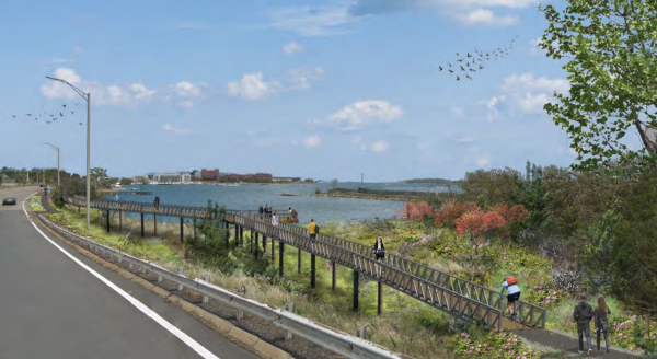
Arrigo joined Reporter editors for a walk through the construction area that is just by the I-93 off-ramp, where workers in hard hats drove pilings into the ground as part of a project to build a 3,620-foot long pathway, elevated above the salt marsh and tidal flats that make up the cove. Once complete, the pathway will connect Tenean Beach to Morrissey, and the Neponset River Greenway Trail to the Harborwalk by UMass Boston and all the way downtown.
There have been improvements to Morrissey, such as intersection upgrades. “But there’s a much bigger, grander thought to Morrissey,” Arrigo said, and DCR officials have been in touch with Quentin Palfrey, Healey’s director of federal funds and infrastructure, to ensure the agency is “in line to get every federal dollar that we can.”
https://www.dotnews.com/2023/morrissey-revamp-presents-tremendous-opportunity-dcr-chief-says-site
“I know that there’s a tremendous amount of opportunity around thinking of Morrissey through a climate lens, and thinking about how we create a habitat that helps the landscape, and the design of it is a model for green infrastructure, and then also we’re hitting those other markers that we want to hit,” he told the Reporter in a newsroom interview.
Arrigo joined Reporter editors for a walk through the construction area that is just by the I-93 off-ramp, where workers in hard hats drove pilings into the ground as part of a project to build a 3,620-foot long pathway, elevated above the salt marsh and tidal flats that make up the cove. Once complete, the pathway will connect Tenean Beach to Morrissey, and the Neponset River Greenway Trail to the Harborwalk by UMass Boston and all the way downtown.
There have been improvements to Morrissey, such as intersection upgrades. “But there’s a much bigger, grander thought to Morrissey,” Arrigo said, and DCR officials have been in touch with Quentin Palfrey, Healey’s director of federal funds and infrastructure, to ensure the agency is “in line to get every federal dollar that we can.”
https://www.dotnews.com/2023/morrissey-revamp-presents-tremendous-opportunity-dcr-chief-says-site
Justbuildit
Senior Member
- Joined
- Nov 27, 2022
- Messages
- 1,088
- Reaction score
- 3,803
Not sure if this is flood mitigation per se, but anyone have info on what looks like a rebuild of the harbor walk on the Fort Point side of the channel between Congress and Summer? There’s a floating rig that has driven piles and is putting up some large beams parallel to the current walkway

Aprehensive_Words
Active Member
- Joined
- Oct 18, 2022
- Messages
- 278
- Reaction score
- 543
Flood mitigation would make sense. That stretch is perennially swamped at high tide during storms.
bigeman312
Senior Member
- Joined
- Jul 19, 2012
- Messages
- 2,408
- Reaction score
- 2,511
Crossposting here:
Boston Harbor was in minor flood stage (12.5-14 ft tidal height) for two hours this morning, from about 7:00 to 9:00, peaking at 13.33 ft.
For perspective, this was the 29th highest crest recorded in Boston Harbor history.
While not unprecedented, this level of flooding is notable and not something that happens every month. The last tide this high was on January 13 when a storm brought a crest of 14.41 ft.
Today marks the third time Boston Harbor has reached flood stage this year after reaching that level four times last year and six times in 2022.
Looking at the bigger picture, Boston Harbor reaches flood stage much more often than in decades past. To demonstrate this fact, here are the number of times Boston Harbor has reached flood stage per decade, on record:
What was a once-a-year flood in the 1980-2009 period has become a six-times-a-year flood now.
Boston Harbor was in minor flood stage (12.5-14 ft tidal height) for two hours this morning, from about 7:00 to 9:00, peaking at 13.33 ft.
For perspective, this was the 29th highest crest recorded in Boston Harbor history.
While not unprecedented, this level of flooding is notable and not something that happens every month. The last tide this high was on January 13 when a storm brought a crest of 14.41 ft.
Today marks the third time Boston Harbor has reached flood stage this year after reaching that level four times last year and six times in 2022.
Looking at the bigger picture, Boston Harbor reaches flood stage much more often than in decades past. To demonstrate this fact, here are the number of times Boston Harbor has reached flood stage per decade, on record:
- 2020s: 25*
- 2010s: 21
- 2000s: 11
- 1990s: 10
- 1980s: 7
What was a once-a-year flood in the 1980-2009 period has become a six-times-a-year flood now.
BosMaineiac
Active Member
- Joined
- Nov 25, 2020
- Messages
- 245
- Reaction score
- 447
I think it’s time top officials at least start floating the idea of a full harbor barrier
bigeman312
Senior Member
- Joined
- Jul 19, 2012
- Messages
- 2,408
- Reaction score
- 2,511
Crossposting here:
Boston Harbor was in minor flood stage (12.5-14 ft tidal height) for two hours this morning, from about 7:00 to 9:00, peaking at 13.33 ft.
For perspective, this was the 29th highest crest recorded in Boston Harbor history.
While not unprecedented, this level of flooding is notable and not something that happens every month. The last tide this high was on January 13 when a storm brought a crest of 14.41 ft.
Today marks the third time Boston Harbor has reached flood stage this year after reaching that level four times last year and six times in 2022.
Looking at the bigger picture, Boston Harbor reaches flood stage much more often than in decades past. To demonstrate this fact, here are the number of times Boston Harbor has reached flood stage per decade, on record:
* through less than 4.5 years!
- 2020s: 25*
- 2010s: 21
- 2000s: 11
- 1990s: 10
- 1980s: 7
What was a once-a-year flood in the 1980-2009 period has become a six-times-a-year flood now.
Boston Harbor entered minor flood stage for an hour last night, so you can add that on to the total.
Suffolk 83
Senior Member
- Joined
- Nov 14, 2007
- Messages
- 3,024
- Reaction score
- 2,512
Id like to reference these numbers.... source?Crossposting here:
Boston Harbor was in minor flood stage (12.5-14 ft tidal height) for two hours this morning, from about 7:00 to 9:00, peaking at 13.33 ft.
For perspective, this was the 29th highest crest recorded in Boston Harbor history.
While not unprecedented, this level of flooding is notable and not something that happens every month. The last tide this high was on January 13 when a storm brought a crest of 14.41 ft.
Today marks the third time Boston Harbor has reached flood stage this year after reaching that level four times last year and six times in 2022.
Looking at the bigger picture, Boston Harbor reaches flood stage much more often than in decades past. To demonstrate this fact, here are the number of times Boston Harbor has reached flood stage per decade, on record:
* through less than 4.5 years!
- 2020s: 25*
- 2010s: 21
- 2000s: 11
- 1990s: 10
- 1980s: 7
What was a once-a-year flood in the 1980-2009 period has become a six-times-a-year flood now.
I haven’t counted but I’d think this is where these numbers come from:Id like to reference these numbers.... source?
NWS Water weather page for Boston harbor tide measurements
With this raw data of recent crests being the one that is being referenced.
bigeman312
Senior Member
- Joined
- Jul 19, 2012
- Messages
- 2,408
- Reaction score
- 2,511
Id like to reference these numbers.... source?
@eber nailed it. NWS data.
Worth noting that the recent crests don’t have (at least) the three most recent instances of flood stage. Also worth noting that Boston Harbor briefly entered flood stage last night (for about a half hour and only by a few inches).
For more recent data, it is visible through the tabular data link.
Delvin4519
Active Member
- Joined
- Oct 8, 2022
- Messages
- 937
- Reaction score
- 1,612
I can't see this happening without Boston first experiencing some catastrophic, costly, flooding event that displaces some residents in affordable housing, floods a section of the Red Orange, and Green Lines, and shuts down Logan Airport (briefly). Only after such disaster would there be the will to actually get the massive harbor barrier project done.I think it’s time top officials at least start floating the idea of a full harbor barrier
I would wish Boston could just have a barrier before it happens, but realistically, it's going to be the other way around. The flood disaster will happen before a barrier is even committed to (let alone done to completion and operational).
bigeman312
Senior Member
- Joined
- Jul 19, 2012
- Messages
- 2,408
- Reaction score
- 2,511
I can't see this happening without Boston first experiencing some catastrophic, costly, flooding event that displaces some residents in affordable housing, floods a section of the Red Orange, and Green Lines, and shuts down Logan Airport (briefly). Only after such disaster would there be the will to actually get the massive harbor barrier project done.
I would wish Boston could just have a barrier before it happens, but realistically, it's going to be the other way around. The flood disaster will happen before a barrier is even committed to (let alone done to completion and operational).
I 100% agree with this, unfortunately.
CSU Tropical Weather and Climate Research is the leading body for predicting and measuring Atlantic Hurricane Seasons. Their predictions are well-respected and followed closely. They recently released their 2024 forecast and it is their highest prediction of all-time:
- 23 named storms
- 11 hurricanes
- 5 major hurricanes
- 210 Accumulated Cyclone Energy (ACE)
- 62% probability of a major hurricane making landfall on the US coastline
- 34% probability for the US East Coast, including the Florida peninsula
- 49% probability of a named storm impacting Massachusetts
- 23% for Suffolk County specifically
- 23% probability of a hurricane impacting Massachusetts
- 8% for Suffolk County specifically
- 5% probability of a major hurricane impacting Massachusetts
- 1% for Suffolk County specifically
It's been four years since a tropical cyclone brought tropical storm conditions to Boston (Isaias in 2020). It's probable that Boston will have another within the next three years, and highly probable by the end of the decade. With higher water levels than ever before, the question is whether the storm's timing and track will bring an event similar to what @Delvin4519 describes.
Boston hasn't experienced hurricane conditions in the 21st century, but such an event is certainly not unprecedented. Bob, Gloria, Donna, Edna, and Carol all brought hurricane conditions to Boston or near Boston in the second half of the 20th century. Boston is on a bit of borrowed time and that has led to a false sense of security. It's probable that Boston experiences hurricane conditions within the next nine years and highly probable within the next 20. With water levels much higher than the last hurricane hit, that will truly be a wake-up call.
Delvin4519
Active Member
- Joined
- Oct 8, 2022
- Messages
- 937
- Reaction score
- 1,612
New York City was slammed by Hurricane Irene with a almost-direct hit in 2011 (near-hurrcane force at landfall), and followed by Sandy again in 2012 only a year later (the latter of which was a large-sized storm). NYC would later go on to be hit with flooding from Hurricane Ida in 2021 (the remnants of which tracked overland), and more tropical rainfall again 2 years later.


It's crazy to me how Boston has been dodging bullets since 1991. Boston's top 10 record high water levels prior to the 2018 nor-easters all came from winter storms or nor-easters, none from any hurricane.
The 1938, and 1954 hurricanes all tracked too far to the west (1954 had 2 canes but the latter struck too far east). The one in 1991 was only a cat 2 and not a cat 3 like in 1938 or 1954. Boston has been on borrowed time for far too long.
stellarfun
Senior Member
- Joined
- Dec 28, 2006
- Messages
- 5,726
- Reaction score
- 1,586
Globe article from April 5, on Boston's reliance on private developers to fund projects that provide resilience against near-term sea level rise.

 www.bostonglobe.com
Boston’s defenses against rising seas lean on private development. What happens when the money dries up? - The Boston Globe
Several flood-protection projects like sea walls, berms, and elevated land are tangled up in large developments that now face slowdowns.
www.bostonglobe.com
...At the 15-acre power plant site, developers Hilco Redevelopment Partners and Redgate said they will build a $12 million, 659-foot-long sea wall. At the former Bayside Expo Center near the University of Massachusetts Boston, developer Accordia Partners plans a 2.7-acre waterfront park at its Dorchester Bay City project. That park, along with an estimated $18.5 million in resiliency improvements nearby and elevating the site itself, will protect both the project’s 36 acres and parts of South Boston and Dorchester behind it.
And in Charlestown, developer Flatley Co. plans to invest $50 million in a roughly half-mile-long barrier along the Mystic River near Sullivan Square — a wall that city development officials say will protect not just Flatley’s 1.8-million-square-foot project but also more than “200 acres of Charlestown, plus hundreds of acres of Somerville and Cambridge.”
JeffDowntown
Senior Member
- Joined
- May 28, 2007
- Messages
- 5,048
- Reaction score
- 4,225
And particularly problematic as development stalls for this cycle, leaving huge holes in the planned protection network.Globe article from April 5, on Boston's reliance on private developers to fund projects that provide resilience against near-term sea level rise.
Boston’s defenses against rising seas lean on private development. What happens when the money dries up? - The Boston Globe
Several flood-protection projects like sea walls, berms, and elevated land are tangled up in large developments that now face slowdowns.
Delvin4519
Active Member
- Joined
- Oct 8, 2022
- Messages
- 937
- Reaction score
- 1,612
With Hurricane Milton and Helene having wrecked havoc in the US South, I decided to compare the urban areas map tool with the flood maps. I kinda wish there was an easier way to compare both maps, but it seems like the amount of urban land in Boston that is low lying is extremely high, so a hurricane probably is able to to wipe most of Boston off the map. Perhaps at least half of Boston's residents will lose their homes completely when the next big cane comes?
The only densly populated areas that are on meaningfully high ground are: a strip of Somerville, a segment of Everett, some of Brighton and Brookline, most of Mattapan and Hyde Park, West Roxbury, Rozzie, Watertown, some of JP, a portion of Arlington, and a small strip of Southie.
Of those with transit access, only Brookline, JP, and Somerville have access to both rapid transit, and are on high enough ground to avoid losing their housing stock to hurricanes and/or flooding.
The storm surge in Hurricane Milton was up to 15 feet of surge. 15 feet of storm surge, is well, quite a lot.
JeffDowntown
Senior Member
- Joined
- May 28, 2007
- Messages
- 5,048
- Reaction score
- 4,225
Boston Globe article today on just this point.With Hurricane Milton and Helene having wrecked havoc in the US South, I decided to compare the urban areas map tool with the flood maps. I kinda wish there was an easier way to compare both maps, but it seems like the amount of urban land in Boston that is low lying is extremely high, so a hurricane probably is able to to wipe most of Boston off the map. Perhaps at least half of Boston's residents will lose their homes completely when the next big cane comes?
The only densly populated areas that are on meaningfully high ground are: a strip of Somerville, a segment of Everett, some of Brighton and Brookline, most of Mattapan and Hyde Park, West Roxbury, Rozzie, Watertown, some of JP, a portion of Arlington, and a small strip of Southie.
Of those with transit access, only Brookline, JP, and Somerville have access to both rapid transit, and are on high enough ground to avoid losing their housing stock to hurricanes and/or flooding.
The storm surge in Hurricane Milton was up to 15 feet of surge. 15 feet of storm surge, is well, quite a lot.
View attachment 56773

Could a big hurricane whack New England? ‘More of a question of when than if.’ - The Boston Globe
As the Southeastern United States recovers from a pair of massive storms, how is climate change loading the dice for a hurricane to hit New England?
www.bostonglobe.com
Delvin4519
Active Member
- Joined
- Oct 8, 2022
- Messages
- 937
- Reaction score
- 1,612
Boston Globe article today on just this point.
Could a big hurricane whack New England? ‘More of a question of when than if.’ - The Boston Globe
As the Southeastern United States recovers from a pair of massive storms, how is climate change loading the dice for a hurricane to hit New England?
Thank goodness the Globe has stepped in just in time to report on this issue.
A city like Toronto, Chicago, or Edmonton; can devote a lot of time, attention, and funding into transit expansive to drive down emissions. Toronto, Chicago, and Edmonton can spend as much $ on transit expansion as they want without worrying about needing a giant flood barrier to protect themselves, since they are far inland.
Meanwhile Boston not only has to play several decades of catch-up in transit expansion, but also spend billions of a massive flood barrier. If Boston receives only a fraction of the funding, they could spend it on transit expansion, but that's just going to be flooded by the next summer the next hurricane strikes, if Boston opts to use funding to build the food barrier, now there will be no more transit expansion and we're not doing anything to drive down emissions, because the building the flood barrier eats all of that funding.
While it's true no one is talking about abandoning Logan Airport, that we need to protect all of this infrastructure, it's all vision talk and not actually in the budget. Where's Boston going to get funding for both a massive transit expansion and this big giant flood barrier? Unlike Toronto, Chicago, or Edmonton; Boston has got to somehow find funding for both transit expansion and the flood barrier.
stellarfun
Senior Member
- Joined
- Dec 28, 2006
- Messages
- 5,726
- Reaction score
- 1,586
When measuring storm surge in a hurricane in the Northern hemisphere, the highest surge values are on the right-side quadrants of a hurricane .that is traveling poleward. The highest storm surges produced by the Great Hurricane of 1938 are shown in the images below.
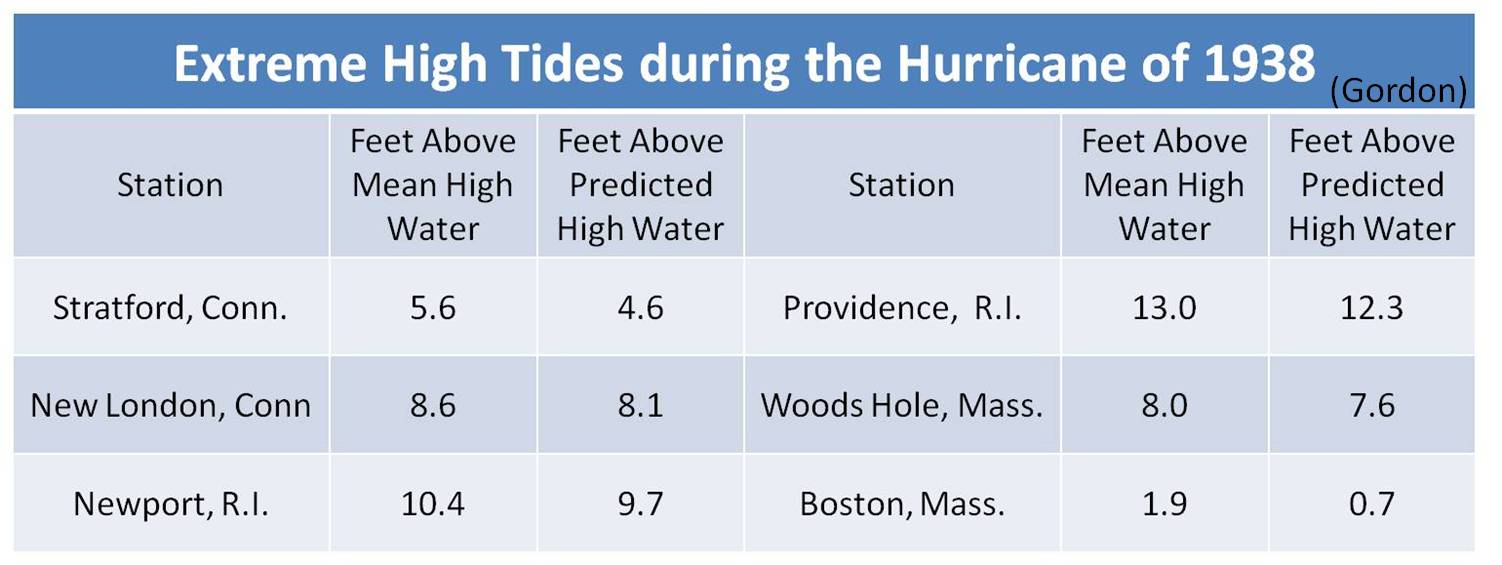
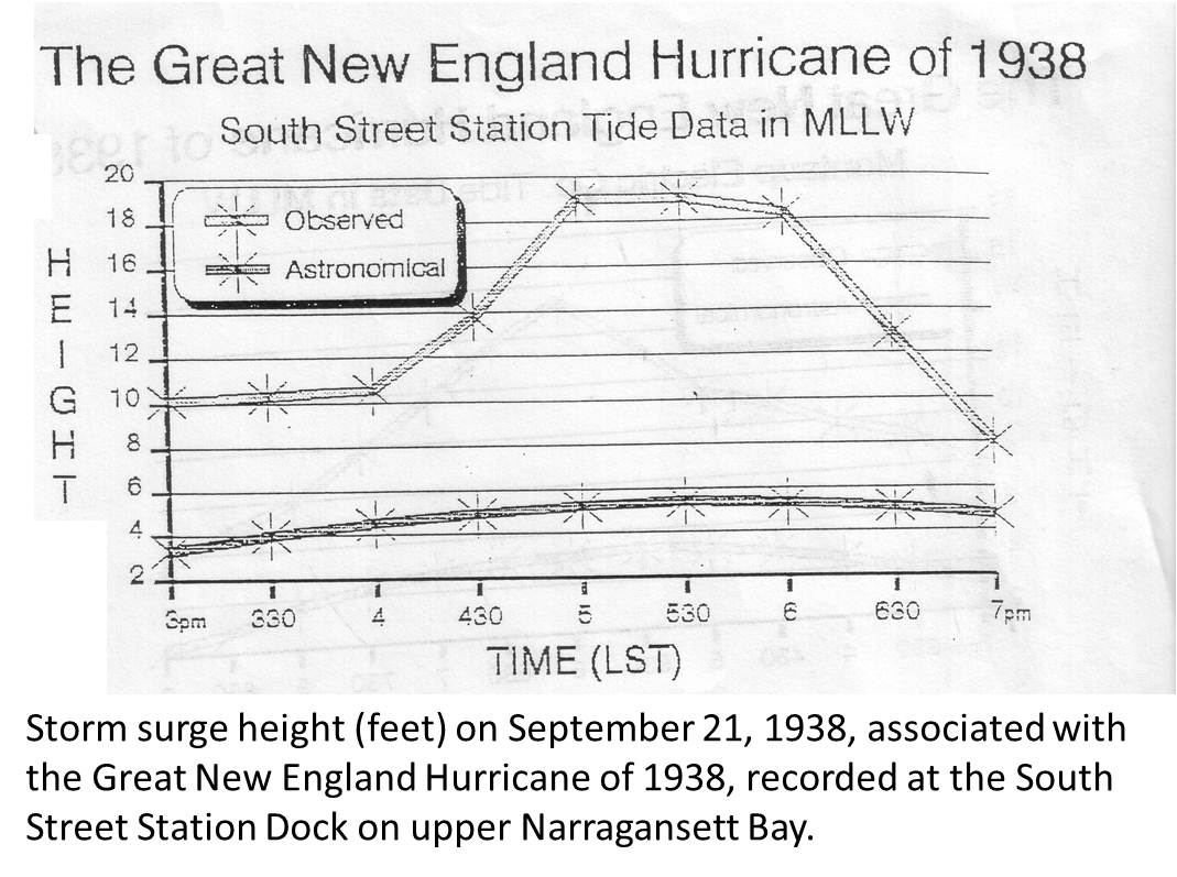
The referenced South Street Station dock is at 360 Eddy St. in Providence. What happened in Providence in 1938 is similar, from a phenomenon standpoint, to what happened t in Tampa Bay during Helene. There was no surge in Tampa Bay during Milton.
One would be hard-pressed to develop a scenario where a hurricane would generate a storm surge of 15 feet in Boston Harbor, or on any community facing Massachusetts Bay. Also a hurricane is not a Nor'easter, Sandy's storm surge along the east-facing shoreline of Massachusetts Bay was 2.5-4.5 feet. On the south coast of Massachusetts, Sandy's surge was 4-6 feet. While Sandy and historic nor'easters generated waves of 25 feet in Massachusetts Bay, Boston Harbor is not Scituate
Bet you what we’ll get is this: neither.Thank goodness the Globe has stepped in just in time to report on this issue.
A city like Toronto, Chicago, or Edmonton; can devote a lot of time, attention, and funding into transit expansive to drive down emissions. Toronto, Chicago, and Edmonton can spend as much $ on transit expansion as they want without worrying about needing a giant flood barrier to protect themselves, since they are far inland.
Meanwhile Boston not only has to play several decades of catch-up in transit expansion, but also spend billions of a massive flood barrier. If Boston receives only a fraction of the funding, they could spend it on transit expansion, but that's just going to be flooded by the next summer the next hurricane strikes, if Boston opts to use funding to build the food barrier, now there will be no more transit expansion and we're not doing anything to drive down emissions, because the building the flood barrier eats all of that funding.
While it's true no one is talking about abandoning Logan Airport, that we need to protect all of this infrastructure, it's all vision talk and not actually in the budget. Where's Boston going to get funding for both a massive transit expansion and this big giant flood barrier? Unlike Toronto, Chicago, or Edmonton; Boston has got to somehow find funding for both transit expansion and the flood barrier.