Commonwealth Avenue Improvement Project

Comm Ave already has 10' lanes.

The liability issue is bunk. If that were true, then we would sue engineers for building high speed roadways in our cities that directly result in people getting killed.

I'll be less charitable than Shepard. We know very well about the traffic engineering religion around here. You're not going to dazzle us by citing AASHTO or ITE. That's why I have no compunction about challenging you on this. We know that there is no scientific basis for many of the so-called axioms of the traffic engineering field. In fact, there's quite a bit of evidence marshaled against your regulations, evidence that Jeff Speck presented, but you seem to have ignored in your zeal to make a point.

That's why people like me are challenging traffic engineers. You create these rules and regulations that you claim make things safer, but are unsafe in fact. Motorists get to go fast, pedestrians and bicyclists pay the price in blood. Enough's enough.

Wow.

Why don't you just take up your anti-car beef with the direct descendants of Gottlieb Daimler?

Seriously. We have standards to which we are held in designing. Someone had to come up with them originally and they evolved over the years. 20 years ago no one gave a damn about bicycle accommodation around here. Now we have the complete streets program. I myself have worked on two separate projects in municipalities north of Boston where we've reconstructed over three miles substandard roadways to accommodate both an 11' wide vehicle travel lane along with a 5' bicycle lane on both sides of the road along with a 5' sidewalk in a primarily suburban setting. These projects have required a boatload of engineering to design retaining walls, utility relocation/replacement and easement acquisition, all while coordinating with hundreds of abutters to maintain access to their properties and keeping them involved in the design process.

We have to design with pedestrians and bicycles in mind nowadays. It's a non-starter otherwise. Change doesn't happen overnight, but it's moving faster than it ever has before. And while the dynamic hasn't inverted to the point you seeming hope it does where peds and bikes are the primary design concern, it sure as hell doesn't leave them hanging in the lurch like it used to.

So yeah, I get offended when you give your passion play for the blood of the fallen pedestrians (because no one dies in car accidents either) and turn up your nose at the idea of actually having tried and true tested guideline for which I am required to adhere to.

Oh, and the area by BU on Comm Ave. has 11' lanes. Just double checked.
 
NorthShore said:
Why don't you just take up your anti-car beef with the direct descendants of Gottlieb Daimler?
You are being extremist here. It is not "anti-car" to suggest that speeding vehicle are bad for the rest of us. This has been a longstanding problem. Any time anyone makes a suggestion that perhaps drivers should slow down, they get instantly attacked as "anti-car." That's how overly sensitive drivers are. It's a ridiculous attitude, and enough's enough. You can have your car, but you do not have to go that fast on the streets in my neighborhood.


turn up your nose at the idea of actually having tried and true tested guideline for which I am required to adhere to.
11' and 12' lanes are not a "tried and true tested" guideline. That is my point. In fact, the evidence (1 2 3) points somewhat against them. The usage of 11' and 12' lanes in urban settings is not scientifically backed. It is a traffic engineering cargo cult.

NorthShore said:
Oh, and the area by BU on Comm Ave. has 11' lanes. Just double checked.
Yes, the area by BU (a.k.a. Phase 1 of Commonwealth Ave reconstruction) has 11' lanes. The current phase under discussion is Phase 2A, on the other side of the BU Bridge. That area currently has 10' lanes.

The fact that the city of Boston reconstructed Phase 1 (about 7 years ago) with 11' lanes is one of my motivations for getting involved in the public process for Phase 2A. The city made a terrible mistake by installing 11' lanes in Phase 1, and I am working to make certain that it is not a repeated mistake.

NorthShore said:
We have to design with pedestrians and bicycles in mind nowadays. It's a non-starter otherwise. Change doesn't happen overnight, but it's moving faster than it ever has before. And while the dynamic hasn't inverted to the point you seeming hope it does where peds and bikes are the primary design concern, it sure as hell doesn't leave them hanging in the lurch like it used to.

Yes, the situation is slowly improving, because people speak up. And engineers are starting to listen. I am glad for that. And yes, I may be impatient. Please excuse me.
 
I don't want to offend you or your profession by saying this. And in fact I am probably mistaken so please set me straight where I'm wrong:

To me, your logic is internally valid within the narrow confines of your rules and regulations. By beyond that it's a tautology. "We must do it this way because those are the regulations / Those are the regulations because we must do it that way."

Underpinning those regulations is clearly a goal of traffic throughput. But what if that isn't the goal? What if the regulations are based on assumptions that are invalid in an urban context? Then the logic would seem to fall apart.

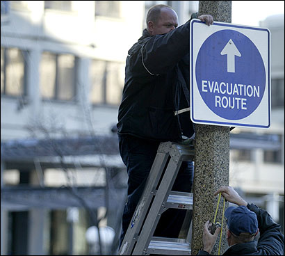
AASHTO might be a stiffer requirement on Comm Ave. because it carries US 20 into Kenmore. Not saying it isn't outdated or overkill for the purely urban context and that sane compromise amongst the willing isn't possible, but I think we may be forgetting that this is part of the U.S. Highway System. The 'keystone shield' routes don't have a minimum design standard like the interstates do, but there is a FHA expectation that new routes and big route makeovers substantially conform to AASHTO standards. And then you've got the state-level standards for numbered routes, which vary state-by-state. And then you've got the evacuation route designation which may or may not have some recommended AASHTO compliance preferences very loosely bound to Homeland Security funding sources for the city.


It's wide spread of wiggle room and very murky on interpretation so let's not be too dogmatic here on either extreme. There's probably room for compromise. But this is not as simple or clear-cut as a plain old BTD-maintenance city street or an unshielded DCR-control parkway. There are other parties indirectly in the mix thanks to this:

70px-US_20.svg.png
<-- 3,365 miles; longest road in the U.S., 5th longest in the world.

<--clicky for FHA details
 
Because of the characteristics of Comm Ave., with a large number of trucks using the corridor, the chance of 10' lanes ever being approved is highly doubtful.

Perhaps local roads shouldn't be optimized for large numbers of trucks?
 
Perhaps local roads shouldn't be optimized for large numbers of trucks?

Well, you need some sort of arterial road that is. They can't use Storrow and there aren't any ramps from the Pike. And there's plenty of things which need deliveries.
 
^ The other alternative is to switch out massive 18-wheelers for smaller trucks to make local deliveries.
 
^ The other alternative is to switch out massive 18-wheelers for smaller trucks to make local deliveries.

bingo. giant trucks should in most cases only venture into dense urban areas late at night.
 
Again, Comm Ave in the scope of Phase 2A already has 10' lanes, and has had them for a while now.

The 10' lanes do not preclude trucks. Let's not create our own myths.
 
Who is paying for the extra wide roads?

The difference would be everyone is able to use the roads (including trucks which pay taxes in the Commonwealth) where as only the freight carriers would bear the cost of switching to smaller trucks (which would be passed on to consumers to the extent possible). The point I was trying to illustrate is that nothing is without a cost, and it would be short-sighted to think that such a program could be implemented without any impact at all.

I think North Shore illustrated a variety of reasons why lanes are 12' and not 10', but if the only limiting factor is that 12' lanes are required for tractor trailers, then I would be more inclined to ask them to bear the cost of construction and maintenance associated with the wider lanes or bear the cost of switching to smaller trucks.

In general, I would subscribe to the notion that more revenue raised from user fees (gas taxes, highway tolls) and a corresponding lower amount of general revenues (sales tax, income taxes) would lead to better use of resources overall.
 
There's really no equivalent north-south arterial to east-west Comm, Beacon, Route 9 etc. Yet trucks somehow still find a way to get from JP to Cambridge, Rozzie to Arlington.
 
The point I was trying to illustrate is that nothing is without a cost, and it would be short-sighted to think that such a program could be implemented without any impact at all.

I don't think anyone was arguing otherwise.

There's really no equivalent north-south arterial to east-west Comm, Beacon, Route 9 etc. Yet trucks somehow still find a way to get from JP to Cambridge, Rozzie to Arlington.

A combination involving Washington Street and Mass Ave or 93 is the most likely route for north-south truck traffic. At any rate, I am sure they devise delivery routes so as to maximize the usage of the most truck-friendly roads, so you probably won't see many go directly north-south anyway.
 
To me, your logic is internally valid within the narrow confines of your rules and regulations. By beyond that it's a tautology. "We must do it this way because those are the regulations / Those are the regulations because we must do it that way."

Congratulations, you summed up the traffic engineering profession.

Circular arguments all day every day.

Again, Comm Ave in the scope of Phase 2A already has 10' lanes, and has had them for a while now.

The 10' lanes do not preclude trucks. Let's not create our own myths.

Nor do lanes that are 9.5 feet.

Philly is full of them. And yet SEPTPA buses and trucks manage just fine.

BUT THE STANDARDS MAN, THE STANDARDS
 
But you have to figure in the fact that Comm Ave is a coordinated corridor with the traffic signals interconnected and designed to ensure efficient traffic flow from one end to the other, including intersections with side streets.

No, I really don't, unless of course my priority is to "ensure efficient [vehicular] traffic flow" which it is not. You have made it clear that your primary and possibly only concern is that of the car, but personally I think creating a small bottleneck in order to allow literally thousands of students cross the street safely and efficiently is a worthwhile proposition.

If you find that troubling then of course the entire road's flow could gradually be slowed as it approaches the school to avoid a bottleneck. The math isn't very complicated. Hell, it may even convince some drivers to take the Mass Pike, or God forbid, even the T.
 
One thing that drives me nuts is the placement of the traffic signals in relation to the intersection. Many intersections are hazardous to pedestrians by design. In most cases, the signals really should not be on the other side of the intersection than the traffic they control, or at the very least, there should be one light lined up with the stop line. If the signal is on the close side of the intersection, at or near the stop line, cars will usually not block the crosswalk (this is done in Germany, among other places). If the signal is on the opposite side of the intersection, many drivers at many intersections will ignore the stop line and will drive into the intersection and block crosswalk, forcing pedestrian traffic in many cases to go into the lane of auto traffic on the cross street. For example: I've almost been hit numerous times by careless drivers while crossing from Franklin Square to the Silver Line stop at E. Newton and Washington Streets because many drivers pulling up to the intersection there are either unaware of, or ignore the stop line at that intersection. There is "No Turn On Red" sign there, so drivers have no business crossing the stop line when the light there is red.
 
http://www.bostonmagazine.com/news/blog/2014/10/16/mbta-green-line-stops-eliminate-discussion/

Your Green Line Commute May One Day Be Faster
Officials are talking about ditching some stops on the B Line. The trains will still squeak, though.

By Steve Annear | Boston Daily | October 16, 2014 2:41 pm

The MBTA is considering scrapping some of the stops along the Green Line’s B branch near Boston University to expedite riders’ commutes, and keep the trains from frequently stopping to pick up more passengers.

On Thursday, October 23, officials from the transit agency will meet at the Boston Public Library to go over a new plan to consolidate four stops along Commonwealth Avenue. According to details about the meeting, which will be hosted by Senator William Brownsberger and Senator Cynthia Creem, the proposed project would turn the BU West, St. Paul, Babcock, and Pleasant Street stops into two stations, providing faster travel times and improving rider safety.

“Green Line customers commonly ask if it is necessary for the trolleys to make so many stops along Commonwealth Avenue,” said MBTA spokesman Joe Pesaturo in an email to Boston. Asked when the T first started talking about consolidating these stops, Pesaturo replied “decades ago.”

As it stands, there are currently three stops dedicated to access to BU’s campus, followed by several additional stops in close proximity to those outdoor stations. Getting rid of a few of those stops along the B Line “would better serve the Boston University and Commonwealth Avenue community, as well as all MBTA customers in this very congested corridor,” according to a press release from Brownsberger’s office.

Brownsberger, who has been calling for vast improvements to the dilapidated and aging Green Line trains and service, said he was “grateful” that T personnel are considering the proposal.

During the meeting, transit officials with knowledge of the project are expected to present the public with cost and funding estimates, the 30 percent design of the eventual construction project, and the possible locations of the new stops. They will also be taking questions from those curious about the changes.

The meeting tailgates on the “Green Line Forum” hosted by Brownsberger and others, which was also at Boston Public Library, back in May.

If you go: Thursday, October 23, 6 to 8 p.m., Boston Public Library in Copley Square.
 
This has been posted in 3 separate places now:
Here, Matthew's meeting event thread, and the Driven By Customer Service thread

This discussion should probably just be consolidated into its own thread.
 
Would there be any advantage to combining these 4 stations into only one?

Also, would it be possible to combine Blanchard, BU East and BU Central into one or two stations?

If not, could BU ever purchase it's own trolleys and run them on these tracks as a BU shuttle?
 
Would there be any advantage to combining these 4 stations into only one?

Also, would it be possible to combine Blanchard, BU East and BU Central into one or two stations?

If not, could BU ever purchase it's own trolleys and run them on these tracks as a BU shuttle?

Way too far-spaced if you have fewer than 2.

Right now the station spacing goes (crosswalk access to crosswalk access):
Kenmore-Blandford: 1400 ft.
Blandford-BU East: 900 ft.
BU East-BU Central: 500 ft.
BU Central-BU West: 1900 ft.
BU West-St. Paul: 550 ft.
St. Paul-Pleasant St.: 750 ft.
Pleasant St.-Babcock St.: 750 ft.
Babcock St.-Packards Corner: 1000 ft.

Average: ~1000 ft.


So, clearly there's a lot of unevenness to smooth out. But swinging too far to the other extreme isn't a good idea either.

If you wanted the whole thing rejiggered into *ideal* spacing, this is probably how it should go:


Kenmore to Blandford: as-is, 1400 ft.

Blandford to BU East: as-is, 900 ft.

BU Central: *IF* the BU Bridge intersection is reconstructed to a single-point intersection, eliminate the Mountfort St. grade crossing for right-turns only at Mountfort and University Rd.; access to Storrow Dr. EB now goes by U-turn at St. Mary's St. Station placed at BU Bridge crosswalks. Delete old station. New spacing from BU East: 1600 ft. to BU Bridge intersection, 1200 ft. if you retain a ped grade crossing from the Mountfort/U. Rd. crosswalks to the other ends of the platforms.

"New" BU Central to St. Paul: Outright eliminate BU West (ped grade crossing can stay), no change in St. Paul position necessary. 1400 ft. spacing. Offset platforms on either side of intersection recommended, but the committee seems to want opposite mid-block platforms for some stupid reason.

St. Paul to Babcock: Outright eliminate Pleasant. No change in Babcock's position. 1500 ft. spacing. Offset platforms recommended because it's a busy intersection and offsets are best for signal priority, but committee will obviously ignore that. Moving Babcock to some mid-block thingy would be the stupid idea here that most disrupts the average spacing.

Babcock to Packards: as-is, 1000 ft.


Average spacing: ~1250 ft. Blandford-East is the short outlier (900 ft.), justifiable by Sox postgame crush loads and Warren Towers/CAS being the only logical location for maximum East ridership. Kenmore-Blandford, Central-St. Paul, St. Paul Babcock being almost spot-on the 1400 ft. range (+/- some crosswalk choices).


Assume for our purposes that a BU Bridge intersection cleanup clears the path to BU Central eventually relocating at a later date, because BU has desired that for a long time. I don't see why you'd want to mess with the configurations of anything else or do re-spacing for re-spacing's sake. "Consolidation" here really should mean "elimination" of West and Pleasant without touching anything else. And if the committee is looking for something more radical than that like mid-block compromises, it's probably going to be making it less efficient than if they left St. Paul and Babcock alone.
 

Back
Top