Crazy Transit Pitches

Which has more merit?

21598293042_4ce2365e60_z.jpg


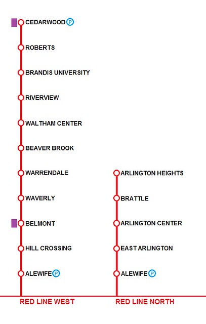
Cedarwood would be HERE, on the other side of 128, behind the Biogen complex. The Fitchburg line would have to be rerouted through Waltham along the old Central Mass ROW, reconnecting at the park-and-ride.

The whole ROW from Waltham to Hill Crossing was four tracks, although there has been some encroachment over the years.
 
Waltham should definitely stay as a CR stop - it's a small city of itself, a bus hub, and worth being a transfer spot. Cedarwood would also be a good transfer, but Belmont can probably flip to RL-only.

Was the ROW actually four tracks past the Central Mass split? I don't believe it was.
 
Is anything to be gained by adding an extension of the Orange Line to meet the Red Line at Broadway? (Using the DMU route and then going into the old Broadway tunnel now used for training.)

 
Waltham should definitely stay as a CR stop - it's a small city of itself, a bus hub, and worth being a transfer spot. Cedarwood would also be a good transfer, but Belmont can probably flip to RL-only.

Was the ROW actually four tracks past the Central Mass split? I don't believe it was.

Waltham would still have a CR stop, at the old central mass station site. You can't do CR and RT side by side through Waltham: the two ROWs are only two tracks. One has to be CR and the other red line, and the existing commuter rail makes more sense as the transit line.
 
Is anything to be gained by adding an extension of the Orange Line to meet the Red Line at Broadway? (Using the DMU route and then going into the old Broadway tunnel now used for training.)

Nope. You'd have to wind through a tangle of other tracks and highway ramps, possibly fuck up any chance of the NSRL, and get little to no benefit out of it.
 
There's really no other way to get up into Arlington (and even this will be nearly impossible with current reality) than using the Red Line and the rail trail. Meanwhile, Waltham works well as a bumped up CR once the track work is done, then as a bumped up DMU, then EMU, then N/S LINKED EMU FULL ON AWESOME SERVICE!!!111!!
 
Which has more merit?

I vote Waltham. On population and density alone, it competes or even has a slight lead. The kicker is that it would capture reverse commuters better and have all-day both direction passengers more than Arlington service.

Another benefit: I could take the Red Line to work!

EDIT: Also, there's an "e" in Waverley and Brandeis. Broken "e" key? :p

DOUBLE EDIT: I'd argue that in a perfect world, both extensions would happen. Headways would be perfectly suited with no short-turns necessary. Both branches demand about half the frequency as the Red Line trunk. Then, you could mix-and-match, or arbitrarily run Braintree-Cedarwood and Ashmont-Arlington Heights.
 
Which has more merit?

21598293042_4ce2365e60_z.jpg


Cedarwood would be HERE, on the other side of 128, behind the Biogen complex. The Fitchburg line would have to be rerouted through Waltham along the old Central Mass ROW, reconnecting at the park-and-ride.

The whole ROW from Waltham to Hill Crossing was four tracks, although there has been some encroachment over the years.

Waltham has more merit, but Arlington is more likely to happen. Go for Arlington.

Belmont NIMBY's are a bitch.

Let Green go down the Fitchburg someday after Red gets to Arlington Heights and Belmont NIMBYs shift to wanting their toy too. Green will likely end up in Porter relatively soon, and from there it's fairly simple to continue up the ROW.

If Belmont NIMBYs subside, the biggest obstacle could well be relocating the Commuter Rail to the Mass Central ROW. Abutters would probably make a stink about its reactivation and a new station nearby.

I've had lots of conversations with F-Line about extending HRT into Arlington. The catchment there is really driven by bus connections, and the politically feasible extension is just two stops: Arlington Center and Arlington Heights. Makes for some long distances between stops, but with the Minuteman running above/alongside the ROW there's a lot of direct path opportunities. The Lake Street crossing is not on Mass Ave and in the middle of three-deckers, which closely abut. Probably not a good place to get political support for a subway station. For Brattle, probably not a good place for a surface stop, between political strife and finagling the rail versus trail configuration.

EDIT: Anyone who wants to read (one) interpretation of how Red to Arlington Heights would go... I recommend posts 2737 and 2739 in this thread.
 
Last edited:
Another benefit: I could take the Red Line to work!

EDIT: Also, there's an "e" in Waverley and Brandeis. Broken "e" key? :p

Me too!!!

And it's just been a while since I've made a graphic... But I did it fast and in paint. Whoops.
 
Waltham's not a good Red candidate.

1) The tunnel already angles on the Arlington trajectory before dead-ending in the middle of Thorndike Field on the other side of Route 2. The amount of shit you'd have to blow up just past the Alewife platforms-proper and underneath the private parking garage across the street to realign the tunnel is a shitshow, and threading between all the new office buildings to get on-trajectory with the Fitchburg Cutoff ROW is a building mitigation nightmare. Simply getting the hell out of Alewife and on-trajectory with the Fitchburg Line is probably more expensive than building 100% of the Arlington Center tunnel under the Minuteman.

2) Grade crossings. Requires 5 eliminations between Blanchard Rd. and Brandeis to run heavy rail. And since the Fitchburg Line would have to be relocated over a reactivated Central Mass ROW past Beaver St. where the legacy mainline ROW no longer has 4 tracks of width, you're probably talking more crossing eliminations on the relocated RR to get a CM reactivation to pass muster with the town given how much density has crept up in since the line was abandoned in '87. So many of those crossings had piss-poor sightlines because of the CM's much poorer legacy design standards that you probably double the amount of total eliminations within the cumulative project cost.


Cost/benefit wise you'd have a waaaaaay easier time just bringing the GLX Union Branch out to Waltham from Porter instead. It would be totally on-alignment from the tail tracks at would-be Porter GL station, all of the lesser-concern grade crossings could stay, service levels can be throttled more variably on a branch to suit the lower density out there and keep all-hours operating costs from sailing too far out-of-line, and the GL definitely has the capacity to handle both this destination and a Watertown Square branch out of Porter if most peak service past Porter turns at Brattle Loop (Park St. isn't nearly as much an every-single-trip necessity if you're already hitting the Red transfer at Porter).


Keep it simple. You can get the same thing for $¾B less picking GLX instead of Red, while still keeping all options open for Arlington.
 
^ Prefer the Arlington alignment for all the reasons F-Line states.

My gut is that your Arlington stations are too close together.

Going with 5000' spacing, you'd end up with stations called:

Arlington Heights
Arlington Center West (High School)
Arlington Center East (Walgreens)
Alewife (existing)
 
Crazy Transit Pitch: resurrect the old freight track running alongside Cambridge Street. Extend it into a cut&cover tunnel up to SFR, then a bored tunnel to connect with the old Brattle Square tunnel. (I suspect single-level EMUs could be built to fit the old RL tunnel, though I'm not sure.)

Run EMUs: South Station - Back Bay - Yawkey - West - Stadium (build it under Ohiri Field) - Harvard.

Gives you all the benefits of a Green Line branch along a similar routing, without relying on the slow and overcrowded Green Line. Better access from Harvard to the LMA, Kenmore, and Back Bay, and a nice reliever for the Red Line. Even with the slow terminal segment, you could get it down to near 20 minutes running time - competitive with the Red Line during rush.
 
I suppose a tunnel and approaches allowing access to the Brattle tunnel would have to be built anyway regardless of mode.
 
Crazy Transit Pitch: resurrect the old freight track running alongside Cambridge Street. Extend it into a cut&cover tunnel up to SFR, then a bored tunnel to connect with the old Brattle Square tunnel. (I suspect single-level EMUs could be built to fit the old RL tunnel, though I'm not sure.)

Run EMUs: South Station - Back Bay - Yawkey - West - Stadium (build it under Ohiri Field) - Harvard.

Gives you all the benefits of a Green Line branch along a similar routing, without relying on the slow and overcrowded Green Line. Better access from Harvard to the LMA, Kenmore, and Back Bay, and a nice reliever for the Red Line. Even with the slow terminal segment, you could get it down to near 20 minutes running time - competitive with the Red Line during rush.

Going to have to address the overcrowded NEC and SS instead of the Central Subway, plus I'm not sure the demand will be there once EMUs are covering 4/6 of these stops going to Riverside. Definitely a cool concept, but it misses out on the B line improvements which would likely coincide with the GL to Harvard plans.
 
Crazy Transit Pitch: resurrect the old freight track running alongside Cambridge Street. Extend it into a cut&cover tunnel up to SFR, then a bored tunnel to connect with the old Brattle Square tunnel.

The freight track alongside Cambridge Street will be gone when the Mass Pike interchange is reconfigured.
 
Would it make sense to incorporate the urban ring concept into the NSRL? You could make an "inner loop" that starts at North Station, stretches down Storrow, turns at Hynes and continues to Mass Ave (OL stop), [somehow] get to South Station, and loop up to North Station. The "outer loop" would start at the airport, go through east Boston, Charleston, Cambridge, link with the inner loop at Mass Ave, and then stretch into South Boston/Seaport.

While building the inner loop section between north and south station, the NSRL link could easily(using the term loosely) be constructed, and the cost benefit of the urban ring could possibly add the needed value to the multi billion dollar NSRL.

I don't know much about this urban ring proposal and what the plan is now, but this seems to make sense to me.
 
^ There's a lot there...

The UR as planned (and really the only way it could possibly work) is as LRT. The was NSRL would work is as commuter and regional rail. So the two projects are (as planned) completely different modes.

If two of the possible four tracks in the link are reserved for rapid transit, it could potentially tie into an urban ring somehow... though I'm not sure how.

Your proposal seems to involve a Storrow Drive riverbank subway, which would require a major downgrading of Storrow. It also seems to involve a Mass Ave subway, which is just a non-starter.
 

Back
Top