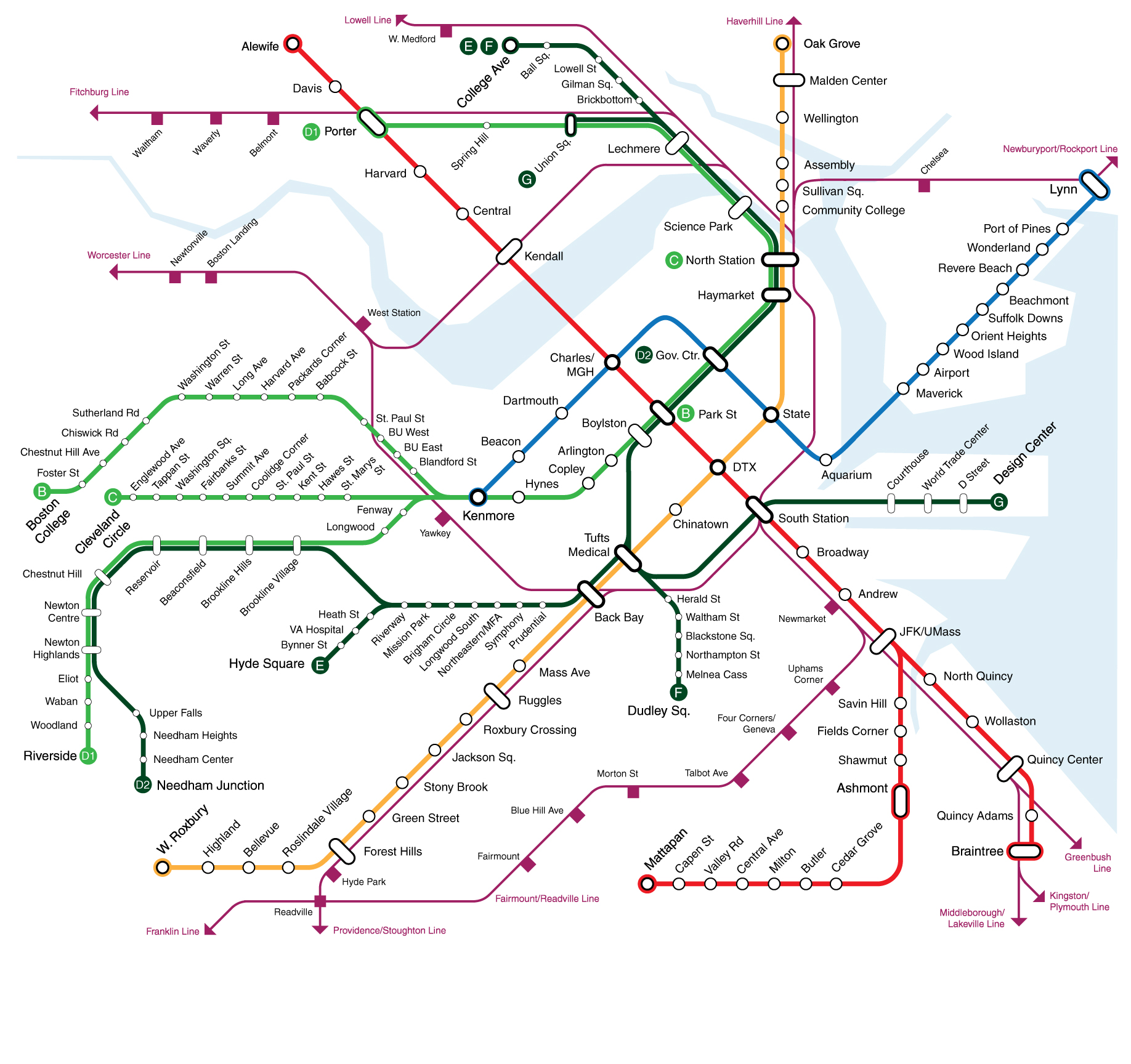
Crazy Transit Pitches

This would be the reference to bookmark for ID'ing those street corridors: https://en.wikipedia.org/wiki/Boston-area_streetcar_lines. And this: https://upload.wikimedia.org/wikipedia/commons/9/96/1925_BERy_system_map.jpg. Our old streetcar network. Most of the numbers still corresponding to bus routes today. Remember...we've always been a square-to-square travel patterns type of city...not a grid like Manhattan...so the Point A-to-Point B demand patterns really haven't changed very much at all and need almost no major philosophical re-think a la trying to impose NYC-style subway gridding on Boston's cowpaths-begat-squares. So little has changed, in fact, that the routes themselves follow almost exactly the same streets with exactly the same route numbers on the Yellow Line as they did on streetcars and horsecars before we ever built the subway. If it's not a New Boston neighborhood like the Seaport, history--not wild out-of-box reconceptualizing--is your guide.

Where we need to get back to basics is FREQUENCIES. The Yellow Line has to stop being a shameful stepchild. And the places where we do need rapid transit augmentation are simply frequency increases by a different and more capable mode. Sometimes requiring expensive steel-and-concrete and...yes, maybe some tunneling. And sometimes not needing more than a better-organized and suitable-to-task surface corridor. That's it. No need to re-draw the whole damn city out of Manhattan-on-the-brain when the city organically works and has always organically worked. Just fix the transpo frequencies and capacity that hasn't kept up with the times on these square-to-square patterns.


Bus routes (approx.) that used to run through the Central Subway (portals bolded):
92 -- Sullivan, Main St., North Station, subway (to 1949)
93 -- Sullivan, Bunker Hill St., North Station, subway (to 1948)
69 - Harvard, Cambridge St., Lechmere/North Station, subway (to 1922)
87 - Clarendon Hill, Broadway, Lechmere/North Station, subway (to 1922)
88 - Clarendon Hill, Highland Ave., Lechmere/North Station, subway (to 1922)
Silver Line -- Dudley, Pleasant St., subway (1938)
43 -- Egleston, Pleasant St., subway (1956/1961)
9 -- City Point, Pleasant St., subway (to 1953)
60 (partial) - Brookline Village, Huntington Ave./Boylston St., subway (to 1932; current 60 west of BV was out of BERy district, required transfer @ BV)
60 (partial) - Cypress St., Brookline Ave., Kenmore, subway (to 1932)

Note: that Dudley route on present-day Silver Line and the 2 Sullivan routes used to be matching subway pairs replicating the Orange Line El with denser streetcar stop selection.


Harvard Sq. bus tunnel trolleys (run-thrus to other subways bolded):
77/77A - Harvard, Arlington Heights (to 1958)
71 - Harvard, Watertown (to 1958)
73 - Harvard, Waverley (to 1958)
72 - Harvard, Huron Ave. (to 1938)
1 - Harvard, Newbury St./Green Line surface transfer (to 1949)
69 - Harvard, Cambridge St., Lechmere/North Station, subway (to 1922)
68 - Harvard, Broadway, Inman, Kendall, Charles Circle, Cambridge St., East Boston subway, Maverick, Jeffries Point (to 1919)


I won't list the Maverick/East Boston/Revere routes because the Blue Line extension replicated them pretty well, and all the Lynn/Chelsea/North Shore routes were out of the BERy district. We know how important Lynn terminal and the North Shore are to hit.


We don't have to think too grand here about firing up the TBM.

  • The 87 and 88 are well-augmented by building GLX.
  • Silver Line-Dudley should've been a GL branch from Day 1, and we can right that wrong any time we want by refurbing the Tremont Tunnel with a Tufts Med. Ctr. intermediate station.
  • The 43 gets its difference split pretty well flanked by Green to Dudley on one side and existing Orange on the other.
  • City Point gets re-enabled if we build the Green Line-Transitway connector connecting Silver Line Way to Boylston.
  • 92/93 get augmented by Green at both the Sullivan and NS/Haymarket ends by building out the Urban Ring. And, yes, a reanimated Dudley-Sullivan/Ring pairing would have a lot of demand.
  • The 60 variants are replicated by D-to-E connecting streetcar track allowing boosted Huntington Ave. headways via Brookline Ave. short-turns and run-thru options to Kenmore Loop. This also traces out a chunk of the SW quadrant of the Urban Ring (mode TBD), so could much later be subwayed if you can find a coherent way to do it.
  • Red-Blue serves up all the frequencies imaginable replicating that insane 68 routing from Harvard to Eastie.
  • Red Line to Arlington Heights rapid-transitizes the outer half of the 77 just like the Alewife extension did for the inner half.

Comb deeper still. . .

  • The 66 gets its load shifted around in a big way with the Urban Ring + Harvard spur.
  • Indigo-Riverside + a short 71 extension to Newton Corner super-sizes the Watertown-Harvard corridor.
  • Indigo-Fairmount + strengthened E-W bus frequencies strengthen the network effects in Dorchester.
  • Red to Mattapan + Green to Dudley + Indigo-Fairmount anchors both ends of the 28 corridor and allows you to dust off that 28X-Blue Hill Ave. proposal in a big way.
  • Look how clearly you can trace the SE quadrant Urban Ring on the 1925 map via Dudley, Southampton St., Andrew, and Southie/Seaport. That was even before the forces of urban renewal "gifted" us Melnea Cass Blvd. as an I-695 byproduct.


It doesn't change any of our build priorities, really, because the square-to-square travel patterns have been so rock-stable for >100 years. The only thing that's really been reshuffled is build priority order from modern congestion and development stressors. Otherwise, we know exactly what we have to do. GLX, Red-Blue, Downtown-Seaport, Urban Ring, the Indigos, the Crosstown buses, the two-seater frequency boosts.

The only two big desireable links we can't really build are:

  • That Mass Ave. subway under the 1. For many, many cost, climate change, and geological reasons.
  • A Lechmere-Harvard connector uniting the Green Line with the Harvard bus/trolley tunnel & routes. Was briefly considered up Cambridge St. via Inman 100 years ago and would've changed the face of the system, but never quite came together. Would've been nice to have an Inman subway station, but given all we're capable of triaging via the Urban Ring, UR Harvard spur, and taking GLX through Porter we're never going to be at a loss of new and incredibly useful ways to link pieces of Cambridge together via other corridors. This simply isn't an omission worth getting hung up about while Allston-Harvard so badly needs a link and Porter still beckons the Union Branch (nevermind far-future possibilities past Porter on the Watertown Branch augmenting the 70 & 71).


...and then there are some obvious concessions like no Washington St. grade separation because we stupidly blew up the El and tunneling's too disruptive, and the southern-half Urban Ring not having a street grid suitable for tunneling through Longwood. Tactical nuclear strikes for perfectionism's sake just have to take a knee here for 50-75 years until we get all critical moving parts of other megaprojects done first.
 
F-Line(or anyone else interested), if you'll humor me, allow me to pose this addendum:

Again setting geology aside, you have the opportunity to bore a new subway tunnel for the city, but it has to follow under one of the existing lines. What line receives this addition?
 
I would nominate a deep bore tunnel under the Green Line from Watertown Square (following the old A Line route) then continuing under Comm Ave by BU, and under the Central Subway and Charles River to Lechmere. This new tunnel would be for heavy rail cars, not LRVs.

The result: vastly increased capacity and quality of service for this key corridor, while preserving the existing LRV tunnel for the Green Line branches to use.
 
F-Line(or anyone else interested), if you'll humor me, allow me to pose this addendum:

Again setting geology aside, you have the opportunity to bore a new subway tunnel for the city, but it has to follow under one of the existing lines. What line receives this addition?

I would vote for the Red - if only because this would allow for the curve at Harvard to be corrected, cleans up the mess at JFK, and allow the Braintree branch to be underground which has caused oh so much trouble in the snowy months. Just seems like it would make the Red much more reliable and faster (with the speed restrictions lifted). Green line is a close second, but not sure for this exercise if we could sink the entire thing, or only one line of it. If we can do all of it I think it actually leap frogs the Red, but if its only one line than, meh, Red wins. Well, for me at least and I have a bit of bias taking the Red everyday. Blue seems fine and to be honest the most reliable line already, and the Orange is mostly buried anyways, it just needs a roof over it.
 
I would nominate a deep bore tunnel under the Green Line from Watertown Square (following the old A Line route) then continuing under Comm Ave by BU, and under the Central Subway and Charles River to Lechmere. This new tunnel would be for heavy rail cars, not LRVs.

The result: vastly increased capacity and quality of service for this key corridor, while preserving the existing LRV tunnel for the Green Line branches to use.

I agree for the most part. However I would push the subway out to Waltham. A park and ride or a new 128 park at the end of the line could also be a possibility.
 
F-Line(or anyone else interested), if you'll humor me, allow me to pose this addendum:

Again setting geology aside, you have the opportunity to bore a new subway tunnel for the city, but it has to follow under one of the existing lines. What line receives this addition?

Sorry...you have to humor us first as to what's with the hyper-focus on DEEP BORE MOAR SUBWAY! because reasons. "Let's dig shit to say we can!" isn't a Transit Pitch. It says nothing about what demand for mobility is served.

I ID'd what the demand corridors are, using the historical evidence that says the demand corridors have always been what they are. If you can't find discussion fodder in that, you're barking up the wrong tree asking for a Civil Engineering Strongman competition in a vacuum. We talked at length a few pages back at what the difference is between Crazy that's a real Transit Pitch and Crazy that's just Crazy for Crazy's sake. It's not a transit pitch if you don't pitch it from somewhere with established demand that solves a real-world problem with moving that demand.

Its a thought experiment, nothing more.

If you want more anchoring to real world considerations, I'm interested in the ability to have redundant/express tracks, which would enable better reliability and imprive ease of maintenance.

Again, just a thought experiment directed at someone who clearly knows what he's talking anout.
 
I wouldn't do an "under" on any existing line. I'd rather bore:
1) The NSRL
2) North Station to Kenmore under Storrow
3) Any section or segment of the Urban Ring.
 
Yeah more interested in resilience at the network level than redundancy at the line level
 
Its a thought experiment, nothing more.

If you want more anchoring to real world considerations, I'm interested in the ability to have redundant/express tracks, which would enable better reliability and imprive ease of maintenance.

Again, just a thought experiment directed at someone who clearly knows what he's talking anout.

Well, I addressed that too with the streetcar post. We aren't a city of gridded travel patterns, so the express vs. local tracks organization that Manhattan uses isn't all that applicable to a city that's organized square-to-square, and then becomes a hub-and-spoke system once you zoom out to a more macro level than the squares.

Sure...it'd be neat to have >2 tracks across the Red Line. But how exactly would you run a NYC route pattern on it? Skip Kendall? Skip a downtown transfer? Skip future Red-Blue @ Charles or Urban Ring @ Broadway? How would you possibly divvy up such a continuous bloc of demand among different one-seat fixed routes and keep the route map coherent? It's not going to work like Manhattan...because we're not organized like Manhattan.


The thought experiment IS the old streetcar map and what you can usefully fashion out of it in the 21st century. Not trying to apply Manhattan here. Square-to-square, hub-and-spoke. Through-the-CBD and radials. This thing, this thing, this thing, this thing conforming to the squares-to-squares, hub-and-spoke organization. And better, more frequent, more flexible buses already aligned to that organization.


What does any of that have to do with MOAR TUNNEL? Nothing. It's demand patterns unique to greater Boston. Find a demand pattern unique to Greater Boston that needs a tunnel (as opposed to TBM Strongman Competition for time-waster's sake) to be adequately served, and there's something to talk about. There's nothing to talk about with boring tunnels in a vacuum or Manhattanization of a grid that's not Manhattan. That's not a thinkpiece, it's non-reality. Find demand that exists in reality, then posit a solution. That's what makes it a ____ Transit Pitch.
 
I wouldn't do an "under" on any existing line. I'd rather bore:
1) The NSRL
2) North Station to Kenmore under Storrow
3) Any section or segment of the Urban Ring.

I agree with all of this. If you are going to invest in deep bore tunneling, this is where the investment should go.

I would probably put 3 above 2, particularly to solve the south side Urban Ring connection issues.

Any maybe a:
4) Tremont Green Line portal to Silver Line transitway, some portion of the connection may need to go deep bore to avoid buildings.
 
The synthesis of the argument here is to complete the subway tunnel planned in the 30s - heavy rail-ization of the central subway and the b branch with a tunnel under comm ave west of kenmore. Maybe it doesn't need to be underground after union square allston.This seems the biggest gain.
 
This may or may not be considered crazy in the long run, but what are the implications of removing Storrow/downsizing Storrow? Direct effects? Pros/cons?
 
Been discussed here lots in the past. Whether or not it would result in carpacolypse seems to hinge largely on whether the Pike can be retrofitted to duplicate what Storrow does, which, right now, it doesn't. Pike would need new eastbound entrances and westbound exits in the Back Bay, for example, to take this role. Also, in Allston, the new interchange may make it somewhat easier for drivers to easily move from the river roads to the Pike, so that's also going to make the Pike a more attractive alternative than simply staying on SFR/Storrow.

On the whole, I believe it would be tremendously beneficial to downgrade Storrow and open up the Esplanade from the Back Bay and Beacon Hill. There's also been talk here of running the Blue Line from MGH in a box tunnel along this ROW to Kenmore, which would be a huge benefit in itself for taking pressure off the Green Line.
 
I agree. Some concepts for Pike ramps have been presented on here, which are feasible now with electronic tolling. The State also came out with some, not as good as the ones on here.
 
I know there have been various discussions of running the commuter rail on an RE/S-bahn type service pattern, especially if NSRL ever happens. Having paid a relatively recent visit to Germany I've been thinking of how this might look. I present the following for your consideration:

0gNZrPc.png


(Built off this map originally created by The Port of Authority)

Some notes/assumptions:
*I have things set up with only S-bahn (~inside 128) type services running through the NSRL, but you could definitely pull some of the CR lines into their opposite terminals as well (e.g. Providence <-> North Station).
*I'm assuming that Needham gets cannibalized by OL/GL extensions. I'm keeping the lower western route as an S line, but this could also get sucked up by an OL extension. Likewise, West Lynn/Riverworks could be cannibalized by a BLX.
*I didn't include all CR extension proposals (RI infills/expansion, Nashua/Manchester, Plaistow, etc). I did include SCR as it was already on the base map.
*I'm somewhat ignorant of what north/south pairings make the most sense, so the S destination pairs are pretty arbitrary. I also kept the current structure of branches vs. lines (all of the OC lines are branches, Lowell/Haverhill are distinct lines), but maybe every terminal should have its own number.
*Some station changes: More infills on the inner Worcester Line, Hastings + Kendal Green get eaten by a 128 superstation, Mishawum gets switched to a Montvale station, West Lynn + Revere infill on the Rockburyport. North Wilmington gets lost by running the Haverhill trains on the Wildcat; might be worth reopening the closed station at Salem Street as compensation.
 
495-to-128 mainline routings are where the peak schedules would most pair up so any given region's job market has access to the employment centers on an opposite (i.e. hardest to commute to) quadrant of 128.

So...for example, Mansfield is the busiest intermediate stop on the whole system and an extremely high-profile 495 stop. The hardest-to-reach jobs in Greater Boston for a commuter on the Mansfield stretch of 495 are the ones polar opposite to Westwood/128 station in the Burlington-Woburn stretch of 128. Those commuters get their biggest boost in economic mobility being able to run thru to Anderson RTC, then catch a 128 biz shuttle out of there (with network effects bumping bus frequencies, yada-yada...). In the opposite direction people from Lowell, Billerica, and Wilmington are most out-of-reach of the Westwood stretch of 128 and would have highest economic gains with their peak-hour trains terminating at Westwood and buses fanning from there.

You can extrapolate from there. MetroWest and North Shore are high-profile polar opposites. South Shore and Waltham. Little more imperfect a match with Norfolk & Bristol Counties vs. Middlesex & Essex. And obviously capacity and pair-mismatch issues are going to overrule geographic perfection. But you get the picture. That's your general organizing principle for the pairings, and it's going to be cleaner to keep the pairings all-day consistent except for when there's a capacity or slotting mismatch that forces a changeup.

Outer branchlines obviously are going to disproportionately take up the surface station slots because of more diffuse pairing demand and tougher dispatching; aggregately those commuters get better frequencies working the transfers. Super long-hauls obviously have extremely little real-world demand for thru-and-thru and become a staffing/equipment cost burden and OTP headache at 100+ miles, so no Wickford-Concord, NH runs; those are going to terminate at the surface. Surge slots are going to terminate at the surface for sake of keeping the pair rotation through the tunnel consistent and non-chaotic. And you're going to have to do some dynamic number-crunching when it comes to regional intercity like Providence-Lowell or how far up the North Shore to push a Worcester-originating run, because reverse-commute demand's going to be very time-sensitive to jobs and a little askew with the CBD's conventional "rush hour" because of the extra running time. For these reasons it'll be impossible to depict the non-Indigo pairings on a spider map because the terminating stations and how many Zones out they go are going to be thrown in a blender on the schedule. Just keep in mind that by and large it's going to be all-day consistent which mainlines pair up, and not the "everywhere to anywhere" anarchy of that misleading graphic on the NSRL .org advocacy website.


For the Indigos. . .


  • By geography, ridership/demographics, network effects from thick bus connections, and mainline capacity Worcester Line and Eastern Route are a hands-down match. So "S1" is going to be a permanent Riverside-Peabody pairing (note: Town of Danvers dropped out and went rail-trail, so that terminus is North Shore Mall/128 in Peabody where they're still loud advocacy). Because the layer cake of overall services on both the Eastern and B&A are overall so dense it'll probably only be S1; neither Peabody nor Riverside have enough bandwidth to absorb another Indigo route enough of the time. Some of the time, sure, there's be an alt-pairing grabbing the occasional open slot. But for cleanliness of wayfinding's sake you probably just want to make that spider map pairing S1-only.
    • Keep in mind also that since there can never be rapid transit built along the B&A/Pike corridor, rapid transit relief in the form of Blue Line to North Shore (even a later Lynn-Salem extension) becomes a perfect complement to this Indigo pair. There'll always be separate and distinct demand patterns between Salem-Lynn-Eastie-CBD and Salem-Lynn-Chelsea-Allston-Newton, driven by the frequency-enhanced network effects of all the bus transfers en route.


  • Note that you will not ever see the Fairmount Line terminate at Westwood Landing. The need to re-engage Amtrak dispatch at Readville Jct. is going to short-circuit enough 15-min headways when an Acela or NE Regional gets priority at the junction that you'll have periodic all-day hiccups. It's a problem if you were thinking Westwood today, Westwood in 2040 with NEC FUTURE service levels, or Westwood with the NSRL. So swap the "S2" terminus with Endicott + Dedham Corporate under a single T dispatcher where the all-day frequencies are guaranteed. If you're keeping the Reading Line, S2's a geographic match for Reading.


  • Fitchburg Line is the single most under-capacity line on the system, and because of the freight mainline on the outer stretch it'll always be limited to 'conventional' peak/off-peak schedule past Littleton short-turns. Therefore Waltham & Littleton become pretty much the dumping ground for absorbing every pairing mismatch. Geographically Waltham/S4 is a perfect match for the Old Colony...but the Old Colony will never ever have full-on Indigo headways everywhere even if the Dorchester single-track got fixed. Parts of Quincy will be single-track forever, and it has 3 full-schedule branches to feed including super long-hauls to the Cape. I would say half-hourly all-day service to Brockton is feasible, and probably should be paired with Waltham. But only big, dense Brockton and the BAT bus terminal; too much of a reach to include South Weymouth. So that leaves Waltham/S4 short on slots. Forking some Fairmount S2's out there could pick up the slack, so that can be one place (maybe the only one) where a double-up could work.

Leaves a big problem elsewhere, though, since it's a 4-on-2 mismatch in Indigo schedules north vs. south. SW Corridor is off-limits because of Amtrak priority, and Old Colony can only take a half-Indigo schedule. Despite NSRL there's still *a* capacity ceiling on the mainlines. Fairmount can't outright x2 its Indigo schedules because it'll be running all Franklin/Foxboro slots booted off the NEC, and Riverside can't outright x2 its schedules because the B&A schedule layer cake is so thick. What are our options?


  • You already have pretty dense Westwood-Anderson service via the NEC-NH Main pairing and its associated 495-to-128 tunnel slots, and would be grouping in Haverhill + Stoughton/South Coast pairs for symmetry. Maybe that means you don't do a 'fixed' Indigo route to Anderson at all and just weight tunnel slots for the 495-to-128 schedules so you get a de facto Anderson-Westwood route fashioned out of the Providence/Lowell/Stoughton/Haverhill frequencies? Maybe not 15 min. frequencies on-the-button guaranteed but +/- 3 mins. of 15 averaging out to 15 over the course of an hour. Depends on how big a stickler you are for "15 on-the-button" frequencies being Indigo's defining characteristic. But I'd go ahead and make Anderson-Westwood a map pair because on-the-ground reality is good enough.


  • That leaves the executive decision on Reading. If we really want to go full-on Germany for fixed-route cleanliness, it's the odd man out. It almost certainly is going to work best and keep its mission statement best as a geographic pair with West Roxbury flying under the Orange flag. Ditto to lesser extent an Arlington Heights extension of Red so Braintree has a little symmetry to compensate for the limitations of the South Shore/Old Colony vs. Northwest pairing. By so thoroughly rebooting the system NSRL does create new inequities that can only be corrected by other modes, and does shift load around in ways that can only be brought back into perfect alignment by other modes. Anyone buying the line that "Indigo = rapid transit" like it's a cure-all is mis-applying the moniker as badly as "Silver-painted bus = rapid transit". It's a second system...and where the system is incomplete or broken somebody's going to get screwed without a follow-up solve. That's the predicament the Needham Line is in with the Amtrak "second system" gobbling up all its slots, and why the feds/NEC FUTURE has to work with the state on a solve for that. And that's the predicament Reading's going to be in with NSRL (as well as to lesser extent the weak SE/NW pair coverage).

Beyond-scope of your map, but these network-effect considerations go way, way deeper than tip of the iceberg so the solutions to that 4-on-2 Indigo mismatch are going to be front-and-center, very multimodal, and a challenge to our fearless leaders for how total a transformation they really want to commit to.
 
I know there have been various discussions of running the commuter rail on an RE/S-bahn type service pattern, especially if NSRL ever happens. Having paid a relatively recent visit to Germany I've been thinking of how this might look. I present the following for your consideration:

0gNZrPc.png


(Built off this map originally created by The Port of Authority)

Some notes/assumptions:
*I have things set up with only S-bahn (~inside 128) type services running through the NSRL, but you could definitely pull some of the CR lines into their opposite terminals as well (e.g. Providence <-> North Station).
*I'm assuming that Needham gets cannibalized by OL/GL extensions. I'm keeping the lower western route as an S line, but this could also get sucked up by an OL extension. Likewise, West Lynn/Riverworks could be cannibalized by a BLX.
*I didn't include all CR extension proposals (RI infills/expansion, Nashua/Manchester, Plaistow, etc). I did include SCR as it was already on the base map.
*I'm somewhat ignorant of what north/south pairings make the most sense, so the S destination pairs are pretty arbitrary. I also kept the current structure of branches vs. lines (all of the OC lines are branches, Lowell/Haverhill are distinct lines), but maybe every terminal should have its own number.
*Some station changes: More infills on the inner Worcester Line, Hastings + Kendal Green get eaten by a 128 superstation, Mishawum gets switched to a Montvale station, West Lynn + Revere infill on the Rockburyport. North Wilmington gets lost by running the Haverhill trains on the Wildcat; might be worth reopening the closed station at Salem Street as compensation.

Great map! I guess my only initial suggestion would be to extend R3 up to Nashua, MHT, Manchester, and Concord--all in NH. The state would like to have commuter rail service to Boston
 
So...for example, Mansfield is the busiest intermediate stop on the whole system and an extremely high-profile 495 stop. The hardest-to-reach jobs in Greater Boston for a commuter on the Mansfield stretch of 495 are the ones polar opposite to Westwood/128 station in the Burlington-Woburn stretch of 128. Those commuters get their biggest boost in economic mobility being able to run thru to Anderson RTC, then catch a 128 biz shuttle out of there (with network effects bumping bus frequencies, yada-yada...). In the opposite direction people from Lowell, Billerica, and Wilmington are most out-of-reach of the Westwood stretch of 128 and would have highest economic gains with their peak-hour trains terminating at Westwood and buses fanning from there.

I guess my thought in only running S-trains (and presumably some Amtrak) through the tunnel is that it makes the dispatching a bit simpler and keeps the need for wire-stringing inside 128. Also, the thought was that if S/RE transfers were timed well that a Mansfield-Woburn commuter could have a relatively easy 2-seat ride, which is still a significant improvement over the current situation. But maybe I'm being too OCD about keeping the (lighter) purple trains on the surface.

By geography, ridership/demographics, network effects from thick bus connections, and mainline capacity Worcester Line and Eastern Route are a hands-down match.

North Shore <-> Riverside it is. And likewise on only fitting on flavor of Indigo on the inner Worcester; I knew I was being a bit ambitious there. I kept Danvers/128 ambiguous to allow for either routing, but was actually envisioning the mall routing when I was making the map. This is another thing I was trying to do - end all the Indigos at 128 parking sinks. Hence Westwood...

Note that you will not ever see the Fairmount Line terminate at Westwood Landing.

I figured this was a stretch, but as stated above I wanted a parking sink. Dedham Corporate would be a suitable replacement, but if we're going to head down the Franklin Branch I would propose going all the way to Norwood Central. Between the wider ROW and the Wrentham branch stub, I would imagine there's more space to layup trains between runs while staying out of the Franklin line's way. Plus, it feels a bit unkind to Norwood to end frequent service immediately outside their borders.

So...looking it over, maybe run Lowell/Providence trains through the tunnel and eliminate the S3 as it currently exists. As you noted, with Haverhill and Lowell schedules sharing south of Wilmington the inner Lowell line will be reasonably frequency-dense as it is. Then giving the Western Route over to the Orange Line fixes the 4-on-2 mismatch. That leaves a Riverside<->Peabody S1 and a Norwood<->Waltham S2. Add a half-frequency S3 Brockton<->Waltham to fill out the inner Fitchburg?
 
Yeah...that would work. The 128-to-128 Indigos are a bit more cut-and-dried, so those are all clean and logical pairings. For all else we're still dealing in nebulous concepts because the 495-to-128 matchups are so very very speculative and we haven't even begun to attach numbers to them in a way that gives any hint of schedules or priority. And, same as if we Indigo'd today, some of those "once every 15" slots are going to be occupied or augmented by a 495 local making pick 'em of the same Zone 1A/1 stops when those interlopers get their slots. There's nothing requiring rigid segregation of trains when a trip intra- 1A/1 costs the same and goes the same places on an any-vehicle. We're not dealing with a 100% hermetically sealed system like the Red Line; shared-use is a fact of life on mainline rail, and as long as the fare structures are portable it's silly not to use that sharing for every ounce of +1 service it's worth. For that reason it's fully simpatico to fashion a 'close-enough Indigo' out of the NEC+NH Main pairing so long as the dispatch dance evens it out to more-or-less league average Indigo frequencies over the course of every 60-90 minute snapshot of the service day.


For Brockton since that's got a more spaced-out schedule and a justifiably higher Zone fare for the extra distance you could maybe differentiate it from the other three by making it a named train instead of S# moniker. I don't know, something jazzy like "The BAT Express". The bus connections and associated network effects are going to be the main attraction for that trip; Waltham's a sizeable hub, and BAT's got an extremely well-distributed route map that fans out like a spider web anchored by the Stoughton Line to the west, Plymouth Line to the east, and hub dead-center @ the downtown Brockton stop on the Middleboro Line. It's an excellent pairing for 2-or-more seat trips involving a bus given what's featured at the end hubs, so should be part of the mix. The Old Colony just has way too many mouths to feed for it to be a full-on "once-every-15". And, honestly, that probably has less to do with solving every last foot of single-track in Quincy than it does the OC being the system's only permanent tri-branch, equal-time, 495-oriented main...with one of those branches also tasked with doing long hauls to the Cape.
 

Back
Top