Is this the first time that BLX-beyond-Charles appeared in any documents other than crayon maps?Boston Planning & Development Agency planners, as seems to be their wont (sorry, folks - if the shoe fits...) threw a bunch of wild-eyed, long-term transit visioning into the latest East Boston rezoning study, including this crayon of alternatives for extending the Blue Line:
View attachment 42553
FYI: If you see the map in context (page 87 of the PDF, 169-170 of the printed doc: https://www.bostonplans.org/getattachment/64e6e176-1936-46e7-abb2-bf131fdca6fe), it's clear that crayon is options, not a vision for an octopus-like line.
Other notable ideas and/or intent expressed about use of streets in the area:
**Wouldn't that run afoul of the vehicular access detailed in the 355 Bennington St. project presentations from last year? https://www.bostonplans.org/projects/development-projects/355-bennington-street
- advocating for using the 1A corridor as some kind of additional bus highway and adding Revere<>Eastie<>Chelsea bus service (PDF pages 80-83)
- Redrawing Day Square to put the SL3 and T104 on dedicated surface lanes (PDF pages 51-53)**
- Fairly lengthy bus lanes up Meridian (PDF pages 45-50)
- A whole mess of cycling improvements (scattered throughout, PDF page 34 and onwards)
Is this the first time that BLX-beyond-Charles appeared in any documents other than crayon maps?
Although I think this would be amazing, and there definitely are examples of such tunnels elsewhere, a really good interim solution would be expanded ferry service. At a minimum, it shouldn't be seasonal, but better frequency would also be great. The ferry transformed my commute to East Boston over this past year, and the only real issue is that I have to be sure I arrive before it leaves, because missing it means waiting 30 minutes for the next boat. In practice, that adds 10-15 minutes to my commute, because I'm not willing to risk missing it.The last page says we should consider a dedicated bike/pedestrian tunnel from East Boston to downtown, and... I'm not even going to criticize that. It sounds awesome and we should do it.
I believe a blue line extension was officially considered as an alternative in the early stages of planing for the project that ultimately became the GLX.Is this the first time that BLX-beyond-Charles appeared in any documents other than crayon maps?
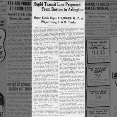
This captured my imagination since I hadn't seen it before, so I sketched it out (using a stylus, so it's a little wobbly in places).There was a 1924 city study for an extension to Charles in conjunction with the construction of that station, and a 1926 proposal (part of the region's first comprehensive plan) to connect it to the Tremont Street Subway at Park Street and run through out Comm Ave. There was also a 1938 proposal by the Somerville mayor to extend the line to Arlington via Lechmere and North Cambridge:
Article clipped from The Boston Globe
Clipping found in The Boston Globe published in Boston, Massachusetts on 12/29/1938.www.newspapers.com
This captured my imagination
Looks accurate, except the BL probably would have crossed Fresh Pond Parkway to the north of the Route 2/16 intersection. using a RR ROW that used to connect to the Lexington Branch:This captured my imagination since I hadn't seen it before, so I sketched it out (using a stylus, so it's a little wobbly in places).
View attachment 42690
A reminder -- as ever -- that probably something like 80% of Crazy Transit Pitches -- past and present -- are just a matter of connecting together the 19th-century ROWs in novel combinations.
MassDOT has begun the process of planning a replacement for the 73-year-old Tobin Bridge, one of the largest bridges in New England and a major regional connection for the greater Boston region.
"Repairs are not a permanent solution, that's why we are releasing the (request for proposals)," said Tibbits-Nutt.
Go under not over the channel.Some super-quick math (~250 feet tall, ~3500 feet of travel from first channel to underground segment of the roadway) shows a grade steeper than any on the MBTA system: 7% versus about 6.5% on the Causeway Street Tunnel up to the Lechmere viaduct. That doesn't bode well for anything other than BRT.