Fantasy T maps

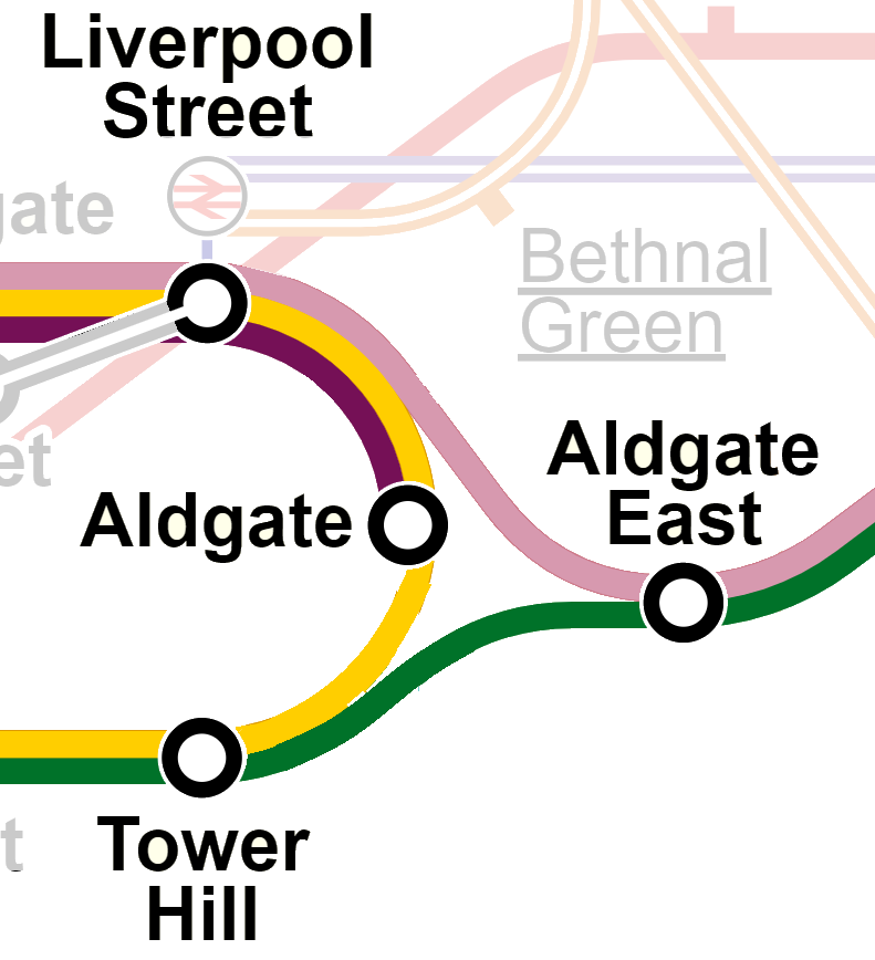
Today’s post gives a name to a kind of transit system topology that is somewhat common but doesn’t have a specific name. I have coined it the “Aldgate Junction”, named after the junctions at Aldgate on the London Underground:
z71gSw3Rawyd02Z1j51oQ8MlE146dlLw8oYwxqe063bl8JUyC3KH-q31yG9CEPi4dwnv0QYyXBGxtqHBDyBBuCzang08klrc8f4NRsp4v-erpv3eNrG7vUhUA-gu1HSD35_K0KSd9Mp9JTDcEg


Aldgate Junctions both complicate and simplify. On the one hand, they enable a larger variety of one-seat rides and increased frequencies on branchlines. On the other hand, they entangle all affected branches into one big complex service, which can impact reliability and sometimes can ultimately put a cap on overall capacity.

We’ve talked a lot about Aldgate Junctions over in the Green Line Reconfiguration thread (where I’ve put some additional comments specific to those proposals). Boston doesn’t have too many other Aldgate Junctions (although we once did – stay tuned for another post on that). Beyond the possibilities on an expanded Green Line network, probably the two best-known examples are both on the commuter rail network.

On the southside, we have the South Cove Loop, which connects the NEC and the Fairmount/Old Colony Tracks. Every so often, someone suggests using this to run trains from Fairmount or Old Colony to Back Bay and Allston or Newton. This is a case where insufficient infrastructure exists to make a functional Aldgate Junction: the loop track only connects to the southernmost track of the NEC, requiring trains for Allston/Newton to cross almost every single other track before reaching Back Bay, which would block off multiple tracks and impede the much higher priority traffic between Back Bay and South Station.

On the northside, we have trackage near the erstwhile Boston Engine Terminal, which connects the Fitchburg Line to the B&M routes at Sullivan Square. (Technically, these tracks were part of the original Grand Junction Railroad, though nowadays we often use that name to refer solely to the segment between the Fitchburg Line and the B&A Line in Allston.) These tracks would enable trains to run from the Fitchburg Branch to either the Reading Line or the Eastern Route without hitting North Station. In some far hypothetical future, I could possibly imagine a Waltham-Lynn RER service leveraging these tracks, but for the foreseeable future, this seems unlikely, as slots on the Eastern Route will need to be devoted to the much more valuable North Station destination.

From a mapping perspective, Aldgate Junctions pose interesting challenges. Today’s Tube map (as shown above) uses three different colors for each “leg” of service across the junction: yellow for the Circle, pink for H&C, green for the District. But different strategies have been adopted in the past. (All examples below drawn from https://www.clarksbury.com/cdl/maps.html)

In 1933, the Tube used purple for both the northern legs, and maintained green for the southern leg, and showed the purple just sorta mysteriously merging into the green lines. This reflected the heritage of the services as separate railroads that shared each other’s tracks.

guQIrdxl-Z56PXzed37p06GJwoPW7lsMAJroz-xKNWeg5ttcO6E4ez0I3UEKIYutcDt7Qg9n9CdkaXSCApmEHxPQJL3AAweDpp2Q93PTJpMdrzHDo5X0_6Ru5viAxGVHNWRsq3wslKLeH85jIP0

The New York City Subway also uses a similar “2+1” solution for most of its Aldgate Junctions, where two legs are conceptualized as “branches” of a single core service, and a separate line identity is used for the bypass.

Keen observers will note that just to the east of the Aldgate Junction, another line appears to branch off of the green District Line, leading to the East London Line. The ELL was at various points considered part of the Metropolitan Line, and was at various points colored accordingly, such as in 1958 (even though direct services were not running between the ELL and the rest of the Met at that point):

FgDEhjn535a3QFwbZgzpVnpdUTjUEVlQFa1HJL2neuiVi8p8W_huhWLathsmo1u3VCfqgVSpGNoeCS9DEvOuZWVRsLqYEZEVVt4wAyh82NToVTlEeoUJjgvLWYiX-42p-NxIefTo3ZbEhPnszqw


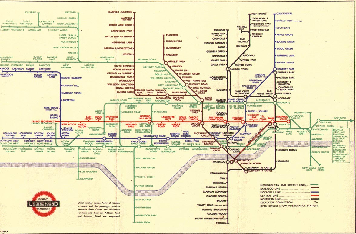
But in earlier years, when direct service was run from Algdate East on to the East London Line, the division between “purple” Metropolitan services and “green” District services was not so clean. And so it’s unsurprising that 1940s Tube mapmakers just threw their hands in the air, and colored the whole thing – Metropolitan and District lines – a single green, stretching from Aylesbury to Upminster and encompassing… 15 (?) branches! See for example this map from 1945:
nk0Lxhsb6DyKlK0LxxhF1ntDtefIieJi7XtJTQknHouXiJooK8xCt_3qr5chUhuLVD8KVlVJdUH0KKCQsR4_nY8Dc6wZ-fZd58qOmz37DbuKEf6dJK6HDSY5vmuCqHPcZWnizeiW37Wov4E0UWs


The “one color” approach seems less-than-ideal to me – you’re basically telling riders, “Yeah this is complicated, you will need to do more research before traveling.”

(This map has one more Aldgate Junction hidden in there – bonus points if you can find it!)

An Aldgate Junction is essentially a wye junction that is robust enough to handle full revenue service on each leg. While this may suggest that the term is redundant, I argue it’s worth distinguishing: wyes are often used for non-revenue service and often are built accordingly. The South Cove Loop is a good example: it’s useful for limited train moves as needed, but it can’t be scaled up. Moreover, historically in North America wye junctions are much more commonly used for turning equipment – indeed, most of the examples listed in the linked article are for that purpose.

These really are very different, therefore, in both use and character from something like the Oakland Wye, which is an enormous three-way flying junction that sees nearly every BART train passing through – something like 40 trains per hour across all branches in all directions. (That’s a train every 90 seconds!) So, I argue, it’s worth having a distinct name for this distinct kind of service and infrastructure.
 
We’ve talked a lot about Aldgate Junctions over in the Green Line Reconfiguration thread (where I’ve put some additional comments specific to those proposals). Boston doesn’t have too many other Aldgate Junctions (although we once did – stay tuned for another post on that). Beyond the possibilities on an expanded Green Line network, probably the two best-known examples are both on the commuter rail network.

On the southside, we have the South Cove Loop, which connects the NEC and the Fairmount/Old Colony Tracks. Every so often, someone suggests using this to run trains from Fairmount or Old Colony to Back Bay and Allston or Newton. This is a case where insufficient infrastructure exists to make a functional Aldgate Junction: the loop track only connects to the southernmost track of the NEC, requiring trains for Allston/Newton to cross almost every single other track before reaching Back Bay, which would block off multiple tracks and impede the much higher priority traffic between Back Bay and South Station.

On the northside, we have trackage near the erstwhile Boston Engine Terminal, which connects the Fitchburg Line to the B&M routes at Sullivan Square. (Technically, these tracks were part of the original Grand Junction Railroad, though nowadays we often use that name to refer solely to the segment between the Fitchburg Line and the B&A Line in Allston.) These tracks would enable trains to run from the Fitchburg Branch to either the Reading Line or the Eastern Route without hitting North Station. In some far hypothetical future, I could possibly imagine a Waltham-Lynn RER service leveraging these tracks, but for the foreseeable future, this seems unlikely, as slots on the Eastern Route will need to be devoted to the much more valuable North Station destination.

Nice work! I was wondering, if Worcester-Providence commuter rail ever became a reality, would that be considered an Aldgate junction? It has the same polycentric service pattern that your Metrolink's Inland Empire/Orange County example has, but the orientation of the junction in Worcester is the other way around (trains from Providence would get pointed back towards Boston and not out towards Springfield).
 
Nice work! I was wondering, if Worcester-Providence commuter rail ever became a reality, would that be considered an Aldgate junction? It has the same polycentric service pattern that your Metrolink's Inland Empire/Orange County example has, but the orientation of the junction in Worcester is the other way around (trains from Providence would get pointed back towards Boston and not out towards Springfield).
Functionally, yes. Although it's doubtful it would ever be used for that purpose.

Springfield Union Station basically sets up an Aldgate-like hub of robust patterns, however. The NNEIRI study proposed high-frequency Boston-Springfield-New Haven service co-mingled with Boston-Springfield-Montreal service, run-thru Lake Shore Ltd. service that could be expanded for Pittsfield-Albany, and high-frequency Hartford Line commuter rail that could be expanded to Greenfield.
 
Nice work! I was wondering, if Worcester-Providence commuter rail ever became a reality, would that be considered an Aldgate junction? It has the same polycentric service pattern that your Metrolink's Inland Empire/Orange County example has, but the orientation of the junction in Worcester is the other way around (trains from Providence would get pointed back towards Boston and not out towards Springfield).

I would argue that it would be, but borderline, and I think it's worth thinking through the particulars. The point of coining a new term here is to be able to group things that share characteristics and are therefore worth grouping.

Is Worcester-Providence-Boston similar to other Aldgate Junctions? Yes, to an extent. I think one distinction worth raising is that, unlike the other examples I went through, a Worcester-Providence-Boston trio of commuter lines would see almost no overlapping service between the branches: a small bit from South Station to Back Bay, a couple of miles between Providence and Pawtucket, and nothing in Worcester. This means that a number of the pitfalls and benefits alike shared by other Aldgate Junctions (regardless of their size) only apply in weak form. For example, the three lines -- because they overlap so little -- would have minimal (though not negible) impacts on each other's scheduling. Likewise, only Providence-Pawtucket would enjoy any significant doubling of frequencies due to interlining. (I mean, yes, Boston would too, but.)

While I don't think the issue of which direction the switch points is necessarily make-or-break, it does highlight the lack of overlap at the Worcester end of the triangle, and that's what I think makes it a weak example of an Aldgate Junction. Yes, a stronger example would be a trio of BOS-PVD, BOS-WOR-SPG, and PVD-WOR-SPG services, due to the signficant interlining. That could be accomplished with a reverse move, but is doubtful.

(If you wanted to avoid a reverse move, you could move one of the legs inland and do:
  • BOS-FRA-WOR
  • BOS-Mansfield-PVD
  • PVD-Mansfield-FRA-BOS [EDIT: sorry, that should end with FRA-WOR]
But that seems unlikely.)

@F-Line to Dudley is right -- the best and most pertient local example of an Aldgate Junction is NNEIRI's vision for Springfield.

Note that the trackwork/train moves would not literally form an Aldgate Junction -- Harford-Greenfield trains would still turn into Springfield station and then reverse out. But -- and this is why I think we need a more abstract turn than just "wye junction" -- the service patterns will form a classic Aldgate Junction. So, in this case, regardless of the underlying infrastructure, this example "counts" and brings to bear all the benefits and challenges noted in other Aldgate Junctions.
 
Last edited:
I think we are more likely to see service between Worcester, Lowell and Haverhill long before seeing service between Framingham and Mansfield. That would set up a whole bunch of these junctions.
 
I think we are more likely to see service between Worcester, Lowell and Haverhill long before seeing service between Framingham and Mansfield. That would set up a whole bunch of these junctions.
Not very likely. Worcester-Lowell-Haverhill took 2:05 the last time there was passenger service between the 3 cities, because of the extreme curvature of some of the connecting branches. Totally uncompetitive with 290+495 even on a bad traffic day. If any public transit ever connects those gateway cities, it's going to be a much faster bus on the Interstates because the rail lines--even at tippy-top maintenance condition--just can't swing it.
 
Is Framingham to Mansfield Passenger Rail more likely?
That's actually been officially proposed by someone. Some business group wanted to start up a Worcester-Foxboro game train. The T even did a timing run to ballpark the schedules about a decade ago. Proposal didn't go anywhere because travel times were much too long. Again, 495 just wasn't bad enough to make train times remotely competitive, even with assumptions that the Framingham Secondary tracks could be upgraded to tippy-top condition.
 
(I'm not sure which thread is best for this, so I'll share it in a couple different ones, with comments specific to the topic.)

This is not a fantasy map -- if anything, it's entirely the opposite -- but it is (to my knowledge) the first time a diagram of this type has been attempted, and itself represents an anachronistic understanding of the Central Subway; in that sense, it is a "fantasy" map in that it's likely that no one at the time would've thought to make it.

I present: a map of all of the streetcar services that ran into the Central Subway (and East Boston Tunnel) in 1921:

1692458961444.png


Lots of details in my blog post and appendix.

From a fantasy map-making perspective, there are some interesting routes here that we might take inspiration from today. I'm particularly charmed, for example, by the "Lake St via Huntington Ave" route (similar to today's 65) -- that's a nice crosstown service that links Allston with Longwood more directly than the 65 does today.

It's also interesting to see how much our present day crayon maps focus on recreating the one-seat rides illustrated in this map. GLX, for example, finally replaces the OSR lost when the Clarendon Hill streetcars were cut back. The Eastern Massachusetts Street Railway routes to the northeast reflect a still-present transit need that we continue to try to solve with a combination of BLX, regional rail, and BRT. Even the Cambridge <> East Boston journey that the Blue-Red Connector is supposed to enhance was present here as a one-seat ride.

And how about that "Melrose - Downtown via Chelsea" route?? Occasionally I see crayons that attempt something similar, so it's fascinating to see the historical precedent.
 
Ahh, the 111 shows up on this map here. Notice how the 111 used to serve Charlestown on this map. Mystic River Bridge starts north of Bunker Hill St., allowing a trunk of service with double or more transit frequency and service between the Navy Yard and City Sq. Once the bridge become completely elevated, there was a major loss of transit frequency, arguably even worse than the Orange Line cutback to the highway ROW instead of local.
 
View attachment 8zhmlkxzv6nb1.png

Hi all! I've got my own fantasy map to share here. This map was designed to show a lot of the "low hanging fruit" IE: Projects that mostly or entirely take advantage of an existing ROW and/or have provisions already built. Fair warning, this is all copy-pasted from elsewhere, formatting is going to get a little funky.
Full list of changes
  • GL E extension to West Medford
  • GL D extension to Porter
  • RL extension to central Arlington
  • BL extension to Salem
  • SL3 extension to Sullivan
  • New light rail line running in the median of Mt Auburn St
  • Short B branch extension along Comm Ave
  • E branch restored to Forest Hills
  • Stop consolidations on the B, C, and E branches
  • GL D branch to Needham Junction
  • Orange Line extension to VFW Parkway
  • PCC streetcar heritage line running between VFW and Needham Junction
  • Fairmount Line converted to rapid transit, now the Indigo Line
  • New GL F branch running along Washington St, Warren St, and Blue Hill Ave
  • RL extension takes over the Mattapan trolley, finally adding a fast connection to downtown
  • RL Split point moved to Savin Hill
  • Red-Blue connector with Bowdoin retained
  • Complete rejiggering of the Silver Line, with SL1 replaced by an Airport Link bus, SL2 replaced by a surface bus route, SL3 bypassing Silver Line Way, and a regular SLW service running all day.
  • Changed which bus lines appear on the map, with the focus now on routes providing connections between lines outside downtown
  • New infill stations at River's Edge and Morrissey
  • Tons of minor style changes


Why didn’t you include ______________

Red Line to Lexington


For a metro line to make sense a certain number of people must live within the area of a stop, or at the very least be able to live within the surrounding area of a new stop. Unless we plan on bulldozing Lexington, this is not really the case. This is not to say Lexington doesn’t deserve rail transit. Something like the River Line in New Jersey could work along the Minuteman corridor.

Orange Line to Reading

Same reason as the RL to Lexington. Density falls off dramatically between Malden and Melrose, and that probably isn’t going to change enough to warrant heavy rail in the near future. Regional rail with a wider stop spacing makes more sense here. I'm aware this is one of the more controversial exclusions, although I could probably be swayed towards a shorter extension into Melrose. Reading shouldn't happen though.


Additional projects I’ve seen suggested that fall into the “Should be regional rail not metro” category
  • Bringing the RL even further to Bedford
  • Green Line to Woburn
  • Red Line to Brockton
  • Red Line to Weymouth
  • Blue Line to Beverly (Although this one is barely on the regional rail side of the line, some development in Beverly could swing this one the other way.

North-South Rail Link

This map is about the small things, and a mega project like the NSRL could wind up costing as much as the entire rest of the map.


Orbital rail line

Same reason as the NSRL, but arguably more important and we should be working a long-term plan for an orbital subway line today. My preference for such a line would be:[/QUOTE]
  • Start in Southie
  • Andrew
  • Newmarket (?)
  • Nubian
  • Roxbury Crossing
  • Brigham Circle or Longwood Medical Area
  • Another stop more central in Longwood
Then either:
  • Longwood (D)?
  • Coolidge Corner
  • Harvard Ave
  • Central Allston
  • Lower Allston
  • Harvard
  • Union Sq
Or
  • Longwood/Hawes St
  • BU
  • Cambridgeport
  • Central
  • Union Sq
Continuing:
  • East Somerville
  • Sullivan Sq
  • Head Northeast into Everett
  • Curve off east to hit Revere and meet the BL at Wonderland


________ Line to Everett/Chelsea/Revere

Sorry Everett, I know you kinda get left out here. Chelsea and Revere less so but still somewhat transit deserts. The main problem is the lack of existing ROWs. Securing an ROW is by far the hardest part of a transit project, and is largely what separates the ‘low hanging fruit’ from the long term vision projects. Most of the short term stuff will likely be improvements to bus lanes and bus infrastructure. I’ve seen some people suggest branching the Orange Line, but this would ultimately take service from Assembly Sq, Wellington, a new station at Rivers Edge, Malden South, and Oak Grove. Maybe Everett should form a core part of an orbital line?

Green Line A Branch

Unlike Mt Auburn St in Watertown, most of the streets the A branch ran on are fairly narrow and would not be able to support parallel car and streetcar traffic. If there is significant appetite for car free Washington and Cambridge Streets service at least as far as Oak Sq could be reconsidered but compared to places like Jamaica Plain which already have semi-regular open streets events I’m not really able to find evidence of the support needed.

Second Green Line tunnel

So yeah, it’s no secret that capacity in the GL trunk is… how should I put it… constrained. I don’t necessarily think that a second tunnel is the only solution though. Through newer signalling and train control systems there is certainly additional capacity to be had, and service on the branches could be increased through additional trips that terminate at Kenmore. Ultimately though a second GL tunnel, likely connecting to the Huntington Ave subway, should be planned for the future. I’ve seen Stuart Street argued for, but I think a good enough case for St James Ave could be made that I don’t think it’s an easy choice. I'm also concerned about what grades a new tunnel would need to navigate around Boylston and Tufts, subsequently how deep it might be. From my limited understanding this was part of what killed Phase 3 of the Silver Line.


Silver Line conversion to Light Rail

This would likely come as part of a second GL subway, so see previous.


An Airport Peoplemover?

This is more of Massport’s problem. It’s their airport, if they want to build a people mover in it that’s up to them. Just don’t build a monorail guys.


Alright, moving into the FAQS


How did you make this?

It was all done in GIMP which I’m sure lead to way more pain and suffering than was required.


How long did it take?

I don’t know, I’ve been working on it for almost 2 months off and on. The final stretch with just getting bus routes back on the map and fixing all the small things has taken almost 3 weeks as I’ve been busy with life stuff.


Are you a professional planner/engineer/_______?


No, but I am studying to be one. This is all just for fun.


I don’t recognize some of those station names, what’s up with those?

I had to just invent a couple station names for areas I felt didn’t have good ones. They were: Whittemore, because I don’t want to have two stations, potentially 3 with a later extension, with “Arlington” as the main bit of their name. Let’s be more creative. It’s named for Samuel Whittemore, the oldest person to fight in the Revolutionary War, and Berberbian Sq, because the only name I could find for the area was Coolidge Square, but this also refers to a residential neighbourhood further south and also sounds too much like Coolidge Corner. It’s named after Hampartzoum Berberian, an Armenian composer who lived in Watertown for more than 35 years. If you don't like these, you're free to change them on your own map.


I have to walk further to a Green Line stop, this sucks.

I’ve made the stop spacing so your walk will not have increased by more than 3 minutes. The time saved from stop consolidation should more than make up for it.


How does this work with the Bus Network Redesign?

All bus routes are their November BNRD versions


Why does the Watertown light rail line need a new color? Why can’t it be red?

It’s an entirely separate mode of transport serving a separate purpose. If it should be red because it feeds into the Red Line then why not just make the CR lines into South Station red too?

Why does Bynner Street have a transfer symbol?

Because I didn't notice it and I don't feel like going back to remove it.
 
View attachment 42980

Hi all! I've got my own fantasy map to share here. This map was designed to show a lot of the "low hanging fruit" IE: Projects that mostly or entirely take advantage of an existing ROW and/or have provisions already built. Fair warning, this is all copy-pasted from elsewhere, formatting is going to get a little funky.
Full list of changes
  • GL E extension to West Medford
  • GL D extension to Porter
  • RL extension to central Arlington
  • BL extension to Salem
  • SL3 extension to Sullivan
  • New light rail line running in the median of Mt Auburn St
  • Short B branch extension along Comm Ave
  • E branch restored to Forest Hills
  • Stop consolidations on the B, C, and E branches
  • GL D branch to Needham Junction
  • Orange Line extension to VFW Parkway
  • PCC streetcar heritage line running between VFW and Needham Junction
  • Fairmount Line converted to rapid transit, now the Indigo Line
  • New GL F branch running along Washington St, Warren St, and Blue Hill Ave
  • RL extension takes over the Mattapan trolley, finally adding a fast connection to downtown
  • RL Split point moved to Savin Hill
  • Red-Blue connector with Bowdoin retained
  • Complete rejiggering of the Silver Line, with SL1 replaced by an Airport Link bus, SL2 replaced by a surface bus route, SL3 bypassing Silver Line Way, and a regular SLW service running all day.
  • Changed which bus lines appear on the map, with the focus now on routes providing connections between lines outside downtown
  • New infill stations at River's Edge and Morrissey
  • Tons of minor style changes

Looks really good. I'm curious about the route the SL3 line takes from Chelsea to Sullivan over the Mystic River. Does it go on the Alford St bridge or on it's own new bridge?
 
Looks really good. I'm curious about the route the SL3 line takes from Chelsea to Sullivan over the Mystic River. Does it go on the Alford St bridge or on it's own new bridge?

In this ideal plan, it would run in median bus lanes from where an extended busway meets Broadway until just before Sullivan station, where some mixed traffic running might be required because of how complicated the road layout around Sullivan is. To my knowledge this is one of the options being considered for an extension, with the main alternative being Wellington. I've chosen Sullivan because Wellington is a park and ride station, while Sullivan serves several other important bus connections and some residential areas.
 
View attachment 8zhmlkxzv6nb1.png

Hi all! I've got my own fantasy map to share here. This map was designed to show a lot of the "low hanging fruit" IE: Projects that mostly or entirely take advantage of an existing ROW and/or have provisions already built.
Aww hell yeah. This is a gorgeous map -- awesome job! And welcome to the board!

Various scattered comments:
New light rail line running in the median of Mt Auburn St
This is a really interesting idea! I have a mini side project I'm working on that sketches out corridors that could potentially support targeted light rail lines; Mt Auburn St is on the list, as is the Minuteman Trail (which, to your point, I agree is a better fit for LRT than HRT). I'm curious, what made you choose Mt Auburn St as the "winning candidate" here?
Short B branch extension along Comm Ave
Also very interesting! The current endpoint of the B Line, as I understand it, actually dates waaaaaay back, to the old boundary between BERy territory and the territory of the Middlesex and Boston Street Railway. (@The EGE would know more about that.) Which is to say, that endpoint is somewhat arbitrary and really just reflects the municipal border between Newton and Boston, and doesn't necessarily reflect the conditions "on the ground". So I like the idea of considering a short extension! Where were you thinking of putting the "New Boston College" station?
Stop consolidations on the B, C, and E branches
This is some pretty aggressive stop consolidation and while I'm not opposed, I'm also not quite convinced :) In particular, it looks like me like you've dropped several higher-ridership stops in favor of lower-ridership stops located in between higher ones (e.g. Englewood Ave and Tappan St being consolidated to Dean Rd). More recent data is available through the MBTA Blue Book portal but I still find the PDF version from 2014 to be a useful quick reference.
PCC streetcar heritage line running between VFW and Needham Junction
Yes, this is something I've thought about as well. See here, in particular this subsection. Needham Junction <> West Roxbury-ish is definitely a reasonable proposal. One small challenge of using PCCs specifically: they aren't double-ended, so you would need to install loops at both ends. Not insurmountable, but add that on top of the increasing age of the PCC fleet, and I think probably the "heritage" line would need to be Type 7s or Type 8s. (In fact, if memory serves, the eventual plan once the Type 10s arrive is to use the current shiny Type 9s on the Mattapan Line.)
New GL F branch running along Washington St, Warren St, and Blue Hill Ave
I've written elsewhere as to why I think a full surface LRT line from Park St to Mattapan wouldn't work very well -- I should consolidate that and toss it on to my site, maybe I'll try to do that later today. While I'm not convinced that a full length line all the way to Mattapan is the right answer, I think it's definitely trying to answer the right questions.

For what it's worth, I think your Aqua Line concept could be interesting to apply here: a standalone LRT line radiating out from a transfer hub. Swap out Harvard for Ruggles, and Watertown Square for Mattapan... if you extend your Aqua Line to Newton Corner and add a regional rail station there (which I'd definitely recommend), then you'd have a similarity there as well, with Newton Corner being equivalent to Indigo's Blue Hill Ave.
Red Line to Lexington
...Something like the River Line in New Jersey could work along the Minuteman corridor.
Yeah, as mentioned above I think that the Minuteman corridor beyond Arlington is definitely the realm of LRT, not HRT. To me it probably sits somewhere between your Aqua Line corridor and the heritage trolley you propose in Needham, which makes it tricky to find the right fit.
 
Orange Line to Reading

Same reason as the RL to Lexington. Density falls off dramatically between Malden and Melrose, and that probably isn’t going to change enough to warrant heavy rail in the near future. Regional rail with a wider stop spacing makes more sense here. I'm aware this is one of the more controversial exclusions, although I could probably be swayed towards a shorter extension into Melrose. Reading shouldn't happen though.
I am sympathetic to your logic here. Reading is far -- though not really much farther than Braintree or Riverside -- and the density north of Malden is not amazing. A couple of factors to consider in the opposite direction though:
  • Density is lower, but is still high enough to warrant 11-min AM peak headways (i.e. rapid transit frequencies) on the 136/137
  • A park-n-ride with rapid transit frequencies at 128 (or a bit further north at 93) could take cars off of the highway
The bigger problem is that the entire corridor gets hampered by the mode-switch at Oak Grove: because both rapid transit and mainline rail need to be supported south of there, the mainline rail gets consigned to a single track segment that's something like 4 miles long. (And in fact as I look at Vanshnookenraggen's track map, the absence of crossovers makes me wonder if it's effectively single tracked most of the way to North Station? Hoo boy.) That severely hampers the ability to increase frequencies. (That being said, as I scan through the ROW on Google Maps, it does look to me like there could be a number of opportunities to restore double-tracking, so that concern could be addressed.)

But extending the Orange Line all the way to Reading would allow for a single mode of service that can be tuned up and down with short-turns as needed to meet demand -- the homogeneity of infrastructure would increase flexibility.

That all being said, I hear you. OLX to Reading is not quite the slam dunk I'd like it to be. I think it comes down to this: either we need some significant investment in the regional rail double-tracking south of Oak Grove, or we need significant investment north of Oak Grove to convert to rapid transit. And if we start talking about electrification... do we want to string up new wires north of Oak Grove, or do we want to extend the third rail?

It's definitely complicated.
Green Line to Woburn
I agree with you here, particularly if Haverhill trains get rerouted via the Wildcat over to Woburn. It's very easy to imagine a layer cake of regional rail services (to Haverhill, to Nashua, to Manchester) that give these stations frequencies of 15 min or better. That seems more parsimonious than an LRT extension.
________ Line to Everett/Chelsea/Revere
This goes back to my question about what made the Mt Auburn corridor stand out as the "winner" to you? E.g. if the Aqua Line concept worked there, why not something similar from Sullivan to Glendale or Linden Square via Broadway?
I'm also concerned about what grades a new tunnel would need to navigate around Boylston and Tufts, subsequently how deep it might be. From my limited understanding this was part of what killed Phase 3 of the Silver Line.
You may be interested in my analysis and proposal on this topic (summary here, and details here). As alluded to there, my proposal for a second Green Line subway is to hug the Mass Pike and then hook in to the old Pleasant Street Portal.
How did you make this?

It was all done in GIMP which I’m sure lead to way more pain and suffering than was required.
Probably better than my approach -- I use Paint.NET! I've gotten enough practice over the years that it's relatively easy for me now, but it's definitely a struggle. (For example, when I made my modified T diagrams, I struggled to mimic the official diagram's slight white outline around the individual letters of labels.)
I don’t recognize some of those station names, what’s up with those?

I had to just invent a couple station names for areas I felt didn’t have good ones. They were: Whittemore, because I don’t want to have two stations, potentially 3 with a later extension, with “Arlington” as the main bit of their name. Let’s be more creative. It’s named for Samuel Whittemore, the oldest person to fight in the Revolutionary War, and Berberbian Sq, because the only name I could find for the area was Coolidge Square, but this also refers to a residential neighbourhood further south and also sounds too much like Coolidge Corner. It’s named after Hampartzoum Berberian, an Armenian composer who lived in Watertown for more than 35 years. If you don't like these, you're free to change them on your own map.
Ugh I love these! In my opinion, there are so many unsung figure of our local history, so I am all for wholecloth placemaking via transit station naming.

As for Arlington, my strategy in the past has been to rename the current Arlington station to "Public Garden" and then use Arlington Center and Arlington Heights, etc.

~~~

Like I said, gorgeous map and great work here. I hope none of my comments come across as criticisms -- you seem eager and interested to think about these problems, so my hope is to engage in that same spirit!
 
I am sympathetic to your logic here. Reading is far -- though not really much farther than Braintree or Riverside -- and the density north of Malden is not amazing. A couple of factors to consider in the opposite direction though:
  • Density is lower, but is still high enough to warrant 11-min AM peak headways (i.e. rapid transit frequencies) on the 136/137
  • A park-n-ride with rapid transit frequencies at 128 (or a bit further north at 93) could take cars off of the highway
The bigger problem is that the entire corridor gets hampered by the mode-switch at Oak Grove: because both rapid transit and mainline rail need to be supported south of there, the mainline rail gets consigned to a single track segment that's something like 4 miles long. (And in fact as I look at Vanshnookenraggen's track map, the absence of crossovers makes me wonder if it's effectively single tracked most of the way to North Station? Hoo boy.) That severely hampers the ability to increase frequencies. (That being said, as I scan through the ROW on Google Maps, it does look to me like there could be a number of opportunities to restore double-tracking, so that concern could be addressed.)

But extending the Orange Line all the way to Reading would allow for a single mode of service that can be tuned up and down with short-turns as needed to meet demand -- the homogeneity of infrastructure would increase flexibility.

That all being said, I hear you. OLX to Reading is not quite the slam dunk I'd like it to be. I think it comes down to this: either we need some significant investment in the regional rail double-tracking south of Oak Grove, or we need significant investment north of Oak Grove to convert to rapid transit. And if we start talking about electrification... do we want to string up new wires north of Oak Grove, or do we want to extend the third rail?

It's definitely complicated.

The 2004 PMT benchmarked OL-Reading, and the on-mode and all-new ridership outslugged all surveyed HRT extensions except for BL-Lynn, BL-Salem, and OL-West Roxbury/Needham. Including Red-Blue and RL-Hanscom.
Reading.png


So don't let superficial appearances on the density fool you. This is definitely a rapid-transit caliber corridor. The question is, as you posit, is Regional Rail good enough until something forces the issue (it probably is for foreseeable future). You can do :15 bi-directional service with a manageable bucket list of items:
  • boot North Wilmington-Haverhill trains to the NH Main + Wildcat
  • reinstate the Wellington passing siding at the tunnel (and possibly extend it further north to Medford St.)
  • 1/4 mile double-track extension into Reading Station platforms
  • re-grading Reading Jct. (split with Eastern Route) from 1 x 2 track split to 2 x 2
It's basically when NSRL comes along that you become tapped out, because trying to pair-match mains is very difficult with Reading operating at its ceiling and not being able to timekeep on thru-routing anything further. Then you have to contend with the expensive questions about whether it's feasible to widen Medford-Oak Grove into 2 contiguous tracks and prune some of the grade crossings in Melrose and Wakefield. Alon Levy did some napkin-math cost breakdowns of it, and found that doing OLX is likely going to be cheaper because there'd be no property acquisition required to just straight-convert the corridor and do HRT grades at each of the crossing eliminations. So when push comes to shove you probably are doing this as rapid transit. But that push isn't likely to come until NSRL and pair-matching unleashes an earthquake of its own in how Regional Rail ops are distributed.
 
Last edited:
The 2004 PMT benchmarked OL-Reading, and the on-mode and all-new ridership outslugged all surveyed HRT extensions except for BL-Lynn, BL-Salem, and OL-West Roxbury/Needham. Including Red-Blue and RL-Hanscom.
View attachment 42985

So don't let superficial appearances on the density fool you. This is definitely a rapid-transit caliber corridor. The question is, as you posit, is Regional Rail good enough until something forces the issue (it probably is for foreseeable future). You can do :15 bi-directional service with a manageable bucket list of items:
  • boot North Wilmington-Haverhill trains to the NH Main + Wildcat
  • reinstate the Wellington passing siding at the tunnel (and possibly extend it further north to Medford St.)
  • 1/4 mile double-track extension into Reading Station platforms
  • re-grading Reading Jct. (split with Eastern Route) from 1 x 2 track split to 2 x 2
It's basically when NSRL comes along that you become tapped out, because trying to pair-match mains is very difficult with Reading operating at its ceiling and not being able to timekeep on thru-routing anything further. Then you have to contend with the expensive questions about whether it's feasible to widen Medford-Oak Grove into 2 contiguous tracks and prune some of the grade crossings in Melrose and Wakefield. Alon Levy did some napkin-math cost breakdowns of it, and found that doing OLX is likely going to be cheaper because there'd be no property acquisition required to just straight-convert the corridor and do HRT grades at each of the crossing eliminations. So when push comes to shove you probably are doing this as rapid transit. But that push isn't likely to come until NSRL and pair-matching unleashes an earthquake of its own in how Regional Rail ops are distributed.
Great summary. Yeah, this corridor in particular is one of those counterintuitive cases where the seemingly less-intensive build might actually end up being more expensive in the long run.

Also, like I alluded to, I think electrification poses a similar set of questions: this should be the poster-child for electrified regional rail -- you've got the modestly short line overall (no need to mix diesel and electric short-runs like on the Eastern Route), and you've got multiple stretches of sub-1 mile stop spacing, plus, as illustrated by the PMT, likely some latent demand for higher frequencies. But once you've put up the mainline catenaries, you force a decision when it comes time for OLX: do you partially disassemble the catenary while building third rail, or do you try to keep as much of the catenary in place while instead swapping out/retrofitting enough of the Orange Line fleet to use catenary a la today's Blue Line? Taking the putatively less expensive option in the short term could prompt greater expense in the long-term.

Also:
OL-Reading, and the on-mode and all-new ridership outslugged all surveyed HRT extensions except for BL-Lynn, BL-Salem, and OL-West Roxbury/Needham. Including Red-Blue and RL-Hanscom.
In general, this sounds right to me -- Lynn, Salem, and W. Roxbury would all outrank Reading in my priority list. It's up there, but in a (somewhat distant) third place behind BLX and OLX South. Red-Blue probably scores poorly on all-new ridership, but its importance comes from declogging the core which wouldn't really be captured in that kind of metric.

I need to go back and check -- did the 2004 PMT survey RLX-Arlington separately from RLX-Hanscom?
 
Great summary. Yeah, this corridor in particular is one of those counterintuitive cases where the seemingly less-intensive build might actually end up being more expensive in the long run.

Also, like I alluded to, I think electrification poses a similar set of questions: this should be the poster-child for electrified regional rail -- you've got the modestly short line overall (no need to mix diesel and electric short-runs like on the Eastern Route), and you've got multiple stretches of sub-1 mile stop spacing, plus, as illustrated by the PMT, likely some latent demand for higher frequencies. But once you've put up the mainline catenaries, you force a decision when it comes time for OLX: do you partially disassemble the catenary while building third rail, or do you try to keep as much of the catenary in place while instead swapping out/retrofitting enough of the Orange Line fleet to use catenary a la today's Blue Line? Taking the putatively less expensive option in the short term could prompt greater expense in the long-term.

Reading probably doesn't need its own 25 kV substation being so short, so the Purple Line electrification costs are pretty low. You're pretty much just paying for the OCS and circuit breakers, much like Fairmount. And it's already got Plate F clearances (but no clearance protection clauses), so there'd likely be no cost associated with raising clearances anywhere except for the Sullivan Square area shared with the Eastern Route. Where it gets messy is that the stupid BEMU "discontinuous electrification" concept for the Eastern Route leaves the terminal district un-wired, depriving Reading of access to a substation...so any which way you have to build a sub somewhere inbound of Revere to ever provide enough juice to conjoin Reading. The plan is a hot mess.

The 1970's study for OLX-Reading was going to retain some of the grade crossings and switch from third rail to overhead at Oak Grove. The Hawker-Siddeley 01200 cars being electronically identical to the Blue Line's 0600 cars meant there were unused pantograph mounts already on the roofs to slap pantos on and plug in if Reading ever advanced. Even though the current cars aren't designed that plug-and-play, it's fairly trivial to pipe some electrical conduits to the roof during midlife overhaul for pantographs. Seashore Trolley Museum does exactly those electrical mods skunkworks-style so all of its third-rail rolling stock can run on trolley poles.

But any which way the electrification scheme for OLX is going to be completely different from Commuter Rail, being 600V DC rather than 25 kV AC. A bunch of DC substations would have to be built, and all of the circuit breakers would need to be replaced even if the Commuter Rail OCS stayed. So in the end it's not exactly a lot of value saved. Since the corridor nowadays would be FTA-required to be 100% grade separated, there's no reason why they wouldn't replace the OCS with third rail all the way out to Reading. It's really not going to affect cost all that much, especially when considering that NSRL is probably far enough away that the OCS would be nearing some significant midlife replacement milestones.

Also:

In general, this sounds right to me -- Lynn, Salem, and W. Roxbury would all outrank Reading in my priority list. It's up there, but in a (somewhat distant) third place behind BLX and OLX South. Red-Blue probably scores poorly on all-new ridership, but its importance comes from declogging the core which wouldn't really be captured in that kind of metric.

I need to go back and check -- did the 2004 PMT survey RLX-Arlington separately from RLX-Hanscom?
They did RLX all the way to 128, no Arlington Heights like the 1975 study. West Roxbury also went all the way to 128, even though the Needham-rather-than-Dedham alignment had never been subject to a more granular study ever before. They also did OLX-Westwood, RLX-Weymouth, BLX-West Medford. No OLX-Everett/Chelsea branch (Mystic working group proposal), no BLX-Kenmore (recent BDPA proposal), no RLX-Mattapan (relegated to the appendix), and no purely crayon stuff.
 
Last edited:

Back
Top