Fenway Infill and Small Developments

There's no provided for retail? Well that is stupid...
 
The lack of retail is questionable but it'll hardly change the character of the neighborhood.

What I'm more worried about is how the architect completely undermines his design by using a genteel bay brick section for the first three floors and then goes and shits on it with what will probably be a vinyl-clad box for the top two. It's like that building on Beacon in Audobon Circle with the horrible box-top addition, only this will look like slumlord trash right from the onset.
 
New proposal for Brookline @ Boylston. 22 Stories.

0216_Point_Fenway.jpg


http://www.bizjournals.com/boston/real_estate/2013/02/samuels-pitches-fenway-project.html?
 
In regards to 16-20 Peterborough,

It is a shame that Il Canestaro is going to be closing up shop, however, the retail space next door has been closed for at least three years. I used to live next door at 25-31 Park Drive, and while it was nice having Il Canestaro there when we really didn't feel like walking farther to a restaurant (and it was pretty tasty), the lack of retail in a new building won't really make a difference, as there is not any other retail on that end of the block. It is a quiet area, and kind of an odd spot to have a little bit of retail when you look at the rest of the block

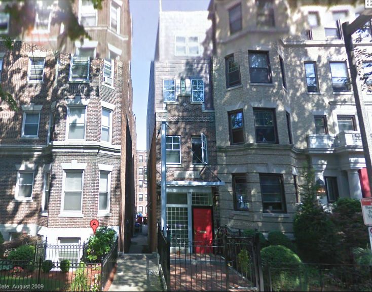
I don't quite care for the look of the building either. It sort of looks like the architect was inspired by the look of 37 Queensberry St. "The Pantry" in Fenway, however the material choice appears to be a cheap rendition of that design.

I'm not in the area any more so I can't run out an snag a picture, but for those that are curious, here is a screenie from Google Maps.

ThePantry_zps0bb79199.jpg


When you get down to basics, the proposed replacement for 16-20 Peterborough features a brick base topped by a more contemporary box, however, the pantry at least attempts to use a metal cladding with some sort of patina, which is far more interesting than whatever white cladding is being used in the illustration.

I feel for some of the tenants in the apartments in the rear of 25 Park drive (building to the left of the proposed bldg.) as they only really got late afternoon/evening sun and didn't have very bright living spaces with the current building in place. Some of the lower apartments are going to be pretty dark and shadowy when the new building goes up.

-Chase
 
I feel for some of the tenants in the apartments in the rear of 25 Park drive (building to the left of the proposed bldg.) as they only really got late afternoon/evening sun and didn't have very bright living spaces with the current building in place. Some of the lower apartments are going to be pretty dark and shadowy when the new building goes up.

I don't. If you want the sun don't move into a unit that faces northwest. Its not exactly rocket science.

On the other side of the spectrum, that white whatgarbageever cladding might wind up casting a decent amount of glare into the building. My old place was like that, there wasn't a minute in the 360 days a year the sun actually shone into my building. The apartment across the street was white stucco though and the glare was so bright I had to close my shades most of the day.

The design is pretty meh, but at least its contextual.
 
No more Canestaro? Boo!
Now I'll need a new secret parking spot for games....
 
The work being done to daylight the muddy has really changed the aesthetics of the area
 
Did I miss something in the thread? What's going on in that center area by the Landmark Center? (pictured above)
 
Will uncovering one block of the river really do anything?

Why not make the Brookline Ave Conduit larger? Or run a second one under the length of St Mary's St?

I imagine the real problem here is that beyond Brookline Ave, the river meanders and weaves around, slowing the course of the water. Seems the conduits are the only real way to fix this. That said, it will still be a nice new addition to the Emerald Necklace.
 
BostonUrbEx, I think by conduits you mean culverts.

The problem with culverts is that they have a ceiling so that when they reach capacity they back up in (seemingly) random and (sometimes) faraway places. Where they back up is dependent on the elevation of the rim of the catch basin or manhole.

Take out the culvert and the water can spread out along it's banks and the flood is localized. If this project is done right, that localized flooding will occur within a man-made wetland.

Depends what your definitions are. I take it that (but I'm not sure this is any "official" definition) culverts pass under something (ie: roads, highways, or in this case an empty parcel) whereas conduits are quite lengthy (like what runs under Brookline Ave, Deerfield St, and goes into the Charles near BU).

I'm suggesting it may be worth removing the flooding altogether, rather than simply allotting space for the river to flood out. There seems to be multiple conduit options available for getting flood waters into the Charles faster.
 
"Why not make the Brookline Ave Conduit larger? Or run a second one under the length of St Mary's St?"

There is line 30+ feet deep under St. Mary's Street which Brookline has been working on at the Monmouth Street intersection for what seems like ages.

The Brookline Avenue culvert was looked at as a possibility for expansion and was determined to be the most costly option only necessary in the case of a 200+ year flood.

Daylighting the river and massively expanding the existing culverts under the roadways was the most cost efficient means for eliminating the threat from 100+ year flooding. Mind you a large part of this project is dredging the entire Muddy River back to navigable depth and eliminating the invasive phragmities encroaching on the waterway.

The muddy river once was deep enough to dive in and boat on. A century worth of combined sewer and stormdrain runoff filled most of the river to knee deep.

The capacity of the waterway from Jamaica Pond to the Charles River is going to increase massively from this project. The improved water quality, elimination of invasive species, and replacement of long culverts with essentially bridges will reopen the possibility for the Muddy River as a recreational waterway. The dramatic improvement to the parkland in front of Emmanuel College and the victory gardens' area, with safe water views and no more sleaze or drug addicts, will also lead to a significant increase in property values.

The city has wanted this project for as long as I can remember but didn't want to spend a dime. When the major flooding occurred in the mid 1990s and the feds go involved the city suddenly took an active interest. This project had been delayed almost a decade because Brookline didn't want to cough up the cash for the Carlton Street footbridge to be repaired/replaced (those no good Boston kids might walk across!) and dredge out the river in an area damaged by the Brookline DPW's depot leaking chemicals. Brookline was finally sufficiently motivated by the feds to contribute their fair share or face a harsh penalty.

Once the home town team at Charter Environmental was selected, they had to come up with construction schedule which wouldn't drop an atomic bomb on LMA/RedSox/every other construction project on Boylston Street, which was not an easy task. That only lead to further delays.

The Mass Department of Environmental Protection also had an epic pissing contest with the EPA and the Army Corps of Engineers over preferring to keep everything shitty and on their own turf. The whole thing took decades and hundreds of millions of dollars of budgeting to move forward because of regulation. Probably took the city/state all of 5 minutes and 5 dollars to obliterate the original parkland when the MDC thought all the parkways should be widened into highways back in the 1950s.

0206_muddy-river.jpg

http://www.nae.usace.army.mil/Missions/ProjectsTopics/MuddyRiver.aspx
 
Last edited:
Probably took the city/state all of 5 minutes and 5 dollars to obliterate the original parkland when the MDC thought all the parkways should be widened into highways back in the 1950s.

Well put.
 
Construction under way at the river. Also Landmarked center landscaped their front door, but couldnt be bothered to address ADA violations. Lawsuit anyone?

DSC04421_zps4c105988.jpg


DSC04422_zpsb7a04726.jpg


DSC04424_zpsdb6966d9.jpg


DSC04425_zps1cfc5ec3.jpg
 
Those curbs should be easy enough to zap. Hard to believe that they overlooked that! Someone will bring it up you can be sure.
 
Especially since it's located directly across from the world's premier hospital district haha.
 
Well if any of you have a wheelchair, and have a lawyer friend, its an open and shut case.
 
Whoever stamped those LS drawings needs to have their license revoked. Not only are they missing ramps, but they are missing tactile strips as well.
 

Back
Top