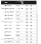
77% of the Blue Line under speed restrictions. From
10 stretches, including a nearly
three-mile-long segment at
10 mph from Bowdoin to Orient Heights (!). (You need to expand the chart by "Path" to see the full extent of that one, see second screenshot.)
The Red Line has a lower percentage of impacted track, but a much higher number of individual restrictions. As far as I can tell, there is at least one slow zone between every station pair except:
- Central -> Kendall
- Fields Corner -> Shawmut
- North Quincy -> Wollaston
- Quincy Center -> Quincy Adams (though there is a restriction within Quincy Adams)
- Downtown Crossing -> Park St
- Charles/MGH -> Kendall
- Kendall -> Central
- Porter -> Davis
- Central Ave -> Milton
- Cedar Grove -> Ashmont
As far as I can tell, every other stretch goes through at least one slow zone. And while (as far as I can tell) it is not possible to download this data into a spreadsheet to do actual analysis, my quick scan of the list suggests that as much as
5.6 miles of Red Line track is at a 10 mph restriction (excluding Mattapan Line).
The Orange Line looks like it has more 25 mph restrictions than 10 mph ones. But, there is a restriction of 10 mph 0.19 miles long between Tufts Med Ct and Chinatown, and a whopping 0.4 miles from Sullivan to Community College (which would take almost two and a half minutes to traverse at that speed).
Not even gonna look at the Green Line right now.
But uh yeah. All those headlines about "speed restrictions being lifted"? I know most of them were technically about the
systemwide restrictions being lifted, but, to be clear, a
substantial fraction of the T currently is under a speed restriction due to either a) poor track conditions or b) lack of documentation about maintenance of the system.


