Isn't that still technically a pilot?Also missing the Foxboro CR Line that now operates daily at all hours
You are using an out of date browser. It may not display this or other websites correctly.
You should upgrade or use an alternative browser.
You should upgrade or use an alternative browser.
General MBTA Topics (Multi Modal, Budget, MassDOT)
- Thread starter Waldorf
- Start date
This seems no different to the new Transit layer in Gmaps.File under: Looking a gift horse in the mouth:
Somebody at AB is the creator of this system map from 2017 which, to MassDOT's credit, is now out of date:
Given that it is missing: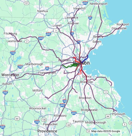
MBTA system map - Google My Maps
Ever wondered what the MBTA system looks like on an actual geographically-correct map? Here it is. This is a map of the transit routes operated by the Massachusetts Bay Transportation Authority in Boston, Quincy, Somerville, Cambridge, Revere, Brookline, Newton, etc. -- Doug Tillberg (2007)www.google.com
- Wachusett extension of the Fitchburg line (station is there but no purple line)
- Green Line extension to USq and Meford/Tufts
- Silver Line Gateway to Chelsea
Report on Facebook that yesterday’s Red Line disruption was caused by someone getting stuck under a train at Park Street: https://m.facebook.com/story.php?st...CTJBMThdha8jk1rzD8bqaXWxil&id=100079996396349
stick n move
Superstar
- Joined
- Oct 14, 2009
- Messages
- 13,482
- Reaction score
- 24,527
Nearly All Have Complied with MBTA Zoning – So Far

“State officials released data Thursday showing that, of the 175 towns and cities covered by the state’s landmark transit-oriented rezoning requirement, all but seven have met the law’s the first major requirement: submitting a plan that shows how they plan to comply with the law.
Of the 168 plans submitted, 46 have so far been reviewed and approved by DHCD. The state intends to post each community’s plan online at mass.gov/mbtacommunities.
Only Berkley, Carver, Holden, Marshfield, Middleborough, Raynham and Seekonk did not file action plans by the Jan. 31 deadline, a spokesperson for the state Department of Housing and Community Development said. The department plans to “follow up” with these towns to “assist with any submission issues or hurdles.” The towns represent around 2 percent of the total number of units that could be legalized or permitted under the MBTA Communities law.
“It’s overwhelmingly positive. It’s an indication that communities take this law seriously,” said Clark Ziegler, executive director of the Massachusetts Housing Partnership, the quasi-state entity tasked with helping municipalities plan out how they will comply with the law...”
https://bankerandtradesman.com/nearly-all-have-complied-with-mbta-zoning-so-far/
The EGE
Senior Member
- Joined
- Jun 29, 2013
- Messages
- 1,902
- Reaction score
- 5,245
Six of those aren't terribly surprising - local politics aside, they're not in a position where this "transit-oriented" rezoning can even be transit-oriented:
Middleborough will actually have a walkable, close-to-downtown station by the end of the year. But they've been burned pretty badly because they did build several hundred units of TOD housing, and now the transit is being taken away.
Don't get me wrong - I really like this law overall. But it is a very blunt instrument that needs some deftness.
- East Taunton station will be only 1,500 feet from the Berkeley border... but there's no route over the tracks, so it's a 3-mile walk to actually get into Berkley.
- Seekonk is only 5 miles from downtown Providence, but has no bus service there because of stupid federal rules. The closest stop is... oops, South Attleboro is indefinitely closed. So the town's sole transit is a bus route that runs through a small corner, with 12 round trips per day. Only two of which have less-than-half-hour connections with trains at Attleboro.
- Raynham is 2 miles to East Taunton from its closest point, or 4 to Bridgewater or Middleborough. None of those stations are served by buses that run through Raynham. Its sole transit is an hourly meandering GATRA route.
- Holden has no transit whatsoever. There's not even a WRTA bus that comes close enough to walk to.
- Carver has one bus route. It runs once a day and doesn't connect to the T.
- Marshfield doesn't have a bus to Greenbush. It has a single hourly route to Kingston, which has 25-minute connections to two morning trains, a 16-minute connection to a midafternoon train, and a decent connection to the 5:33 out of South Station. That last trip is only scheduled to run to Duxbury, and only runs to Marshfield on request.
Middleborough will actually have a walkable, close-to-downtown station by the end of the year. But they've been burned pretty badly because they did build several hundred units of TOD housing, and now the transit is being taken away.
Don't get me wrong - I really like this law overall. But it is a very blunt instrument that needs some deftness.
Don't get me wrong - I really like this law overall. But it is a very blunt instrument that needs some deftness.
It's pretty clear that the real purpose of the law has nothing to do with TOD or even the MBTA. That Boston wasn't included in it should have been an obvious clue.
And the real purpose of this law therefore is…?It's pretty clear that the real purpose of the law has nothing to do with TOD or even the MBTA. That Boston wasn't included in it should have been an obvious clue.
And the real purpose of this law therefore is…?
Haven't figured that part out. Only thing I could come up with is the Teachers Union is terrified what the school age population is going to look like in 10-15 years in the burbs... but I doubt they are that forward thinking.
- Joined
- Dec 10, 2011
- Messages
- 5,599
- Reaction score
- 2,719
I believe the purpose is as stated: to encourage more housing (and housing affordability) by building housing near stations.
The other part is obvious: it solves the political contradiction, inside voter's heads and hearts, that 40B also addressed
*My transportation policy professor called this the "Mile away highway paradox" of the 1970s: Everyone was in favor of new highways, they just wanted them a mile away.
The other part is obvious: it solves the political contradiction, inside voter's heads and hearts, that 40B also addressed
- Every progressive says they're in favor of more housing
- Every uber-capitalist says true property rights demand freedom of maximal development
- Yet, as individuals, voters don't want it in their town*
- ...unless they're sure that all other towns have the same obligation
- ...and therefore "my town" is only building a small % of the obligatory new development
- This law makes sure that every town appears more moderate than the sum of its neighbors
*My transportation policy professor called this the "Mile away highway paradox" of the 1970s: Everyone was in favor of new highways, they just wanted them a mile away.
Last edited:
Koopzilla24
Active Member
- Joined
- Dec 20, 2022
- Messages
- 459
- Reaction score
- 1,363
I'm taking this as a bad sign for South Coast Rail Phase 2
- Raynham is 2 miles to East Taunton from its closest point, or 4 to Bridgewater or Middleborough. None of those stations are served by buses that run through Raynham. Its sole transit is an hourly meandering GATRA route.
Delvin4519
Active Member
- Joined
- Oct 8, 2022
- Messages
- 937
- Reaction score
- 1,612
Alewife station on the Red Line to be closed until further notice due to a case of motor vehicle violence.

All Red Line service northbound will terminate at Davis. There are no service alerts for Alewife based bus routes, 62, 62/76, 76, 67, 350 at this time, at least so far.
For now, shuttle buses will connect riders to these 5 bus routes, requiring a double transfer for these low frequency bus routes. I guess an alternative could be to extend these bus routes to Davis, Porter, or Harvard, if the station will be closed for an extended amount of time. However, since it's a longer route to reach rapid transit for these bus routes, frequencies would decrease significantly for the bus routes. The alternative would be shuttle buses for an extended amount of time, but it requires two transfers to access these low frequency routes. What's the best way to do this?
I'd think diverting the 350 to Porter, and then the remaining bus routes could be diverted to Harvard, they'd have to use the traffic clogged Alewife Brook Parkway to get to Harvard, though.
Alewife station on the Red Line to be closed until further notice due to a case of motor vehicle violence.
View attachment 33828
All Red Line service northbound will terminate at Davis. There are no service alerts for Alewife based bus routes, 62, 62/76, 76, 67, 350 at this time, at least so far.
For now, shuttle buses will connect riders to these 5 bus routes, requiring a double transfer for these low frequency bus routes. I guess an alternative could be to extend these bus routes to Davis, Porter, or Harvard, if the station will be closed for an extended amount of time. However, since it's a longer route to reach rapid transit for these bus routes, frequencies would decrease significantly for the bus routes. The alternative would be shuttle buses for an extended amount of time, but it requires two transfers to access these low frequency routes. What's the best way to do this?
I'd think diverting the 350 to Porter, and then the remaining bus routes could be diverted to Harvard, they'd have to use the traffic clogged Alewife Brook Parkway to get to Harvard, though.
Davis makes the most sense because they have the busway at the station. Porter doesn't make any sense to turn around a bus, either the bus stop is inconvenient or the return loop is really challenging.
I have a thought that it's going to be closed tomorrow for clean-up and on Monday it'll be open in some form.
stick n move
Superstar
- Joined
- Oct 14, 2009
- Messages
- 13,482
- Reaction score
- 24,527
Insane.
Ripstoppingly wild!Insane.
However, I'm confused by the police using this word -- "intentional" -- here. i don't think of TPD as particularly good at investigatory powers, so, it feels a bit like they're using that term to state a sense of knowledge and authority over the situation that they don't have.
I have a feeling 5 more MPH, or a heavier and taller truck/SUV, and that car would also be in the station lobby. I know that a parking garages perimeter is supposed to be designed to keep cars in - and they seem to have worked here. Thankfully so far there only appears to be a single minor injury, but it could have been much much worse at a weekday rush or without the cold snap keeping people home.
Also, I'm going to go ahead and say that the truss holding up that roof looks like it bent pretty far. Cambridge FD has more photos, but some MBTA on-call contractor is going to make a buttload fixing this.
Also, I'm going to go ahead and say that the truss holding up that roof looks like it bent pretty far. Cambridge FD has more photos, but some MBTA on-call contractor is going to make a buttload fixing this.
Last edited:
Ripstoppingly wild!
However, I'm confused by the police using this word -- "intentional" -- here. i don't think of TPD as particularly good at investigatory powers, so, it feels a bit like they're using that term to state a sense of knowledge and authority over the situation that they don't have.
Unless transit police interviewed the driver and the driver said that the crash was intentional.
Heck - from the pictures it looks like I'd the car had been rear-wheel-drive it would likely be in the lobby right now.I have a feeling 5 more MPH, or a heavier and taller truck/SUV, and that car would also be in the station lobby. I know that a parking garages perimeter is supposed to be designed to keep cars in - and they seem to have worked here. Thankfully so far there only appears to be a single minor injury, but it could have been much much worse at a weekday rush or without the cold snap keeping people home.
Also, I'm going to go ahead and say that the truss holding up that roof looks like it bent pretty far. Cambridge FD has more photos, but some MBTA on-call contractor is going to make a buttload fixing this.
Delvin4519
Active Member
- Joined
- Oct 8, 2022
- Messages
- 937
- Reaction score
- 1,612
Davis makes the most sense because they have the busway at the station. Porter doesn't make any sense to turn around a bus, either the bus stop is inconvenient or the return loop is really challenging.
I have a thought that it's going to be closed tomorrow for clean-up and on Monday it'll be open in some form.
True. The problem with Davis is that most shuttles must travel via Clarendon Hill. There's also the 96 bus route to get to Mass Ave. from Davis, but they still have to travel via Alewife Brook Parkway to reach Alewife. Alewife Station isn't really in a good spot to run shuttle buses inbound to Davis, Porter, or Harvard. It's surrounded by heavily trafficked highways and parkways, plus Fresh Pond and other limited left turn routes, to try to get into Cambridge/Somerville/Belmont proper. It's especially true for trying to follow the rail lines into and out of town.
This got me thinking tangently. Take a map of all dedicated ROWs for railways or transitways, and try to run rail replacement shuttle buses for as many railway/transitway ROWs as possible. It also gives a look whether a conversion of a railway ROW into a subway line could eliminate a bus route (result:, very few existing bus routes are able to be scrapped with a rapid transit extension).
Using a blank map of transitway/railway ROWs, and run an assumption that all the inner core ROWs are converted into subway w/ more frequent stations. In the inner core w/ the 1-121 bus routes, it's no big deal to run shuttle buses, but finding a good route to run shuttles close to the railway ROW gets harder once outside of the inner core of Boston.
Map of potential (unverified) shuttle bus routes for all possible railway/transitway ROWs in the inner core Boston area, alongside the Highland Branch, Braintree Branch, and Watertown Branch. Red are the shuttle bus routes. Black are the railway ROWs, and cyan is the subway/transitway ROWs.
Alewife Station sticks out as being one of the worst spots to be running rail replacement shuttle buses. Running shuttle buses to replace a reactivated Watertown Branch subway/metro rail line through Alewife and Porter is very tricky and even worse than the existing Alewife Station as a terminus station, having to travel to Porter and Watertown, instead of Davis.
If a additional station or so were added to the Fairmount Line, then one tried to busitute the entire Fairmount Line, there's not a lot of good shuttle bus routes for the Fairmount Line.
Try this out for yourself, and share the possible results. Find a way to run rail replacement shuttle buses on as many lines as possible within the inner core area of Boston, bonus points if subway/regional rail service is extended to 128 with more frequent stations/stops. Assume any potential (not currently existing) station spot is an "actual" station that needs to be served with rail replacement shuttle buses as close to the station location as possible. These are the maps to base off of (I just cut the ROW off where the T buses stop running, regardless if it's an appropiate place to terminate a rail line or not). For now, assume existing roadway configurations remain in place.
Last edited:
Teban54
Senior Member
- Joined
- Nov 13, 2021
- Messages
- 1,142
- Reaction score
- 2,856
Minor note: During Green Line D branch shutdowns, shuttle buses typically use Beacon St, Park Dr and Brookline Ave, so that they can stop right at Fenway station on Park Dr.True. The problem with Davis is that most shuttles must travel via Clarendon Hill. There's also the 96 bus route to get to Mass Ave. from Davis, but they still have to travel via Alewife Brook Parkway to reach Alewife. Alewife Station isn't really in a good spot to run shuttle buses inbound to Davis, Porter, or Harvard. It's surrounded by heavily trafficked highways and parkways, plus Fresh Pond and other limited left turn routes, to try to get into Cambridge/Somerville/Belmont proper. It's especially true for trying to follow the rail lines into and out of town.
This got me thinking tangently. Take a map of all dedicated ROWs for railways or transitways, and try to run rail replacement shuttle buses for as many railway/transitway ROWs as possible. It also gives a look whether a conversion of a railway ROW into a subway line could eliminate a bus route (result:, very few existing bus routes are able to be scrapped with a rapid transit extension).
Using a blank map of transitway/railway ROWs, and run an assumption that all the inner core ROWs are converted into subway w/ more frequent stations. In the inner core w/ the 1-121 bus routes, it's no big deal to run shuttle buses, but finding a good route to run shuttles close to the railway ROW gets harder once outside of the inner core of Boston.
Map of potential (unverified) shuttle bus routes for all possible railway/transitway ROWs in the inner core Boston area, alongside the Highland Branch, Braintree Branch, and Watertown Branch. Red are the shuttle bus routes. Black are the railway ROWs, and cyan is the subway/transitway ROWs.
View attachment 33840
Alewife Station sticks out as being one of the worst spots to be running rail replacement shuttle buses. Running shuttle buses to replace a reactivated Watertown Branch subway/metro rail line through Alewife and Porter is very tricky and even worse than the existing Alewife Station as a terminus station, having to travel to Porter and Watertown, instead of Davis.
If a additional station or so were added to the Fairmount Line, then one tried to busitute the entire Fairmount Line, there's not a lot of good shuttle bus routes for the Fairmount Line.
Try this out for yourself, and share the possible results. Find a way to run rail replacement shuttle buses on as many lines as possible within the inner core area of Boston, bonus points if subway/regional rail service is extended to 128 with more frequent stations/stops. Assume any potential (not currently existing) station spot is an "actual" station that needs to be served with rail replacement shuttle buses as close to the station location as possible. These are the maps to base off of (I just cut the ROW off where the T buses stop running, regardless if it's an appropiate place to terminate a rail line or not). For now, assume existing roadway configurations remain in place.
View attachment 33837 View attachment 33838
As for Alewife, I wonder if it's better to run shuttle buses from Porter instead of Davis. However, that will be confusing operationally.
I've wondered why the T doesnt use Day and Dover between Davis and Mass Ave like the historical 96 street car did. Probably too challenging now with both sides with parked cars. Seems like on regular rather than emergency shuttle days tho it wouldn't be that challenging to restrict one side of parking for shuttle operations.