Delvin4519
Active Member
- Joined
- Oct 8, 2022
- Messages
- 937
- Reaction score
- 1,612
So yeah, that MBTA map had been on my radar for a few weeks (I think it was you who brought it up, so kudos), and I do plan to try recreating that at some point. Of course, working on that also means a dedicated job density map as a byproduct - I hear the calls from all other comments above you.
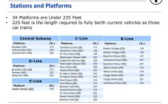
Has the MBTA mentioned the exact formula, or weighting between residents and jobs, that they used to create their "composite transit demand" metric? I see your second screenshot about some general ranges of residential and employment density they used to categorize service levels, so I can try reverse-engineering the weights, but a more explicit measure would obviously be better.
I do see how that can be a concern. The color scales were generated automatically using the Jenks natural breaks optimization, which I picked because it shows the nuances of urban areas pretty well - and urban areas were my initial focus. I'll see if there's a systematic way to finetune low-density areas further (perhaps adding one more color class?).
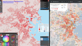
I got around to tinkering with the new 2020 population map and trying to reverse decode the conversion factors from population density to frequency, and same for employment (for employment I simply tinkered with this tool to compare with the T's map)
A factor of 7.5 residents/people per acre, or 4800 residents/people per square mile, is roughly equivalent to hourly transit service. (Use the population weighted adjustment factors in the MBTA's PDF to get the "adjusted population density" map.)
A similar factor of 7.5 employees/jobs per acre, or 4800 employees/people per square mile, is also roughly equivalent to hourly transit service.
For the attached screenshots of Teban54's population map, I can't get the exact buckets since the 2020 map buckets do not map cleanly to the proper intervals for testing.
Anyhow, here's the conversion tables as needed to recreate the MBTA's market analysis frequencies map:
Important definition: Density can refer to:
1. Population density
2. Employment density
3. Combined total population + employment density.
They all use the same conversion table/factor. So a parcel with 30 residents and 30 jobs per acre (4 vph - 15 min headways individually), gives a combined density of 60 per acre = 8 vph = 8 min supported frequency.
This conversion factor is likely probably the factor used by the MBTA to create their maps. Whether the conversion factor likely used by the T to convert from densities to supported frequencies, should be higher or lower, is another matter, but the conversion factor below is the one that would best recreate the MBTA's map.
The underlined values are the bucket values needed for a 8-color-scale, and the italicized one for if a 9th color scale is available. (Parcels as 0 should be marked "0" using a "null" color)
| Supported transit service frequency | Density per acre | Density per square mile | Density per square kilometer |
|---|---|---|---|
| N/A | 0 | 0 | 0 |
| Every 2 hours or less frequent (< 0.5 vph) - SATS | 0.01 - 3.75 | 1 - 2400 | 1 - 926 |
| Every 80 - 120 minutes (0.5 - 0.75 vph) - SATS | 3.75 - 5.625 | 2400 - 3600 | 926 - 1389 |
| Every 60 - 80 minutes (0.75 - 1 vph) - SATS | 5.625 - 7.5 | 3600 - 4800 | 1389 - 1852 |
| Every 40 - 60 minutes (1 - 1.5 vph) - SATS | 7.5 - 11.25 | 4800 - 7200 | 1852 - 2778 |
| Every 30 - 40 minutes (1.5 - 2 vph) - SATS | 11.25 - 15 | 7200 - 9600 | 2778 - 3704 |
| Every 24 - 30 minutes (2 - 2.5 vph) - SATS | 15 - 18.75 | 9600 - 12000 | 3704 - 4630 |
| Every 20 - 24 minutes (2.5 - 3 vph) - SATS | 18.75 - 22.5 | 12000 - 14400 | 4630 - 5556 |
| Every 15 - 20 minutes (3 - 4 vph) - PWTL | 22.5 - 30 | 14400 - 19200 | 5556 - 7408 |
| Every 12 - 15 minutes (4 - 5 vph) - PDJW | 30 - 37.5 | 19200 - 24000 | 7408 - 9260 |
| Every 10 - 12 minutes (5 - 6 vph) - PDJW | 37.5 - 45 | 24000 - 28800 | 9260 - 11112 |
| Every 8 - 10 minutes (6 - 8 vph) - SUAW | 45 - 60 | 28800 - 38400 | 11112 - 14816 |
| Every 6 - 8 minutes (8 - 10 vph) - SUAW | 60 - 75 | 38400 - 48000 | 14816 - 18520 |
| Every 5 - 6 minutes (10 - 12 vph) - SUAW | 75 - 90 | 48000 - 57600 | 18520 - 22224 |
| Every 3 - 5 minutes (12 - 20 vph) - SUAG | 90 - 150 | 57600 - 96000 | 22224 - 37040 |
| Every 2 - 3 minutes (20 - 30 vph) - SUAG | 150 - 225 | 96000 - 144000 | 37040 - 55560 |
| Every 1.5 - 2 minutes (30 - 40 vph) - SUAG | 225 - 300 | 144000 - 192000 | 55560 - 74080 |
SUAG - "show up and go"
SUAW - "show up and wait"
PLJW - "plan departure, journey whenever"
PWTL - "plan when to leave"
SATS - "schedule around the schedule"
I essentially just marked these for each multiple of 5, so 5 - 10 - 15 - 20 until I ran out.
SUAW - "show up and wait"
PLJW - "plan departure, journey whenever"
PWTL - "plan when to leave"
SATS - "schedule around the schedule"
I essentially just marked these for each multiple of 5, so 5 - 10 - 15 - 20 until I ran out.
To get an ideal walkshed for a subway station, a gridded street layout would give = (.5 mile walkshed + gridded street grid = a diagonal square with diagonal sides of 0.7 mi (1 mile total - .5 mi walk on a N-S/E-W street on either side of a station) = 0.5 square mile walkshed.
So for a subway station to have at least a density to support at least 10 minute service (highlighted in red in the table), you want a minimum of 14,400 residents and jobs combined within the diagonal square (since a 10 minute walkshed can only cover 0.5 sq miles on a perfect street grid - 28,800 per sq mile for 10 minute service - 0.5 sq miles = 14,400).
If using perfect circles for these measurements, the 10 minute walkshed in a perfect circle is 0.785 sq miles, or 22,608 jobs and residents combined in a given circle for a 10 minute subway service (out of 28,800 sq mi density).
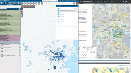
Also, here's some fun trivia I pulled from this particular map tool:
Of the ~1.27 million population within the BERy service area, ~762.7k live within a 10 minute walk of a current or historical railroad ROW; or subway station (60%) (includes all mainline RR ROWs, the Cambridge subway, East Boston subway, Seaport transitway, and the Green Line tunnel).
Including Lynn, Quincy, Waltham, and Melrose, ~822.9k out of a total of ~1.58 million live within a 10 minute walk of the aformentioned RR ROWs (52.1%).
868.7k can be covered with extensions from Lynn/Waltham/Quincy terminals (& Wyoming Hill), to Swampscott/Roberts/Braintree/Melrose Highlands (55.0%).
14,200 out of 49,000 Everett residents live within a 10 minute walk of the Saugus Branch Railroad or the Eastern Railroad (the aformentioned map tool I used gave me 41.5k (34.2%) for Everett total).
33,000 out of 76,000 Allston Brighton residents live within a 10 minute walk of the Boston & Worcester (B & A) Railroad (~27,500 - 39.3%) or the Highland Branch Railroad (~5,510 - 7.9%). (The same map tool gave me 69.8k for the neighborhood population - 47.2%)
- Conversion of the 64, 65, 86, and 70 to frequent bus routes (alongside the 66 and B branch - the 64 truncated to Faneuil), and a B & A subway replacing the 57 as the high frequency east-west route, would provide high frequency service to 92.4% of Allston-Brighton within a 10 minute walk, covering all of the densest parts of the neighborhood. Only ~5,300 Brighton residents bordering Newton Corner would be without high frequency service under such a scenario. Almost the entirety are west of the Washington St & Breck Ave. 57 bus stop, in low density auto-centric parcels marked as supporting 30 minute or hourly service by the MBTA.
Attachments
Last edited: